Snow piles up in Cape Breton; weekend weather rainy and windy
 A woman walks near Citadel Hill in Halifax in this file photo. Environment Canada has issued weather alerts warning of potentially icy roads, slippery sidewalks, heavy rain and strong winds across much of the region. (THE CANADIAN PRESS/Andrew Vaughan)
March weather was out like a lion for Cape Breton. The Island was thumped by another heavy, spring snowfall Thursday into Friday. Friday morning reports from a network of volunteer observers came in with amounts of 10 to 20 cm, with snow still falling and accumulating. By noon on Friday, I had unofficial reports from several communities in Cape Breton that new snow totalled 20 to 30 cm.
The cold front brought in snow amounts ranging from a trace up to several centimetres for other areas of the Maritimes on Thursday. Some locally higher amounts of near 10 cm reported on parts of the North Shore of mainland Nova Scotia. The snow came in the form of squalls which reduced visibility for periods of time leading to tricky driving conditions.
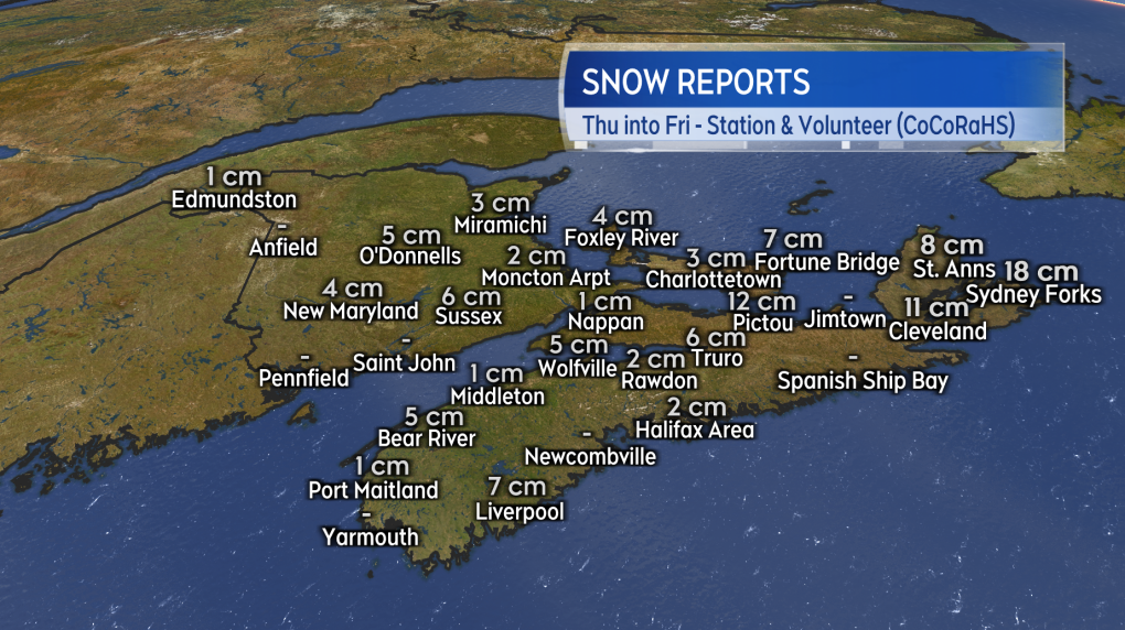 Snowfall for much of the Maritimes ranged from trace amounts up to several centimetres. Snow continued into Friday for Cape Breton with sources on the Island reporting amounts of 10 to 30 cm.
No April fool’s joke, another round of inclement weather is headed into the Maritimes this weekend.
This next weather maker is a strong low pressure system in the mid-western US. The centre of the storm will move into the St. Lawrence River Valley but the associated weather fronts will push into the Maritimes on Saturday. The system is triggering severe thunderstorms with a risk of tornadoes in the United States but for the Maritimes it will be snow turning to rain accompanied by gusty winds.
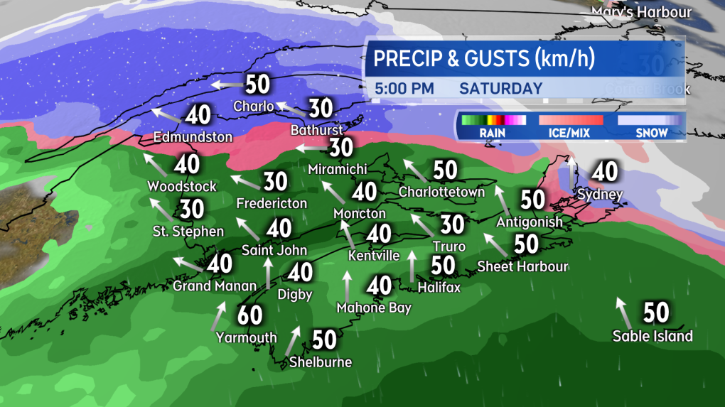 Snow turning to rain develops across the Maritimes, southwest to northeast, Saturday morning into afternoon.
Snow will start before sunrise on Saturday in the southwest of New Brunswick and the southwest of Nova Scotia. The snow will then turn to rain and spread across the region by early Saturday afternoon. Initial snow before the rain is expected to be limited to up to a few centimetres for most. Parts of northern New Brunswick could pick up a slushy 5 to 10 cm before a switch to rain. Rain totals of 5 to 15 mm expected except 15 to 30 mm for the tri-county region of southwestern Nova Scotia. Precipitation will ease to scattered showers and flurries Saturday night.
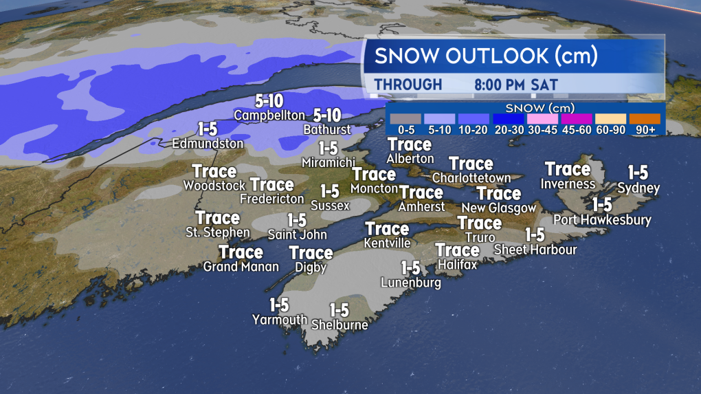 The change to rain is expected to be quick enough to limit snow for most of the region. Parts of northern New Brunswick might pick up 5 to 10 cm of slushy snow.
A gusty southerly wind will accompany the snow turning to rain. Gusts on Saturday will peak between 30 and 60 km/h. The wind becomes westerly on Sunday in the wake of the system and is expected to reach gusts of 40 to 70 km/h. The wind is forecast to diminish Sunday night. The west wind will bring in some colder air off the continent and low temperatures Sunday night are expected to be below freezing across the region. Wet surfaces could turn icy as a result.
Forecast updates and regional weather conditions on CTV News Atlantic 5, 6, and 11:30 PM.
Shopping Trends
The Shopping Trends team is independent of the journalists at CTV News. We may earn a commission when you use our links to shop. Read about us.


CTVNews.ca Top Stories

Winter storms, wind and freezing rain: Hazardous conditions expected in some parts of Canada
Hazardous conditions are expected in some parts of Canada this week.
GST break could cost Ottawa $2.7B if provinces don't waive compensation: PBO
The parliamentary budget officer says the federal government's GST holiday could cost as much as $2.7 billion, if provinces don't waive their entitlement to compensation.
Family spokesman says slain Edmonton security guard had only been working 3 days
A spokesman for the family of a security guard who police say was murdered while patrolling an Edmonton apartment building last week says the man had only been on the job for three days.
The Canada Post strike involving more than 55,000 has hit 25 days
The Canada Post strike involving more than 55,000 workers has hit 25 days.
Police search for three men who escaped from immigration holding centre in Quebec
Authorities are searching for three Chilean nationals who escaped from the Laval Immigration Holding Centre north of Montreal.
Sask. hockey player recovering after near fatal skate accident during game
The Sask East Hockey League (SEHL) has released details of a near fatal accident at one of its games over the weekend – which saw a Churchbridge Imperials player suffer serious injuries after being struck with a skate.
Celebrities spotted at Taylor Swift's final Eras Tour performance in Vancouver
Taylor Swift fans from around the world gathered in Vancouver on Sunday to witness the final performance of her massively popular Eras Tour, including a few celebrities.
'Emilia Perez' leads Golden Globe nominations with 10, followed by 'The Brutalist' and 'Conclave'
Jacques Audiard's audacious musical 'Emilia Perez,' about a Mexican drug lord who undergoes gender affirming surgery to become a woman, led nominations to the 82nd Golden Globes on Monday, scoring 10 nods.
BoC expected to lower interest rates again, with odds leaning toward larger cut
Financial markets and forecasters are betting on another jumbo interest rate cut from the Bank of Canada this week.
Toronto
-

Service disruptions lead to overcrowding at busy subway stations: Toronto police
Toronto police say signal issues have led to crowding at some busy subway stations, including Union Station, this morning.
-
GTA sees freezing rain, icy conditions during morning rush hour
Parts of the GTA remain under a freezing rain warning this morning as Environment Canada warns of slippery driving conditions today.
-
Man allegedly seen peering into Toronto home wanted by police
A man who was allegedly seen twice peering into a person’s home late at night in downtown Toronto last month is wanted by police.
Calgary
-

Man dead after incident at workplace in northeast Calgary
Occupational Health and Safety and the Calgary Police Service are investigating how a man died on Sunday night.
-
Some Olympic Plaza bricks can be saved, city now says
In a surprise move, the City of Calgary said Monday that there's a possibility that some of the thousands of commemorative bricks that make up Olympic Plaza can be recovered.
-
GST break could cost Ottawa $2.7B if provinces don't waive compensation: PBO
The parliamentary budget officer says the federal government's GST holiday could cost as much as $2.7 billion, if provinces don't waive their entitlement to compensation.
Edmonton
-

Family spokesman says slain Edmonton security guard had only been working 3 days
A spokesman for the family of a security guard who police say was murdered while patrolling an Edmonton apartment building last week says the man had only been on the job for three days.
-
WEATHER
WEATHER Josh Classen's forecast: A cool down and some occasional flurries
After a really warm weekend, temperatures will stay on the mild side for one more day. Cooler air starts to dig in Tuesday.
-
Oilers starting to look and play like a contender
After another typically slow start to the season, the Edmonton Oilers finally seem to be living up to some of the promise that had many believing they could get back to a Stanley Cup final, not long removed from losing in Game 7 of the final to the Florida Panthers last season.
Montreal
-

Quebec Health Minister Dube may not seek another term
Health Minister Christian Dube repeated to CTV News what he said on Radio-Canada’s Tout le Monde en Parle that he does not intend to run in the 2026 provincial election.
-
This Ontario family's car was stolen in Montreal with their dog still in it
An Ontario family's car was stolen with their dog still in it. The car was found, but their furry friend is missing.
-
Freezing rain expected in Quebec on Wednesday
Much of Quebec was covered with a bed of snow over the weekend, which is expected to melt throughout the week thanks to forecast rainfall, before freezing again, according to Environment Canada.
Ottawa
-
 SPECIAL WEATHER STATEMENT
SPECIAL WEATHER STATEMENT Up to 5 cm of snow, freezing rain expected in Ottawa
Another blast of winter weather is set to hit Ottawa this week, with 2 to 4 centimetres of snow in the forecast for today and the risk of freezing rain or drizzle tonight and on Tuesday. Environment Canada has issued a special weather statement for Ottawa and eastern Ontario, warning freezing rain and freezing drizzle are possible.
-
Feds provide funding for autonomous shuttle bus testing in Kanata
The federal government is spending $1.4 million to test an autonomous shuttle bus in Kanata. Transport Minister Anita Anand announced $14.68 million in funding for 35 projects to enhance road safety across Canada, including three projects in Ottawa.
-
Number of speeding tickets dropping at Ottawa's busiest photo radar camera
King Edward Avenue continues to be the hot spot for speeders on Ottawa roads this year, but the number of tickets issued by the new photo radar camera continues to decline as drivers adjust their speeds on the Lowertown road.
London
-

Charges laid after tow truck operator injured after helping stranded motorist
According to police, a tow operator had removed the suspect vehicle from the ditch earlier, where it had been stuck in the snow. While waiting for payment, the driver of the suspect vehicle sped off and struck the tow operator, launching them into the ditch.
-
Fatal, four-vehicle crash on Sunday
A 53-year-old from Toronto was pronounced deceased at the scene. Another driver was airlifted to a trauma centre. Two passengers were transported to hospital with non-life-threatening injuries, and two other drivers were not injured.
-
A change in precipitation to start the week, more snow on the way
The London area will get a bit of a break from the snow to start the week, but it's been replaced with rain. Temperatures will remain above zero with periods of rain continuing throughout the day on Monday with a chance for sunshine on Tuesday.
Barrie
-

Freezing rain creates slick conditions in Simcoe County
After all the snowfall that hit Muskoka and Simcoe County over the last week, Barrie and many other parts of the region are under a freezing rain warning as of Sunday evening.
-
Fleeing driver gets stuck in Gravenhurst snowbank
Bonnie and Clyde never had to deal with snowbanks.
-
City tells residents 'Can't flush this'
Barrie's water treatment staff warn residents of dire consequences when 'unflushables' hit the drains.
Northern Ontario
-

Sask. hockey player recovering after near fatal skate accident during game
The Sask East Hockey League (SEHL) has released details of a near fatal accident at one of its games over the weekend – which saw a Churchbridge Imperials player suffer serious injuries after being struck with a skate.
-
Northern Ontario man sentenced for killing his dog
WARNING: This article contains graphic details of animal abuse which may be upsetting to some readers. A 40-year-old northern Ontario man is avoiding prison after pleading guilty to killing his dog earlier this year.
-
Wanted man arrested in North Bay
North Bay police arrested a wanted federal offender who is accused of breaching his statutory release nearly two weeks ago.
Kitchener
-
Fatal, four-vehicle crash on Sunday
A 53-year-old from Toronto was pronounced deceased at the scene. Another driver was airlifted to a trauma centre. Two passengers were transported to hospital with non-life-threatening injuries, and two other drivers were not injured.
-
Wanted man arrested by Waterloo Regional Police Service
A man wanted on a Canada-wide warrant was arrested in Kitchener.
-
Man facing more than two dozen charges after arrest in Guelph
A man is facing a long list of charges after the Guelph Police Service received two complaints on Sunday afternoon.
Windsor
-

Woman dies after vehicle crashes into south Windsor home
Windsor police say a 73-year-old woman has died after a vehicle hit a house in south Windsor.
-
What’s lowering Detroit River water levels?
If you’ve noticed the current along the Detroit River sitting lower than usual, you’re not alone.
-
'They’re going through hell': TLC Foundation treats children with cancer to free shopping spree
The TLC Foundation invited over 200 children from southwestern Ontario to Toys R Us in London, Ont. for a free shopping spree.
Winnipeg
-

Road and school closures in place in Southern Manitoba due to snowy conditions
The winter wallop in southern Manitoba has prompted a number of highways and schools in Manitoba to be closed, and is resulting in several buses not running on Monday.
-
The Canada Post strike involving more than 55,000 has hit 25 days
The Canada Post strike involving more than 55,000 workers has hit 25 days.
-
Wintery weather warnings in effect for southern Manitoba
Environment and Climate Change Canada has issued several snowfall, winter storm and freezing rain warnings for much of southern Manitoba.
Regina
-
Sask. hockey player recovering after near fatal skate accident during game
The Sask East Hockey League (SEHL) has released details of a near fatal accident at one of its games over the weekend – which saw a Churchbridge Imperials player suffer serious injuries after being struck with a skate.
-
Several Sask. highways closed, travel not recommended on others following weekend storm
Several highways are closed across southern Saskatchewan Monday morning, including parts of Highway 1, after a weekend with freezing rain and winter storm warnings across the province.
-
Creativity for a cause: Lego showcase raises funds for White City library
The White City Community Centre held a showcase over the weekend – featuring brilliant and detailed creations from Saskatchewan's finest masters of building with Lego.
Saskatoon
-

Saskatoon honours Bella Brave with birthday celebration
It has been five months since Bella Thompson, widely known as Bella Brave to her millions of TikTok followers, passed away after a long battle with Hirschsprung’s disease and an auto-immune disorder.
-
Sask. hockey player recovering after near fatal skate accident during game
The Sask East Hockey League (SEHL) has released details of a near fatal accident at one of its games over the weekend – which saw a Churchbridge Imperials player suffer serious injuries after being struck with a skate.
-
No injuries following kitchen fire in Saskatoon
Saskatoon fire crews responded to a kitchen fire on the 100 block of Avenue U South Sunday afternoon.
Vancouver
-

End of the Eras: Vancouver sweeps up after Taylor Swift's final bow
Pop star Taylor Swift has thanked Vancouver for hosting the final show of her "beloved Eras Tour."
-
-
Some cancer patients may forgo care due to high treatment-related costs: report
Since Natalie Lipschultz was diagnosed with stage three colorectal cancer in 2019, she estimates the illness has cost her more than $20,000 in out-of-pocket expenses.
Vancouver Island
-

Taylor Swift ends record-smashing Eras Tour in Vancouver, after glittering global run
Taylor Swift took the stage for the final time on her record-smashing Eras Tour, watched by tens of thousands of delirious fans in Vancouver's BC Place arena and by millions on livestreams around the world.
-
Some cancer patients may forgo care due to high treatment-related costs: report
Since Natalie Lipschultz was diagnosed with stage three colorectal cancer in 2019, she estimates the illness has cost her more than $20,000 in out-of-pocket expenses.
-
Young Swiftie scores seat at sold-out Eras Tour after holding up sign outside BC Place
Thirteen-year-old Sidney Ha was among the throngs of Swifties without a ticket to the Eras Tour in Vancouver who gathered outside of a fenced-off BC Place Saturday night – but thanks to one stranger’s act of kindness, she ended up inside the stadium singing along.
Kelowna
-

Study of 2023 Okanagan wildfires recommends limiting development in high-risk areas
A study into the devastating wildfires that struck British Columbia's Okanagan region in 2023 has recommended that government and industry limit development in high-fire-risk areas.
-
Kelowna, B.C., to host the Memorial Cup in the spring of 2026
The Western Hockey League's Kelowna Rockets will host the Memorial Cup in the spring of 2026, the Canadian Hockey League said Wednesday.
-
545 vehicles impounded in 332 days: BC Highway Patrol pleads for drivers to slow down
Mounties with the BC Highway Patrol in Kelowna say they've impounded more than 545 vehicles for excessive speed and aggressive driving so far this year. That works out to more than 1.6 per day.


