Snowfall warnings and weather statements for the Maritimes ahead of Friday wintry mix
Thursday is an unusually warm February day for the Maritimes. Most high temperatures will reach the mid-to-high single digits and some into the low-teens. There will be some record-high temperatures set for a Feb. 16, though that won’t be able to be checked until Thursday evening. Take a few minutes longer outside and consider getting a few more errands done because a wintry mix of weather returns on Friday.
Snowfall and freezing rain warnings are in effect for much of New Brunswick. The Snowfall warnings are calling for total snow and ice pellet accumulation of 15 to 25 cm. A Snowfall warning has also been issued for Prince Edward Island calling for 15 to 25 cm.
A Freezing rain warning is in effect for Nova Scotia except for Digby, Yarmouth, Shelburne, and Queens Counties in the southeast where more rain is expected. Northern Inverness and Victoria counties are also not under the freezing rain warning but those areas should expect a mix of snow and ice pellets with a risk of some freezing rain mixing in.
The snow, ice pellets, freezing rain, and rain will be the result of a Texas low. Here’s an outlook through Friday:
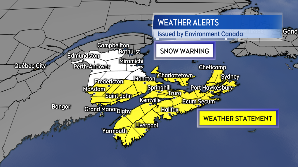 Snowfall warnings and special weather statements extend across the Maritimes. Check the latest information in the alert in effect for your area as the weather conditions, and impacts, will be varied across the region Friday.
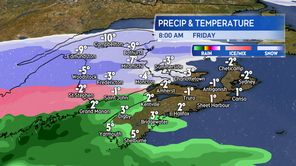
FRIDAY MORNING
By sunrise Friday, an accumulating mix of snow and ice pellets will already be falling across New Brunswick and building into Prince Edward Island. There is a risk of freezing rain along the Bay of Fundy coastline in New Brunswick, Prince Edward Island, and northern/eastern areas of Nova Scotia, including the North Shore into Cape Breton.
The rest of Nova Scotia will see rain develop through the morning as temperatures initially remain above freezing. It won’t take long for the rate of snowfall and ice pellets to be enough to gather on surfaces, such as roads, creating slippery conditions.
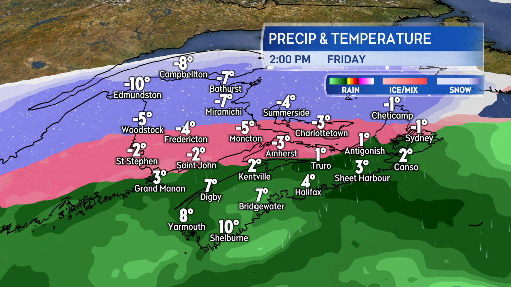
FRIDAY AFTERNOON
Snow and ice pellets will continue to accumulate in New Brunswick and Prince Edward Island Friday afternoon. A mix of ice pellets and freezing rain is expected for Cumberland/Colchester Counties, the North Shore, and much of Cape Breton, though it may still be just rain around the Atlantic coastline of the island. Rain will continue to fall across the remainder of mainland Nova Scotia. The precipitation will be steady for most, though it will turn lighter for northern areas of New Brunswick moving through the afternoon.
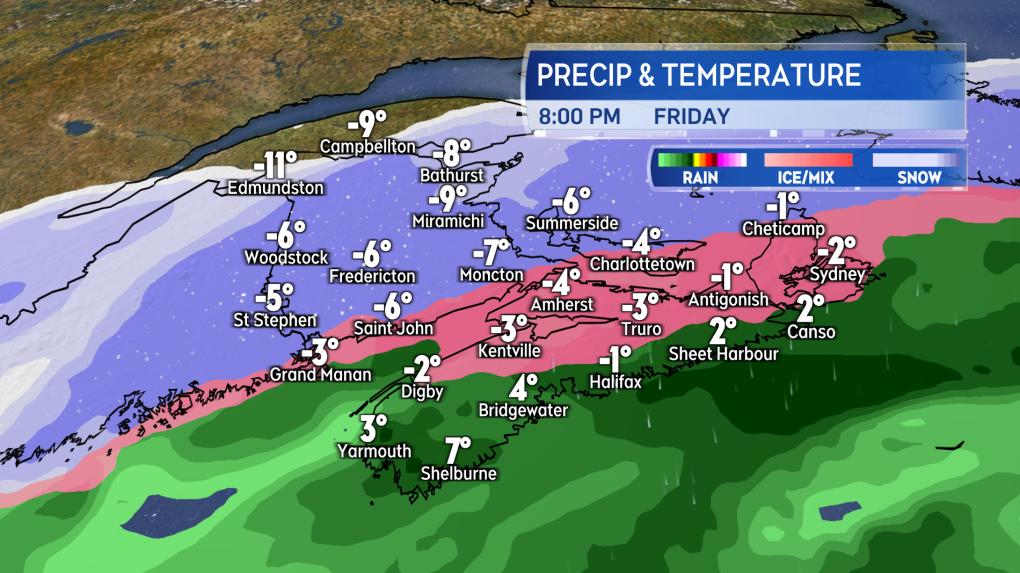
FRIDAY EVENING
Snow and ice pellets will continue to fall in New Brunswick in the evening, but will be lighter in northern and central parts of the province. Prince Edward Island will continue to see accumulating snow and ice pellets. The rain will start to turn to freezing rain and ice pellets in Nova Scotia. Atlantic coastal areas of Nova Scotia should get into the icy precipitation between 8 p.m. and midnight. During the overnight hours, light snow will end for New Brunswick, snow will ease to flurries for Prince Edward Island, and Nova Scotia will turn to scattered light snow and flurries that should end for most before noon on Saturday.
SNOW AND ICE
Much of New Brunswick, Prince Edward Island, and northern Inverness/Victoria Counties in Cape Breton will pick up 10-20 cm of snow and ice pellets. Higher snow and ice pellet accumulations of 20-30 cm look possible in a band across central New Brunswick and east into Prince County, P.E.I. Snow accumulation should be a bit lower towards Saint John and the Bay of Fundy coastline, with more freezing rain and ice pellets expected before a turn to snow. Five to 10 cm of snow and ice pellets could eventually add up in northern and eastern areas of Nova Scotia. Rain, freezing rain, and ice pellets are expected initially for those areas followed by a turn to snow Friday evening. The remainder of Nova Scotia should get about 5-15 mm of rain and freezing rain then about 2-5 cm of snow early Saturday morning.
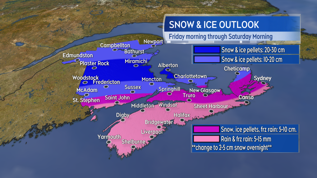 The most snow and ice pellet accumulation is expected in New Brunswick and Prince Edward Island. There is a risk of freezing rain across southern New Brunswick, Prince Edward Island, and Nova Scotia.”>
WIND
Wind isn’t expected to be a major component of the Friday weather. It is variable in direction across the region with most gusts peaking in a range of 30-50 km/h during the day on Friday. A northerly wind Friday night in Saturday morning will hit some slightly higher gusts of 40-60 km/h. Keep in mind that in this type of snowy, icy mix we are more likely to see weight added to tree branches and power infrastructure. That could increase the impact of the wind and create a risk of power outages.


CTVNews.ca Top Stories

They were due to leave for their dream cruise in May. Three months on they’re still stuck at the departure port
It was the years-long cruise that was supposed to set sail, but saw its departure postponed… postponed… and postponed again.
Ontario's first domestic case of human rabies since 1967 confirmed in Brant County
An Ontario resident remains in hospital after testing positive for rabies.
How to get a whole city to stop lawn watering? Experts say praise over punishment
For almost two weeks, a city of 1.6 million people has been told once again to stop watering lawns, take three-minute showers, hold off on laundry and dishes, and let the yellow in their toilets mellow.
4-year-old drowns in backyard pool on Montreal's South Shore
The lifeless body of a child was discovered in a residential swimming pool in Longueuil, on Montreal's South Shore, late on Friday afternoon.
Trudeau insists he's staying on as Liberal leader. But what if he changes his mind?
The Liberal caucus is set to meet in Nanaimo, B.C., next week for a retreat ahead of the fall parliamentary sitting. Prime Minister Justin Trudeau insists he will lead his party into the next election despite polls citing his unpopularity among Canadians. Here's a look at what would happen if he decided to call it quits.
Two astronauts are left behind in space as Boeing's troubled capsule returns to Earth empty
Boeing's first astronaut mission ended Friday night with an empty capsule landing and two test pilots still in space, left behind until next year because NASA judged their return too risky.
Despite union protest, new hybrid work rules for federal employees kick in Monday
Public service unions will start the week with an early-morning rally opposing the policy. But despite the unions' 'summer of discontent' and an ongoing court challenge, the new rules will still kick in on Sept. 9.
Georgia school shooting suspect was troubled by a broken family, taunting at school, his father said
Both Colt, 14, and Colin Gray, 54, are charged in the killings of two students and two teachers Wednesday at Apalachee High School in Barrow County, outside Atlanta.
Biden's disastrous debate performance offers lessons for Harris and warnings for Trump
The first and last debate between Biden and Donald Trump started a chain reaction leading to U.S. Vice President Kamala Harris replacing Biden at the top of the Democratic ticket.
Shopping Trends
The Shopping Trends team is independent of the journalists at CTV News. We may earn a commission when you use our links to shop. Read about us.


Toronto
-

Hit-and-run in Whitby leaves 1 woman seriously injured: police
A woman is in hospital in serious condition after she was struck in a hit-and-run in Whitby early Saturday morning.
-
Drug checking in Toronto could be significantly impacted by closure of supervised consumption sites
Ontario’s plan to shut down six supervised consumption sites in Toronto may significantly impact one local organization’s ability to verify and analyze the city’s unregulated drug supply.
-
2 people critically injured in rollover on Highway 401 in Mississauga: paramedics
Two people have been critically injured in a vehicle rollover on Highway 401 in Mississauga, Peel paramedics say.
Calgary
-

How to get a whole city to stop lawn watering? Experts say praise over punishment
For almost two weeks, a city of 1.6 million people has been told once again to stop watering lawns, take three-minute showers, hold off on laundry and dishes, and let the yellow in their toilets mellow.
-
Calgary mayor meets with province over Green Line, Feds 'surprised' by funding changes
Calgary Mayor Jyoti Gondek met with representatives from the Alberta government Friday, just days after councillors voted to start the process to 'wind down' the $6.2 billion Green Line and transfer the cost and risk to the provincial government.
-
They were due to leave for their dream cruise in May. Three months on they’re still stuck at the departure port
It was the years-long cruise that was supposed to set sail, but saw its departure postponed… postponed… and postponed again.
Edmonton
-

Charges laid after motorcyclist posts video of dangerous driving on social media
A motorcyclist is facing multiple charges of driving dangerously after he posted social media videos of himself breaking the law.
-
They were due to leave for their dream cruise in May. Three months on they’re still stuck at the departure port
It was the years-long cruise that was supposed to set sail, but saw its departure postponed… postponed… and postponed again.
-
How to get a whole city to stop lawn watering? Experts say praise over punishment
For almost two weeks, a city of 1.6 million people has been told once again to stop watering lawns, take three-minute showers, hold off on laundry and dishes, and let the yellow in their toilets mellow.
Montreal
-

Quebec to authorize advance requests for medical assistance in dying as of Oct. 30
Quebec will authorize advance requests for medical assistance in dying (MAID) without waiting for Ottawa to amend its Criminal Code.
-
4-year-old drowns in backyard pool on Montreal's South Shore
The lifeless body of a child was discovered in a residential swimming pool in Longueuil, on Montreal's South Shore, late on Friday afternoon.
-
Montreal man given $664 fine for tying dog to parking meter while grabbing a croissant
A Montreal man who tied his dog to a parking meter while he entered a bakery is now facing a hefty fine for breaking a law he had no idea existed.
Ottawa
-
 NEW THIS MORNING
NEW THIS MORNING City of Ottawa staff begin educating residents on new 3-item garbage limit. Here's what you need to know
Starting September 30, all Ottawa households will be limited to three items of curbside waste every two weeks. Environmental Education Assistants (EEAs) will be visiting homes across the city in September, October and November to provide information about the new garbage limit and answer any questions.
-
Frustration for some federal public servants and executives mandated back to the office
Starting Monday, federal employees will be required to be in the office three days a week, instead of the current two, and that means another day dealing with a commute that some say has gotten worse.
-
Ottawa mother with son living with autism denied thousands of dollars in claims
An Ottawa mother says it’s been a nightmare dealing with her insurance company after she was denied tens of thousands of dollars worth of claims for her autistic son’s therapies.
London
-

Jacob Julien scores late to give London Knights preseason win, play again Saturday afternoon
Jacob Julien sent the crowd at Budweiser Gardens home with a smile after scoring the game winning goal with just 14 seconds left in regulation Friday night.
-
Chatham-Kent police remind drivers to watch for deer
Chatham-Kent police are reminding drivers to watch for deer while out on the roads, especially at dusk and dawn.
-
CTV News London’s top stories from this week
In case you missed it, CTV News London has compiled all of the top local stories from this week into one video.
Barrie
-

Barrie police investigate collision involving pedestrian and 2 motorcycles
Police in Barrie are investigating a collision involving a pedestrian and two motorcycles on Thursday night.
-
Driver flees after hitting tow truck operator in Springwater: OPP
Provincial police are hoping to identify the driver of an SUV that allegedly struck a tow truck operator as he worked on the side of the road in Springwater Township and took off.
-
Vulnerable group camping in Barrie park in limbo as City’s eviction deadline passes
Tensions remain high on Friday at a park in Barrie after the City issued a three-day eviction to a group of people using the area as a campground earlier this week.
Northern Ontario
-

Pakistani citizen arrested in Canada, charged with plotting terrorist attack in New York
A Pakistani citizen who resided in Canada has been charged with plotting a terrorist attack at a Jewish centre in New York City.
-
Sudbury OPP officer pleads guilty to stealing evidence during moose hunt investigation
A veteran staff sergeant with the Ontario Provincial Police in Sudbury has been sentenced for stealing two items from a First Nations man and hiding what he did while his fellow officers searched for them.
-
Average of one impaired-related charge per day in Sudbury
Greater Sudbury Police Service say nine drivers were charged with impaired-related offences over the Labour Day long weekend.
Kitchener
-

Video shows physical interaction involving a police officer in Hanover, Ont.
Hanover’s police chief is responding to community concerns about a recent arrest at a Hanover school.
-
Waterloo, Ont. tech company blacklisted by U.S. Commerce Department over surveillance, spyware allegations
A Waterloo, Ont. tech company is in hot water for allegedly providing technology that can be used for mass surveillance and censorship.
-
Ontario's first domestic case of human rabies since 1967 confirmed in Brant County
An Ontario resident remains in hospital after testing positive for rabies.
Windsor
-
Chatham-Kent police remind drivers to watch for deer
Chatham-Kent police are reminding drivers to watch for deer while out on the roads, especially at dusk and dawn.
-
CTV News Windsor’s top stories from this week
In case you missed it, CTV News Windsor has compiled all of the top local stories from this week into one video.
-
SIU investigating fatal officer-involved shooting on Goyeau Street
Investigators with the Special Investigations Unit have been called to the scene of a fatal officer-involved shooting in Windsor.
Winnipeg
-

Assembly of Manitoba Chiefs Grand Chief Cathy Merrick dies after collapsing outside Winnipeg courthouse
The Grand Chief of the Assembly of Manitoba Chiefs has died after collapsing outside of the Manitoba courthouse Friday afternoon, according to multiple sources.
-
Manitoba jail guard acquitted of all charges in death of Indigenous inmate
A Manitoba judge acquitted a provincial corrections officer of all charges in the death of an Indigenous inmate following a violent stand-off in the jail more than three years ago.
-
A new way to get lost: How Manitoba's corn mazes are created
Corn maze season has officially begun throughout Manitoba – a sign that fall is just around the corner.
Regina
-

Regina police officers injured after apparent impaired driver collides with vehicle during traffic stop
Two Regina police officers were hurt early Friday morning when a vehicle being driven by an apparent impaired driver rear-ended their patrol unit during a traffic stop.
-
What winter in Sask. and rest of prairies could look like this year
The start of September marked meteorological fall and Sept. 22 at 6:43 a.m. will mark the 2024 fall equinox. That has winter on the minds of many even though hot weather is still in the forecast.
-
Pelletier sets school record in Rams win over Huskies
The University of Regina Rams beat the University of Saskatchewan Huskies 33-28 on Friday night at Mosaic Stadium to improve to 2-0 on the young Canada West season.
Saskatoon
-

Teen girl charged with attempted murder after student set on fire at Saskatoon high school
A 14-year-old girl faces an attempted murder charge after a 15-year-old girl was doused in a flammable substance and set on fire at a Saskatoon high school Thursday.
-
Sask. dog owner says residents of Allan ran him out of town
The owner of a pack of dogs that drew the ire of residents of Allan, Sask. says he was run out of town after his neighbours grew fearful of his beloved pets.
-
Pelletier sets school record in Rams win over Huskies
The University of Regina Rams beat the University of Saskatchewan Huskies 33-28 on Friday night at Mosaic Stadium to improve to 2-0 on the young Canada West season.
Vancouver
-

Suspect accused of random attacks in Vancouver had a history of court-ordered psychiatric care
Brendan Colin McBride, the man accused of killing one man and assaulting another in downtown Vancouver Wednesday, was identified by the courts as requiring counselling and forensic psychiatric services as part of a probation order in 2022.
-
Jury deliberations underway in trial of man accused of killing innocent teen during B.C. gang shooting
The fate of the man accused of fatally shooting a rival gang member and an innocent teen passerby in 2018 now lies in the hands of a B.C. Supreme Court jury.
-
Intruder breaks into Richmond daycare
It was a parent’s worst nightmare early Friday morning at a Richmond daycare, when an intruder broke into the centre.
Vancouver Island
-

B.C. senior responds to vandalism with creative kindness
Roger Barker was looking forward to exchanging a book at one of the Little Free Libraries that had been erected in his neighbourhood, until he found it vandalized.
-
Major crime unit called for suspicious death in Lake Cowichan, B.C.
Major crime investigators on Vancouver Island have been deployed to assist in a suspected homicide case.
-
Victim of Vancouver stranger attacks had surgery to reattach severed hand: police
The surviving victim of a pair of stranger attacks in downtown Vancouver on Wednesday has undergone surgery to reattach his hand after it was severed in the assault, according to police.
Kelowna
-

Charges laid in hit-and-run that killed Kelowna teen
A man has now been charged for his alleged role in a hit-and-run that killed a teenager in Kelowna, B.C., last fall.
-
Have you seen Lulu? Kelowna RCMP searching for stolen puppy
Mounties in Kelowna are appealing to the public for help reuniting a stolen puppy named Lulu with its owner.
-
RCMP issue 'strong warning' against unsanctioned pre-grad parties in B.C.'s Okanagan
Authorities are urging parents in B.C.'s Okanagan to speak with their teenagers about the dangers of attending "unsanctioned" pre-graduation parties.


