Spring equinox arrives Monday evening, marking first day of season
 Environment Canada is not expecting any colder-than-normal conditions on the horizon between March and May. (Pexels)
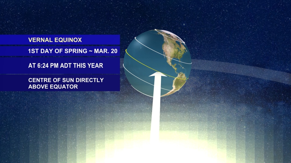
The spring (vernal) equinox arrives at 6:24 p.m. on Monday. The equinox is the time of the year when the position of the sun passes south to north over the equator.
One may think this would also be the day when there is an equal 12 hours of daylight and 12 hours of night. However, that even split between day and night actually happened a few days ago, on March 17.
The reason for the lag is due to how sunrise and sunset are defined. Sunrise is defined as when the northern edge of the sun crests the horizon, whereas sunset is defined as when the northern edge of the sun sets below the horizon.
 We arrive at the vernal equinox at 6:24 p.m. Monday, which is the astronomical definition for the start of spring.
RIVER AND FIRE WATCH PROGRAMS
With the arrival of spring, there are some river and fire watch programs now in effect.
This includes the River Watch program in New Brunswick. The temperature trend this week should be favourable for some gradual melt and weakening of the river ice, with temperatures on most days rising above freezing but falling back below at night.
Of course, the big complicating factor every year is the possibility of ice jams.
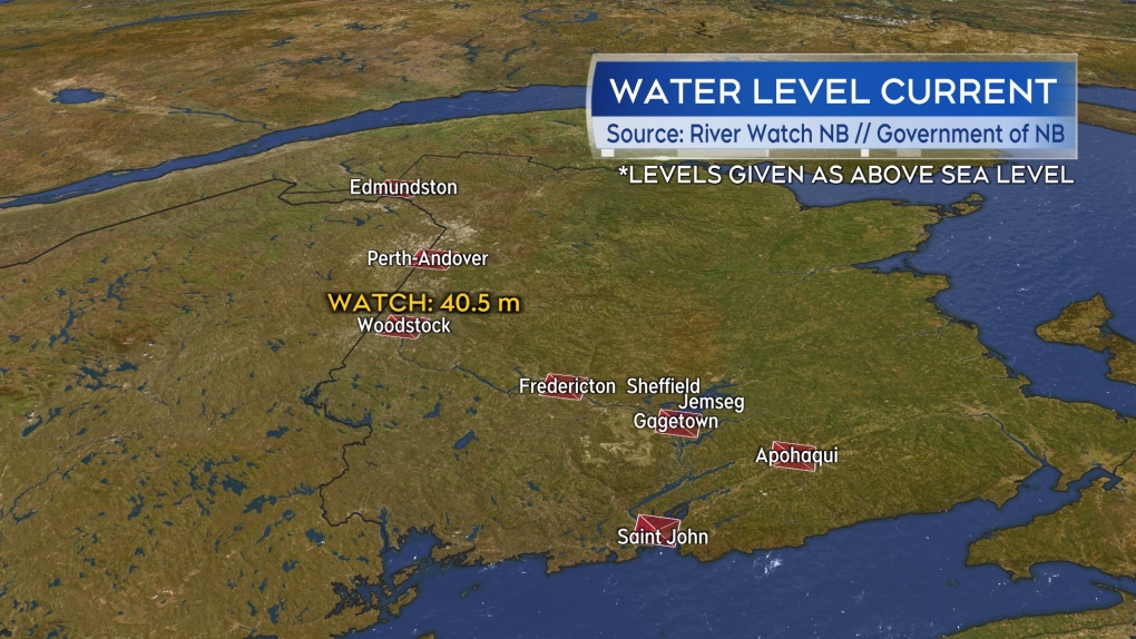
As of Monday, the only river level reporting station with a water level at watch is the station near Woodstock, N.B. The stages used by New Brunswick's River Watch include advisory, watch, warning and flood, escalating in that order.
No agricultural drought conditions are present for the Maritimes as analysed by Agriculture and Agri-Food Canada as of the end of February.
Nova Scotia and Prince Edward Island enacted their burn restriction programs on March 15. The burn restriction program for New Brunswick comes into effect on the third Monday of April, which will be April 17 this year. Burn restrictions are typically updated by the provinces at 2 p.m. each day. The programs also advise to check with municipal bylaws regarding any open fires.
 The River Watch program is running in New Brunswick. The presence of ice jams and the weather of the week are always big factors when it comes to the risk of flooding during the freshet.
AVERAGE LAST FROST
For gardeners wondering about frost, that will be a risk for sometime yet.
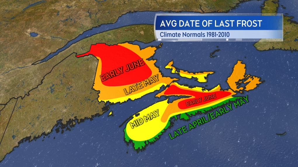
Areas of the Atlantic coast of Nova Scotia have an average date of last frost that extends from late April into early May. For much of the remainder of the Maritimes, the average date of last frost extends into mid-to-late May. There are some areas, such as the interior of northern Nova Scotia and large area of northern New Brunswick, where the average date of last frost extends into early June. That is likely the case for the Cape Breton Highlands as well, though data on average frost date is lacking for that area.
As average dates of last frost, that does mean there have been many years where a frost has happened past those times.
To get to a 10 per cent or less chance of a frost, you have to wait until early June for most of Nova Scotia and Prince Edward Island, and mid-to-late June for New Brunswick.
"I know many gardeners go by the first full moon of June. It’s not a bad rule of thumb given our frost climatology here in the Maritimes," said CTV Atlantic's Chief Meteorologist Kalin Mitchell.
"The full moon in June is early in the month this year, occurring on June 3."
 Approximate average last frost dates for the Maritimes.
SPRING WEATHER PREDICTIONS
Seasonal forecasts produced by Environment Canada have the Maritimes expecting near normal temperatures March through May, with the exception of above normal temperatures in parts of southwestern Nova Scotia.
The same predictive system has the Maritimes with below normal amounts of precipitation expected. As a comparison, a seasonal forecast system produced out of the United States has the Maritimes trending slightly towards above normal temperatures and near normal amounts of precipitation through spring.
"I’m leaning towards a spring that will finish with slightly above normal temperatures and near normal amounts of precipitation," said Mitchell.
CTVNews.ca Top Stories

Canadian team told Trump's tariffs unavoidable in short term in surprise Mar-a-Lago meeting
During a surprise dinner at Mar-a-Lago, representatives of the federal government were told U.S. tariffs from the incoming Donald Trump administration cannot be avoided in the immediate term, two government sources tell CTV News.
Toronto man accused of posing as surgeon, performing cosmetic procedures on several women
A 29-year-old Toronto man has been charged after allegedly posing as a surgeon and providing cosmetic procedures on several women.
W5 Investigates 'I never took part in beheadings': Canadian ISIS sniper has warning about future of terror group
An admitted Canadian ISIS sniper held in one of northeast Syria’s highest-security prisons has issued a stark warning about the potential resurgence of the terror group.
Trump threatens 100% tariff on the BRIC bloc of nations if they act to undermine U.S. dollar
U.S. president-elect Donald Trump on Saturday threatened 100 per cent tariffs against a bloc of nine nations if they act to undermine the U.S. dollar.
'Disappointing': Toronto speed camera cut down less than 24 hours after being reinstalled
A Toronto speed camera notorious for issuing tens of thousands of tickets to drivers has been cut down again less than 24 hours after it was reinstalled.
Poilievre suggests Trudeau is too weak to engage with Trump, Ford won't go there
While federal Conservative Leader Pierre Poilievre has taken aim at Prime Minister Justin Trudeau this week, calling him too 'weak' to engage with U.S. president-elect Donald Trump, Ontario Premier Doug Ford declined to echo the characterization in an exclusive Canadian broadcast interview set to air this Sunday on CTV's Question Period.
Bruce the tiny Vancouver parrot lands internet fame with abstract art
Mononymous painter Bruce has carved a lucrative niche on social media with his abstract artworks, crafted entirely from the colourful juices of fruits.
Why this Toronto man ran so a giant stickman could dance
Colleagues would ask Duncan McCabe if he was training for a marathon, but, really, the 32-year-old accountant was committing multiple hours of his week, for 10 months, to stylistically run on the same few streets in Toronto's west end with absolutely no race in mind. It was all for the sake of creating a seconds-long animation of a dancing stickman for Strava.
Mont-Tremblant World Cup skiing races cancelled due to warm weather
Fans hoping to see the world's top woman skiers compete next week in Mont-Tremblant, Que., are out of luck after the PwC Tremblant World Cup was cancelled due to warm weather.


