Storm moves through Northeastern U.S., heavy snow to swipe Atlantic coastal Nova Scotia
 A coastal storm on satellite imagery courtesy of the College of DuPage. The system exhibiting the comma-shaped pattern in the cloud is associated with a maturing storm.
A coastal storm continues to strengthen off the coastline of New England Tuesday afternoon.
The storm is expected to take a path south and then east of the Atlantic coastline of Nova Scotia. While not coming directly through the Maritimes, it does get close enough to possibly swipe some of the heavier snow into Atlantic coastal Nova Scotia. Snow squalls behind the storm will accumulate additional snowfall amounts for the north shore of Nova Scotia, Cape Breton Highlands, and eastern Prince Edward Island Wednesday afternoon through Thursday morning.
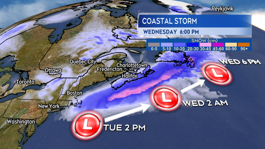 The heavy snow with the storm skirts the Atlantic coastline of Nova Scotia on the way for a more direct impact in eastern Newfoundland.
Timing
Snow develops west to east Tuesday afternoon through Tuesday evening for Nova Scotia. Not much more than some flurries are expected to brush into the south of New Brunswick and P.E.I. The snow clears western Nova Scotia before sunrise on Wednesday. The snow clears eastern areas of Nova Scotia through Wednesday morning. Snow squalls will develop off the Gulf of St. Lawrence Wednesday afternoon through Thursday morning bringing additional snow amounts to eastern P.E.I., the north shore of Nova Scotia, and Inverness/Victoria Counties of Cape Breton. Additional snow amounts in the snow squalls could range from 1 to 5 cm at lower elevations to in excess of 10 cm in more mountainous terrain.
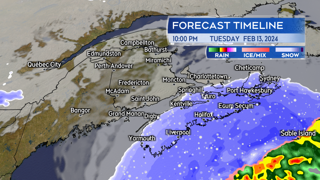 Snow will be blowing across Nova Scotia by late Tuesday evening. The snow will heaviest on the Atlantic coastline.
Snow amounts
Atlantic coastal Nova Scotia walks the razor’s edge with some of the heavier snow as the system passes through. The south shore through Halifax and up to Sydney will have the best shot of picking up snow totals of at least 15 cm. I also have Pictou, Antigonish, and Inverness/Victoria Counties in Cape Breton with 10 to 25 cm of snow, but for those areas that includes the additional snow squalls off the Gulf of St. Lawrence running through Thursday morning. Totals of more than 10 cm for those areas may be more localized, depending on how the snow squalls come in.
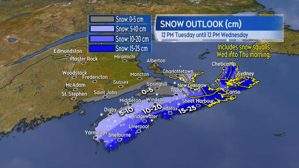 Possible snow amounts are pictured. For eastern areas of Nova Scotia and eastern Prince Edward Island, this includes additional snow squalls that could run into Thursday morning.
Wind
A northerly wind with peak gusts of 40 to 70 km/h, except up to 80 km/h on exposed areas of the Atlantic coastline of Nova Scotia, will accompany the falling snow Tuesday evening and night. The gusty wind will create periods of blowing and drifting snow. Visibility may come down to or below one-kilometre for periods of time and will improve as the snow clears.
A gusty northwest wind will continue for the Maritimes Wednesday into Thursday. That northwest wind could carry additional snow squalls off the Gulf of St. Lawrence for eastern areas of P.E.I. and eastern areas of Nova Scotia. Some flurries off the Bay of Fundy will also be possible for western Nova Scotia.
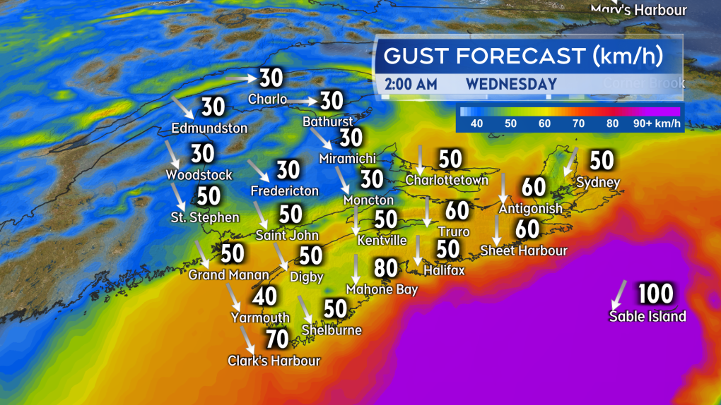 While largely below warning criteria, the wind will be gusty enough to create periods of blowing and drifting snow.
Weather alerts
A winter storm warning has been issued for Atlantic coastal Nova Scotia as well as Pictou, Antigonish, and southern Inverness Counties. A winter storm watch stands for Victoria and northern Inverness Counties in Cape Breton. No weather alerts are in effect for New Brunswick and Prince Edward Island, which are largely expected to remain out most of the inclement weather associated with the passing storm.
CTVNews.ca Top Stories

Walking pneumonia is surging in Canada. Is it peaking now?
CTVNews.ca spoke with various medical experts to find out the latest situation with the typically mild walking pneumonia in their area and whether parents should be worried.
Minister calls GST holiday, $250 cheques for 18 million Canadians 'a targeted approach'
Women and Gender Equality and Youth Minister Marci Ien is calling the federal government's proposed GST holiday and $250 rebate cheques a 'targeted approach' to address affordability concerns.
'Her shoe got sucked into the escalator': Toronto family warns of potential risk of wearing Crocs
A Toronto family is speaking out after their 10-year-old daughter's Crocs got stuck in an escalator, ripping the entire toe area of the clog off.
Prime Minister Trudeau attends Taylor Swift's Eras Tour in Toronto with family
Prime Minister Justin Trudeau is a Swiftie. His office confirmed to CTV News Toronto that he and members of his family are attending the penultimate show of Taylor Swift's 'The Eras Tour' in Toronto on Friday evening.
NEW Thinking about taking an 'adult gap year'? Here's what experts say you should know
Canadian employees are developing an appetite for an 'adult gap year': a meaningful break later in life to refocus, refresh and indulge in something outside their daily routine, according to experts.
'Immoral depravity': Two men convicted in case of frozen migrant family in Manitoba
A jury has found two men guilty on human smuggling charges in a case where a family from India froze to death in Manitoba while trying to walk across the Canada-U.S. border.
Canada Post strike could delay influencer pup's holiday cards to dozens of fans
Christmas cards are a cherished annual tradition for Percy. He sends out dozens of them every year — more than 70 last Christmas, each with a personalized message.
The Philippine vice president publicly threatens to have the president assassinated
Philippine Vice President Sara Duterte said Saturday she has contracted an assassin to kill the president, his wife and the House of Representatives speaker if she herself is killed, in a brazen public threat that she warned was not a joke.
Ancient meets modern as a new subway in Greece showcases archeological treasures
Greece's second largest city, Thessaloniki, is getting a brand new subway system that will showcase archeological discoveries made during construction that held up the project for decades.


