Tropical storm Philippe could impact the Maritimes on Thanksgiving weekend
The Maritimes have been on an extended run of very fair weather the last two weeks while under a persistent ridge of high pressure.
Unfortunately, that pattern changes this weekend with the approach of a weather front from the west and a likely post-tropical storm Philippe from the south.
The combination of weather systems is set to bring conditions that would be expected from a fall storm on Sunday.
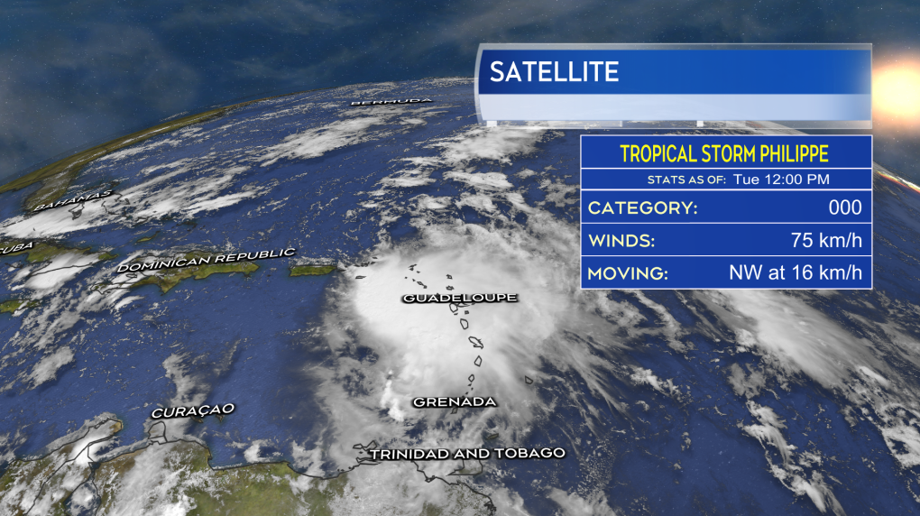
 Philippe as a tropical storm to the east of the U.S. Virgin Islands.
PHILLIPE
Tropical storm Philippe currently sits about 130 km to the east of St. Thomas in the U.S. Virgin Islands. The maximum sustained winds near the centre of the storm are estimated to be near 75 km/h. Phillipe is moving to the northwest at 16 km/h.
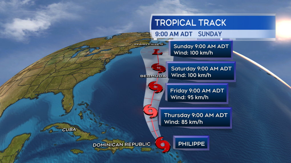
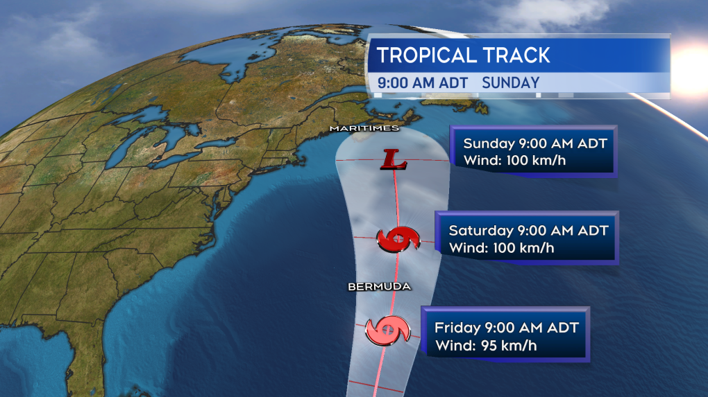
The official forecast track from the U.S. National Hurricane Center brings Philippe north into the vicinity of Bermuda as a tropical storm on Friday. Philippe is then forecast to come into the Maritimes as a post-tropical storm on Sunday. Philippe is likely to be tied up into a weather front moving in from the west, bringing the Maritimes fall storm conditions on Sunday.
 The official forecast cone for Philippe from the National Hurricane Center updated as of noon Monday, Oct. 3, 2023.
OUTLOOK
Philippe is not a Fiona or Dorian. It isn’t in the ballpark of the strength of those storms. I’d rate the storm as an 80 per cent chance of remaining tropical storm in strength and a 20 per cent chance of briefly reaching Category 1 hurricane strength as it moves north. It looks very likely it will complete a transition to a post-tropical storm before/if arriving in the Maritimes. You can think of that as the storm becoming similar to a Nor’easter, minus the snow.
It could still bring varied but impactful weather to the Maritimes on Sunday. It has at least a risk of producing some areas of rain totalling 50 mm or more. It also has a risk of producing some areas of wind gusts reaching 90 km/h or higher. The storm is still in the extended forecast and it is too early to start narrowing down areas likely to receive the heaviest rain or experience the strongest wind.
It is also too early to properly assess potential wave action brought into the Maritimes. Preliminary, it looks like less than what was seen with Lee, which would reduce the impact of coastal wash and erosion. It is also not a Full or New Moon this weekend, which means we are not at the peak of our tide cycle.
 A closer look at the forecast cone as Philippe approaches the Maritimes. The “L” designating an expected transition of the storm to post-tropical.
In summary, Philippe needs to be watched as a contribution to a period of stormy weather this weekend -- that looks most likely to be Sunday at this time. While likely post-tropical on arrival, rain and wind conditions could reach impactful levels for parts of the Maritimes.
I’ll have updates through the week on our CTV News Atlantic programming and at ctvnewsatlantic.ca.
CTVNews.ca Top Stories

W5 Investigates A 'ticking time bomb': Inside Syria's toughest prison holding accused high-ranking ISIS members
In the last of a three-part investigation, W5's Avery Haines was given rare access to a Syrian prison, where thousands of accused high-ranking ISIS members are being held.
Trudeau Liberals' two-month GST holiday bill passes the House, off to the Senate
The federal government's five-page piece of legislation to enact Prime Minister Justin Trudeau's promised two-month tax break on a range of consumer goods over the holidays passed in the House of Commons late Thursday.
Irregular sleep patterns may raise risk of heart attack and stroke, study suggests
Sleeping and waking up at different times is associated with an increased risk of heart attack and stroke, even for people who get the recommended amount of sleep, according to new research.
California man who went missing for 25 years found after sister sees his picture in the news
It’s a Thanksgiving miracle for one California family after a man who went missing in 1999 was found 25 years later when his sister saw a photo of him in an online article, authorities said.
As Australia bans social media for children, Quebec is paying close attention
As Australia moves to ban social media for children under 16, Quebec is debating whether to follow suit.
Notre Dame Cathedral: Sneak peak ahead of the reopening
After more than five years of frenetic reconstruction work, Notre Dame Cathedral showed its new self to the world Friday, with rebuilt soaring ceilings and creamy good-as-new stonework erasing somber memories of its devastating fire in 2019.
Canada Post temporarily laying off striking workers, union says
The union representing Canada Post workers says the Crown corporation has been laying off striking employees as the labour action by more than 55,000 workers approaches the two-week mark.
Can't resist Black Friday weekend deals? How to shop while staying within your budget
A budgeting expert says there are a number of ways shoppers can avoid getting enveloped by the sales frenzy and resist spending beyond their means.
Montreal shopping mall playing 'Baby Shark' song to prevent unhoused from loitering
A shopping mall and office complex in downtown Montreal is being criticized for using the popular children's song 'Baby Shark' to discourage unhoused people from loitering in its emergency exit stairwells.


