Weather warnings issued as mix of snow, ice pellets, and rain expected for Tuesday in the Maritimes
 A pedestrian makes their way through wind and sleet in Halifax, Wednesday, Jan. 10, 2024. THE CANADIAN PRESS/Darren Calabrese
A developing low-pressure system, moving up from the coastline of New England, will bring a mix of snow, ice pellets, and rain to the Maritimes Tuesday afternoon into early Wednesday morning.
TIMING
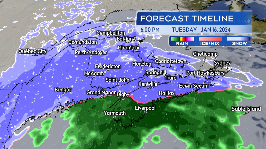
There is a chance of some light snow or flurries on the South Shore of Nova Scotia Tuesday morning, with a turn from snow to rain expected for most of the province by early evening. For the rest of the Maritimes, snow will develop Tuesday afternoon into early evening and a turn from snow to rain is expected throughout the evening for the Bay of Fundy areas of New Brunswick and Prince Edward Island.
Most of the snow and rain will end in the very early morning hours of Wednesday. There will be a chance of flurries and possible icy conditions as temperatures return below freezing on Wednesday.
 Snow develops across the Maritimes Tuesday afternoon into evening. Snow turning to rain for all but the northern half of New Brunswick through Tuesday evening.
SNOW AND RAIN AMOUNTS
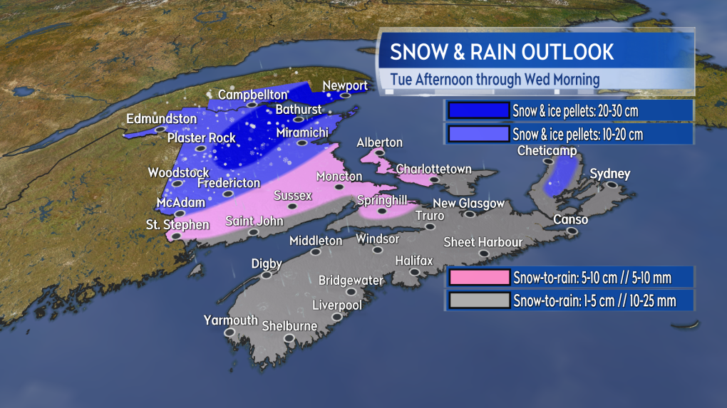
Fredericton and northern New Brunswick will see the most snow and ice pellets, with 10 to 20 cm of accumulation. Snowfall warnings have been issued in the province. The Cape Breton Highlands could also pick up 10 to 20 cm. The rest of the Maritimes will get less than 10 cm of snow, followed by 10 to 25 mm of rain.
 The most widespread amounts of 10 to 20 cm are expected Fredericton and north in New Brunswick.
WIND
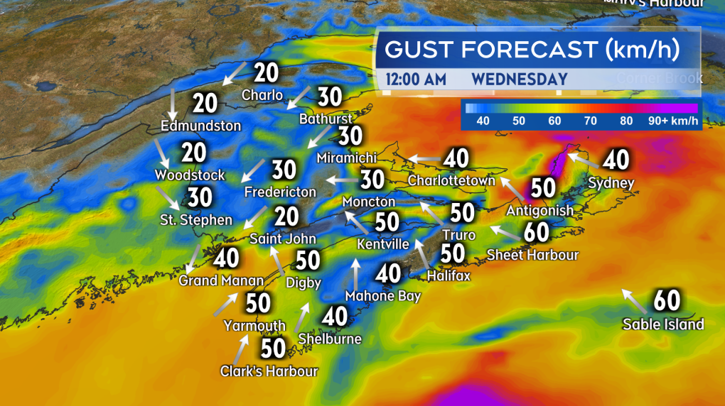
The wind is not expected to match up to the two previous storms. Southeasterly gusts will reach a peak of 40 to 60 km/h for Nova Scotia and Prince Edward Island Tuesday evening and night. Easterly gusts will peak at 20 to 40 km/h for New Brunswick. Due to the topography of the Cape Breton Highlands, gusts in northern Inverness County could peak near 100 km/h Tuesday night before diminishing by Wednesday morning.
 While gusty for Nova Scotia and PEI the wind speeds don’t look like they will match up to the two previous storm systems.
ICE ON WEDNESDAY
Temperatures will rise above freezing for a large area of Nova Scotia, Prince Edward Island, and parts of southern New Brunswick Tuesday evening and night. The rise in temperature will be accompanied by the turn from snow to rain. Temperatures for those areas will fall back below freezing Wednesday morning through Wednesday afternoon. Wet or slushy surfaces could turn icy during that time.
CTVNews.ca Top Stories

W5 Investigates 'I never took part in beheadings': Canadian ISIS sniper has warning about future of terror group
An admitted Canadian ISIS sniper held in one of northeast Syria’s highest-security prisons has issued a stark warning about the potential resurgence of the terror group.
'Absolutely been a success': Responders looks back at 988, Canada's Suicide Crisis Helpline, one year later
In its first year, responders for Canada's Suicide Crisis Helpline, known as 988, have answered more than 300,000 calls and texts in communities nationwide.
Prime Minister Trudeau meets Donald Trump at Mar-a-Lago
Prime Minister Justin Trudeau landed in West Palm Beach, Fla., on Friday evening to meet with U.S.-president elect Donald Trump at Mar-a-Lago, sources confirm to CTV News.
Nova Scotia PC win linked to overall Liberal unpopularity: political scientist
Nova Scotia Premier Tim Houston is celebrating his second consecutive majority mandate after winning the 2024 provincial election with 43 seats, up from 34. According to political science professor Jeff MacLeod, it's not difficult to figure out what has happened to Liberals, not just in Nova Scotia but in other parts of Canada.
'Mayday! Mayday! Mayday!': Details emerge in Boeing 737 incident at Montreal airport
New details suggest that there were communication issues between the pilots of a charter flight and the control tower at Montreal's Mirabel airport when a Boeing 737 made an emergency landing on Wednesday.
Hit man offered $100,000 to kill Montreal crime reporter covering his trial
Political leaders and press freedom groups on Friday were left shell-shocked after Montreal news outlet La Presse revealed that a hit man had offered $100,000 to have one of its crime reporters assassinated.
Questrade lays off undisclosed number of employees
Questrade Financial Group Inc. says it has laid off an undisclosed number of employees to better fit its business strategy.
Cucumbers sold in Ontario, other provinces recalled over possible salmonella contamination
A U.S. company is recalling cucumbers sold in Ontario and other Canadian provinces due to possible salmonella contamination.
Billboard apologizes to Taylor Swift for video snafu
Billboard put together a video of some of Swift's achievements and used a clip from Kanye West's music video for the song 'Famous.'


