Wind chill explained and what to expect late this week in the Maritimes
There is going to be a lot of weather talk about wind chill in the Maritimes Friday night into Saturday. A blast of Arctic air will combine with what are expected to be northwest gusts of 60 to 80 km/h Friday night into Saturday to produce a wind chill making it feel -35 degrees or colder for parts of all three Maritime provinces. A wind chill making it feel -35 or colder for two or more hours is the criteria for an extreme cold warning in the Maritimes. Nova Scotia and P.E.I. haven’t had an extreme cold warning since 2015. The last one issued in New Brunswick was Jan 31-Feb 1, 2022.
So what is wind chill and why does it matter?
Our bodies lose heat to colder air via convection, which is the primary mechanism of heat transfer in gases such as our atmosphere. When we step outside into colder air, we immediately start to lose heat from exposed skin at a high rate. After a period of time, a thin, insulating layer of air develops near our skin and while we continue to lose body heat the rate at which that happens slows.
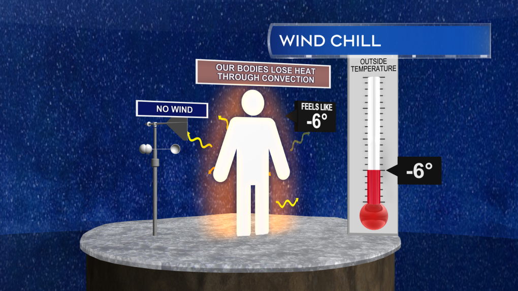 Without wind present, a thin, insulating layer of air forms near our skin as we lose body heat to colder air.
If wind is present, it will continuously disrupt or blow away that thin, insulating layer or air. That keeps the rate of heat loss from our body at a higher rate. Wind chill is a calculation of what the air temperature would have to be in order to have that higher rate of heat loss without the wind present. In the example I’m showing here, it would take a calculated air temperature of -14 C with no wind to replicate the expected rate of heat loss with an air temperature of -6 C and a 30 km/h wind. If you’d like to explore wind chill calculations for different temperatures and wind speeds, you can do so here.
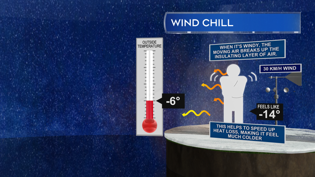 With wind present, the thin, insulating layer of air is continuously disrupted, increasing the rate of heat loss to the environment. The equivalent air temperature without any wind that would match that rate of heat loss is known as wind chill.
As for why wind chill matters: At wind chill values making it feel -28 or colder there is an increased risk of frostbite to exposed skin. With a wind chill of -28 to -39 exposed skin can freeze in 10 to 30 minutes. With a wind chill of -40 to -47 that freeze can take place in as little as 5 to 10 minutes. Hypothermia is of course also a risk in that type of cold, unless properly dressed as well. You can find a detailed breakdown of the health hazards associated with extreme cold and wind chill here.
It’s Canada, it’s winter, we get cold, so why all the weather talk? Well, this combination of Arctic air and wind is more extreme than what we have to typically content with. The low temperatures Friday night into Saturday morning may be enough to challenge some of the longer-standing records for cold for a Feb. 4 in the Maritimes. The National Weather Service office in Caribou, Maine, also noted in a discussion that the air temperature aloft in the atmosphere at a height of 1,500 metres may challenge the standing record they have in more than 70 years of recorded data from weather balloon launches at the site. That standing record is -39.4 C with some of the current forecast guidance suggesting it could be -40 C or colder this Friday night at that height in the atmosphere.
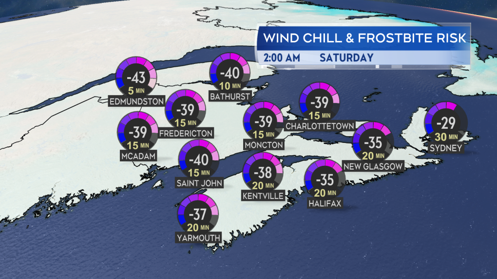 Forecast guidance into potential wind chill in the Maritimes Friday night into Saturday morning.
Our surface temperatures won’t match up to that colder air aloft. However, as mentioned above, the wind chill does look like it will approach the warning criteria. Below you can find a map with some guidance on possible wind chill values as we move into early Saturday morning. The wind chill is expected to be particularly bad in northern areas of New Brunswick. Remember that those wind chill values are calculated off of expected air temperature and wind speed. Should we get a change in the expected conditions the wind chill will change as well.
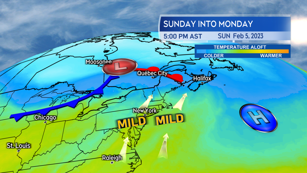 A southerly wind will setup between high pressure to the east and low pressure to the west Sunday into Monday. That will return milder air up the U.S. eastern seaboard and into the Maritimes.
Thankfully, this snap of cold is not a long duration event. We will be in the worst of the cold Friday night through Saturday. Temperatures and wind chill moderate through the day Sunday into Monday. That happens as a southerly wind develops and returns milder air from the U.S. eastern seaboard.


CTVNews.ca Top Stories

Which Canadian cities have the highest and lowest grocery prices?
Where you live plays a big factor in what you pay at the grocery store. And while it's no secret the same item may have a different price depending on the store, city or province, we wanted to see just how big the differences are, and why.
BREAKING
BREAKING McGill University seeks emergency injunction to remove pro-Palestinian encampment from campus
McGill University has filed a request for an injunction to have the pro-Palestinian encampment removed from its campus.
Swarm of 20,000 bees gather around woman’s car west of Toronto
A swarm of roughly 20,000 bees gathered around a woman’s car in the parking lot of Burlington Centre.
U.S. says Israel's use of U.S. arms likely violated international law, but evidence is incomplete
The Biden administration said Friday that Israel's use of U.S.-provided weapons in Gaza likely violated international humanitarian law but wartime conditions prevented U.S. officials from determining that for certain in specific airstrikes.
'State or state-sponsored actor' believed to be behind B.C. government hacks
The head of British Columbia’s civil service has revealed that a “state or state-sponsored actor” is behind multiple cyber-security incidents against provincial government networks.
Mother assaulted by stranger while breastfeeding baby in her car: Vancouver police
A person was arrested in East Vancouver Thursday after allegedly entering a car while a mother was breastfeeding her four-month-old boy.
Rare severe solar storm Friday could bring spectacular aurora light show across Canada
A rare and severe solar storm is expected to bring spectacular displays of the northern lights, also known as aurora borealis, across much of Canada and parts of the United States on Friday night.
More than half the Canadians once detained in Syrian camps for suspected ISIS family members have returned home
A total of 29 Canadians have been freed from detention camps in northeast Syria and brought back to Canada since human rights advocates began lobbying for their release years ago.
Canada abstains from Palestinian UN membership vote but supports two-state solution
Canada was one of 25 countries that abstained from a United Nations vote on Palestinian membership that passed with overwhelming support on Friday.
Shopping Trends
The Shopping Trends team is independent of the journalists at CTV News. We may earn a commission when you use our links to shop. Read about us.


Toronto
-

Where and when to see the northern lights in Toronto tonight
The northern lights, also known as aurora borealis, are expected to illuminate the sky in Canada tonight, including in Toronto, thanks to a rare and severe solar storm.
-
Swarm of 20,000 bees gather around woman’s car west of Toronto
A swarm of roughly 20,000 bees gathered around a woman’s car in the parking lot of Burlington Centre.
-
Vehicle strikes bus shelter in Bridle Path, leaving man in life-threatening condition
A vehicle struck a bus shelter in Bridle Path on Friday afternoon, leaving a man in life-threatening condition.
Calgary
-

City of Chestermere inspection reveals ‘irregular, improper and improvident’ financial management: province
A third-party examination of the City of Chestermere revealed “significant gaps” in the financial management, the province said Friday.
-
'We have laws': Premier Smith says police action justified in Calgary
The actions, including the decision to use non-lethal force, to disperse pro-Palestinian protesters from the University of Calgary campus were justified, Alberta Premier Danielle Smith said Friday.
-
Calgary approves all 28 recommendations from downtown safety panel
The City of Calgary has approved more than two-dozen recommendations to improve safety and vibrancy in the downtown core.
Edmonton
-

'Violent, despicable and unbelievable': Family of murdered 7-year-old speak at David Moss sentencing Friday
David Moss, the man who murdered seven-year-old Bella Rose Desrosiers, broke down in court Friday as the girl's family spoke about the toll her death has taken on them.
-
Oilers star Leon Draisaitl questionable for Game 2 vs. Canucks
Edmonton Oilers star Leon Draisaitl is questionable for today's Game 2 against the Vancouver Canucks.
-
Out-of-control wildfire burning near Fort McMurray
As of 9 a.m. on Friday, the wildfire burning 28 kilometres southwest of the northeastern Alberta city was 25 hectares in size.
Montreal
-
 BREAKING
BREAKING McGill University seeks emergency injunction to remove pro-Palestinian encampment from campus
McGill University has filed a request for an injunction to have the pro-Palestinian encampment removed from its campus.
-
Man charged after truck strikes and kills driver changing flat tire on side of Montreal-area highway
A 43-year-old man has been charged after a driver was struck and killed while changing a tire on the side of a Highway 15 near Montreal on Thursday.
-
This iconic Canadian song is turning 50
Andy Kim's 'Rock Me Gently' is marking a major milestone, as it celebrates its 50th anniversary.
Ottawa
-

Motorcycle driver in critical condition after crash in Barrhaven
Ottawa paramedics say a man in his 20s is in critical condition after a crash in Barrhaven Friday afternoon.
-
Tiny house show to takes place Sunday in Ottawa
In the midst of soaring living expenses and spiking interest rates, the dream of owning a traditional home seems to be slipping away for many residents in Ottawa.
-
'The whole community is devastated': Sharbot Lake, Ont. mourning the death of teen in crash
A high school student at Granite Ridge Education Centre in Sharbot Lake, Ont. died in a single-vehicle crash on Thursday. Five other students were injured in the crash.
London
-

Suspicious fire being investigated in London
A suspicious fire in London is under investigation by police and fire officials. According to London fire, crews knocked down the scene in an “offensive strategy.”
-
Lambton County teen dies in farm accident
OPP in Lambton County are investigating what is being described as a, “sudden death.” Police responded to the call at a farm on Churchill Line in Watford around 9:30 a.m.
-
Sarnia police searching for stabbing suspect
The Sarnia Police Service has issued a warrant for a 30-year-old female in connection to a stabbing incident.
Barrie
-

Barrie men charged with fraud in OPP investigation into pool installation scam
Two Barrie men have been charged with fraud in connection with a lengthy OPP investigation after several customers seeking pool installations were allegedly scammed out of thousands of dollars.
-
Wasaga Beach assault turns into murder investigation after victim's death
The charge against a Wasaga Beach man has been upgraded to second-degree murder after police say the victim died more than two months after an alleged assault.
-
Here's why your yard waste may have been sitting at the curb for days
A recent change in curbside collection has left some green-thumbed enthusiasts scratching their heads as bags of yard waste linger by the curb, awaiting pickup.
Northern Ontario
-

Dashcam video shows terrifying near-miss on two-lane northern Ontario highway
There were some scary moments for several people on a northern Ontario highway caught on video Thursday after a chain reaction following a truck fire.
-
Twenty defendants fined $222K for northern Ont. moose hunt violations
A large group of Canadian and U.S. defendants have been fined $178,400 plus $44,525 in surcharges for a variety of moose hunting violations in northwestern Ontario.
-
Radical anti-government rhetoric appears in northern Ont. court case
A northern Ontario couple who ran afoul of Ontario’s building code used arguments reminiscent of radical anti-government groups in a failed attempt to defend their stance in court.
Kitchener
-

'A total write-off': Kitchener resident asks for thousands from city, after driving over 'faulty manhole cover
One driver wants the City of Kitchener to cover the thousands of dollars in damage to his car after he ran over a “faulty” manhole cover.
-
What you should keep in your emergency supply kit
Could you survive for 72 hours following a natural disaster? The Region of Waterloo is hoping that question sparks a conversation around emergency preparedness.
-
9-year-old prodigy pianist to perform with former K-W Symphony musicians
A young prodigy pianist is set to perform alongside former members of the Kitchener-Waterloo Symphony, as part of a benefit concert.
Windsor
-

Windsor’s unemployment rate jumps back into highest in Canada
The unemployment rate in Windsor increased dramatically last month and is the highest in Canada, according to Statistics Canada.
-
City of Windsor has unanswered questions as feds, province spar over housing funding
A dispute between the federal and provincial governments over the National Housing Strategy nearly put the City of Windsor $7 million in the hole and questions still remain over when and how much funding the city will receive.
-
Highway 401 ramps at Queens Line closed after crash
OPP are informing the public of a crash on the Highway 401 ramps at Queens Line in Chatham-Kent.
Winnipeg
-

'Devastating': Businesses concerned over watercraft ban on Clear Lake
Businesses in the Clear Lake area are concerned about the future following a temporary ban on watercraft from entering the lake.
-
Roughly 250 people forced to evacuate Winnipeg apartment building deemed unsafe
Approximately 250 residents of a St. James area apartment building will have to leave their homes immediately, as the City of Winnipeg issued a vacate order over unsafe conditions.
-
Solar storm could produce highly visible northern lights in Manitoba
An unusually large solar storm could produce northern light shows that may be visible across most of Canada on Friday and Saturday.
Regina
-

Sask. teachers set to vote on renewed sanctions mandate
Next week, teachers in Saskatchewan will vote on a renewed mandate that would implement sanctions beyond the current school year.
-
Regina police charge 3, seize drugs, ammunition after 'months long investigation'
Regina police say three people have been charged after they seized more than 1,100 grams of a substance believed to be cocaine along with suspected meth and ammunition following a “months long investigation.”
-
Which Canadian cities have the highest and lowest grocery prices?
Where you live plays a big factor in what you pay at the grocery store. And while it's no secret the same item may have a different price depending on the store, city or province, we wanted to see just how big the differences are, and why.
Saskatoon
-
Sask. teachers set to vote on renewed sanctions mandate
Next week, teachers in Saskatchewan will vote on a renewed mandate that would implement sanctions beyond the current school year.
-
Saskatoon police respond to collision involving pedestrian
Saskatoon police are responding to a collision involving a vehicle and a pedestrian near the intersection of 8th Street and Arlington Avenue.
-
Nutrien CEO wants fully automated or tele-remote operations in all 6 mines
Improved mine automation helped fertilizer giant Nutrien Ltd. increase potash production in the first quarter amid strong demand for its products, the company's chief executive said.
Vancouver
-

'State or state-sponsored actor' believed to be behind B.C. government hacks
The head of British Columbia’s civil service has revealed that a “state or state-sponsored actor” is behind multiple cyber-security incidents against provincial government networks.
-
Suspect fled in 2-door Fiat after convenience store robbery, Merritt RCMP say
A suspect is at large after robbing a convenience store at gunpoint in Merritt, B.C., Friday, according to local police.
-
B.C. finance minister says she will retire following provincial election this fall
British Columbia's finance minister says she won't be running again in the next provincial election after serving in the legislature for nearly two decades.
Vancouver Island
-

Police launch assault investigation at UVic protest encampment
Police in Saanich, B.C., say an assault investigation is underway following two alleged incidents at a pro-Palestinian protest encampment on the grounds of the University of Victoria.
-
Victoria police searching for man accused of voyeurism in downtown store
Police in Victoria are appealing to the public to identify a man who allegedly took photos or video of a woman in a change room at a downtown store Wednesday afternoon.
-
Vancouver robbery suspect facing 12 charges after businesses targeted
A 29-year-old man is facing a dozen robbery charges after a months-long string of burglaries at Vancouver businesses.
Kelowna
-

Suspect fled in 2-door Fiat after convenience store robbery, Merritt RCMP say
A suspect is at large after robbing a convenience store at gunpoint in Merritt, B.C., Friday, according to local police.
-
Kamloops RCMP issue public warning about 2 men allegedly at centre of 'organized crime conflict'
After four targeted shootings in four days, Mounties in Kamloops are taking the unusual step of warning the public about two men they believe are likely to be targeted in future violent incidents.
-
Community mourns thousands of fish lost as B.C. drought risk looms again
Images of steelhead and trout flicker over long sheets of paper, brought to life in blue and green crayon rubbings by the thousands.


