Wind warnings as stormy end to November brings risk of power outages in Maritimes
 Waves pound the shore in Peggy's Cove, N.S., on Tuesday, Sept. 22, 2020. (THE CANADIAN PRESS/Andrew Vaughan)
A powerful weather front associated with a low centred in northern Quebec will sweep across the Maritimes Wednesday night into Thursday.
The front will drive a strong pressure gradient in front of it which will in turn create a high and gusty southerly wind. Peak gusts of 60 to 90 km/h will arrive in western New Brunswick and southwestern Nova Scotia by late Wednesday evening.
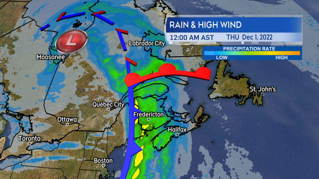 A cold front out of the west brings a rainy and windy close to the month of November.
Overnight the strong wind will shift to eastern New Brunswick, eastern Nova Scotia, and Prince Edward Island. Peak gusts at higher terrain and exposed areas of the coast could hit 100 km/h. Gusts in northern Inverness County, Cape Breton could reach 130 km/h Sunday morning due to the topography of the Highlands.
The strong wind gusts could cause isolated power outages and damage holiday decorations.
Marine Atlantic has an advisory out saying that the North Sydney, N.S., to Port aux Basque, N.L., ferry travel could be impacted Wednesday night and Thursday. The Confederation Bridge is advising that traffic restrictions may be in effect Wednesday night into Thursday morning.
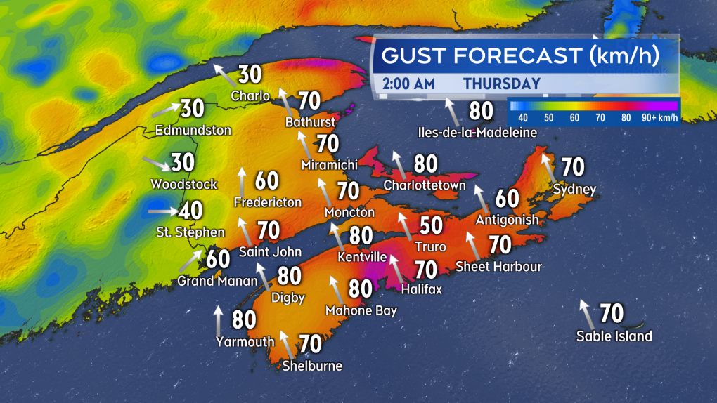 Southerly winds peak with gusts 60 to 90 km/h late Wednesday night and early Thursday morning. Exposed areas of the coast could hit as high as nearly 100 km/h.
Thursday morning, the wind becomes west with gusts coming down into a range of 40 to 60 km/h for all except Cape Breton.
Cape Breton will remain in the strong south wind until early Thursday afternoon after which the switch to the west wind will take place. The west wind will return colder air to the Maritimes and temperatures Thursday night and Friday will be chilly again.
This will be the 4th high-wind event of the month. The three previous occurred on Nov. 8, Nov. 12, and Nov. 26. In this case I’m defining a high wind event as one that brought widespread gusts of 70+ km/h to the region.
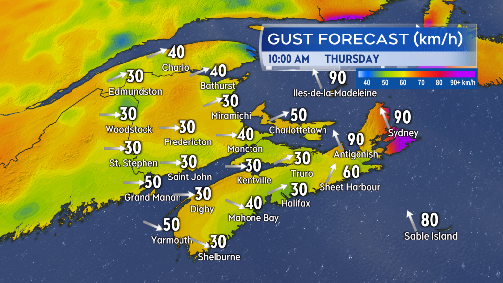 Winds turn west and diminish Thursday morning except for Cape Breton which will see the change happen Thursday afternoon. The west wind will be gusty and bring colder air back into the region.
There is no need for snow shovels with this event. While some initial snow will fall in northern New Brunswick, a turn to rain is expected Wednesday evening.
Rain will total 10 to 40 mm for much of the Maritimes. Higher amounts of 40 to 60 mm are possible near the Bay of Fundy coastline in New Brunswick, the Atlantic coastline of Nova Scotia, and in Cape Breton.
Higher rainfall rates will contribute to some ponding water on roadways and reduce visibility. The rain develops Wednesday evening and night. The rain clears west-to-east Thursday morning into early Thursday afternoon.
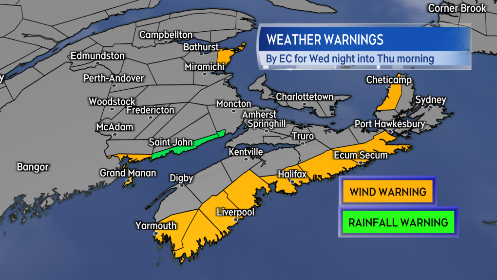 Wind and Rain Warnings have been issued for parts of the Maritimes. The remainder of the region is under a Special Weather Statement.
As of Tuesday afternoon, a Rainfall Warning has been issued for the Bay of Fundy coastline of New Brunswick. Wind Warnings are in effect for the South Shore, Halifax County, and Eastern Shore of mainland Nova Scotia as well as northern Inverness County, Cape Breton.
A Special Weather Statement remains in effect for the remainder of the region advising the public to monitor the forecast in the event further warnings are issued.


CTVNews.ca Top Stories

NEW
NEW From yearning for a change to cost of living, why some Canadians have left or may leave the country
For some immigrants, their dreams of permanently settling in Canada have taken an unexpected twist.
NEW
NEW Capital gains tax change 'shortsighted' and 'sows division' business groups tell Freeland
Forging ahead with increasing Canada's capital gains inclusion rate 'sows division,' and is a 'shortsighted' way to improve the deficit, business groups are warning Finance Minister Chrystia Freeland.
Minister said 'hundreds' of Canadians might use Gaza visa. More than 7,500 applied.
An immigration lawyer in Toronto says new figures from the federal government show just how 'grudging' Ottawa's efforts have been to rescue Canadians' family members from the war in the Gaza Strip.
Police handcuff man trying to enter Drake's Toronto mansion
Toronto police say a man was taken into custody outside Drake's Bridle Path mansion Wednesday afternoon after he tried to gain access to the residence.
Canucks claw out 5-4 comeback win over Oilers in Game 1
Dakota Joshua had a goal and two assists and the Vancouver Canucks scored three third-period goals to claw out a 5-4 comeback victory over the Edmonton Oilers in Game 1 of their second-round playoff series Wednesday.
U.S. presidential candidate RFK Jr. had a brain worm, has recovered, campaign says
Independent U.S. presidential candidate Robert F. Kennedy Jr. had a parasite in his brain more than a decade ago, but has fully recovered, his campaign said, after the New York Times reported about the ailment.
What is whooping cough and should Canadians be concerned as Europe declares outbreak?
There is currently a whooping cough epidemic in Europe, with 10 times as many cases compared to the previous two years. While an outbreak has not been declared nationwide in Canada, whooping cough is regularly detected in the country.
Florida deputies who fatally shot U.S. airman burst into wrong apartment, attorney says
Deputies responding to a disturbance call at a Florida apartment complex burst into the wrong unit and fatally shot a Black U.S. Air Force airman who was home alone when they saw he was armed with a gun, an attorney for the man's family said Wednesday.
'A beautiful soul': Funeral held for baby boy killed in wrong-way crash on Highway 401
A funeral was held on Wednesday for a three-month-old boy who died after being involved in a wrong-way crash on Highway 401 in Whitby last week.
Shopping Trends
The Shopping Trends team is independent of the journalists at CTV News. We may earn a commission when you use our links to shop. Read about us.


Toronto
-

Free parking and mortgage holidays: Developers offering new incentives as Toronto preconstruction condo sales plummet
As preconstruction condo sales in Toronto plummet to levels not seen since the global financial crisis 15 years ago, developers are now turning to more lucrative incentives to try to entice prospective buyers.
-
Ontario man frustrated after $3,500 paving job leaves driveway in shambles
An Ontario man considering having his driveway paved received a quote from a company for $7,000, but then, another paver in the neighbourhood knocked on his door and offered half that rate.
-
Systemic failure to promote Black officers under microscope as superintendent apologizes for helping racialized police cheat
In emotional and raw testimony at a disciplinary tribunal, the first Black female superintendent in the Toronto Police Service apologized for helping racialized constables cheat a promotional exam.
Calgary
-

Building boost? Province boasts Bill 20 changes; Calgary mayor says it won't do much
As Calgary continues to battle a housing crisis, the province is rolling out changes it says will help.
-
Calgary family physician charged with sexual assault of Cowboys patron
A Calgary family physician is accused of sexually assaulting a woman more than a year ago.
-
'Only representative of the folks that show up': Few Albertans aware of public consultation
One hundred and sixteen of the Alberta government's 192 ongoing consultations seek public input on topics ranging from how the province should spend money to where trails should be built in parks.
Edmonton
-

Canucks score four unanswered goals to edge Oilers in Game 1 of series
Conor Garland's snapshot with five-and-a-half minutes left in the third period capped a three-goal run in a five-minute span, lifting the Vancouver Canucks to a 5-4 win over the Edmonton Oilers in Game 1 of their second-round National Hockey League playoff series.
-
Size of Vancouver Island burned in 2023 Alberta wildfires: ABMI report
A group of researchers who studied the historic 2023 Alberta wildfires calls them “remarkable” at least in recent history.
-
Elks report net loss of $3.9M for 2023 as team narrows list of potential new owners
While the Green and Gold are bleeding even more red ink, shareholders of Edmonton's Canadian Football League franchise heard Wednesday at its annual general meeting there's hope on the horizon.
Montreal
-

Quebec's birth rate dips to lowest level in nearly 20 years
Quebec saw a 3 per cent drop in the number of births between 2022 and 2023, according to data released Wednesday by the Institut de la statistique du Québec (ISQ).
-
English CEGEPs' struggles with Bill 96 requirements show why language law is needed: minister
Quebec's minister for the French language says if English CEGEPs are having a problem with the new French-language exam for students, it only shows that the province's language laws are necessary.
-
Toronto FC beats semi-pro side CS Saint-Laurent 3-0 in Canadian Championship
Matty Longstaff broke a deadlock in the 50th minute and Toronto FC went on to defeat semi-pro side CS Saint-Laurent 3-0 in the opening leg of their Canadian Championship quarterfinal on Wednesday.
Ottawa
-
 NEW THIS MORNING
NEW THIS MORNING How to deal with rats on your property
Residents in Ottawa’s Elmridge Gardens complex are dealing with an unprecedented rat infestation and are asking the city to step in and help.
-
Sunny and warm Thursday in the forecast for Ottawa
The sunshine returns to Ottawa today, but rain in the forecast may dampen Mother's Day activities this weekend.
-
'Summer of discontent': Federal unions vow to fight new 3-day a week office mandate
Federal unions are launching legal challenges and encouraging public sector workers to file "tens of thousands" of grievances over the new mandate requiring federal workers to return to the office at least three days a week in the fall.
London
-

More than 150 townhomes in northeast London have lost mail service due to off-leash dog
‘It’s a rough situation.’ Townhome residents on Briarhill Avenue have been without mail delivery for about two months.
-
One person in custody after heavy police presence in Ingersoll
One person has been taken into custody following a police presence near Ingersoll on Wednesday night. Police had surrounded a motel for what was described as an, "investigation in relation to a wanted party."
-
Does council deserve another pay increase? Compensation review being considered
Council is responsible for setting its own financial compensation, and next week they may reopen several politically charged issues related to their pay cheques.
Barrie
-

Youth pedestrian struck by alleged drunk driver in Owen Sound
A 14 year old in Owen Sound is recovering from injuries after being struck by a vehicle that fled the scene.
-
Barrie business owner fed up over repeated break-ins since opening
A small business owner in Barrie is fed up after his establishment has been the target of crime multiple times since opening in 2019.
-
Crown seeks 6 years jail time for Barrie woman guilty of impaired driving causing bodily harm
An emotional Cassie Korzenko walked into the Barrie Courthouse Wednesday morning with family members by her side ahead of a sentencing hearing.
Northern Ontario
-

Seven northern Ont. men busted in huge online child exploitation investigation
A province-wide child sexual abuse investigation by Ontario Provincial Police dubbed Project Aquatic has resulted in hundreds of charges, including seven male suspects from northern Ontario.
-
'Ozempic babies': Reports of surprise pregnancies raise new questions about weight loss drugs
Numerous women have shared stories of 'Ozempic babies' on social media. But the joy some experience in discovering pregnancies may come with anxiety about the unknowns.
-
Ontario man devastated to learn $150,000 line of credit isn't insured after wife dies
An Ontario man found out that a line of credit he thought was insured actually isn't after his wife of 50 years died.
Kitchener
-

One person in custody after heavy police presence in Ingersoll
One person has been taken into custody following a police presence near Ingersoll on Wednesday night. Police had surrounded a motel for what was described as an, "investigation in relation to a wanted party."
-
Police search for missing child from Waterloo
Waterloo regional police are asking for help finding a missing child from Waterloo.
-
'The bins aren’t appropriate': Residents react to Waterloo Region’s proposed waste collection program
A pricey plan, proposed by staff for the Region of Waterloo, would see a new fleet of garbage trucks and carts replace bags.
Windsor
-

Meet and greet benefits local sports tourism
Sports tourism is a major draw in Windsor-Essex and community and organizations huddled to come up with a specific game plan.
-
'Predators go where children go': 5 local people arrested, charged through Project Aquatic
Four people from Windsor, one of whom is 16 years old, and one person from Chatham are now charged with offences including possessing, accessing and making available child pornography.
-
'I wouldn’t trade it for anything': Caesars Windsor celebrates 30 years in the community
To celebrate their 30-year presence in the Windsor community, Caesars Windsor employees are rolling up their sleeves this week, volunteering at six local non-profit organizations.
Winnipeg
-
'I killed four people': Trial hears video evidence of Jeremy Skibicki at Winnipeg trial
“I killed four people,” alleged serial killer Jeremy Skibicki told two homicide detectives during a recorded interview played as evidence in his trial Wednesday.
-
Proposed class-action lawsuit launched against Manitoba government for use of solitary confinement in prisons
A proposed class-action lawsuit has been filed against the Manitoba government by a previous inmate for the use of solitary confinement, calling the practice, "cruel, inhumane, and degrading treatment."
-
Grab your gear: Camping season set to kick off in Manitoba
Get your gear ready – camping season has officially arrived in Manitoba.
Regina
-

Here's a complete timeline of the Saskatchewan teachers labour dispute
The dispute between Saskatchewan educators and the province is rapidly approaching one year in length. It's a fight that's seen a war of words waged over social media, teachers battling extreme cold on the picket line and massive disruptions for the province's student population.
-
Sask. parents of autistic children denounce lack of specialized learning in schools
Parents of children with autism joined MLAs in the legislature on Wednesday to rally against cuts for specialized learning in schools.
-
Fort Qu'Appelle high school students hold smudge walk to honour MMIWG
On Monday, students from Bert Fox Community High School led a smudge walk through Fort Qu’Appelle to bring awareness to missing and murdered Indigenous women and girls.
Saskatoon
-
Here's a complete timeline of the Saskatchewan teachers labour dispute
The dispute between Saskatchewan educators and the province is rapidly approaching one year in length. It's a fight that's seen a war of words waged over social media, teachers battling extreme cold on the picket line and massive disruptions for the province's student population.
-
Sask. barista prepares to roast competitors at national coffee competition
A competitor from Saskatoon is heading to Vancouver for a competition that promises to be quite the grind.
-
'Written off': Sask. woman says her brother, who had Down syndrome, fell through the cracks
Tara Jo Kadlec has been advocating for better care for her brother Cory for years.
Vancouver
-

Canucks claw out 5-4 comeback win over Oilers in Game 1
Dakota Joshua had a goal and two assists and the Vancouver Canucks scored three third-period goals to claw out a 5-4 comeback victory over the Edmonton Oilers in Game 1 of their second-round playoff series Wednesday.
-
'Sophisticated' cyberattacks detected on B.C. government networks, premier says
There has been a "sophisticated" cybersecurity breach detected on B.C. government networks, Premier David Eby confirmed Wednesday evening.
-
A buoy is now the prime suspect in the case of Vancouver's runaway barge
The buoy that a wayward barge was moored to before it was spotted adrift in the waters near downtown Vancouver on Tuesday is no longer there.
Vancouver Island
-

B.C. expanding 3 provincial campgrounds this year
Good news for campers looking for a spot this summer: B.C. is expanding three provincial campgrounds, two on Vancouver Island and one on the mainland.
-
B.C. theatre to pay $55K to neurodivergent actor in discrimination case
British Columbia's human rights tribunal has awarded a neurodivergent actor, who was diagnosed with sensory and learning disorders, more than $55,000 after finding that a Kelowna theatre company discriminated against him because of his disabilities.
-
TSB releases report into fatal Vancouver Island floatplane crash
A floatplane crash that killed two people on the west coast of Vancouver Island last summer was caused by a collision with a boat wake or an object in the water, according to an investigation report published by the Transportation Safety Board of Canada Wednesday.
Kelowna
-

Kamloops RCMP issue public warning about 2 men allegedly at centre of 'organized crime conflict'
After four targeted shootings in four days, Mounties in Kamloops are taking the unusual step of warning the public about two men they believe are likely to be targeted in future violent incidents.
-
Community mourns thousands of fish lost as B.C. drought risk looms again
Images of steelhead and trout flicker over long sheets of paper, brought to life in blue and green crayon rubbings by the thousands.
-
4th targeted shooting in as many days in Kamloops: RCMP
A man was taken to hospital with non-life-threatening injuries after a shooting in Kamloops Monday evening, the fourth incident police say is part of an ongoing drug conflict playing out on the city's streets.


