
HALIFAX -- Environment Canada has upgraded the special weather statement issued Tuesday to weather warnings for a number of locations in the Maritimes.
There are now snowfall and winter storm warnings for New Brunswick, along with wind warnings for areas of Nova Scotia. A winter storm warning has also been issued for Cape Breton and Victoria counties in Nova Scotia.
This is a strengthening low-pressure system that will move into southern Ontario Wednesday evening before crossing from southern Quebec into New Brunswick.
We can still expect a combination of heavy snow, ice pellets, and rain here. The heaviest snow will fall across central and northern New Brunswick, as well as western areas of P.E.I. Just to the south, a heavy mix of snow and ice pellets will be present. Sydney and parts of Victoria and Inverness County, Cape Breton may also see totals that reach a range of 10 to 20 cm. For mainland Nova Scotia, a quicker turn through snow and ice to rain is still forecast, with parts of the Atlantic coastline receiving 10 to 30 mm of rain.
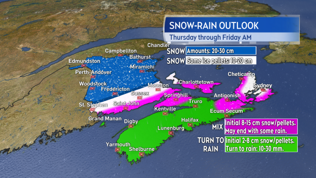
A heavy mix of snow, ice pellets, and rain as the storm moves through. Highest snowfall totals most likely for areas of New Brunswick.
The morning commute on Thursday is still forecast to be largely unaffected by the inclement weather, with conditions deteriorating for the afternoon, evening, and night. The heaviest of the precipitation will clear out Thursday night, though there will be lingering areas of snow and flurries for Friday.
Easterly winds will build through the day on Thursday, peaking late afternoon and evening. Widespread gusts of 40 to 70 km/h are expected for New Brunswick, creating blowing and drifting snow. Gusts of 50 to 80 km/h can be expected for P.E.I. and Nova Scotia, except to near 100 km/h for coastal areas of Digby/Yarmouth/Shelburne, and to near 140 km/h for northern Inverness County, Cape Breton, due to the topography of the Highlands.
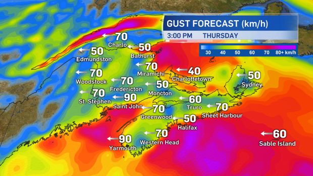
Easterly winds will increase to become strong for Thursday afternoon, evening, and night. The wind turns west and southwest for Friday but will continue gusty for many areas.
The storm is still developing so you should continue to monitor your local forecast for updates. CTV Atlantic will have updates throughout the day at CTVNewsAtlantic.ca and at 5, 6 and 11:30 p.m.
Takeaways:
- The Thursday morning commute still looks OK.
- Weather conditions will deteriorate Thursday afternoon and evening, with developing snow, ice pellets, and rain.
- Easterly winds will increase through Thursday to hit peak gusts in the evening and night.
- Lingering areas of snow and flurries along with still-strong and gusty winds forecast for Friday.


