Frigid temperatures expected to hit the Maritimes later this week
 Cold temperatures cause mist to comes off the L'Assomption River in Saint-Come, Que., on Friday, Jan. 27, 2023. THE CANADIAN PRESS/Sean Kilpatrick
Frigid temperatures are expected to hit the Maritimes later this week as a wave of Arctic air moves into the region.
The outbreak of frigid, Arctic air has triggered extreme cold warnings in the Prairies as well as Ontario, Quebec, and Labrador.
The warnings for those areas of the country call for a wind chill making it feel near or colder than -40 this week.
The public is being advised to watch for cold-related symptoms and that there is an increased risk of frostbite.
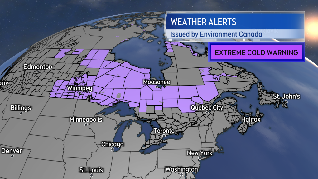 A swath of extreme cold warnings have been issued from the Prairies to Labrador.
The wave of Arctic air we’ll need to watch in the Maritimes moves into northern Ontario and northern Quebec Thursday. That Arctic air is then forecast to enter the Maritimes Friday night into Saturday.
That happens as a strong low pressure system positioned near the coast of Labrador will put the region into a gusty northerly wind. The wind is expected to provide a highway of sorts for that colder air to come rushing down and across our region.
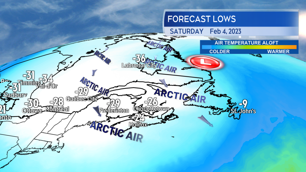 A strong low pressure system near coastal Labrador will force Arctic-sourced air into the Maritimes Friday night into Saturday.
Will it be enough to see extreme cold warnings issued in Atlantic Canada? Possibly.
Ian Hubbard, meteorologist with Environment and Climate Change Canada, said their Atlantic Canada office is anticipating wind chill values may approach the warning criteria of feeling near -35 for parts of the Maritimes Friday night into Saturday.
The last time an extreme cold warning was issued in New Brunswick was Jan. 31 and Feb. 1,, 2022. For Prince Edward Island and Nova Scotia, it was Feb. 23 and 24, 2015.
The cold may be enough to challenge some standing low temperature records for a Feb. 4 as well. The forecast for low temperatures Friday night into Saturday morning looks like it could come within a few degrees of those records at a number of sites in the Maritimes.
There have been some notably cold Feb. 4 days in the past though. Most notably, 1948 and 1971 seem to have set more than a few of the standing record lows.
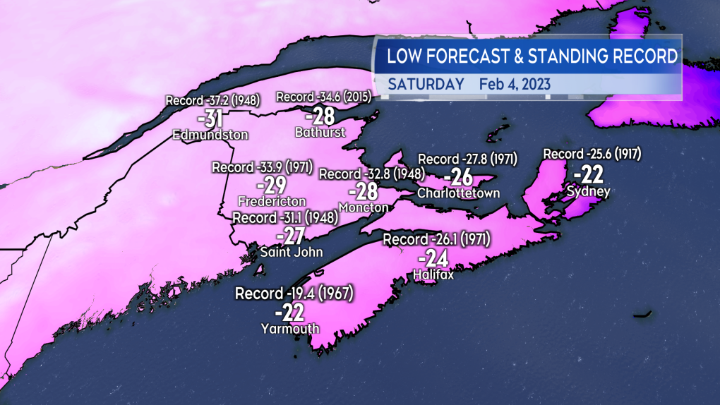 It will be cold enough Saturday morning to watch for possibly matching for breaking records for a Feb. 4.
Frigid conditions are expected through the weekend for the Maritimes. Temperatures may moderate early next week with the return of a southerly wind bringing up some milder air from the U.S. eastern seaboard.
CTVNews.ca Top Stories
B.C. tenants evicted for landlord's use after refusing large rent increase to take over neighbouring suite
Ashley Dickey and her mother rented part of the same Coquitlam duplex in three different decades under three different landlords.
Mountain guide dies after falling into a crevasse in Banff National Park
A man who fell into a crevasse while leading a backcountry ski group deep in the Canadian Rockies has died.
Expert warns of food consumption habits amid rising prices
A new survey by Dalhousie University's Agri-Food Analytics Lab asked Canadians about their food consumption habits amid rising prices.
MPP Sarah Jama asked to leave Ontario legislature for wearing keffiyeh
MPP Sarah Jama was asked to leave the Legislative Assembly of Ontario by House Speaker Ted Arnott on Thursday for wearing a keffiyeh, a garment which has been banned at Queen’s Park.
Charlie Woods, son of Tiger, shoots 81 in U.S. Open qualifier
Charlie Woods failed to advance in a U.S. Open local qualifying event Thursday, shooting a 9-over 81 at Legacy Golf & Tennis Club.
Ex-tabloid publisher testifies he scooped up possibly damaging tales to shield his old friend Trump
As Donald Trump was running for president in 2016, his old friend at the National Enquirer was scooping up potentially damaging stories about the candidate and paying out tens of thousands of dollars to keep them from the public eye.
Here's why provinces aren't following Saskatchewan's lead on the carbon tax home heating fight
After Prime Minister Justin Trudeau said the federal government would still send Canada Carbon Rebate cheques to Saskatchewan residents, despite Saskatchewan Premier Scott Moe's decision to stop collecting the carbon tax on natural gas or home heating, questions were raised about whether other provinces would follow suit. CTV News reached out across the country and here's what we found out.
Montreal actress calls Weinstein ruling 'discouraging' but not surprising
A Montreal actress, who has previously detailed incidents she had with disgraced Hollywood producer Harvey Weinstein, says a New York Court of Appeals decision overturning his 2020 rape conviction is 'discouraging' but not surprising.
Caleb Williams, Jayden Daniels and Drake Maye make it four NFL drafts with quarterbacks going 1-3
Caleb Williams is heading to the Windy City, aiming to become the franchise quarterback Chicago has sought for decades.


