High chance of thunderstorms with showers for parts of the Maritimes Wednesday
Daytime showers
Both Tuesday and Wednesday will feature seasonal warmth and humidity around the Maritimes. A weak trough of low pressure hangs back over the area from the north and is giving enough lift that some spotty showers are likely to develop. For Tuesday, the chance of a shower is highest in the interior of mainland Nova Scotia and southern areas of New Brunswick. Since the shower development is driven by daytime heating as we move through the evening, they will gradually dissipate and end.
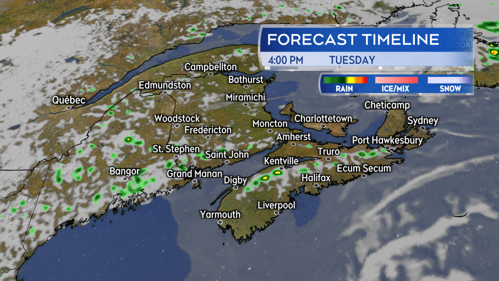 There is mix of sun and cloud on Tuesday in the Maritimes. Isolated showers will develop in the afternoon for parts of southern New Brunswick and the interior of mainland Nova Scotia.
Wednesday thunderstorm potential
Conditions are more favourable for some thunderstorms to develop with pop-up showers for parts of the Maritimes Wednesday.
Western Nova Scotia and New Brunswick will see some isolated showers develop mid-afternoon into early evening. For these areas, there is a low chance some of the showers may develop into small, individual thunderstorms. There is a higher chance of spotty thunderstorms in the northwest of New Brunswick Wednesday.
The most common hazard with any thunderstorms Wednesday will be lightning and brief, localized downpours. The period of highest risk for a thunderstorm will run from about 2 p.m. to 8 p.m. After 8 p.m., they should be in the process of weakening and dissipating.
Wednesday afternoon will also see some scattered showers arrive off the Atlantic for eastern areas of Nova Scotia, including Cape Breton. There is little risk of a thunderstorm with those showers.
 There will be a high chance of isolated thunderstorms in northwestern New Brunswick Wednesday. There will also be a lower chance in other areas of New Brunswick and parts of western Nova Scotia and Prince Edward Island.
Late week rain
This run of generally warm and slightly muggy June weather extends into Friday which is when some change is expected to start arriving for the region.
A weather front, associated with a low-pressure system in northern Quebec, moves towards New Brunswick. Rain and showers are expected to develop for that province through the day. The wet weather will reach P.E.I. and Nova Scotia Friday evening and night.
Showers are expected to clear New Brunswick Friday night and early Saturday morning. The wet weather will be lingering into Saturday for both Nova Scotia and P.E.I.
It is early in the forecast to get a good read on potential rain amounts. It does look like it will be highly varied across the Maritimes with some areas seeing as little as two to 10 mm, but others will see as much as 10 to 40 mm. I expect a more consistent read on the rain amounts by Thursday.
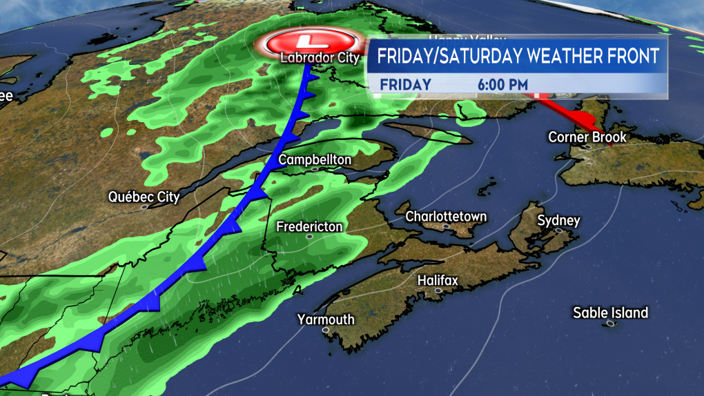 A weather front from the west brings rain and showers to New Brunswick Friday. Wet weather will reach Nova Scotia and P.E.I. Friday evening into Saturday.


CTVNews.ca Top Stories

Police release video of Toronto plaza shooting that killed university student
A university student from Brampton was killed when two shooters fired indiscriminately into a crowded plaza in Toronto last month in what police say was a 'cowardly act.'
'Hopeless and helpless': Regina mother seeks help to treat rare spinal disease
Mary Grace Rico is seeking help in getting treatment for a rare spinal condition.
The iPhone is getting a 'glow' up. What to expect from Apple's Monday event
Apple excited fans with its vision for its 'Apple Intelligence' artificial intelligence system earlier this year. Now, it's time for the company to prove it really works.
No more porta-potties at B.C. construction sites starting Oct. 1
What some B.C. construction workers describe as the worst aspect of their jobs will be coming to an end next month, the province announced.
Trump campaigns in Wisconsin just days ahead of debate with Harris
With just days to go before his first — and likely only — debate against U.S. Vice-President Kamala Harris, former U.S. president Donald Trump leaned into his familiar grievances about everything from his indictments to the border as he campaigned in one of the most deeply Republican swaths of battleground Wisconsin.
'Extremely vigorous' wildfire activity in central B.C. prompts crews to back off for safety
The wildfire fight in central B.C. intensified Friday, according to officials.
They were due to leave for their dream cruise in May. Three months on they’re still stuck at the departure port
It was the years-long cruise that was supposed to set sail, but saw its departure postponed… postponed… and postponed again.
Aryna Sabalenka beats Jessica Pegula to win the U.S. Open for her third Grand Slam title
Aryna Sabalenka got past Jessica Pegula 7-5, 7-5 in a rollicking U.S. Open women’s final Saturday to win her first championship at Flushing Meadows and third Grand Slam title of her career.
Shopping Trends
The Shopping Trends team is independent of the journalists at CTV News. We may earn a commission when you use our links to shop. Read about us.


Toronto
-
Police release video of Toronto plaza shooting that killed university student
A university student from Brampton was killed when two shooters fired indiscriminately into a crowded plaza in Toronto last month in what police say was a 'cowardly act.'
-
Fentanyl-laced gummies discovered in Hamilton: police
Hamilton Police are warning locals of the discovery of fentanyl-laced gummies 'disguised as candy,' after finding them during a recent warrant.
-
Driver ran red light before Whitby hit-and-run that left woman with critical injuries: police
A woman is in hospital in life-threatening condition after she was struck in a hit-and-run in Whitby early Saturday morning.
Calgary
-

Calgary water consumption increases slightly Friday as high temperatures drive up demand
Calgary water consumption ticked up to 505 million litres Friday as sweltering mid-summer temperatures drove up demand.
-
Memorial held for Johnny and Matthew Gaudreau at their New Jersey high school
An emotional memorial was held Friday for Johnny and Matthew Gaudreau at their old high school in Gloucester City, New Jersey.
-
Over 17,000 cases of Chocolate Mint Girl Guide cookies arrive in Calgary as fundraising campaign kicks off
A precious -- and tasty -- cargo arrived in Calgary Saturday.
Edmonton
-

1 dead, 1 injured after semi and SUV crash head-on near Sedgewick
A woman is dead and a man is in hospital after an SUV and a semi truck crashed on Highway 13 near Sedgewick on Friday.
-
Oiler Corey Perry gets assist during Friday Night Smackdown at Rogers Place
The Worm made a guest appearance on WWE's Smackdown at Rogers Place Friday night.
-
Jasper re-entry: Hotels get ready to house residents, recovery workers
Jasper’s hotels will play a key role in providing short-term housing for residents and recovery workers, but they first need a deep clean.
Montreal
-

Former NHLer and addict Brandon Reid's new goal is to help others beat addiction
Brandon Reid was a promising NHLer for the Vancouver Canucks, but his struggles with addiction almost killed him. He now trains other addicts as they fight to stay sober.
-
Teen killed on e-scooter near Montreal park honoured, calls for more safety measures
Family and community members gathered in Montreal's Cartierville neighbourhood on Saturday to pay respects to a 14-year-old boy who was killed while riding a scooter in the summer.
-
Petition calls for service dog subsidy for those with autism in Quebec
A petition has garnered more than 10,000 signatures calling for the Quebec subsidy for service dogs to be extended to those with autism.
Ottawa
-

Here's what the latest rate cut means for mortgage holders, home buyers
The Bank of Canada has lowered its key interest rate by 25 basis points to 4.25 per cent.
-
Garage fire displaces two adults in Orleans
Ottawa Fire Services says two adults have been displaced following a fire that started in the garage of their home in Orleans Friday evening.
-
Ottawa canoeist Brianna Hennessy wins Paralympic silver medal
Canadian para canoeist Brianna Hennessy raced to her first Paralympic medal with a reminder of her mother on her paddle.
London
-

‘Proactive enforcement’: City of London housing blitz aims at helping tenants address issues with landlords
The City of London’s municipal enforcement team spent Saturday at 700 units on Kipps Lane, helping tenants address property standards issues.
-
Strathroy-Caradoc police searching for robbery, stabbing suspects
The Strathroy-Caradoc police are investigating a robbery and stabbing following an incident early Saturday morning.
-
Trial against former Woodstock mayor, Trevor Birtch, continues
The trial of former Woodstock mayor, Trevor Birtch, continued on Friday.
Barrie
-

3-car crash in Midland
Three vehicles were involved in a crash on Bayshore Drive near Frank Street in Midland on Saturday.
-
Alleged sexual assault under investigation
Officers from Southern Georgian OPP are investigating an alleged overnight sexual assault incident in Midland last weekend.
-
Parkinson's 'SuperWalk' raises more than $30K
The 35th annual Parkinson Canada 'SuperWalk' in Barrie on Saturday raised more than $30,000 to support Parkinson's Disease research.
Northern Ontario
-

Despite union protest, new hybrid work rules for federal employees kick in Monday
Public service unions will start the week with an early-morning rally opposing the policy. But despite the unions' 'summer of discontent' and an ongoing court challenge, the new rules will still kick in on Sept. 9.
-
Sudbury OPP officer pleads guilty to stealing evidence during moose hunt investigation
A veteran staff sergeant with the Ontario Provincial Police in Sudbury has been sentenced for stealing two items from a First Nations man and hiding what he did while his fellow officers searched for them.
-
Fentanyl-laced gummies discovered in Hamilton: police
Hamilton Police are warning locals of the discovery of fentanyl-laced gummies 'disguised as candy,' after finding them during a recent warrant.
Kitchener
-

Three teens charged for armed robbery at Kitchener jewelry store
Three teens were arrested for an armed robbery at a Kitchener jewelry store after witnesses caught and detained the suspects until officers arrived on scene.
-
'They just see these tenants as a profits': Guelph residents fighting back against renoviction
Guelph tenants worry they'll have find a new home after recently receiving N-13 notices from their new apartment owner.
-
Some operators losing provincial funding after opting out of $10-a-day child care program
Child care centres that decided not to participate in the national $10-a-day program will soon lose some of their provincial funding.
Windsor
-

Two knives said to be involved in Friday’s fatal police-involved shooting: SIU
The Special Investigations Unit’s (SIU) forensic investigators remain on scene Saturday afternoon following Friday’s fatal shooting involving a Windsor police officer.
-
VIDEO
VIDEO Has Walkerville become the 'new downtown' of Windsor? These residents say yes
Citing a vibrant business and dining scene, more active streets and a perception of greater safety, residents at a new event in Walkerville say the neighborhood has become Windsor's "new downtown," outshining the traditional core as the city's most desirable place to be — day or night.
-
Chatham-Kent police remind drivers to watch for deer
Chatham-Kent police are reminding drivers to watch for deer while out on the roads, especially at dusk and dawn.
Winnipeg
-

Premier says Manitoba grand chief to lie in state at provincial legislature
Grand Chief Cathy Merrick of the Assembly of Manitoba Chiefs will lie in state at the provincial legislature following her sudden death.
-
Winnipeg Blue Bombers down Saskatchewan Roughriders 26-21
The Winnipeg Blue Bombers defeated the Saskatchewan Roughriders 26-21 on Saturday, marking the team's fifth-straight victory and fifth Banjo Bowl win in a row.
-
Corn maze craze: Where to get lost this fall
Corn maze season has officially begun throughout Manitoba – a sign that fall is just around the corner.
Regina
-

Winnipeg Blue Bombers down Saskatchewan Roughriders 26-21
The victory moved the Bombers into top spot in the CFL's West Division, while the Roughriders remain in third after failing to win for a seventh straight outing.
-
'Hopeless and helpless': Regina mother seeks help to treat rare spinal disease
Mary Grace Rico is seeking help in getting treatment for a rare spinal condition.
-
These two political parties in Saskatchewan are considering an alliance
Two political parties in Saskatchewan are considering a potential alliance ahead of the upcoming provincial election.
Saskatoon
-
Winnipeg Blue Bombers down Saskatchewan Roughriders 26-21
The victory moved the Bombers into top spot in the CFL's West Division, while the Roughriders remain in third after failing to win for a seventh straight outing.
-
These two political parties in Saskatchewan are considering an alliance
Two political parties in Saskatchewan are considering a potential alliance ahead of the upcoming provincial election.
-
Teen girl charged with attempted murder after student set on fire at Saskatoon high school
A 14-year-old girl faces an attempted murder charge after a 15-year-old girl was doused in a flammable substance and set on fire at a Saskatoon high school Thursday.
Vancouver
-

Major BC Ferries vessel will be out of service for 6 months
One of the vessels that services the busy Tsawwassen-Swartz Bay route will be out of commission for about six months after its propeller fell off, according to BC Ferries.
-
Man carrying handgun and nearly $30K in cash arrested in Victoria, police say
Police in Victoria say they arrested a man they found in possession of a loaded handgun and more than $29,000 worth of cash earlier this week.
-
Fire destroys commercial greenhouse in Surrey
A large fire destroyed a greenhouse in Surrey early Saturday morning, causing "quite a spectacle," according to firefighters.
Vancouver Island
-
Major BC Ferries vessel will be out of service for 6 months
One of the vessels that services the busy Tsawwassen-Swartz Bay route will be out of commission for about six months after its propeller fell off, according to BC Ferries.
-
Man carrying handgun and nearly $30K in cash arrested in Victoria, police say
Police in Victoria say they arrested a man they found in possession of a loaded handgun and more than $29,000 worth of cash earlier this week.
-
'Extremely vigorous' wildfire activity in central B.C. prompts crews to back off for safety
The wildfire fight in central B.C. intensified Friday, according to officials.
Kelowna
-

Charges laid in hit-and-run that killed Kelowna teen
A man has now been charged for his alleged role in a hit-and-run that killed a teenager in Kelowna, B.C., last fall.
-
Have you seen Lulu? Kelowna RCMP searching for stolen puppy
Mounties in Kelowna are appealing to the public for help reuniting a stolen puppy named Lulu with its owner.
-
RCMP issue 'strong warning' against unsanctioned pre-grad parties in B.C.'s Okanagan
Authorities are urging parents in B.C.'s Okanagan to speak with their teenagers about the dangers of attending "unsanctioned" pre-graduation parties.


