Kalin's Call: Building heat and humidity triggers heat warnings for Maritimes

HALIFAX -
It’s expected to be a very warm and very muggy week ahead for the Atlantic region.
Positioned between high pressure to our east and a developing series of weather fronts to the west, the Maritimes will be in a steady southerly flow in the atmosphere into the start of the weekend.
That, in combination with a building ridge in the jet stream, will allow humid sub-tropical air to move up the eastern seaboard.
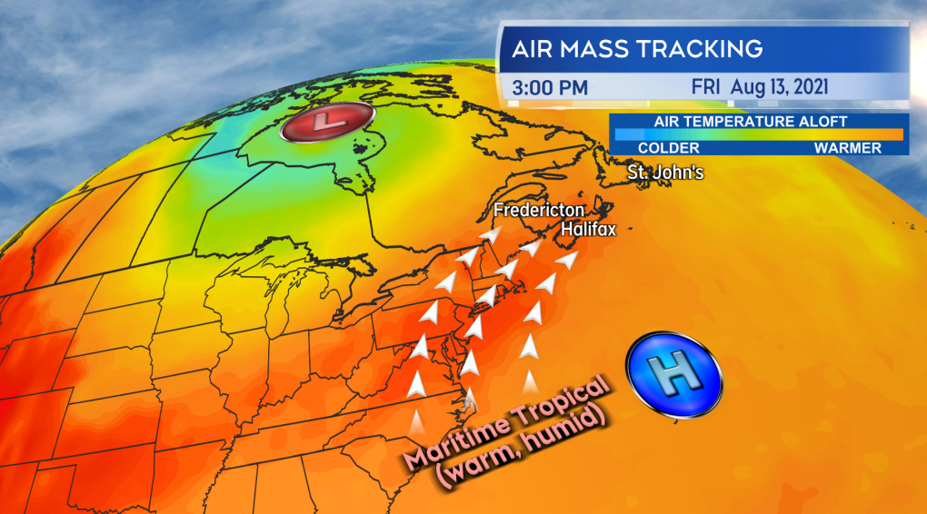 Squeezed between low pressure to the west and high pressure to the east, warm and humid air will move up the eastern seaboard and into the Maritimes this week.Squeezed between low pressure to the west and high pressure to the east, warm and humid air will move up the eastern seaboard and into the Maritimes this week.
Daytime highs are expected to reach up into the high 20’s and even low 30’s for much of the region over the coming days.
The exception will be coastal areas that could see low cloud and fog hold on longer into the day, along with onshore winds off ocean waters.
Those coastal locations can expect highs to mostly range low-to-mid 20’s, though still with a very humid feel to the air. Humidex values are expected to make it feel into the 30’s at times.
During the nights, low temperatures aren’t expected to cool lower than mid-to-high teens and even low 20’s.
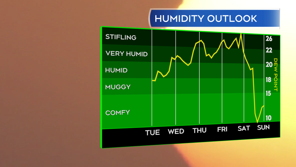 The heat and humidity builds towards a peak Thursday into Saturday. A weather front is expected to break the muggy weather on Sunday.The heat and humidity builds towards a peak Thursday into Saturday. A weather front is expected to break the muggy weather on Sunday.
The combination of conditions has already led to Heat Warnings being issued for parts of the region. Currently they are in effect for Bathurst and across the Acadian Peninsula in New Brunswick as well as the Valley into Cumberland, Colchester and Pictou Counties of Nova Scotia.
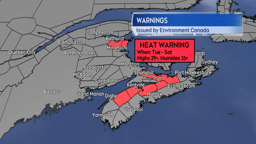 Heat Warnings in effect by Environment Canada as of 1 p.m. Tuesday.Heat Warnings in effect by Environment Canada as of 1 p.m. Tuesday.
The peak of the heat and humidity looks to be Thursday, Friday, and possibly Saturday.
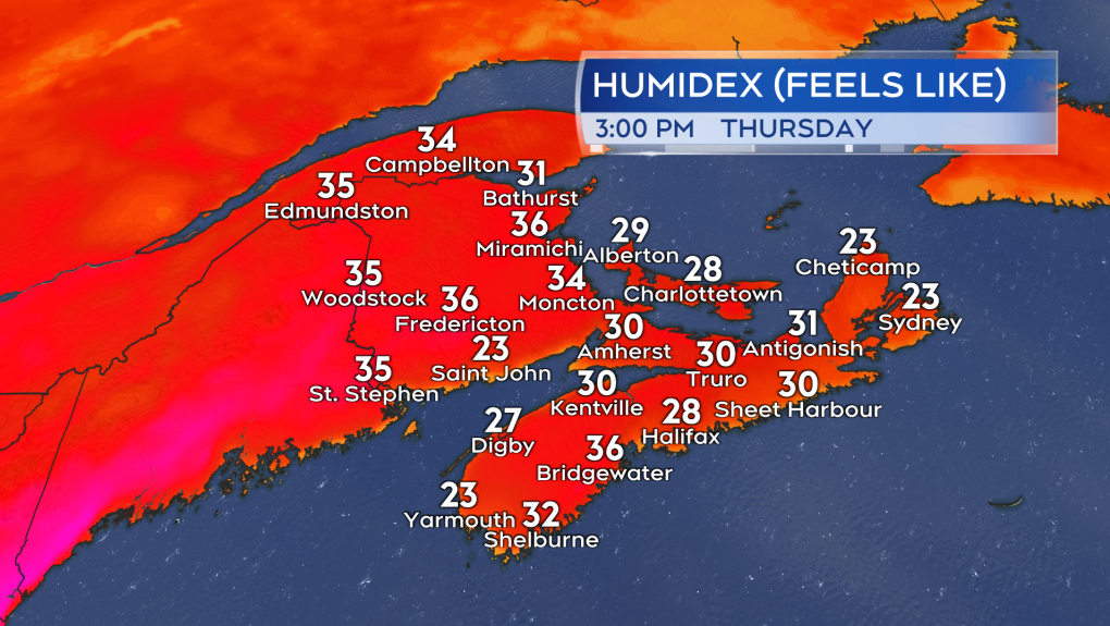 The humidex is expected to make it feel into the 30’s across a large portion of the Maritimes by Thursday. Exceptions for some coastal/near coastal communities.The humidex is expected to make it feel into the 30’s across a large portion of the Maritimes by Thursday. Exceptions for some coastal/near coastal communities.
Late Saturday and Sunday a cold front is expected to pass through with scattered showers. The muggy conditions should break behind that front Sunday into Monday.


CTVNews.ca Top Stories

Federal government to further limit number of international students
The federal government will be further limiting the number of international students permitted to enter Canada next year. It's the government's latest immigration-related measure to address Canadians' ongoing housing and affordability concerns.
Search for suspect in Kentucky highway shooting ends with discovery of body believed to be his
Authorities say they believe the body of a man suspected of shooting and wounding five people on a Kentucky interstate highway has been found.
Here's why you should get all your vaccines as soon as possible
With all these shots, some Canadians may have questions about the benefit of each vaccine, whether they should get every shot and how often to get them, and if it's safe to get them all at once or if they should space them out.
Bloc MPs will vote confidence in Liberal government next week: Blanchet
The Conservatives' first shot at toppling the Liberal government is likely doomed to fail, after Bloc Quebecois Leader Yves-François Blanchet told reporters his MPs will vote confidence in the government.
'I'm here for the Porsche': Video shows brazen car theft in Mississauga
Video of a brazen daylight auto theft which shows a suspect running over a victim in a stolen luxury SUV has been released by police west of Toronto.
Exploding electronic devices kill 20, wound 450 in second day of explosions in Lebanon
Lebanon's health ministry said Wednesday that at least 20 people were killed and 450 others wounded by exploding electronic devices in multiple regions of the country. The explosions came a day after an apparent Israeli attack targeting pagers used by Hezbollah killed at least 12 and wounded nearly 3,000.
'It starts off innocent': Manitoba man loses $185,000 to crypto-romance scam
A Manitoba man is warning others after he fell victim to an elaborate online scam over the summer.
Teen faces new charge in Sask. high school arson attack
A 14-year-old student who allegedly set her classmate on fire is facing a new charge.
Quebec woman charged with first-degree murder in death of five-year-old boy
A 29-year-old Quebec woman is facing a first-degree murder charge in the death of a five-year-old boy southwest of Montreal.
Shopping Trends
The Shopping Trends team is independent of the journalists at CTV News. We may earn a commission when you use our links to shop. Read about us.


Toronto
-

'I'm here for the Porsche': Video shows brazen car theft in Mississauga
Video of a brazen daylight auto theft which shows a suspect running over a victim in a stolen luxury SUV has been released by police west of Toronto.
-
Two people dead after shooting at park north of Toronto: YRP
Two people are dead following an early-morning shooting at a park in a quiet neighbourhood in Keswick, York Regional Police say. Police confirmed just before 11 a.m. that they were investigating a double homicide at Bayview Park. YRP said they responded to the sounds of gunshots at the park just before 7:30 a.m.
-
Here are the restaurants in the 2024 Michelin Guide Toronto & Region
The Michelin Guide has released its 2024 restaurant selection for the Toronto region, with four new establishments getting a Michelin star.
Calgary
-

Calgary mayor, council left in 'very compromised position' by Green Line calamity
Calgary's Mayor Jyoti Gondek says city council is in "a very compromised position" after the derailing of the Green Line LRT.
-
Alberta's $8.6B school plan prompts concerns over funding of private builds
The provincial government's multibillion-dollar plan to fast-track the building of new schools is raising concerns over the funding of private school construction.
-
Man charged in relation to Sunday sexual assault of 12-year-old girl in southeast Calgary
A Calgary man has been charged with sexual assault and sexual interference in relation to an incident with a 12-year-old child that took place in the southeast Calgary community of Walden.
Edmonton
-

52-year-old man charged with sexually assaulting teen boy
A 52-year-old man is facing sexual assault charges in connection with the assault of a teen boy.
-
"Disheartening and disconcerting': Smith criticized for 'shared values' comments in provincial address
Premier Danielle Smith is drawing criticism over comments made during her provincial address.
-
Fire that affected more than 100 people in southwest Edmonton 'suspicious': police
Police say a fire in a southwest Edmonton neighbourhood early this morning is "suspicious."
Montreal
-

Quebec woman charged with first-degree murder in death of five-year-old boy
A 29-year-old Quebec woman is facing a first-degree murder charge in the death of a five-year-old boy southwest of Montreal.
-
Laval health authority seeks 40 Foster Families as dozens of children await care
The Laval health authority, CISSS de Laval, says dozens of children need foster care, but there aren't enough families to take them in. The agency is now asking people to open their homes and provide these children with the stability they need.
-
Montreal Children’s Hospital will double cancer trials after $1 million donation
Thanks to a generous donation, the Montreal Children’s Hospital will now be able to double the number of cancer trials it offers to young patients.
Ottawa
-

Woman missing, man rescued on Ottawa River after going out in a kayak
A search is underway in the Ottawa River for a 30-year-old woman reported missing while kayaking near Pembroke, Ont.
-
Maplewood Secondary School students could be in classes next week if school passes next inspection
Parents and guardians of students who were supposed to be attending a new high school in Stittsville gathered at a nearby elementary school for a public meeting on the ongoing delays keeping Maplewood Secondary School closed.
-
Forensic identification officer testifies at Ayoub trial
Photographs of eyeglasses with an apparent broken arm, a purse with a "severed" strap and a reusable bag filled with groceries at the bottom of a staircase were among those shown to the jury at the first-degree murder trial of Hamid Ayoub Wednesday morning.
London
-

Sentencing hearing in field party shooting
The mother and brother of an 18-year-old who was shot and killed during a teen field party more than three years ago gave emotional victim impact statements on Wednesday.
-
One dead following Lambton County crash
Around 1:00 p.m. on Tuesday, September 10, OPP, EMS, and local fire services were called to the scene of a two-vehicle collision on Egremont Road in Warwick Township.
-
$10-million lawsuit filed against Fanshawe College
Fanshawe College is being sued over supposed deficiencies in its paralegal program. A proposed class action seeks $10 million in damages on behalf of hundreds of students enrolled in the college's paralegal program since 2020.
Barrie
-

Brides and vendors claim they were ripped off by Barrie photographer
A growing group of brides and wedding photographers from across the province say they have been taken for tens of thousands of dollars by a Barrie, Ont. wedding photographer.
-
Grey County ticket wins half the record-breaking Lotto Max jackpot
Check your lottery tickets because someone who purchased a ticket in Grey County is an overnight multi-millionaire, having won half of the historic lottery jackpot.
-
Two people dead after shooting in Keswick park
York Regional Police say two people are dead after a shooting at a park in the community of Keswick.
Northern Ontario
-

Pilot project will see Sudbury police wearing body cameras next year
Some Greater Sudbury Police officers will wear body-worn cameras as part of a pilot project beginning in 2025.
-
One person dead following North Bay industrial incident
North Bay Police Service says one person has died following an industrial accident at the Ontario Northland Transportation Commission Rail Yard on Tuesday.
-
Detour available after serious collision on Hwy. 101
A detour is now available after Highway 101 closed in both directions between Foleyet and Highway 144, police said Wednesday.
Kitchener
-

Three missing people from Kitchener haven't been seen since Sept. 1
Police are hoping the public can help them locate three missing people from Kitchener.
-
40 people displaced due to fire at Brantford’s largest homeless shelter
A fire broke out Tuesday night at Rosewood House, Brantford’s largest homelessness shelter, leaving 40 residents without a place to stay or the essential services they rely on.
-
Blair residents fear new Amazon facility will bring more noise and traffic
Residents in Blair say they’re concerned with the potential noise and traffic that will come with the newest Amazon fulfilment centre set to open this month.
Windsor
-

Residents and business owners frustrated by ongoing Tecumseh Road East construction
People who live and work along Tecumseh Road East say they are frustrated by months-long construction that has blocked portions of the sidewalk and kept customers away from businesses.
-
Police seek suspects after $64,000 bank fraud
Windsor police are asking for the public’s help to identify two suspects involved in a $64,000 bank fraud investigation.
-
Windsor-made documentary premieres on Bell Fibe TV
A new home-grown automotive reality television series has premiered on Bell Fibe TV.
Winnipeg
-

Tornado warning ended, thunderstorm warnings continue
Parts of the province are under a severe thunderstorm warning, while much of the south is under a watch.
-
'It starts off innocent': Manitoba man loses $185,000 to crypto-romance scam
A Manitoba man is warning others after he fell victim to an elaborate online scam over the summer.
-
'Substantial seizure': $300K worth of stolen vehicles recovered from Winnipeg compound
More than $300,000 worth of stolen vehicles were seized from a Winnipeg compound earlier this month, police announced Wednesday.
Regina
-

Executive committee passes purchase of new homeless shelter, council approval required
Regina Executive Committee has passed the purchase of a new building for a low-barrier homeless shelter in Regina.
-
Tornado warning in place for parts of southeast Sask.: Environment Canada
A tornado warning is in place for parts of southeast Saskatchewan on Wednesday evening.
-
Yorkton RCMP seize cocaine in drug trafficking investigation
An ongoing investigation into drug trafficking has resulted in the seizure of cocaine in Yorkton, according to RCMP.
Saskatoon
-

Thomas Hamp believed a 'secret police' were after him the night he killed his girlfriend
Thomas Hamp says he believed secret police were out to kidnap, torture, and kill him when he fatally stabbed his girlfriend Emily Sanche in February of 2022.
-
Teen faces new charge in Sask. high school arson attack
A 14-year-old student who allegedly set her classmate on fire is facing a new charge.
-
'I thought I was dead': Man electrocuted, burned at SaskPower hydro dam calls for compensation
May 9, 2022 was the day Blayne McKay thought he was going to die. He called his wife to say goodbye, after getting electrocuted at the SaskPower Island Falls Hydroelectric Station, about 100 kilometres northwest of Flin Flon.
Vancouver
-

Former federal cabinet minister not ruling out court action to get a new B.C. Liberal Party
Former federal Liberal cabinet minister Herb Dhaliwal wants to help fill the political gap left by the collapse of BC United.
-
Credit cards, passports, licences: Metro Vancouver police find thousands of pieces of stolen mail
New Westminster police believe they uncovered evidence of an identity fraud operation when they found some 8,000 pieces of stolen mail in a home in the city’s Uptown neighbourhood.
-
Provincial parties discuss public safety as Vancouver BIA presses for platform details
Just over one month before British Columbians head to the polls, public safety – and perceptions of public safety – appear to be issues that will dominate on the campaign trail.
Vancouver Island
-
Former federal cabinet minister not ruling out court action to get a new B.C. Liberal Party
Former federal Liberal cabinet minister Herb Dhaliwal wants to help fill the political gap left by the collapse of BC United.
-
B.C. police watchdog clears Mounties of wrongdoing after man's arm broken during traffic stop
British Columbia's police oversight agency says there are no grounds for criminal charges against four Mounties after a man's arm was broken during an arrest on Vancouver Island.
-
'Trove of extraordinary fossils' discovered in northern B.C., museum says
Paleontologists from the Royal B.C. Museum have uncovered "a trove of extraordinary fossils" high in the mountains of northern B.C., the museum announced Thursday.
Kelowna
-

Pregnant pit bull with 10 puppies rescued from rat-infested B.C. home
Animal protection officers in British Columbia have rescued three pit bulls – including one that gave birth to 10 puppies – from a rat-infested home in Kelowna.
-
Son charged with B.C. woman's murder: RCMP
More than a year after a missing Kamloops, B.C., woman’s body was found, her son has been arrested and charged with her murder, Mounties announced Friday.
-
Woman stabbed during daylight Kelowna home invasion: RCMP
A woman suffered life-threatening injuries after being stabbed during a home invasion in Kelowna, according to authorities.


