Kalin's Call: Post-tropical Nicole brings rainy and windy Saturday
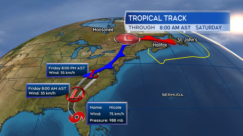
Nicole made landfall in Florida at 4 a.m. Atlantic Time Thursday as a category 1 hurricane in the vicinity of Vero Beach, Florida.
Since then, Nicole has weakened to a tropical storm as it moved to position northeast of Tampa. The continued weakening of the system is expected as it remains over land. Tropical storm force winds are still expected to impact portions of Florida, Georgia, and South Carolina into Thursday night. Heavy rain totaling 50 to 100 mm may fall in the central Appalachians and eastern areas of Tennessee, Kentucky, and Ohio. New England could also see totals of 25 to 100 mm out of the rain.
The remnants of Nicole will combine with a weather front to produce a rainy and windy Saturday for the Maritimes.
 The remnants of Nicole will combine with a cold front to produce a rainy and windy Saturday for the Maritimes.
WIND
The highest wind on Saturday will be mostly out of the south for the Maritimes, with the exception of northern New Brunswick which will be a more easterly wind. Widespread gusts of 40 to 60 km/h should be expected through the day. Peak gusts could reach 60 to 80 km/h on the Bay of Fundy and eastern coastline of New Brunswick, Atlantic coastline of Nova Scotia, Cape Breton, and Prince Edward Island. Due to the topography of the highlands, northern Inverness County Cape Breton will likely hit some gusts near or in excess of 100 km/h. The wind falls into a range that would be expected out of an autumn storm.
Some extra caution may be warranted as there could be some trees/branches and infrastructure more vulnerable due to previous damage from Fiona. Any easily wind-blown objects/furniture should be secured. I wouldn’t expect widespread power outages from a system such as this, but there will probably be some scattered across the region. Watch for impacts to ferry services and possible traffic restrictions on bridges/causeways.
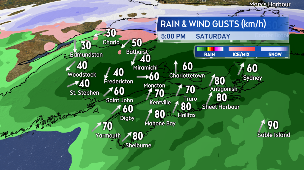 Widespread gusts of 40 to 60 km/h expected Saturday with some areas hitting peak gusts of 60 to 80 km/h
RAIN
It’s a good slug of fall rain for the region. A widespread 20 to 40 mm with some totals that could climb into a range of 40 to 70 mm. The higher rainfall amounts look most likely in New Brunswick and western P.E.I. Can’t rule out some higher totals in Digby, Yarmouth and Inverness counties of Nova Scotia as well. Given that the rain will have a tropical component, be aware that higher rainfall rates and downpours are possible. It would be a good idea to check that drainage is free and clear of any fall debris to help with water runoff.
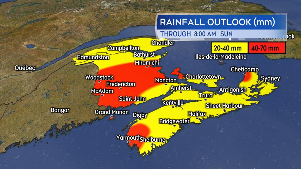 A general 20 to 40 mm of rain though with a risk that some areas could see higher totals of 40 to 70 mm.
COASTS
There will be minimal risk of coastal flooding or storm surge with this system. Be careful on the coasts around high tides on the Bay of Fundy and Acadian coastlines of New Brunswick and the Atlantic coastline of Nova Scotia on Saturday due to increased wave action and onshore wind. Any vessels operating in marine areas should check a detailed marine forecast as a strong wind and increased wave heights will be present.
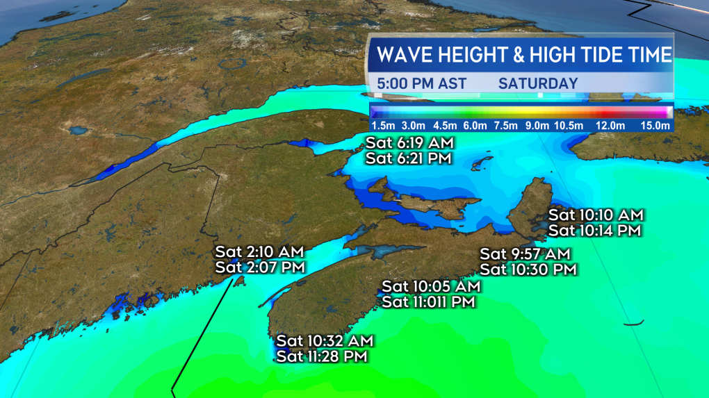 Storm surge isn’t expected to be a hazard with the storm. There will increased wave action and strong-to-storm force marine winds.
WEATHER ALERTS
As of Thursday, a tropical cyclone information statement, outlining a combination of the weather front and post-tropical Nicole, remains in effect by the Canadian Hurricane Centre for the Maritimes. An additional special weather statement is in place for both New Brunswick and Prince Edward Island. That statement not only advises that some higher winds gusts may be present but that those areas are under higher risk of seeing heavier rain. I’ll have an update on our CTV Atlantic News programming at 5, 6, and 11:30 p.m.


CTVNews.ca Top Stories

DEVELOPING
DEVELOPING Canada issues travel warning as Hurricane Beryl tears through southeast Caribbean
As Hurricane Beryl rips toward the southeast Caribbean, Global Affairs Canada is warning travellers to avoid non-essential travel to Jamaica as well as several countries in the region.
Canadian feels 'abandoned' in Mexico after WestJet strike
More than 1,100 WestJet flights and counting have been cancelled since last Thursday, when a strike by the airlines mechanics union grounded travel plans for more than 100,000 customers.
Trudeau won't commit to national caucus meeting, says he's having calls with MPs
Prime Minister Justin Trudeau said he's been taking calls from different members of his Liberal caucus following the party's historic byelection loss in a downtown Toronto riding last week, but his focus remains on governing.
Nearly four out of 10 Ontarians considering leaving due to cost of housing: survey
Nearly four out of 10 Ontarians say that they are considering leaving the province due to the high cost of housing, a new survey has found.
1 dead, 2 injured after helicopter crash near B.C.-Alberta border
One person was killed and two others were injured in a helicopter crash near the B.C.-Alberta border on Tuesday evening, according to the RCMP.
Hurricane Beryl roars toward Jamaica after killing at least 6 people in the southeast Caribbean
Hurricane Beryl was roaring toward Jamaica on Wednesday, with islanders scrambling to make preparations after the powerful Category 4 storm earlier killed at least six people and caused significant damage in the southeast Caribbean.
Popular weight loss and diabetes drugs linked to increased risk of rare form of blindness
People who take Ozempic or Wegovy may have a higher risk of developing a rare form of blindness, a new study suggests. Still, doctors say it shouldn’t deter patients from using the medicines to treat diabetes or obesity.
Delta flight diverts to New York after passengers are served spoiled food
A Delta flight from Detroit to Amsterdam was diverted to New York's Kennedy Airport on Wednesday after passengers were served spoiled food, airline officials said.
The son of Asia's richest man is getting married in one of India's most anticipated — and lavish — weddings of the year
Billionaire heir Anant Ambani is set to marry his longtime girlfriend Radhika Merchant later this month, in a lavish ceremony widely described as the country's wedding of the year.
Shopping Trends
The Shopping Trends team is independent of the journalists at CTV News. We may earn a commission when you use our links to shop. Read about us.


Toronto
-

All tents at UofT encampment appear to have been taken down ahead of 6 p.m. deadline
All tents at a pro-Palestinian encampment at the University of Toronto appear to have been taken down ahead of a 6 p.m. deadline to clear the site.
-
Pedestrian dead after being struck by streetcar in Parkdale: paramedics
A pedestrian has died after being struck by a streetcar in Parkdale, Toronto paramedics say.
-
Man wanted after several people randomly assaulted in Leslieville on Canada Day
A man is wanted after several people were assaulted without provocation within 10 minutes in Toronto’s east end on Monday.
Calgary
-

Calgary remains in 'recovery mode'; outdoor water restrictions still in place
Calgary Mayor Jyoti Gondek says while indoor water use has returned to normal, city officials aren't yet ready to lift outdoor restrictions.
-
'Pretty exciting': Calgary's 'Blue Sky City' logo revealed
Calgary's new logo for its 'Blue Sky City' civic brand has officially been revealed as creators of the design hope it sends a welcoming message and acts as a nod to innovation.
-
2 people sent to hospital following crash near Lac Des Arcs
A youth and an adult, both from Canmore, Alta., are in hospital following a crash on the Trans-Canada Highway on Wednesday.
Edmonton
-

CTV News Edmonton's top 5 stories for June 2024
From the Edmonton Oilers' Stanley Cup Final run to another battle between Premier Danielle Smith and Prime Minister Justin Trudeau, these were the top five stories on CTVNewsEdmonton.ca in June.
-
With rise in bear spray assaults, Edmonton changes bylaw to regulate sales
The City of Edmonton has amended its bylaw to regulate sales of bear spray.
-
Edmonton's amendment of its 15-minute city plan 'legitimizes the conspiracy theory': professor
The topic of 15-minute cities returned to Edmonton city hall last week. Discussions about the urban-planning design led city councillors to make an amendment to its plan to appease concerns about movement. Canadian Research Chair and Health Law and Policy Chair at the U of A Prof. Tim Caulfield joined CTV Morning Live to discuss the conspiracy theories surrounding 15-minute cities.
Montreal
-

Irish prime minister 'appalled' by Montrealer's death after alleged assault
Ireland's prime minister says he's "absolutely appalled" by an assault in the country's capital that resulted in the death of a tourist from Montreal.
-
Quebec realtors buying homes, selling at higher prices to make a quick profit
The number of disciplinary cases against Quebec realtors accused of "financially abusing" their clients is going up.
-
DEVELOPING
DEVELOPING Canada issues travel warning as Hurricane Beryl tears through southeast Caribbean
As Hurricane Beryl rips toward the southeast Caribbean, Global Affairs Canada is warning travellers to avoid non-essential travel to Jamaica as well as several countries in the region.
Ottawa
-

Tewin development project passes latest hurdle, but some say it still doesn't belong
A future suburb in the city's southeast end is raising concerns amongst some councillors and residents over the price tag to service the area.
-
Mel C, aka Sporty Spice, coming to Ottawa in September
Former Spice Girl turned DJ Melanie C, also known as Sporty Spice, will be making her Ottawa debut this fall.
-
Report shows rise in violent crimes in Ottawa
Violent crimes in Ottawa have increased by three per cent in 2023, according to Ottawa Police Service's annual report.
London
-

Youth charged with murder in death near Clinton Ont.
Police in Huron County are overseeing a death investigation. Around 4:15 p.m. on Tuesday, emergency services responded to an address on Cut Line Road between Parr Line and Tipperary Line in Central Huron.
-
St. Thomas police investigating suspicious death as a homicide
Police in St. Thomas are investigating a death. Police and fire officials are on scene in the area of Hiawatha and Curtis Street.
-
Charges laid in last weekend's south end robbery
A south end robbery that took place this past weekend has seen charges laid against a man and a woman. Late Sunday night, the pair entered a business in the 300 block of Southdale Road East.
Barrie
-
Road closed after serious single vehicle crash in Tiny Township
Emergency crews are responding to a motor vehicle collision on Crossland Road and Townline in Tiny Township.
-
Criminal charges against 20-year Barrie police officer dropped
Barrie Police Sgt. Bruce Gardiner has been exonerated.
-
Emergency crews rescue distressed senior along local trail
On Wednesday, a distressed senior was successfully rescued along a trail in New Tecumseth, Ont.
Northern Ontario
-

Tentative sale agreement could save northern Ont. cheesemaker
The owner of Thornloe Cheese announced Wednesday it has a tentative agreement in place to sell the northern Ontario cheesemaker to Mississauga-based Triple ‘A’ Cheese.
-
Ontario man suffers cardiac arrest in Florida. This is why insurance won't cover his $620,000 hospital bill
An Ontario man who wanted to spend time with his family in Florida was hospitalized after suffering a cardiac arrest at the airport as he was about to fly back to Canada.
-
Sault man charged with assault after allegedly throwing hypodermic needle
A man has been charged with assault with a weapon following a confrontation between neighbours on Tuesday in the Sault.
Kitchener
-
Youth charged with murder in death near Clinton Ont.
Police in Huron County are overseeing a death investigation. Around 4:15 p.m. on Tuesday, emergency services responded to an address on Cut Line Road between Parr Line and Tipperary Line in Central Huron.
-
Public assistance requested to identify suspicious person
The Stratford Police Service (SPS) is looking for the public’s help identifying a suspicious person.
-
St. Thomas police investigating suspicious death as a homicide
Police in St. Thomas are investigating a death. Police and fire officials are on scene in the area of Hiawatha and Curtis Street.
Windsor
-

Maidstone couple unearths 'rare find' in backyard
A Maidstone couple discovers an unexpected object while doing landscaping in their backyard.
-
Rescheduling Halloween? Kingsville calls for community input
A trick or a treat? The Town of Kingsville wants residents to weigh in on rescheduling Halloween.
-
Chatham-Kent wraps up Talbot Trail Environmental Assessment Addendum Study
The Municipality of Chatham-Kent has finished a Municipal Class Environmental Assessment Addendum Study to create a temporary bypass route for Talbot Trail between Coatsworth Road and Stevenson Road.
Winnipeg
-

Police searching for 'high risk' sex offender for breaching conditions
Police are looking for a sex offender wanted for breaching conditions imposed on him when he was released from prison in June.
-
Manitoba First Nation uncovers 187 anomalies at former residential school
A search of the grounds of a former residential school in northern Manitoba has uncovered 187 anomalies, according to First Nation leaders.
-
Winnipeg snow clearing has gone over budget for last decade: report
The City of Winnipeg has exceeded its snow clearing budget every year for the past decade.
Regina
-

Sask. woman makes NHL history behind the bench
Roccanville's Jessica Campbell has been hired by the Seattle Kraken, making her the first woman to be hired as a full-time coach in the National Hockey League (NHL).
-
Sask. couple discovers skunk litter in their yard
A couple near Pense, Sask. recently came home from vacation to quite the surprise: a litter of skunks in their yard.
-
Father/son duo from Saskatoon want to represent Indigenous community on Amazing Race Canada
A father and son team from Saskatoon are hoping to win the top prize on the Amazing Race Canada, while also representing their Indigenous community on a national stage.
Saskatoon
-

Sask. city councillor files affidavit denying abuse at private Christian school
A Saskatoon city councillor is denying his involvement in alleged abuse at a private Christian school.
-
Sask. man who escaped police found dead, death deemed non-suspicious
A Sask. man who escaped RCMP custody in Dinsmore, Sask. has been found dead.
-
Prince Albert homicide victim identified as Norman Wenzel, 'always funny' father of four
Prince Albert’s latest homicide victim has been identified as 41-year-old Norman Wenzel.
Vancouver
-

Alleged 'inappropriate' dispensing of narcotics under investigation at Vancouver pharmacy
A pharmacy in South Vancouver has been temporarily closed as a B.C. regulator investigates allegations of "improper" administration of safe supply drugs.
-
B.C. nurse reprimanded for drinking alcohol, working while impaired
A British Columbia nurse who was caught drinking alcohol on shift and working while impaired has been reprimanded by the profession's regulator.
-
B.C.'s online portal to combat 'bad faith' evictions will go live this month
The B.C. government says a new online portal launching this month will combat bad-faith evictions made by landlords who falsely claim to be putting a property to "personal use," only to increase rent on the unit.
Vancouver Island
-

B.C.'s online portal to combat 'bad faith' evictions will go live this month
The B.C. government says a new online portal launching this month will combat bad-faith evictions made by landlords who falsely claim to be putting a property to "personal use," only to increase rent on the unit.
-
B.C. nurse reprimanded for drinking alcohol, working while impaired
A British Columbia nurse who was caught drinking alcohol on shift and working while impaired has been reprimanded by the profession's regulator.
-
Woman, 29, dead after drowning near Savary Island, B.C.
A 29-year-old woman is dead after drowning off a small island along the British Columbia coast.
Kelowna
-

Another severe thunderstorm watch issued for B.C. Interior
A swath of B.C.’s southern Interior is being told to brace for potential severe thunderstorms Tuesday.
-
Severe thunderstorm watch in effect for B.C. Interior
A severe thunderstorm watch is in effect Sunday for a swath of the B.C. Interior, according to Environment and Climate Change Canada.
-
Man stabbed in Kelowna, suspect at large: RCMP
Mounties in Kelowna say a suspect is at large after a man was stabbed in the city Sunday afternoon.


