
HALIFAX -- The Maritimes will see a developing coastal storm track from Cape Cod past the southwestern corner of N.S. and then off to the northeast Saturday into Sunday.
The passing system is expected to bring areas of heavy snow for all three Maritime provinces and for Nova Scotia, with significant mixing of ice pellets and rain for areas near the Atlantic coastline and the southwest of the province.
TIMING
Snow is expected to reach the southwestern corners of Nova Scotia and New Brunswick between 4 a.m. and 6 a.m. on Saturday morning.
Around noon, snow will have spread across New Brunswick and mainland Nova Scotia, starting to turn to ice pellets and rain for the South Shore and Digby, Yarmouth and Shelburne.
Saturday afternoon will see the snow reach Prince Edward Island and Cape Breton. Snow, ice pellets, and rain will then carry on into Saturday evening.
Snow is expected to clear in New Brunswick on Saturday from 8 p.m. to midnight. Snow, ice pellets, and rain will clear in P.E.I. and mainland Nova Scotia around 4 a.m. on Sunday.
It may take until 6 a.m. to 8 a.m. on Sunday for the snow to clear in Cape Breton, though it should be significantly lighter by that time.
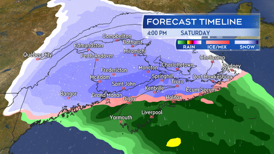
Snow develops Saturday morning through the afternoon. A turn to ice pellets and rain is expected for Atlantic coastal and southwestern Nova Scotia.
AMOUNTS
A highly varied accumulation of 5 to 15 cm is expected in the southwest and near Atlantic coastal areas of Nova Scotia due to the snow turning to ice pellets and, in some cases, rain. Higher snowfall amounts exceeding 25 cm are indicated for northern areas of the mainland extending east towards Sydney in Cape Breton.
Southern areas of New Brunswick, including Saint John and Moncton, are expected to see at least a 15 cm snowfall. Charlottetown into southern Kings County, P.E.I., could also finish near or above the 15 cm mark.
The forecast still has some uncertainty regarding how far north some of the heavier snow could reach.
Residents should see information provided by Environment Canada in any alerts issued for their area on Saturday morning.
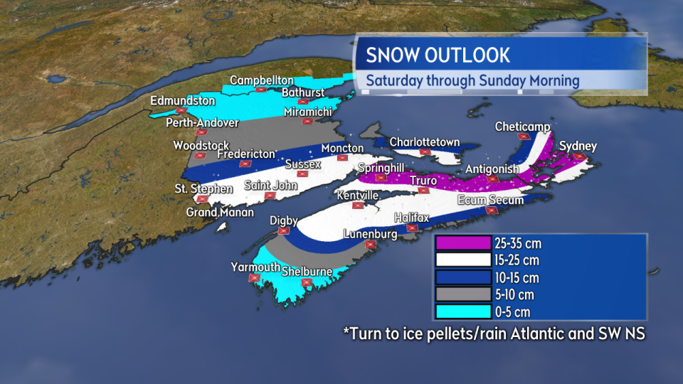
A heavy snowfall is expected for southern New Brunswick, eastern P.E.I., and much of northern/eastern Nova Scotia. A turn to ice pellets and rain reduces the snow accumulation for Atlantic coastal and southwestern Nova Scotia.
WIND
Increasing easterly winds will accompany the arrival of the system Saturday afternoon into the evening. Widespread regional gusts of 30 to 60 km/h can be expected, with gusts peaking as high as 60 to 80 km/h on the Atlantic coastline of Nova Scotia. Inverness County, Cape Breton could see gusts of 80+ km/h on Saturday night into early Sunday morning due to enhancement by the Highlands.
Blowing and drifting snow are likely to reduce visibility on roads.
The wind will turn north overnight and diminish Sunday morning through afternoon.
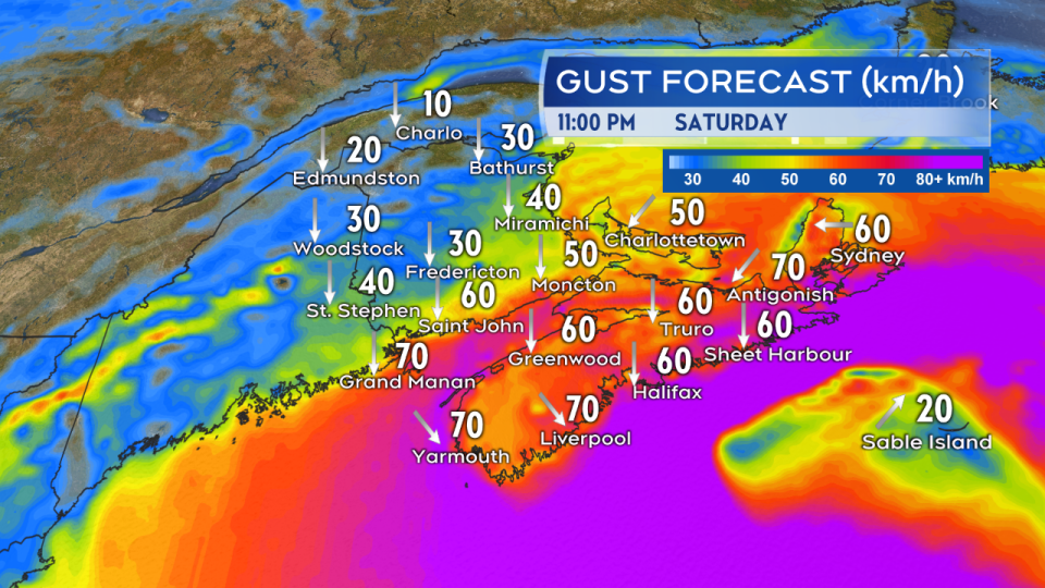
Easterly winds increase Saturday afternoon and evening before turning north and northwest Saturday night into Sunday morning. Widespread gusts 30 to 60 km/h with some areas peaking 60 to 80 km/h.
COASTAL/MARINE
While there is no current indication of a threat of coastal flooding, the building wind and falling pressure will lead to a rough and pounding surf.
Gale Warnings are in effect for most marine districts, with winds exceeding 35 knots likely. Seas of 3 to 6 metres are also forecast as the system moves through.
Individuals operating in marine areas should check a detailed marine forecast.
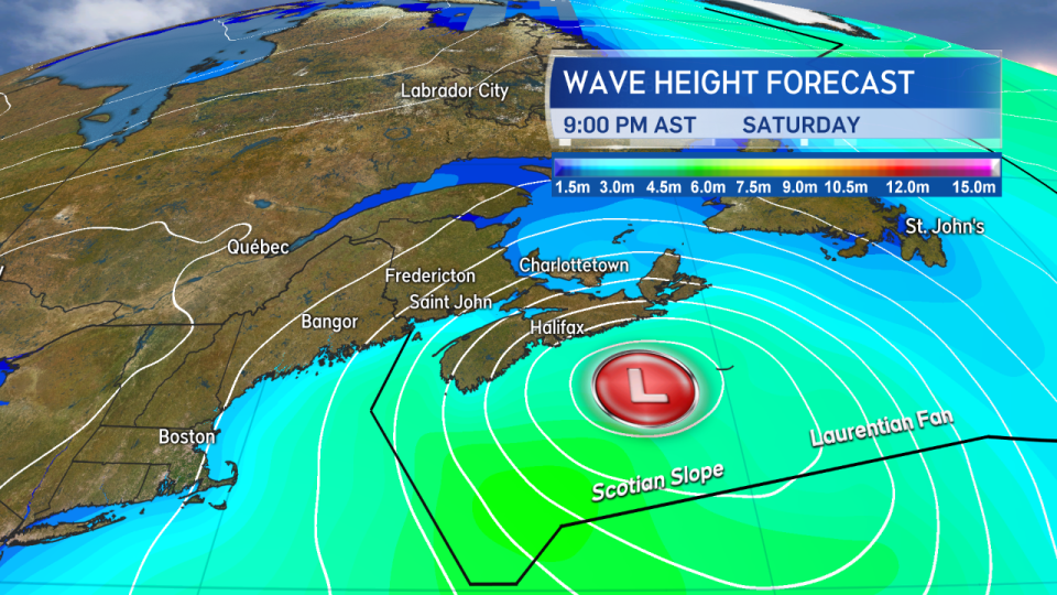
Gale force winds and building seas are expected upon approach and in the wake of the strengthening system as it passes just south and east of Nova Scotia.


