Post-tropical storm Lee hits the Maritimes with flooding, high waves and power outages
Post-tropical storm Lee has hit the Maritimes, bringing with it flooding, high waves and power outages affecting tens of thousands of homes Saturday.
The centre of post-tropical storm Lee made landfall at 5 p.m. Saturday on Long Island — an island in Digby County on the western coast of Nova Scotia. Areas of coastal Nova Scotia are experiencing significant storm surges, with waves crashing into roadways.
In the neighbouring Municipality of the District of Barrington, warden Eddie Nickerson said major waves have pummeled beaches, with ocean water covering coastal roads.
“The beach, it was quite a ball of waves there, bringing the stones over the road. It blocked a road off down there, and a pole was on fire on Stoney Island,” Nickerson said, referring to a community on Cape Sable Island.
Nickerson said Lee’s damage appears to have been less intense than anticipated, which is a relief to the region that was hard hit by wildfires earlier this summer.
In the sea-side community of St. Andrews, N.B., mayor Brad Henderson said it will require a lot of work to deal with the many large trees that have been downed by Lee.
“We’ve had a lot of trees that have been knocked down in our community, a lot of those have gone across roads and across power lines,” Henderson said in an interview Saturday.
That’s what happened to a power line out front of St. Andrews resident Allan Flewelling’s home. He said he heard a snap, and saw that a large tree from his lawn had toppled -- causing a small fire.
“We noticed the tree had fallen on the wires, caught fire. Then the mayor actually drove by shortly after that, and he called it in,” Flewelling said.
In Grand Manan, N.B., ferry service has been suspended between the island and mainland New Brunswick.
Grand Manan Mayor Bonnie Morse said in an interview Saturday Lee has hit the island with high winds and has felt “a lot like a good nor’easter storm.”
“But we seem to have survived everything okay so far,” Morse said around 4:30 p.m.
The mayor extended a thanks to Department of Transportation and Infrastructure crews, linesmen and NB Power crews for their ongoing work on the island.
“We’ve had a lot of trees down and roads blocked... But they seem to be keeping up reasonably well -- and given the weather conditions, that's saying a lot.
Yarmouth Mayor Pam Mood said in an interview around noon Saturday that the area is “not getting as hard a hit as we originally anticipated.”
“Lots of wind here -- there are some trees down, but far better than we thought,” she said.
IN PICTURES: Lee brings heavy winds to the Maritimes
As of about 10 p.m., there were more than 117,500 houses without power in Nova Scotia, about 18,500 customers in the dark in New Brunswick, and about 1,900 homes with no power on P.E.I.
No outages were reported by Newfoundland Power as of 7:45 p.m.
Matt Drover with Nova Scotia Power said in an interview Saturday crews are mobilized and working on restoring power in areas where winds are below 80 kilometres an hour.
“We’ve been preparing all week for this storm, we knew that Lee was going to be a significant storm with really high winds,” Drover said.
“Yesterday all of our crews from out of Nova Scotia arrived, we put them pretty much everywhere in the province -- recognizing that the western part of the province, the South Shore, the Valley, and also HRM would likely be hit the hardest.”
Erica Fleck, Halifax Regional Municipality’s emergency management director, is asking all residents to stay indoors and keep away from the coastline until the storm clears.
“It is really unsafe for people to be out there right now, we’re really urging residents to please be smart and stay home and shelter in place. There’s no need to be out right now unless it’s an absolute emergency,” Fleck said in an interview Saturday.
Fleck said that some roadways in the Lawrencetown area and the Eastern Shore have been “wiped out” by storm surges.
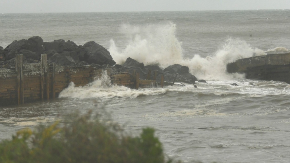 Waves crashing into a coastline in Digby, N.S., on Sept. 16, 2023, during post-tropical storm Lee. (CTV Atlantic/Sarah Plowman)
The storm was downgraded from a hurricane before it hit the region. The designation refers to the structure of the storm and does not indicate lessened impacts.
“Water has already crossed roads… Roads that were fixed during the fires and the floods between May and July are out again in the Peggys Cove area,” Fleck said.
“There are issues in Herring Cove, issues in Bedford, basically anywhere near water we’re already seeing issues, and the peak hasn’t come yet,” Fleck said around 12:30 p.m.
Nova Scotia RCMP are asking drivers to stay off the roads. Police said they've been receiving reports of drivers heading to the coast to watch the waves.
"This action is putting themselves at risk along with First Responders in the event of rescue attempts," said RCMP in a post on social media.
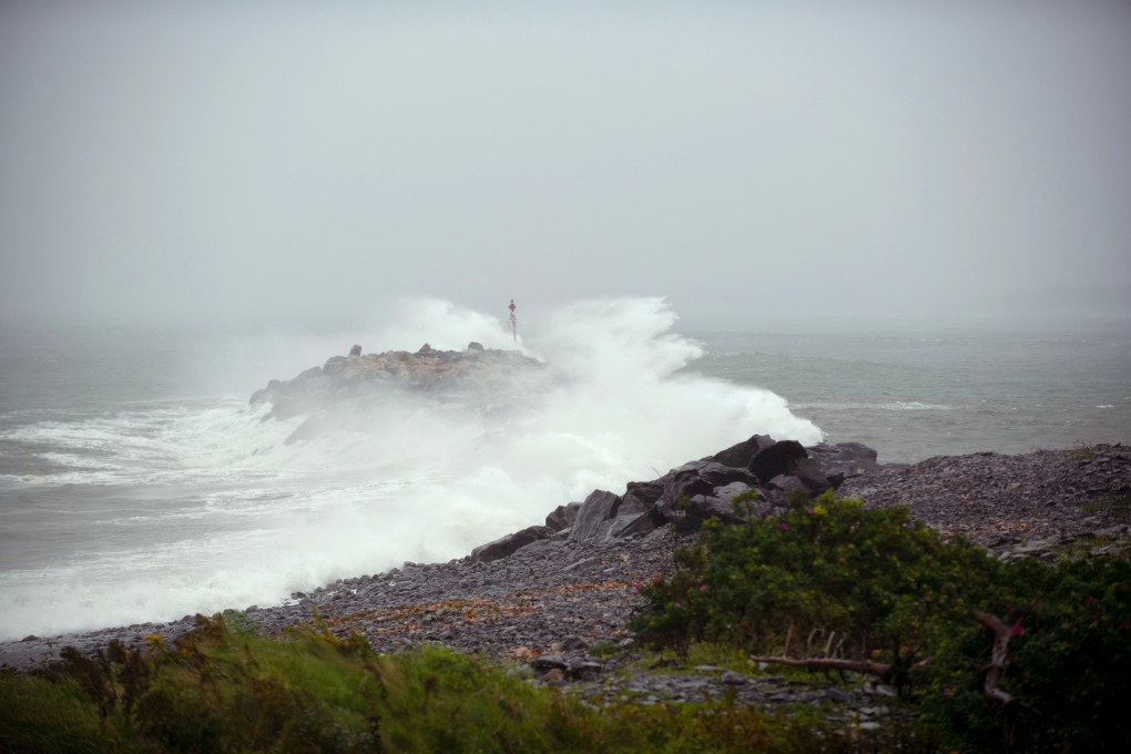 Waves crash against a breakwater in Port Maitland, N.S. as post-tropical cyclone Lee approaches on Saturday, Sept. 16, 2023. THE CANADIAN PRESS/Bill Curry
Environment Canada said that areas along Nova Scotia's central Atlantic coast could see breaking waves of between four and six metres, and storm surge warnings were in effect from Shelburne County eastward to Guysborough County.
In New Brunswick there are reports of flooding in some low-lying areas, including in Saint John and in Fredericton.
A couple historic trees believed to be more than 100 years old have been downed in uptown Saint John. City officials said in a statement that crews and arborists are addressing the sites on a priority basis and the public is asked to avoid driving around fallen trees and to use extreme caution in areas where crews are working.
Early Saturday a hurricane watch was in place for Grand Manan Island and coastal Charlotte County, N.B., and for most of Nova Scotia's Atlantic coast, stretching from Digby County through to Halifax County. A tropical storm warning also covered most of Nova Scotia and for New Brunswick's Bay of Fundy coast and parts of the province along the Northumberland Strait.
As of Saturday evening, the highest recorded wind gust by Environment Canada weather stations was 117 kilometres an hour, which was recorded at the Halifax Stanfield International Airport.
The storm was forecast to bring more than 100 millimetres of rain in some areas, and Environment Canada is warning of possible flooding in parts of southwestern Nova Scotia and New Brunswick, including Saint John and Moncton.
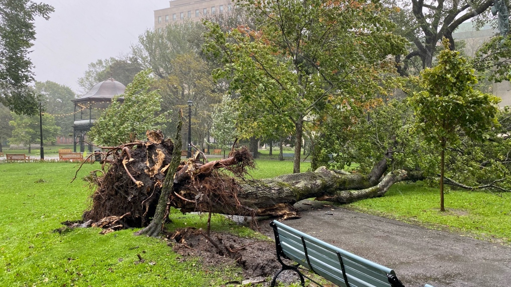 In Saint John N.B.'s Kings Square, a large tree has been knocked down as post-tropical storm Lee heads towards the region. Pictured Sept. 16, 2023. (CTV Atlantic/Avery MacRae).
“Though Lee has transitioned from a hurricane to a strong post-tropical cyclone, our concerns about the threat it poses are unchanged,” said Kyle Leavitt, New Brunswick's Emergency Measures Organization director, in a Saturday afternoon statement. “In fact, Lee has arrived faster and with slightly greater intensity than expected.”
On P.E.I., Public Safety Minister Bloyce Thompson is asking Islanders to “make final preparations” for the storm that is expected to hit the province later on Saturday.
“We know that this will not be as strong as storms that have impacted us over the previous few years, but we need to be sensible in preparing so that we are ready in any event. I urge Islanders to please stay inside during times of high winds, stay inland and away from coastal water,” Thompson said in a statement Saturday.
With files from The Canadian Press.
Click here for a photo gallery of the impact of post-tropical storm Lee in the Maritime provinces.
Shopping Trends
The Shopping Trends team is independent of the journalists at CTV News. We may earn a commission when you use our links to shop. Read about us.


CTVNews.ca Top Stories

W5 Investigates
W5 Investigates A 'ticking time bomb': Inside Syria's toughest prison holding accused high-ranking ISIS members
In the last of a three-part investigation, W5's Avery Haines was given rare access to a Syrian prison, where thousands of accused high-ranking ISIS members are being held.
'Mayday!': New details emerge after Boeing plane makes emergency landing at Mirabel airport
New details suggest that there were communication issues between the pilots of a charter flight and the control tower at Montreal's Mirabel airport when a Boeing 737 made an emergency landing on Wednesday.
Federal government posts $13B deficit in first half of the fiscal year
The Finance Department says the federal deficit was $13 billion between April and September.
Canadian news publishers suing ChatGPT developer OpenAI
A coalition of Canadian news publishers is suing OpenAI for using news content to train its ChatGPT generative artificial intelligence system.
Weather warnings for snow, wind issued in several parts of Canada
Winter is less than a month away, but parts of Canada are already projected to see winter-like weather.
BREAKING
BREAKING Supreme Court affirms constitutionality of B.C. law on opioid health costs recovery
Canada's top court has affirmed the constitutionality of a law that would allow British Columbia to pursue a class-action lawsuit against opioid providers on behalf of other provinces, the territories and the federal government.
Cucumbers sold in Ontario, other provinces recalled over possible salmonella contamination
A U.S. company is recalling cucumbers sold in Ontario and other Canadian provinces due to possible salmonella contamination.
Nick Cannon says he's seeking help for narcissistic personality disorder
Nick Cannon has spoken out about his recent diagnosis of narcissistic personality disorder, saying 'I need help.'
Real GDP per capita declines for 6th consecutive quarter, household savings rise
Statistics Canada says the economy grew at an annualized pace of one per cent during the third quarter, in line with economists' expectations.
Toronto
-

Black Friday sales stretch out for weeks: retail analyst
Black Friday is officially the busiest shopping day of the year, even surpassing Boxing Day and Super Saturday, the final Saturday before Christmas. Analysts say retailers are rolling out Black Friday sales sooner now, making them last longer into Cyber Monday and beyond.
-
Cucumbers sold in Ontario, other provinces recalled over possible salmonella contamination
A U.S. company is recalling cucumbers sold in Ontario and other Canadian provinces due to possible salmonella contamination.
-
House fire in North York sends 6 people to hospital
Six people are in hospital as a precaution after a fire broke out in a North York home overnight.
Calgary
-
 BREAKING
BREAKING Calgary Mayor Jyoti Gondek running for re-election
Calgary Mayor Jyoti Gondek has announced she will run for re-election in the next municipal election in 2025.
-
Multiple crashes reported on Deerfoot Trail
Calgary police say there are at least three major crashes on Deerfoot Trail on Friday morning as frigid overnight temperatures likely led to icy conditions in many areas.
-
Black Friday deals look to appeal to budget-friendly Calgary shoppers
Black Friday sales are in full swing as annual holiday shopping returns and Calgary retailers are competing harder than ever to coax budget-conscious shoppers into a deal.
Edmonton
-

Oilers rightly optimistic they can pull themselves into NHL playoff picture. Again
Hockey fans know the adage: U.S. Thanksgiving, while unofficial, serves as a great calendar marker in predicting which teams will make the National Hockey League playoffs.
-
ATV driver killed in crash on Sturgeon Lake Cree Nation
A 31-year-old man was killed in a crash on Sturgeon Lake Cree Nation on Thursday.
-
WEATHER
WEATHER Josh Classen's forecast: A few more cold and snowy days, then the deep freeze breaks
We'll close out November with two more frigid days and Sunday doesn't look much warmer.
Montreal
-

Quebec trying to 'minimize' impact of health care cuts on services
Eliminating $1.5 billion in health care spending is likely to have an impact on services, but Quebec says it will try to 'minimize' it.
-
One woman killed, one hurt in armed robbery attempt southeast of Quebec City
One woman was killed and another was badly injured following an alleged armed robbery attempt at a clothing store southeast of Quebec City.
-
'Mayday!': New details emerge after Boeing plane makes emergency landing at Mirabel airport
New details suggest that there were communication issues between the pilots of a charter flight and the control tower at Montreal's Mirabel airport when a Boeing 737 made an emergency landing on Wednesday.
Ottawa
-

'Dude, Where's My Bus?' Ottawa man fed up with OC Transpo makes documentary exploring transit troubles
Gio Petti put together a documentary on OC Transpo, asking how we got here. How did a city that was once lauded as an example of how to do transit right, and that boasted some of the highest per capita transit ridership numbers in the country, become a system that now elicits so much frustration from users?
-
Ottawa police charge two adults, teenager following Orleans kidnapping and robbery
The Ottawa Police Service says two adults and a teenager are facing multiple charges following a kidnapping, robbery and extortion incident that happened last month in Orleans.
-
Ottawa to begin full enforcement of 3-item garbage limit on Monday: Here’s what you need to know
The City of Ottawa will begin the final phase of the graduated approach to enforcing the city’s new three-item garbage limit on Monday, leaving behind any extra items not in a yellow bag.
London
-

Sarnia police lay charges after women wakes up to naked man in her home
An arrest has been made after a break and enter call in Sarnia where a woman woke up to a naked man in her home. Police said after investigating, officers were able to identify a 26-year-old man who was also wanted on an outstanding warrant in London.
-
Knights' Boulton hit with eight-game suspension
The left winger has been suspended eight games, retroactive to Nov. 23 against Saginaw, when he was handed a major penalty for slashing, along with a game misconduct.
-
'Shock, disappointment, and excitement': South Bruce not selected for nuclear waste project
Anja Vandervlies and Michelle Stein could hardly believe it when they heard South Bruce was not going to host Canada’s first permanent storage facility for nuclear waste.
Barrie
-

50 cms of snow across central Ontario expected this weekend
Environment Canada has released snow squall warnings and watches for our region.
-
Individuals living in encampment in Barrie's south end given notice to vacate
Several police officers and city staff attended a homeless encampment in Barrie’s south end on Thursday morning to inform the individuals living there they would have to vacate the area.
-
Here are the school buses cancelled as wintry weather arrives
The winter weather has arrived, and with it come the first school bus cancellations of the season.
Northern Ontario
-

Another 50 cm of snow possible in the Sault as severe weather continues
Closures and cancellations are piling up in Sault Ste. Marie as a major winter storm continues for another day Friday.
-
Ongoing bed bug issue at a Timmins apartment building is 'like living in hell'
A battle with bed bugs continues at 217 Pine St. North in Timmins, according to a tenant who has lived there for a year and a half.
-
California man who went missing for 25 years found after sister sees his picture in the news
It’s a Thanksgiving miracle for one California family after a man who went missing in 1999 was found 25 years later when his sister saw a photo of him in an online article, authorities said.
Kitchener
-

One dead, another hurt in Cambridge shooting
Waterloo Regional Police are investigating a fatal shooting in Cambridge.
-
Police looking for missing teen last seen in Cambridge
Waterloo Regional Police are looking for information about the whereabouts of a missing teen.
-
Mother from Guelph, Ont. seeks answers following son's death in prison
Brody Robinson was found without vital signs in his cell at Millhaven Institution the evening of Oct. 29. He was 23-years-old.
Windsor
-
 Breaking
Breaking Windsor man convicted on all counts by Chatham judge
The Windsor man charged in connection to the double fatal Retrofest collision has been convicted on all counts.
-
Windsor man charged in child pornography investigation
A Windsor man has been charged following a child pornography investigation.
-
Lakeshore announces new CAO
The Municipality of Lakeshore will have a new Chief Administrative Officer in the new year.
Winnipeg
-

Hanover School Division laying off 93 EAs due to confusion over funding
The Hanover School Division is laying off 93 educational assistants, citing an "unexpected loss of federal funding for Jordan's Principle programming."
-
Water main break causing Friday morning traffic delays in Winnipeg
Winnipeg drivers are being warned of traffic delays on Friday morning due to a water main break.
-
A tale of two downtowns: Restaurants opening and closing show complexity of downtown revival
Proposed developments and new businesses opening are fueling optimism for some on a revival of downtown Winnipeg, but some business owners say the present remains problematic.
Regina
-

Crown gives final remarks in Ruben Manz case as argument to jury concludes
The prosecution has presented their closing remarks against Ruben Manz to a 13-person jury, bringing an end to arguments before their sequestering.
-
Youngest roping duo looking for repeat performance at Agribition Rodeo
Kavis Drake, 18, and Denim Ross, 20, won the average in last year’s Maple Leaf Finals Rodeo team roping event at Agribition. The two were the youngest competitors in 2023 and are once again in their event this year.
-
Canada Post temporarily laying off striking workers, union says
The union representing Canada Post workers says the Crown corporation has been laying off striking employees as the labour action by more than 55,000 workers approaches the two-week mark.
Saskatoon
-

Ontario men arrested after Saskatoon police seize 16 kilos of meth, nearly $70K in cash
Saskatoon police say officers arrested three 20-year-old men Wednesday afternoon and seized nearly $70,000, in cash as well as various illicit drugs.
-
Extreme cold warning issued for Saskatoon
Environment Canada has issued an extreme cold warning for parts of central Saskatchewan, including Saskatoon, on Thursday.
-
Sask. forecasting $743.5M deficit in mid-year financial report, up $470.5M from budget
The provincial government says increases to crop insurance claims later in the growing season are a main reason for Thursday’s mid-year deficit forecast of $743.5 million, which is up more than $470 million from the budget.
Vancouver
-

Surrey Police Service officially takes over from the RCMP after years-long saga
The years-long saga over who will police the city of Surrey has reached its final chapter.
-
How changing catch-and-release fishing practices can boost salmon survival
A study has found catch-and-release sportfishing practices that leave salmon with injuries, particularly to their eyes, cause higher mortality than earlier research suggested.
-
BREAKING
BREAKING Supreme Court affirms constitutionality of B.C. law on opioid health costs recovery
Canada's top court has affirmed the constitutionality of a law that would allow British Columbia to pursue a class-action lawsuit against opioid providers on behalf of other provinces, the territories and the federal government.
Vancouver Island
-

How changing catch-and-release fishing practices can boost salmon survival
A study has found catch-and-release sportfishing practices that leave salmon with injuries, particularly to their eyes, cause higher mortality than earlier research suggested.
-
BREAKING
BREAKING Supreme Court affirms constitutionality of B.C. law on opioid health costs recovery
Canada's top court has affirmed the constitutionality of a law that would allow British Columbia to pursue a class-action lawsuit against opioid providers on behalf of other provinces, the territories and the federal government.
-
Avian flu case discovered in Greater Victoria, officials confirm
The Canadian Food Inspection Agency (CFIA) has confirmed a case of avian flu has been detected in Greater Victoria, on the Saanich Peninsula.
Kelowna
-

Kelowna, B.C., to host the Memorial Cup in the spring of 2026
The Western Hockey League's Kelowna Rockets will host the Memorial Cup in the spring of 2026, the Canadian Hockey League said Wednesday.
-
545 vehicles impounded in 332 days: BC Highway Patrol pleads for drivers to slow down
Mounties with the BC Highway Patrol in Kelowna say they've impounded more than 545 vehicles for excessive speed and aggressive driving so far this year. That works out to more than 1.6 per day.
-
Man in hospital following targeted shooting in Kamloops
Police are appealing for information on a targeted shooting that resulted in the hospitalization of a man in Kamloops.


