
What a sweltering weekend it was for the Maritimes, ending with a bang as round of thunderstorms crossed on Sunday.
The region was in the running for hottest spot in the country Sunday with a high temperature of 33.8 C reported at Kejimkujik National Park in Nova Scotia (feeling 45 with the humidex!) only just beat out by Lytton, B.C., which reached 34.5 C. While down from the weekend the sultry weather hasn't completely broken yet. Heat warnings linger Monday for the South Shore of Nova Scotia and many will be warm and muggy Monday evening. That changes Tuesday as a cold front sweeps through.
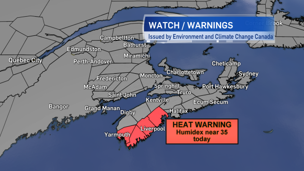
Heat warnings linger today for the South Shore of Nova Scotia. Humidex values will approach 35.
Clouds will increase across the Maritimes Monday night accompanied by fog patches and showers moving in near and after midnight. A round of rain with embedded downpours and thunderstorms crosses Nova Scotia and brushes southern New Brunswick and eastern P.E.I. Tuesday morning and afternoon. Rainfall amounts will be variable across the Maritimes.
Little rain is expected for northern and central New Brunswick as well as western Prince Edward Island where showers are likely to contribute only a few millimetres. Higher rainfall totals are forecast along the Bay of Fundy coastline in New Brunswick, eastern P.E.I., and across Nova Scotia. For those areas local rainfall amounts will range 20 to 40 mm. Totals near 40 mm look most widespread for Nova Scotia particularly running up the Valley, across the North Shore, and into Cape Breton.
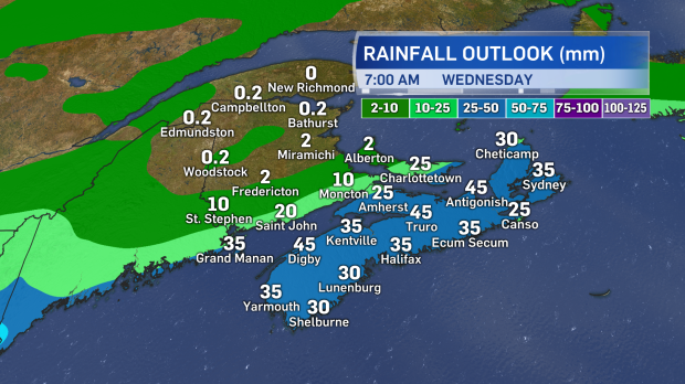
Rain and showers Tuesday. The heaviest rain for Nova Scotia, southern New Brunswick, and eastern Prince Edward Island. Much lighter elsewhere.
Rain is not a bad thing at this point, though, as a large area of high pressure will move into place late week and is forecast to last the weekend. That means after a few spotty showers Wednesday, conditions are expected to be largely sunny from Thursday until next Monday.


