Maritimers were preparing Monday for a powerful Nor’easter that’s expected to hit the region overnight.
Some parts of the U.S. have already declared states of emergency due to the storm that’s expected to bring up to 100 centimetres of snow to parts of the New England states.
In Atlantic Canada, where the snow is forecasted to be less deep and mixed with freezing rain, cancellation announcements were already coming in on Monday evening.
CTV Atlantic meteorologist Cindy Day described the Nor’easter as “clipper-like”, saying the system is expected to deepen as it swings out into the mid-Atlantic Ocean.
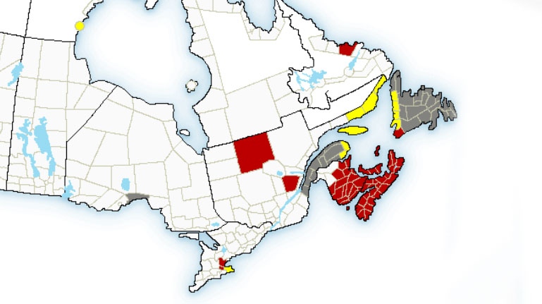
In New Brunswick, residents can expect snow and wind — blizzard warnings are in place for the entire province, except the northwest corner.
The first snowfall there is expected to start around 2 a.m. in Saint John, and just before sunrise in Fredericton and Moncton.
Moncton and southeastern New Brunswick are expected to get the biggest white wallop, with 30 to 40 centimetres of snowfall forecasted.
Fredericton and Saint John should see 25-30 centimetres of snow.
Whiteout conditions are expected for some parts of the province, with north-east winds gusting up to 90 km/h.
The weather is expected to be a bit more complex in Nova Scotia, where the whole province is under a blizzard warning, with the exception of Shelburne and Yarmouth counties.
Snow and wind will be on the menu there for many hours, followed by several hours of ice pellets and freezing rain in coastal regions later in the day.
Yarmouth and the southwestern part of the province should expect the snow to begin just after midnight, accumulating to 10-15 centimetres before changing to a mix of snow and freezing rain by about 11 a.m.
The snow will reach the Annapolis Valley and the Halifax area by about 5 a.m., arriving in Cape Breton after 9 a.m.
The Valley and most of the northern mainland should get 25-30 centimetres of snow.
Along the Atlantic coast, the snow is expected to change to a messy mix of snow and freezing rain.
Halifax should get about 20 centimetres before the rain enters the mix in the early evening.
Sydney could get up to 15 centimetres of snow before ice pellets and freezing rain take over late in the day.
North-easterly wind will be an issue in Nova Scotia, blowing between 60 and 80 km/h and with gusts reaching 110 km/h in coastal regions.
Nova Scotia Power is warning its customers that these high winds pose a threat to the grid.
“It might also be unsafe for our crews to go up in the bucket lifts if the winds remain high,” said NSP spokeswoman Beverley Ware.
“So we want our customers to know if those conditions do develop as predicted at this point they may have extended power outages,” she said.
Hospitals in the Nova Scotia were in the process of crafting contingency plans on Monday, but had made no final cancellation decisions by Monday evening.
“We don't plan on cancelling anything in advance. The intention is to make decisions as close to the possible storm as possible,” said Capital Health spokesman Everton McLean, adding that such decisions can be expected to come down early Tuesday morning.
Schools in the region are also making preparations, as some high schools are in the midst of exams.
A spokesperson for the Halifax Regional School Board said decisions about school closures will be made as close as possible to 6 a.m. Tuesday morning.
With files from CTV Atlantic's Jayson Baxter


