
HALIFAX -- A quick moving low-pressure system will cross the Great Lakes before moving across the Maritimes and into Newfoundland on Friday.
The system will bring a mix of snow, freezing rain, and rain along with some high winds during its passage.
The first of the snow will arrive in New Brunswick late Friday morning through noon. By evening, that snow will have turned to rain for all but northern areas of New Brunswick. A mix of snow turning to rain will reach Prince Edward Island in the evening turning to rain for the night. Nova Scotia will see rainy and windy weather for the evening and night, with a bit of snow to start for northern and eastern areas including Cape Breton.
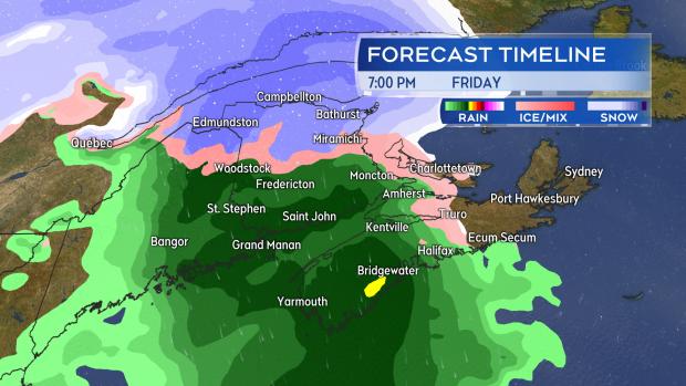
A mix of snow, freezing rain, and rain develops across the Maritimes Friday afternoon and evening. The rain-snow line will eventually push all the way up into northern New Brunswick.
The most snow accumulation is expected in the northern most areas of New Brunswick. The area along and north of a line from Grand Falls to Bathurst can expect widespread amounts of 15 to 25 cm. Just to the south a slushy, icy mix of five to 10 cm will be present including communities such as Woodstock and Miramichi. The rest of New Brunswick, and the Maritimes, can expect just rain or a quick turn to rain with totals of 10 to 25 mm.
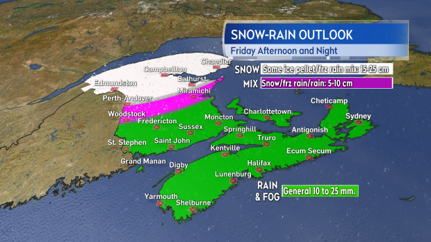
The most snow is forecast for northern areas of New Brunswick. Much of the remainder of the Maritimes can expect 10 to 25 mm of rain.
Wind will also be a factor for parts of the Maritimes on Friday. Ramping up through the day, it will hit peak gusts out of the southeast Friday evening and night. Gusts of 80 to 100 km/h can be expected on the Bay of Fundy coastline in New Brunswick, and up and down the Atlantic coastline of Nova Scotia. Due to the topography of the Highlands on Cape Breton Island, gusts in northern Inverness County are likely to reach 130 km/h or stronger. Winds turn west and southwest early Saturday morning but continue with gusts between 50 and 80 km/h.
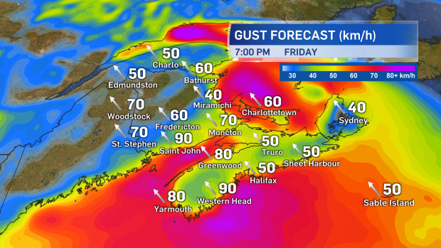
Winds increase from the southeast peaking with widespread gusts of 50 to 80 km/h Friday evening and night. Stronger gusts are a risk for coastal areas as well as Inverness County.
Snowfall warnings have been issued for northern areas of New Brunswick with a special weather statement remaining in place for much of the rest of that province. It also extends up the Atlantic coastline of Nova Scotia and across Cape Breton Island.
Takeaways:
- A mix of snow and rain builds into the Maritimes on Friday afternoon and evening.
- The most snow is expected in northern most areas of New Brunswick with general totals of 15 to 25 cm. Other areas of New Brunswick, P.E.I., and Cape Breton could see a bit of snow/freezing rain to start before a turn to rain.
- The rain will total 10 to 25 mm for much of the Maritimes.
- Winds peak with southeasterly gusts 50 to 80 km/h Friday evening and night. Gusts in excess of 80 km/h are possible for coastal areas as well as Inverness County.


