Mix of snow and rain expected for the Maritimes Thursday
HALIFAX -
A combination of snow, rain and wind warnings have been issued for the Maritimes by Environment Canada.
In New Brunswick, a snowfall warning is in effect for much of the northern half of the province, where rapid snow accumulation is expected to make travel difficult Thursday.
Rainfall warnings extend across southwestern New Brunswick and across mainland Nova Scotia. For those areas, higher rainfall amounts may combine with snow melt to increase the risk of hydroplaning conditions and localized flooding.
A wind warning blankets Nova Scotia and Prince Edward Island. It’s also in effect for the Acadian Peninsula and coastal Charlotte County in New Brunswick.
A strong southerly wind may peak with widespread gusts of 60 to 80 kilometres per hour, and 80 to 100 kilometres per hour winds on exposed areas of the coast and higher terrain.
Stronger gusts of 130 kilometres are expected Margaree Harbour to Bay St. Lawrence in Cape Breton due to the topography of the Highlands.
The strong wind will drive a rough and pounding surf on the coast and give a risk of scattered power outages.
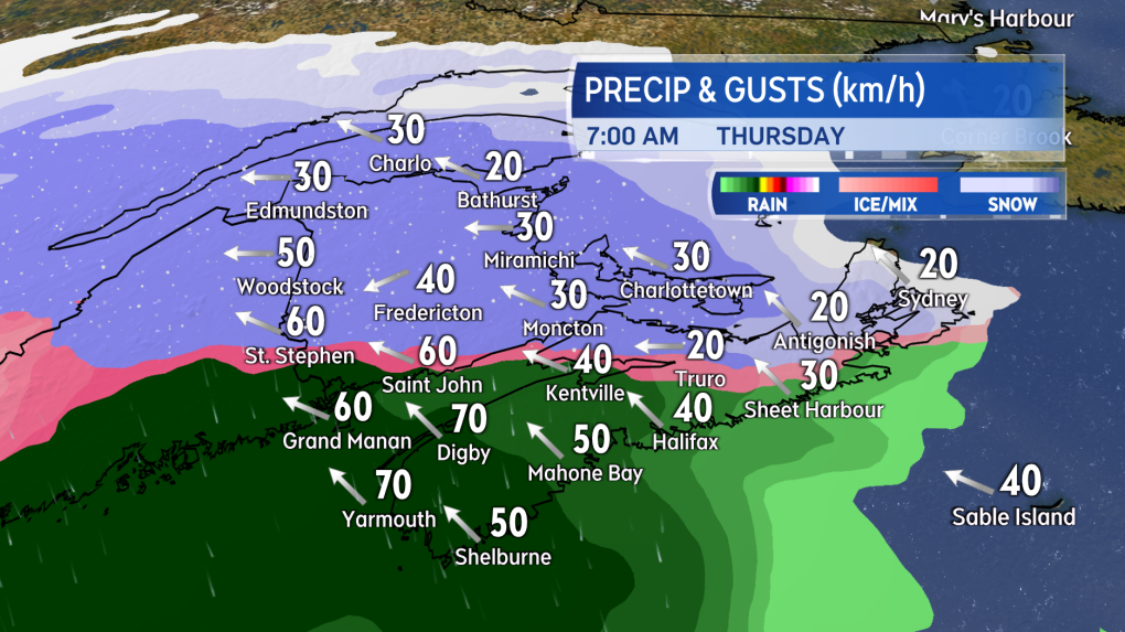
THURSDAY MORNING
Snow will arrive in western New Brunswick and southwestern Nova Scotia near midnight.
By early Thursday morning, a moderate-to-heavy snow will be falling across New Brunswick, Prince Edward Island, and northern areas of Nova Scotia.
Snow turning to rain along the Bay of Fundy coastline in New Brunswick and in western Nova Scotia. Central and northern areas of New Brunswick will see snow amounts climb to and in excess of 10 centimetres quickly.
Expect driving conditions to deteriorate just a few hours after the snow begins to fall.
Wind will be southeast, except east in northern areas of New Brunswick. Gusts will increase into a range of 40 to 60 kilometres per hour, except 70 to 90 kilometres per hour for coastal areas of southwestern New Brunswick and southwestern Nova Scotia.
 Snow and rain will quickly spread across the Maritimes Thursday morning.
THURSDAY AFTERNOON
Snow will have turned to rain by early Thursday afternoon for all but the northernmost area of New Brunswick.
Communities from Edmundston and Grand Falls, Campbellton-Dalhousie, and Bathurst will still be in a mix of snow, ice pellets and freezing rain. Precipitation rates will be high with visibility reduced and hydroplaning conditions on roads.
The wind will be prevailing from the south for most of the Maritimes. Gusts will have increased into a range of 50 to 80 kilometres per hour, except 80 to 100 kilometres on the coast and at higher terrain.
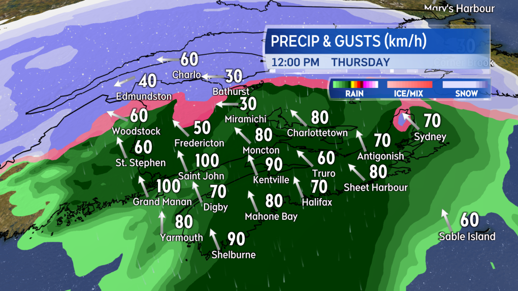 In the thick of the inclement weather, snow and rain rates will be high and southerly winds increasingly strong.
THURSDAY EVENING AND NIGHT
Rain and snow will ease to patchy areas of flurries, showers, and drizzle by late evening. The light and scattered precipitation will continue into the overnight hours.
Temperatures will fall back below freezing for all three Maritime provinces.
Watch for wet or slushy surfaces to turn icy for Friday morning. Wind direction will be west to southwest. Peak gusts will come down into a range of 40 to 70 kilometres per hour. Wind will diminish further through Friday morning with westerly gusts in a range of 30 to 50 kilometres per hour by near noon.
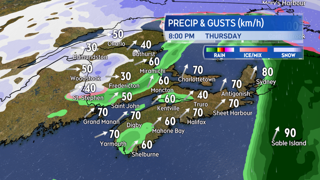 Precipitation becomes lighter and more scattered in coverage Thursday night. Icy surfaces are expected by Friday morning as temperatures fall back below freezing.
SNOW AND RAIN AMOUNTS
The most snow and ice pellet accumulation is expected in the area of New Brunswick from about Woodstock to Miramichi and north.
Snow amounts could reach 20 to 30 centimetres, even though some mixing in of freezing rain and rain looks likely, which will make for heavier snow removal.
Fredericton and central areas of New Brunswick could pick up an initial 10 to 20 centimetres of snow before the turn to rain.
Progressively lower snow amounts are expected for southern areas of New Brunswick, Prince Edward Island and Nova Scotia as the turn to rain will be quicker.
Rain totals of 30 to 50 millimetres are expected in southwestern New Brunswick and across much of Nova Scotia. Local rain amounts of 50 to 70 millimetres are possible along the Atlantic coastline of Nova Scotia. Frozen and saturated ground will increase the amount of water runoff during the rain.
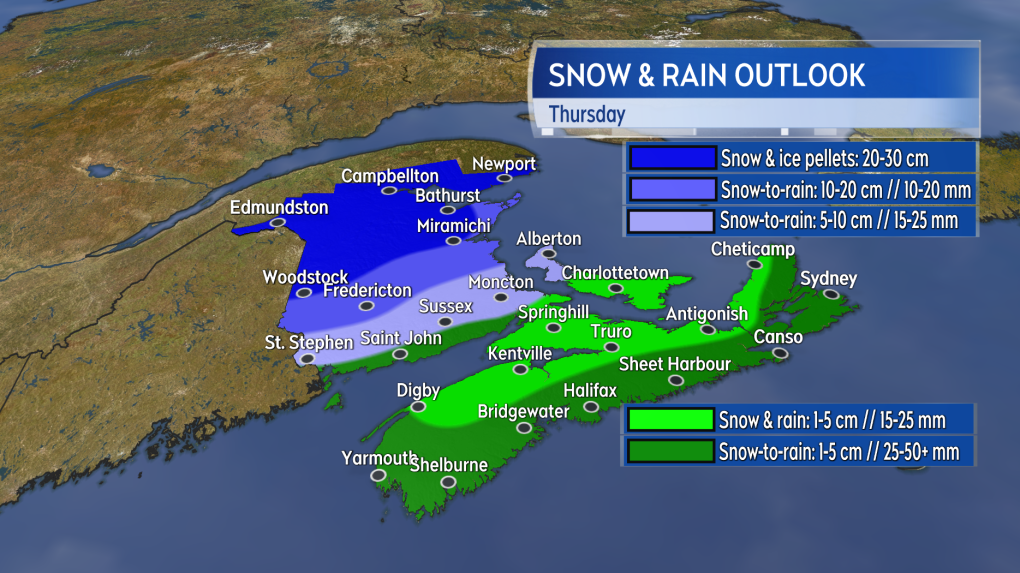 The most snow is expected in northern areas of New Brunswick, with much of the rest of the region seeing a quicker turn from snow to rain.
TRAVEL
The Confederation Bridge, Bay Ferries, Marine Atlantic and Tancook Ferry have stated closures may be possible Thursday, affecting travel.
Cancellations are expected Thursday across the region given the deteriorating conditions. Travelers are reminded to check ahead before heading out.
Shopping Trends
The Shopping Trends team is independent of the journalists at CTV News. We may earn a commission when you use our links to shop. Read about us.


CTVNews.ca Top Stories

DEVELOPING
DEVELOPING Disturbing video shows moment U.S. health-care CEO gunned down
UnitedHealthcare CEO Brian Thompson was killed Wednesday morning in what investigators suspect was a targeted shooting outside a Manhattan hotel where the health insurer was holding an investor conference.
BREAKING
BREAKING Multiple people stabbed in downtown Vancouver: police
A 'number of people' were stabbed in downtown Vancouver Wednesday before the suspect was shot by police, authorities say.
Warm, wet winter expected in much of Canada, say forecasters
Federal forecasters expect a warmer-than-normal start to winter in most of Canada, with more precipitation than usual in parts of the country.
Air Canada to bar carry-on bags for lowest-fare customers
Air Canada plans to bar carry-on bags and impose a seat selection fee for its lowest-fare customers in the new year.
French government toppled in historic no-confidence vote
French opposition lawmakers brought the government down on Wednesday, throwing the European Union's second-biggest economic power deeper into a political crisis that threatens its capacity to legislate and rein in a massive budget deficit.
Why are some Canada Post outlets still open during CUPW strike?
As many postal workers continue to strike across the country, some Canadians have been puzzled by the fact some Canada Post offices and retail outlets remain open.
opinion
opinion Tom Mulcair: The one place in Canada where Poilievre can't break through is Quebec
Former NDP leader Tom Mulcair says Pierre Poilievre has only himself to blame for his poor performance in the polls in Quebec.
$80-million jackpot: 2 winning tickets sold in Canada
There are two winners of the $80 million Lotto Max jackpot, Ontario Lottery and Gaming (OLG) has announced. The prize will be split between two tickets sold in Quebec and Alberta, respectively.
2 Quebec men top Bolo Program's latest Top 25 list of Canada's most wanted
Two men believed to be central figures in Quebec’s violent and ongoing drug conflict topped the Bolo Program's latest Top 25 list of Canada's Most Wanted fugitives.
Toronto
-
 LIVE UPDATES
LIVE UPDATES Toronto under winter weather travel advisory
Toronto is getting its first taste of winter weather Wednesday as a low-pressure system brings snow to the city. Environment Canada issued a winter weather travel advisory on Tuesday night, warning of potentially hazardous driving conditions throughout the day.
-
5 individuals wanted for GTA-area murders added to Canada’s most-wanted fugitives list
Five individuals being sought by police in the GTA have been added to a list of Canada’s most wanted fugitives.
-
BREAKING
BREAKING Multiple people stabbed in downtown Vancouver: police
A 'number of people' were stabbed in downtown Vancouver Wednesday before the suspect was shot by police, authorities say.
Calgary
-
 WATCH LIVE
WATCH LIVE Former Calgary police officer wanted on Canada-wide warrant
Calgary police have issued a Canada-wide warrant for a former officer they say used police resources to contact women he met while on duty.
-
'Dangerous and unpredictable' Calgary man among Canada's 25 most wanted fugitives
A Calgary man accused of killing a mother of five in a senseless act of violence remains one of the most wanted criminals in Canada.
-
Air Canada to bar carry-on bags for lowest-fare customers
Air Canada plans to bar carry-on bags and impose a seat selection fee for its lowest-fare customers in the new year.
Edmonton
-

Lucy the elephant in good health, but should remain in Edmonton: experts
Lucy the elephant is in good health and able to travel – though experts recommend she stays put.
-
Edmonton man apologizes in wrong-way crash that killed Toronto woman
The man responsible for a crash that killed a Toronto woman last year faced her family in court on Tuesday.
-
Suspects in West Edmonton Mall, lounge shootings among Canada's most wanted
Edmonton police on Wednesday released the name and photo of a man wanted across the country for his alleged role in the 2023 shooting at West Edmonton Mall.
Montreal
-

2 Quebec men top Bolo Program's latest Top 25 list of Canada's most wanted
Two men believed to be central figures in Quebec’s violent and ongoing drug conflict topped the Bolo Program's latest Top 25 list of Canada's Most Wanted fugitives.
-
Bill to force new Quebec doctors to stay in province raises legal questions: expert
A constitutional expert says proposed Quebec legislation to force new doctors to practise in the province's public system for five years after they graduate could potentially violate Charter-guaranteed rights to freedom of movement.
-
Quebec updates list of 'designated' English speaking, multilingual health centres
Quebec has updated its official list of English speaking and multilingual health centres.
Ottawa
-
 WINTER WEATHER TRAVEL ADVISORY
WINTER WEATHER TRAVEL ADVISORY 10 cm of snow in the forecast, OPP urging drivers to drive safely in Ottawa and eastern Ontario
Cold temperatures and snow amounting to 10 centimetres are in the forecast for Ottawa this Wednesday. A winter weather travel advisory is in effect and police are asking people to drive safely.
-
Ottawa's chief medical officer Dr. Vera Etches to become head of CHEO
Ottawa’s medical officer of health Dr. Vera Etches has been appointed as the president and CEO of the Children's Hospital of Eastern Ontario (CHEO).
-
Two suspects in Ottawa homicides on Canada's most wanted list: Bolo Program
Two suspects in separate homicides in Ottawa are on Canada’s most wanted list issued by The Bolo Program.
London
-

Police seize fentanyl, cocaine, and more in search of Exeter property
A drug trafficking investigation which concluded in a search warrant has resulted in charges for two men in Exeter.
-
Boler Mountain hopes to debut multi-million-dollar expansion at opening next week
This week’s winter weather has accelerated opening day plans for an expanded Boler Mountain. Since temperatures dropped snowmaking machines have been running most days and every night.
-
Air Canada to bar carry-on bags for lowest-fare customers
Air Canada plans to bar carry-on bags and impose a seat selection fee for its lowest-fare customers in the new year.
Barrie
-

Midland man accused of violent sexual assaults denied bail after 2nd arrest
A Midland man accused of violent sexual assaults who was granted bail last month has been arrested again, but this time, he will remain behind bars.
-
Snow hammers parts of Muskoka as residents continue digging out
Cold, wintery weather has landed in the Huntsville and Lake of Bays in Muskoka.
-
Barrie man couldn't believe his luck after winning nearly $112,000 with Lotto Max
A Barrie man is celebrating his first big win with Lotto Max, even if it took him a minute to realize his good fortune.
Northern Ontario
-

Hwy. 11 closed in different areas between North Bay and Hearst
Bad weather has closed Highway 11 between Hearst and Longlac, the Ontario Provincial Police said Wednesday.
-
Snow-clearing efforts stalled due to tractor-trailers stuck on many roads along Highway 11
Snow-clearing efforts continue on secondary roads that remain closed along Highway 11 on Tuesday.
-
Air Canada to bar carry-on bags for lowest-fare customers
Air Canada plans to bar carry-on bags and impose a seat selection fee for its lowest-fare customers in the new year.
Kitchener
-

Guelph schools in lockdown
Two elementary schools in Guelph are in lockdown and a third is in hold-and-secure for an ongoing investigation.
-
Waterloo Regional Police recover 52 vehicles from chop shop in North Dumfries, Ont.
A chop shop in North Dumfries, Ont. has been dismantled after police found 52 stolen vehicles.
-
Three 13-year-olds fall through ice at Cambridge pond
The Waterloo Regional Police Service has issued a public plea after three boys fell through the ice at a Cambridge pond on Tuesday.
Windsor
-

Windsor business profiting big from Canada Post strike
Most local businesses have found alternative ways to ship their products to customers during the Canada Post Strike.
-
'We just want to make sure every child is covered': Street Help assisting youth this holiday season
Officials at the Street Help Homeless Centre on Wyandotte Street have posted a list online with first names, ages and genders of dozens of children and teenagers, hoping members of the community can help with Christmas gift donations.
-
34-year-old Chatham woman dies after crash
Chatham-Kent police say a 34-year-old woman has died after a crash in Ridgetown.
Winnipeg
-

Proposed site for Winnipeg supervised consumption site in the city's core
The province’s first supervised consumption site could soon be located along the Disraeli Freeway in Winnipeg.
-
The Forks offering partial parking ticket forgiveness in exchange for river trail help
Have an outstanding parking ticket from The Forks? You might be able to save a little money.
-
Winnipeg looking for company to process Green Cart organic waste
The City of Winnipeg is searching for a company to process organic waste collected through its upcoming Green Cart program.
Regina
-

Is your water changing colour and taste? Don't worry, its still safe
Residents in Regina and Moose Jaw may notice some changes in their water as construction continues at the Buffalo Pound Water Treatment Plant.
-
Sask. auditor says high social housing vacancy rates in Regina need to be addressed
Saskatchewan's auditor says Regina had nearly 18 per cent of all social housing vacancies in the province at one point in 2024.
-
Maddox Schultz, 14, leading U18 AAA hockey league in points
Maddox Schultz continues to prove that he can play with the best of the best as the youngest player to suit up for every game for the U18 AAA Pat Canadians so far this season.
Saskatoon
-

Saskatoon boy, 16, faces first-degree murder charge in death of woman found outside the Copper Mug
A 16-year-old boy faces a first-degree murder charge in the case of a woman found dead in an 8th Street parking lot last month.
-
'It's just way better': Saskatchewan hockey prospects welcome NCAA eligibility change
A major shift in the hockey world means players can suit up in the Canadian Hockey League (CHL) without sacrificing their eligibility to compete in the National Collegiate Athletics Association (NCAA).
-
Saskatchewan maintains dismal status as leader in spread of HIV, with no provincial strategy in place
Advocates for Saskatchewan’s HIV-positive residents are calling for a provincial strategy to support those living with the virus, and to help stop its spread.
Vancouver
-
 BREAKING
BREAKING Multiple people stabbed in downtown Vancouver: police
A 'number of people' were stabbed in downtown Vancouver Wednesday before the suspect was shot by police, authorities say.
-
Federal minister Harjit Sajjan to attend Taylor Swift concert with taxpayer-funded ticket
Harjit Sajjan, the federal minister responsible for the Pacific Economic Development Agency of Canada, will be going to the Eras Tour on taxpayer dollars.
-
Environment Canada warns fog causing near-zero visibility in southwest B.C.
Environment Canada is warning travellers that dense fog is creating near-zero visibility in parts of southwestern British Columbia on Wednesday.
Vancouver Island
-
BREAKING
BREAKING Multiple people stabbed in downtown Vancouver: police
A 'number of people' were stabbed in downtown Vancouver Wednesday before the suspect was shot by police, authorities say.
-
Federal minister Harjit Sajjan to attend Taylor Swift concert with taxpayer-funded ticket
Harjit Sajjan, the federal minister responsible for the Pacific Economic Development Agency of Canada, will be going to the Eras Tour on taxpayer dollars.
-
Environment Canada warns fog causing near-zero visibility in southwest B.C.
Environment Canada is warning travellers that dense fog is creating near-zero visibility in parts of southwestern British Columbia on Wednesday.
Kelowna
-

Study of 2023 Okanagan wildfires recommends limiting development in high-risk areas
A study into the devastating wildfires that struck British Columbia's Okanagan region in 2023 has recommended that government and industry limit development in high-fire-risk areas.
-
Kelowna, B.C., to host the Memorial Cup in the spring of 2026
The Western Hockey League's Kelowna Rockets will host the Memorial Cup in the spring of 2026, the Canadian Hockey League said Wednesday.
-
545 vehicles impounded in 332 days: BC Highway Patrol pleads for drivers to slow down
Mounties with the BC Highway Patrol in Kelowna say they've impounded more than 545 vehicles for excessive speed and aggressive driving so far this year. That works out to more than 1.6 per day.


