Heat warnings expanded across the Maritimes, first named storm for hurricane season possible by Wednesday
 A father and daughter walk along a wooden bridge in Rainbow Haven Beach Provincial Park in Cow Bay, N.S. on Father's Day, Sunday, June 19, 2016. THE CANADIAN PRESS/Darren Calabrese
Environment Canada has placed the entirety of the Maritimes under heat warnings as of Tuesday afternoon.
The criteria for a heat warning is slightly different for each Maritimes province but require two consecutive days and nights of hot temperatures, high humidex and warm nights.
The warnings call for widespread humidex values making it feel well into the 30s and in some cases 40s for the Maritimes. The warnings note that some coastal areas will experience more moderate temperatures.
The weather agency goes on to recommend to “Drink plenty of water regularly, even before you feel thirsty, to decrease your risk of dehydration. Thirst is not a good indicator of dehydration. Watch for early signs of heat illness - feeling unwell, fatigue, thirst, headache - all these can rapidly evolve into life-threatening emergencies. Move to a cooler environment immediately, such as a shaded or air-conditioned space.”
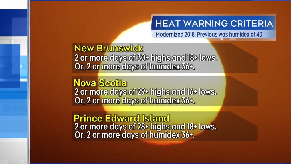 Heat warning criteria for the three Maritime provinces.
Mid-week heat
Parts of the Maritimes are experiencing the first of some unseasonably hot and humid weather Tuesday. High temperatures for much of New Brunswick and interior areas of the southwest of Nova Scotia are expected to reach temperatures in the high 20s and low 30s.
Humidex values, or what it feels like with both heat and humidity, are expected in the mid-to-high 30s.
Both the heat and humidity are expected to reach a peak in the Maritimes Wednesday and Thursday.
On Wednesday, high temperatures reach high 20s and low 30s across most of the region. Humidex values will make it feel in the mid-to-high 30s with some in New Brunswick into the low 40s. There will be cooler coastal areas, especially the Bay of Fundy coastline of New Brunswick and Atlantic coastal Nova Scotia, where the wind is expected to be more onshore.
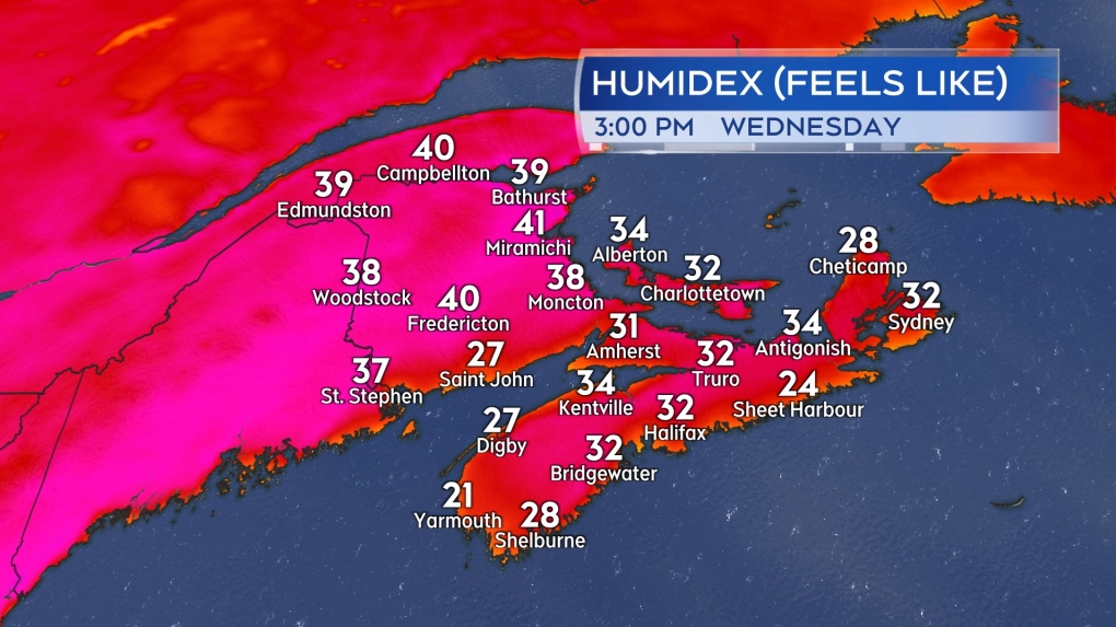 Possible humidex values, or what it feels like with both temperature and humidity, Wednesday afternoon in the Maritimes.
Similar conditions are expected on Thursday with a few exceptions. Once again, areas directly on the coast will have more moderate temperatures as a result of a breeze off the ocean. Additionally, a turn to a northwest wind in northern New Brunswick will start bringing in some slightly cooler and much less humid air. It will still be hot Thursday for northern New Brunswick, but the humidex values could be reduced to the high 20s and low 30s.
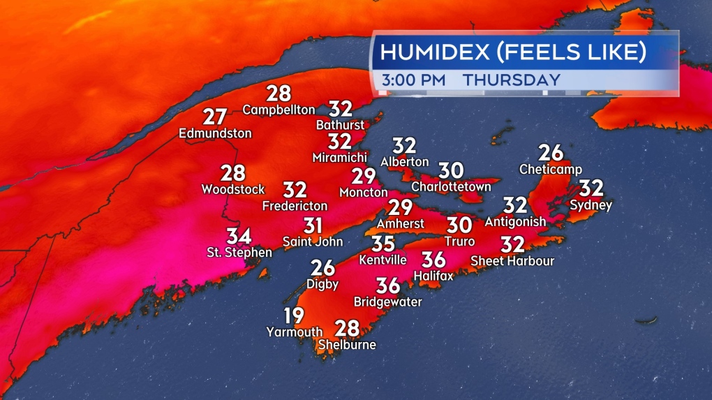 Possible humidex values, or what it feels like with both temperature and humidity, Thursday afternoon in the Maritimes.
Relief Friday into Saturday
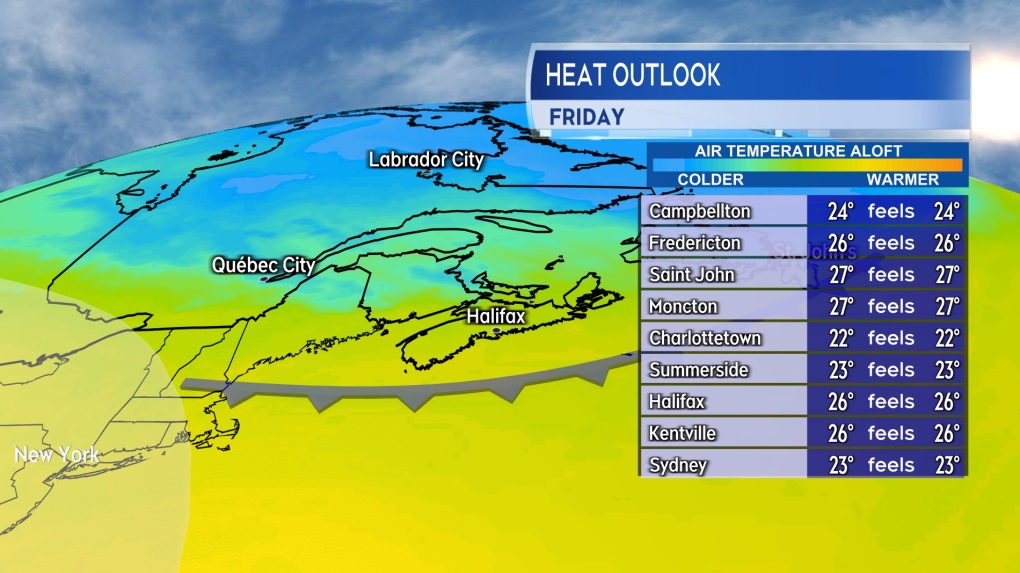
This first round of peak summer heat and humidity doesn’t linger for an overly extended period of time. A cold front is forecast to cross the Maritimes late Thursday into early Friday. Behind the front, some much less humid air filters will arrive from the north and will work to relieve both temperature and humidity levels Friday into Saturday.
Due to the warm, humid air built up ahead of the arrival of the front, as the system moves through, it will bring a risk of thunderstorms. The chance of thunderstorms are highest Thursday afternoon and evening in New Brunswick, Prince Edward Island, and eastern Nova Scotia.
 A cold front brings a risk of thunderstorms to the Maritimes Thursday. Less humid air behind the front will help to relieve the heat and humidity built up for Friday.
Possible first named storm of hurricane season
The National Hurricane Center has designated a developing system in the Gulf of Mexico as Potential Tropical Cyclone One. While not a tropical storm yet there is a high degree of confidence it will develop into one by Wednesday. If and once it does, it will be named Alberto, the first named storm of the 2024 Atlantic hurricane season.
The system is forecast to move westward coming onshore in the Mexican province of Tamaulipas Wednesday into Thursday. The system could bring areas of heavy rain to northeastern Mexico as well as parts of southern Texas. Flash flooding and mudslides in higher terrain are common hazards associated with this type of storm.
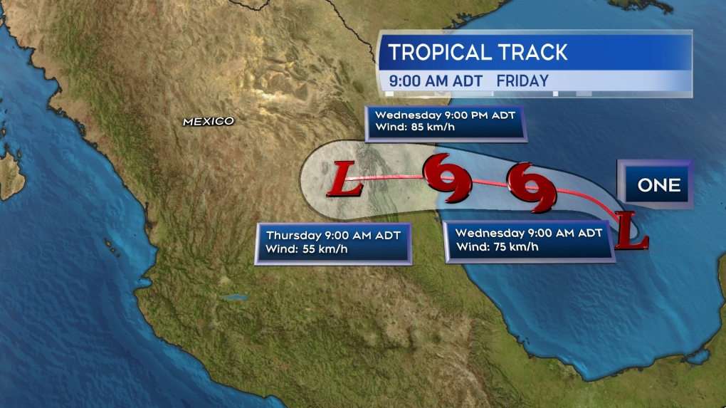 The forecast cone for Potential Tropical Cyclone One issued by the National Hurricane Center.


CTVNews.ca Top Stories

BREAKING
BREAKING Canadian businessman Frank Stronach facing new charges in connection with historical sexual assault investigation
Canadian businessman Frank Stronach is facing eight new charges after police say they've identified additional victims as part of an investigation into historical sexual assault allegations.
House explodes in Transcona, others dealt significant damage: WFPS
The City of Winnipeg is asking people to avoid the area of Camrose Bay after a house exploded.
'Worrying rumours' of planned 'non-consensual sexual acts' at after-prom party prompts Quebec police investigation
Police south of Montreal are investigating, and a school centre has asked parents not to allow their children to attend an after-prom party, after 'worrying rumours that unsavoury events were be planned by certain individuals related to drugs and non-consensual sexual acts.'
Lawyers looking for thousands of families owed money by Veterans Affairs
The suit was launched after the Office of the Veterans Ombud found the government had been improperly calculating the disability benefits and pensions of its clients starting in 2003.
DEVELOPING
DEVELOPING A coup attempt is feared in Bolivia as troops pour into the streets
Bolivian President Luis Arce warned Wednesday that an 'irregular' deployment of troops was taking place in the capital, raising concerns that a potential coup was underway. Presidential Minister Maria Nela Prada called it an 'attempted coup d'etat.'
WestJet to start cancelling flights as early as Thursday as mechanics prepare for possible job action
WestJet says it may start cancelling flights on Thursday as the airline faces a possible strike by its mechanics the day after.
'Why did I have this surgery?' Ont. mother seeks answers after son's tonsil surgery
An Ontario mother said it looked like a horror movie when she flicked on the lights of her son’s bedroom to find him projectile vomiting blood after his tonsils were removed at McMaster Children’s Hospital.
Canada's youngest athlete at the Paris 2024 Olympics could be a 14-year-old skateboarder
Fay De Fazio Ebert, only 14 years old, was one of four athletes named to Canada's Olympic skateboarding group, as Canada Skateboard and the Canadian Olympic Committee revealed their choices on Wednesday.
Are car dealership employees linked to auto thefts in Canada? CTV News investigates
Data from Statistics Canada suggests that a vehicle is stolen every five minutes in the country. Now, police are investigating whether there's a connection between when and where a vehicle was last serviced, and the date it was stolen, they revealed to CTV National News.
Shopping Trends
The Shopping Trends team is independent of the journalists at CTV News. We may earn a commission when you use our links to shop. Read about us.


Toronto
-
BREAKING
BREAKING Canadian businessman Frank Stronach facing new charges in connection with historical sexual assault investigation
Canadian businessman Frank Stronach is facing eight new charges after police say they've identified additional victims as part of an investigation into historical sexual assault allegations.
-
'Disturbing incident': Toronto police identify suspect who allegedly concealed dead body in Riverside apartment
Toronto police say a convicted sex offender wanted on a Canada-wide warrant befriended a 'vulnerable individual' and concealed their dead body in a Riverside apartment last month.
-
'Why did I have this surgery?' Ont. mother seeks answers after son's tonsil surgery
An Ontario mother said it looked like a horror movie when she flicked on the lights of her son’s bedroom to find him projectile vomiting blood after his tonsils were removed at McMaster Children’s Hospital.
Calgary
-

Calgary indoor water-use reductions could ease after July 1 if restoration process goes smoothly
Water services in Calgary could be fully restored by July 1, with some water-use reductions easing shortly after if everything goes according to the city's plan.
-
Charges laid in violent Calgary kidnapping that saw victim restrained, assaulted
Calgary police have laid charges in a horrific and violent kidnapping last month.
-
WestJet to start cancelling flights as early as Thursday as mechanics prepare for possible job action
WestJet says it may start cancelling flights on Thursday as the airline faces a possible strike by its mechanics the day after.
Edmonton
-

Draisaitl: Oilers future will take a 'bit of time'
Leon Draisaitl tried to keep his answers to a minimum when asked about his future with the Edmonton Oilers on Wednesday.
-
Oilers stars McDavid, Draisaitl played through injuries in playoffs: coach
The head coach of the Edmonton Oilers says some of the team's top stars were playing through major injuries during their Stanley Cup playoff run.
-
Police investigating at 82 Avenue apartment building
Police taped off the entrance to an apartment building east of Whyte Avenue early Wednesday morning.
Montreal
-

'Worrying rumours' of planned 'non-consensual sexual acts' at after-prom party prompts Quebec police investigation
Police south of Montreal are investigating, and a school centre has asked parents not to allow their children to attend an after-prom party, after 'worrying rumours that unsavoury events were be planned by certain individuals related to drugs and non-consensual sexual acts.'
-
After teen's death on e-scooter, Montreal councillor reiterates street should be safer
Montreal's Bordeaux-Cartierville city councillor Effie Giannou is calling once again for Lachapelle Street to be made safer after a 14 year-old boy riding an electric scooter was fatally hit by a car on Monday evening.
-
Montreal peregrine falcon chicks take first flights into a world full of danger
This week, three falcon chicks named Hugo, Polo and Estebane started to spread their wings around the nest site on the 23rd floor of the Universite de Montreal tower, with hundreds of online viewers watching their every move.
Ottawa
-

Ottawa Train Yards placed in receivership over owner's unpaid $39 million loan
One of Ottawa's largest shopping centres has been placed in receivership over an outstanding $39 million loan by the owner of the property. The Ontario Superior Court of Justice appointed Grant Thornton Limited as receiver and manager of the assets of Ottawa Train Yards on Industrial Avenue.
-
Man facing charges for allegedly threatening Ottawa Coun. Plante, police say
An Ottawa man is facing charges of uttering threats and harassment after allegedly making threats towards Ottawa-Vanier Coun. Stephanie Plante.
-
Man injured in afternoon Rideau Street assault
Ottawa police are investigating after a man was injured following an assault at the intersection of Rideau Street and King Edward Avenue on Wednesday afternoon.
London
-

Educational charity director charged with fraud
Laura Pethick was hired as the executive director of Foundation for Education Perth Huron in July of 2021. Three years later, she’s accused of defrauding the charity of thousands of dollars.
-
LHSC projects significant deficit this fiscal year
London Health Sciences Centre (LHSC) said they are facing “significant budget pressures” in a statement released on Wednesday. With a deficit of $78.1 million last fiscal year, this year’s projections are estimated to run up to $150 million.
-
Rare weather event brings high winds, toppling trees and hydro wires
Cleanup is underway around the city after a storm blew through the region on Tuesday afternoon. The areas in London hit hardest were north east London and Old North.
Barrie
-
Suspects impersonating police officers make traffic stop in New Tecumseth
Provincial police in New Tecumseth are investigating and warning the public after a report of two men posing as officers who conducted a traffic stop.
-
Hearing held for Barrie police officer facing 2nd misconduct allegation
A high-ranking Barrie Police Service officer facing a second count of discreditable conduct made her first appearance in a virtual Police Services Act hearing Wednesday morning.
-
Severe thunderstorm warning issued for Simcoe County
A severe thunderstorm warning has been issued for parts of Simcoe County as strong winds and heavy rain moves through the region.
Northern Ontario
-

House explodes in Transcona, others dealt significant damage: WFPS
The City of Winnipeg is asking people to avoid the area of Camrose Bay after a house exploded.
-
Sudbury, Ont., Crown takes over criminal prosecution of Ontario’s Ministry of Labour
In court on Wednesday, Sudbury Crown attorney Kara Vakiparta moved to take over what had been the private prosecution of Ontario’s Ministry of Labour on a charge of criminal negligence causing death related to a 2006 mining fatality.
-
One of Canada's most popular vehicles recalled over transmission issue; 95,000 impacted
One of the country's most popular vehicles is being recalled in Canada due to a transmission issue that may impact tens of thousands of drivers.
Kitchener
-

Violent incidents on the rise in Waterloo Region public schools
ETFO is sounding the alarm over an increase in violent incidents at public elementary schools in Waterloo Region.
-
OPP release names in death investigation in Harrow
Essex County OPP have released the names of four family members in an ongoing death investigation in Harrow.
-
Automatic Ontario licence plate renewals start Canada Day
Ontario drivers in good standing won’t have to worry about renewing their licence plates starting Canada Day.
Windsor
-

Weather alerts in effect for region
A severe thunderstorm warning is in effect for Chatham-Kent, Rondeau Park, Western Elgin County, and Eastern Lambton County. Windsor-Essex is under a rainfall warning.
-
E.C. Row Expressway ramp at Dougall Avenue closed after truck rollover
Windsor police have closed the E.C. Row Expressway westbound off ramp at Dougall Avenue.
-
OPP release names in death investigation in Harrow
Essex County OPP have released the names of four family members in an ongoing death investigation in Harrow.
Winnipeg
-
House explodes in Transcona, others dealt significant damage: WFPS
The City of Winnipeg is asking people to avoid the area of Camrose Bay after a house exploded.
-
No charges for driver in 2023 Manitoba bus crash that killed 17 seniors: RCMP
Manitoba RCMP and Crown prosecutors will not lay charges against the driver of a bus involved in a crash with a semi-truck in 2023.
-
Winnipeg woman wins $1M lottery jackpot
A Winnipeg woman is officially a millionaire after winning a Western Max lottery prize.
Regina
-

Walk of Fame inductee Tatiana Maslany celebrated in 'Hometown Stars' event
Award winning actor Tatiana Maslany unveiled her "Hometown Star" in an event in Regina on Wednesday, courtesy of Canada's Walk of Fame.
-
Sask. premier's approval rating similar to last quarter: Angus Reid poll
Despite some recent controversies, Premier Scott Moe’s approval rating remains similar to the last quarter, according to a new Angus Reid poll.
-
Revival for Regina baseball stadium proposal possible
A motion headed before Regina city council could bring the possibility of a new baseball facility in Regina back up to the plate.
Saskatoon
-

Sask. man accused of driving drunk, killing scooter rider released from jail
A man accused of killing a man on an electric scooter while driving drunk has been released from jail.
-
'The federal government can't interfere': Sask. will not comply with federal clean electricity regulations
The Government of Saskatchewan announced that it will not comply with the incoming federal clean electricity regulations.
-
'Scenic route' into Sask. national park closed due to road damage
Drivers looking to take the “scenic route” into the Prince Albert National Park will need to take a detour for now.
Vancouver
-

Child drowns after tube flips over in lake near Cranbrook, B.C.
An 11-year-old boy died after drowning in a lake in southeastern B.C. last weekend, according to authorities.
-
Man charged in Sicamous, B.C., senior's murder
One week after a 66-year-old woman was killed in B.C.'s Shuswap region, a suspect has been charged with second-degree murder.
-
Video of suspect in synagogue arson released by Vancouver police
Vancouver police have released video of a suspect they believe set fire to the entrance of a synagogue last month.
Vancouver Island
-

B.C. coroner says 11 people died of heat injuries in 2023, urges residents to prepare
Eleven people died from suspected heat-related injuries in British Columbia last year, according to the latest data from the provincial coroners service, which is urging residents to prepare for more unusually high temperatures this summer.
-
Meet the centenarians: Canada's oldest age group is also its fastest-growing
Vi Roden said she reads an average of 50 books a year, attends history lectures at her local seniors centre, and does yoga twice a week.
-
Critically endangered Vancouver Island marmots released into the wild
Volunteers carried cages containing very rare furry creatures up Mount Washington on Monday as part of the mission to save Canada’s most endangered mammal.
Kelowna
-

Man stabbed in Kelowna, suspect at large: RCMP
Mounties in Kelowna say a suspect is at large after a man was stabbed in the city Sunday afternoon.
-
Police still investigating cause after woman found dead in Kelowna park
Police are remaining tight-lipped about a woman’s death in a Kelowna park on Friday.
-
Man shot dead in Princeton, B.C., was high-ranking gang member, court records suggest
Police have identified a man found dead in B.C.’s Interior last weekend as Donald “Donnie” Lyons.


