Despite soggy start to the week, Maritimes still mostly below average for June rain
Rain totals reported at several weather station sites across the Maritimes are below 30-year climate averages. There are likely some exceptions to this. Some of our recent weather systems have come with localized downpours and thunderstorms, which have likely brought some communities in the region above the amounts totalled here.
Still, the month is trending better for rain than May did. May finished below half the climate average for rain for a large portion of the Maritimes.
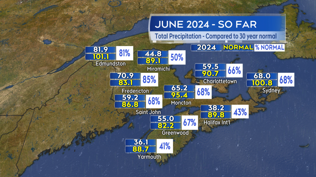 June rain is starting to climb closer to the average for the month. (Source: CTV News Atlantic)
More rain ahead
A few more weather systems over the next several days will give us a shot to get those June rain totals up to average or even a bit higher.
A widespread round of rain and showers is forecast for Thursday as a low-pressure system moves in from northeastern United States. A general rainfall of 10-to-30 mm will come with it but with pockets of 30-to-50 mm possible as a result of embedded downpours and thunderstorms.
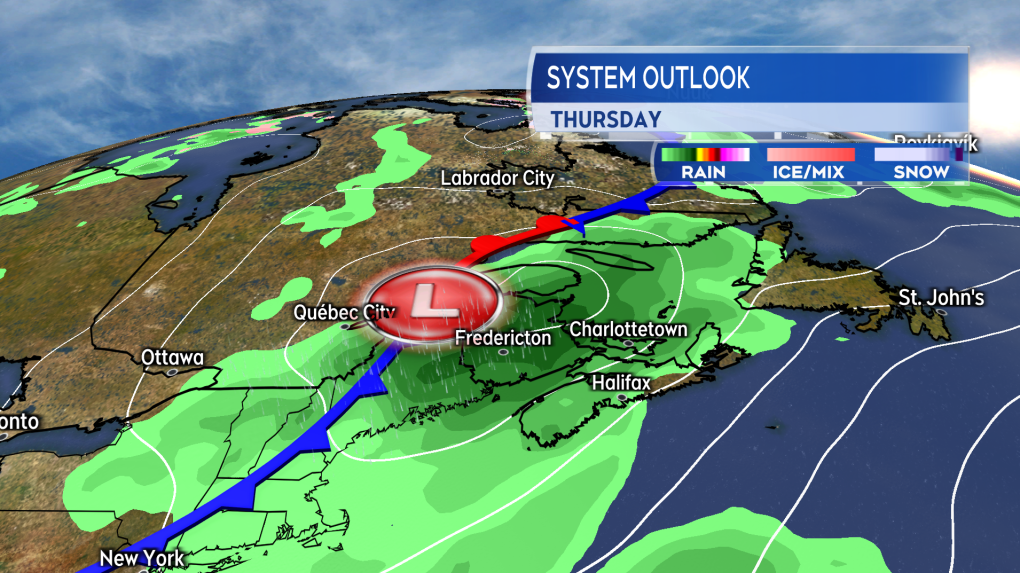 Rain and showers moving across the Maritimes on Thursday. (Source: CTV News Atlantic)
Following that, a low-pressure system moving through Ontario and into Quebec brings a weather front into the Maritimes Saturday into Sunday. Showers will develop in New Brunswick on Saturday before rain and showers become more widespread across the Maritimes on Sunday.
Between those two weather systems, it is certainly possible to get enough rain to close the remaining gap between how much June rain we’ve had so far and the averages for the month.
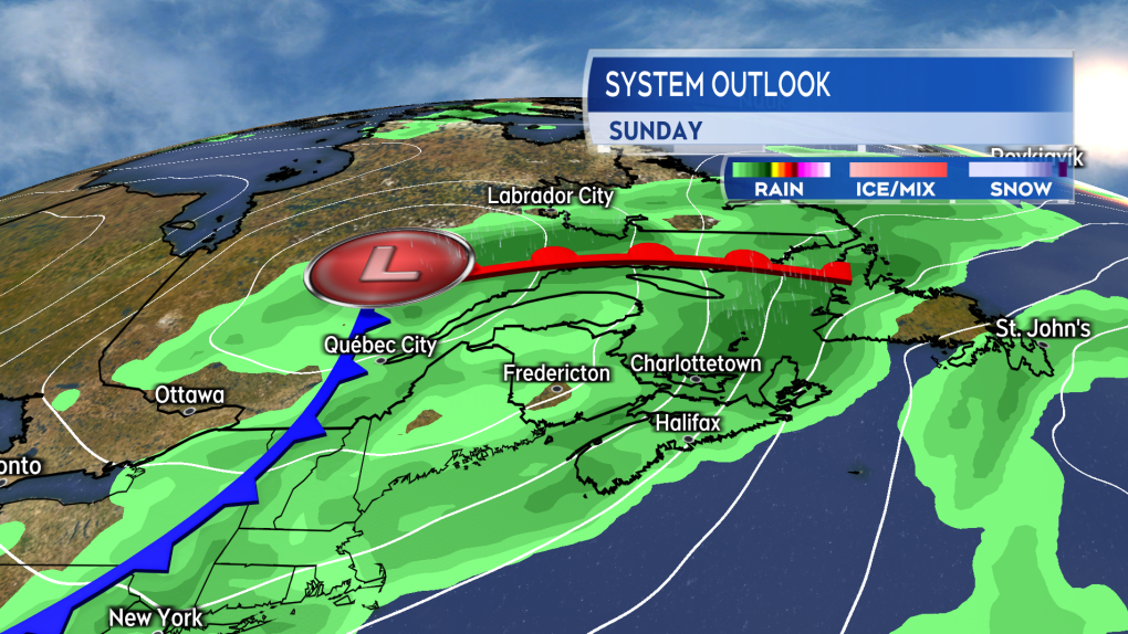 A slower moving weather front returns wet weather across the region Sunday. The system may also impact Canada Day weather in the Maritimes. (Source: CTV News Atlantic)
Early Canada Day outlook
As it stands, I’d have to go with a chance of showers for New Brunswick and Prince Edward Island for Canada Day. Rain or showers are possible for Nova Scotia.
The reason for that is the projected slow speed of the weather front coming through on Sunday. While the front enters New Brunswick on Sunday, it may slow and stall near the Atlantic coastline of Nova Scotia by Monday. That province being closest to the front keeps the possibility of some areas of rain in the forecast.
This far out in the forecast, it wouldn’t be unusual to see the timing of the front chance by 12-to-24 hours. A quicker pass by the Maritimes of that front would improve the Canada Day outlook.


CTVNews.ca Top Stories

Debate takeaways: Trump confident, even when wrong, Biden halting, even with facts on his side
Thursday’s U.S. presidential debate was a re-run that featured two candidates with a combined age of 159, but it went especially poorly for one of them, President Joe Biden.
NEW
NEW Car thieves tried accessing Ontario transportation ministry database
One of Canada's largest police forces has knowledge of car thieves attempting to breach Ontario's Ministry of Transportation database, CTV News has learned.
What is going on with immigration in Canada? Here's what the data shows
Canada has welcomed more than 3.9 million new citizens since 2005, with nearly one third coming from India, the Philippines or China, according to a CTVNews.ca analysis.
Economy grew 0.3% in April, Statistics Canada reports
Statistics Canada says real gross domestic product grew 0.3 per cent in April, helped by strength in several industries including wholesale trade, mining and oil and gas extraction and manufacturing.
Liberal caucus staying quiet after major byelection defeat that rattled party
Liberal campaign co-chair Terry Duguid insisted Thursday that his caucus is united behind Prime Minister Justin Trudeau, even as the majority of elected Liberals remain silent on the prime minister's political future.
Buying a car? Why you may have to pay more at some dealers if you use cash
It used to be cash was king and that you could get a better deal if you paid for a car in full, but now many dealers want you to finance your purchase so they can make more money.
Princess Anne leaves hospital after treatment for concussion
Princess Anne has left the hospital and returned to her southwestern England estate after an accident thought to involve a horse left her with a concussion.
FACT FOCUS: Here's a look at some of the false claims made during Biden and Trump's first debate
President Joe Biden and former President Donald Trump traded barbs and a variety of false and misleading information as they faced off in their first debate of the 2024 election.
Analysis of the CNN Presidential Debate between Joe Biden and Donald Trump
U.S. President Joe Biden and former president Donald Trump went head-to-head in the first of two planned presidential debates.
Shopping Trends
The Shopping Trends team is independent of the journalists at CTV News. We may earn a commission when you use our links to shop. Read about us.


Toronto
-

Buying a car? Why you may have to pay more at some dealers if you use cash
It used to be cash was king and that you could get a better deal if you paid for a car in full, but now many dealers want you to finance your purchase so they can make more money.
-
What's open and closed? Where are the fireworks? What to know for Canada Day 2024
The Canada Day long weekend is just around the corner. Here’s everything you need to know to plan your long weekend:
-
Canada Day weather forecast in Toronto
Canada Day in Toronto will be filled with sunshine and a high of 24 C before the summer humidity makes a comeback late next week.
Calgary
-

Calgary's 16 Avenue reopens as water main prepares for flushing
As the City of Calgary inches closer to fixing the water main issues prompting water restrictions, 16 Avenue N.W. is starting to reopen.
-
Why aren't free-ranging bison classified as wildlife in Alberta?
Several wildlife and Indigenous groups are renewing calls for the provincial government to designate all free-ranging bison as wildlife under the Alberta Wildlife Act, as opposed to livestock.
-
UCP blasts new NDP leader Nenshi with attack ads; Smith says he has no policy
The UCP has come out swinging at new Alberta NDP leader Naheed Nenshi in a series of attack ads.
Edmonton
-

3-year-old boy dead, woman and girl hospitalized in Allard crash
A boy was killed and his mother and sister were injured in a crash in south Edmonton on Thursday.
-
Holland leaves Oilers; CEO searching for new GM before starting negotiations with Draisaitl
Ken Holland is out as Edmonton Oilers president of hockey operations and general manager. He joined the Oilers in May 2019 and his contract ends this Sunday.
-
Jagmeet Singh makes his case to Alberta's new NDP leader amid party separation talks
Breaking up the federal and provincial arms of the New Democratic Party would be a mistake, federal NDP Leader Jagmeet Singh suggested on Thursday, as members in Alberta increasingly vocalize their desire for a separation.
Montreal
-

Woman killed after tree falls on her in Mont-Saint-Bruno park
The pond sector at the Mont-Saint-Bruno Provincial Park is closed after a woman died after a tree fell on her on the Grand-Duc trail on Thursday.
-
Here is the schedule for the International fireworks competition in Montreal
The Loto Quebec International Fireworks competition begins Thursday in Montreal with a tribute to boy and girl bands.
-
Weekend strike for Sorel-Saint-Ignace-de-Loyola ferry
Another strike is expected to affect the ferry linking Sorel to Saint-Ignace-de-Loyola this weekend.
Ottawa
-
 NEW THIS MORNING
NEW THIS MORNING Ottawa Public Health warning of increased overdose risk as new drug found in local supply
Ottawa Public Health is issuing a warning about a new drug found in the local unregulated drug supply that could lead to a spike in overdoses.
-
NEW THIS MORNING
NEW THIS MORNING What's happening in Ottawa this weekend: June 28-July 1
CTV News Ottawa looks at things to do in Ottawa during the Canada Day long weekend.
-
Ottawa police warn residents to avoid Facebook Marketplace when looking for a place to rent
Ottawa police are going as far as to tell people to stay away from Facebook Marketplace altogether when looking for a place to rent because of the prevalence of scams.
London
-

Charges laid in fatal hit and run in St. Thomas
Charges have been laid in relation to a recent fatal fail to remain investigation in St. Thomas. The accused appeared in court Thursday and has been remanded into custody.
-
Outreach workers express concern about council’s decision to expand restrictions on homeless encampment locations
On the frontlines of London, Ont.’s homelessness crisis, council’s recent decision to further restrict the places where encampments are permitted is causing concern and confusion.
-
Residents express frustration with decision to close Huron County pool
For nearly 50 years, Clinton's kids have enjoyed an outdoor pool. However, following a three-year long closure due to expensive required repairs, Clinton's pool will now never be swam in again.
Barrie
-

Midland in mourning after loss of long-time councillor Jim Downer
The Town of Midland is in mourning after the sudden loss of a local political titan who spent decades working in public service.
-
Ramara man admits to stabbing mother 30x after eating cannabis brownies
Michael Lahay pleaded guilty to manslaughter for stabbing his mother, Wendy, 30 times inside their Ramara home in 2021 while experiencing "substance-induced psychosis" after he ate a dozen homemade cannabis brownies.
-
Ready for summer? Two Barrie beaches open with lifeguards today
The city urges water safety on all of Barrie's beaches.
Northern Ontario
-

LCBO to close all retail stores for 14 days if strike not averted
With a week left until thousands of LCBO workers could walk off the job, the Crown corporation has announced that it will close all its retail stores for 14 days if no deal is reached by July 5.
-
Northwestern Ont. police investigate fatal Hwy. 17 crash
The Dryden detachment of the Ontario Provincial Police is investigating a fatal collision involving a commercial vehicle and a passenger vehicle.
-
Buying a car? Why you may have to pay more at some dealers if you use cash
It used to be cash was king and that you could get a better deal if you paid for a car in full, but now many dealers want you to finance your purchase so they can make more money.
Kitchener
-

Guilty plea to second-degree murder of Kitchener man
A man, previously found guilty of first-degree murder in connection to a 2014 death in Kitchener, has pleaded guilty to a lesser charge.
-
Showdown expected at Thursday night's Stratford council meeting
Drama is usually reserved for the Stratford Festival stage, but on Thursday night, it might play out at Stratford City Hall - again.
-
Extended care registration will reopen in July for Waterloo Region schools
Parents who ran into technical problems with Waterloo Region’s registration system for before and after school programs have a new date to circle on their calendars.
Windsor
-

Funeral arrangements released for Walsh family found dead in Harrow
The funeral arrangements for a family found dead in a home in Harrow have been released.
-
Footwear used as a weapon in Chatham-Kent: Police
Charges have been laid in Chatham after a person used a boot as a weapon, according to police. Around 9:30 p.m. on Thursday, police were called to a disturbance on Erie Street south in Merlin.
-
VIA unveils new, accessible trains, but civic leaders call for more service
VIA Rail unveiled the first cars in its new fleet of state of the art passenger trains Thursday, with leaders taking part in the inaugural ride between London and Windsor.
Winnipeg
-

'I felt my soul was broken': Women sexually assaulted by Manitoba doctor call for accountability
A sentencing hearing is underway for a Manitoba doctor found guilty of sexually assaulting multiple patients over several years.
-
'Houses don't just explode': Winnipeg police give update on Transcona blast
Winnipeg police say the occupants of a home that exploded in the Transcona neighbourhood on Wednesday were not there at the time of the blast.
-
'I am very proud': Manitoba grandfather and grandson graduate high school in same class
A grandfather and grandson duo proudly graduated alongside each other at the same northern Manitoba school.
Regina
-

'The line has already been crossed': Day 4 of Dumba trial sees vastly different accounts from accused, victim
Thursday marked day four of the trial of Jeffrey Dumba, a former Regina teacher who is accused of sexually exploiting a 15-year-old female student.
-
Federated Co-operatives Limited reports cybersecurity incident, investigation underway
Federated Co-operatives Limited (FCL) is investigating after suffering what it calls a "cybersecurity incident."
-
July is the worst month for impaired driving deaths in Saskatchewan, SGI says
SGI wants to help make roads safer this month with its traffic safety spotlight on impaired driving.
Saskatoon
-

Canada's top court rejects appeal from Sask. man who murdered wife
The Supreme Court of Canada has rejected an application from a Saskatoon man who murdered his wife.
-
'Hanging on for her life': Sask. family desperate to bring home sick niece from Philippines
For half a decade, a Saskatoon family has been trying to bring their orphaned niece to Canada, they say now it’s a matter of life or death.
-
Road Hogs: Saskatoon truck spills load of pig parts in rush hour traffic
Drivers in Saskatoon’s north industrial area were treated to a grisly sight on their commute home on Thursday — a truck apparently spilled a load of pig parts onto Millar Avenue.
Vancouver
-

Waves Coffee chain fined nearly $31K for lack of recycling plan
A Metro-Vancouver-based coffee chain has been fined thousands of dollars for failing to present and follow a recycling plan.
-
Stadium agreement with FIFA reveals obligations for hosting World Cup at BC Place
In 2026, the eyes of the world will be on BC Place as it hosts seven matches in the FIFA World Cup, but until recently, nobody has been able to lay eyes on the stadium agreement for those games.
-
Police tight-lipped about West Vancouver crash that killed 2, injured 3; some victims still not identified
West Vancouver police aren't revealing many details about a two-vehicle crash on Highway 1 just before midnight Wednesday night that left two people dead and sent three others to hospital.
Vancouver Island
-

World's largest hockey stick in B.C. to be chopped up, sold to collectors
The world's largest hockey stick could soon become the world's most in-pieces hockey stick as a Vancouver Island community prepares to tear down and carve up the Canadian landmark.
-
Man accused in Victoria double-stabbing now charged with murder, police say
Months after a double-stabbing in downtown Victoria that left one victim dead, a suspect has been charged with murder.
-
Busy long weekend ahead for BC Ferries, airports, hotels
The hospitality and tourism industry in B.C. is looking forward to a busy Canada Day long weekend.
Kelowna
-

Man stabbed in Kelowna, suspect at large: RCMP
Mounties in Kelowna say a suspect is at large after a man was stabbed in the city Sunday afternoon.
-
Police still investigating cause after woman found dead in Kelowna park
Police are remaining tight-lipped about a woman’s death in a Kelowna park on Friday.
-
Man shot dead in Princeton, B.C., was high-ranking gang member, court records suggest
Police have identified a man found dead in B.C.’s Interior last weekend as Donald “Donnie” Lyons.


