Shelf clouds spotted in Cape Breton Tuesday; May heat continues
 A shelf cloud spotted near Sydney, N.S. (Courtesy: Stan Peach)
I always love getting pictures sent in of unique cloud formations! A number from Cape Breton on Tuesday featured shelf clouds, which are a type of arcus cloud. This type of cloud is characterized by a smooth, arced line at the base of what is usually a convective cloud. A convective cloud is the type to produce pop-up showers or thunderstorms. The shelf cloud doesn’t necessarily need to come along with falling rain or an active thunderstorms though.
The shelf cloud in Cape Breton Tuesday didn’t come with much rain or a thunderstorm. It may have been associated with what was left of a small thunderstorm that passed across P.E.I. hours earlier.
A shelf cloud spotted near Sydney, N.S. (Courtesy: Stan Peach)
Heating up
Wednesday will once again feature unseasonably warm temperatures across the Maritimes. High temperatures away from the coast will soar into the mid-to-high twenties for a large part of the Maritimes. A modest level of humidity in the air will produce humidex values making it feel near or into the low-thirties for those areas. An active sea breeze — a wind onshore off cooler ocean water — will keep exposed coastal areas with high temperatures mostly ranging 15-to-20 C.
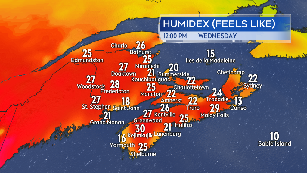 Unseasonably warm and humid weather for the month of May. (Source: CTV News Atlantic)
Conditions in the Maritimes will remain warm and slightly humid through Friday. Less humid air is expected to filter into the region by Saturday. High temperatures are set to cool back towards monthly averages on the weekend.
Showers, risk of thunderstorms
Warm, humid weather provides energy for pop-up showers and thunderstorms. A few spotty showers or small thunderstorms could develop in southern New Brunswick and the interior of Nova Scotia Wednesday afternoon into early evening. Edmundston and the northwest of New Brunswick, Moncton and the southeast, as well as northern areas of mainland Nova Scotia, will have a chance of showers or thunderstorms developing overnight. These showers or thunderstorms will be widely scattered and very hit-and-miss by nature.
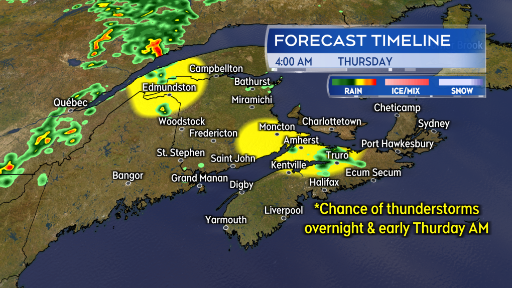 Showers with a risk of thunderstorms overnight for a few spots of the Maritimes. (Source: CTV News Atlantic)
A weather front arriving into New Brunswick during the day on Thursday will produce periods of rain. One round will come across the province Thursday morning into early afternoon. A second round will develop late afternoon into evening. There will be a chance of showers Thursday morning for Prince Edward Island followed by scattered showers in the afternoon. Scattered showers are expected in eastern areas of Nova Scotia. Once again the rain and showers will be accompanied by a risk of thunderstorms.
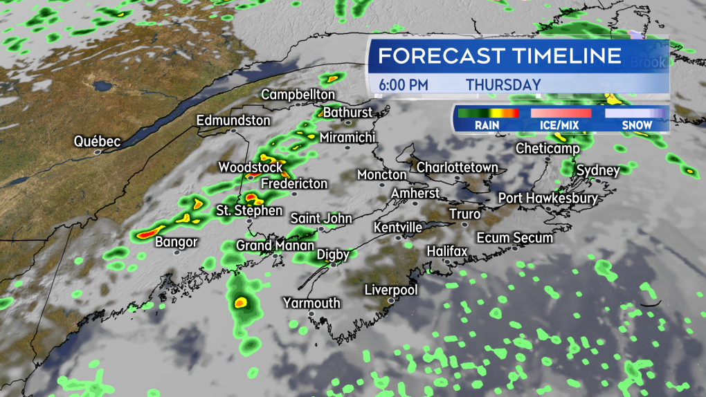 Periods of rain with a risk of thunderstorms for New Brunswick Thursday. A chance of showers for both Nova Scotia and Prince Edward Island through the day. (Source: CTV News Atlantic)
Along with lightning, the thunderstorm could produce some localized rain totals of 20-to-40 mm. That is most likely in New Brunswick.
When thunder roars, head indoors. Wait 30 minutes after the last rumble of thunder before heading back out.
Updates on any active showers and thunderstorms, along with forecast timelines, are shared nightly on CTV News Atlantic at 5, 6, and 11:30 p.m.


CTVNews.ca Top Stories

NEW
NEW From lifestyle changes to climate change, why some Canadians are delaying having children
Some Canadians feel stuck between a rock and a hard place when considering starting a family, while others are concerned about what their child's future could look like.
Don Valley Parkway reopens after record-breaking rainfall, flooding in Toronto
The Don Valley Parkway and Gardiner Expressway have reopened this morning following record-breaking rainfall in Toronto on Tuesday that caused widespread flooding.
opinion
opinion How to turn your hobbies into income during retirement
In his financial advice column for CTVNews.ca, Christopher Liew outlines some simple steps retirees can take to use their pastimes to earn money.
The guidance for RSV vaccines has changed. Here's what Canadian seniors need to know
Health officials recently changed the guidelines for respiratory syncytial virus vaccines. Here's what Canadians need to know about the guidance and the virus itself.
Amazon Prime Day is a big event for scammers, experts warn
Amazon Prime Day is here, and experts are reminding consumers to be wary of scams. Here's what you need to know.
Traces of cyanide are found in the blood of Vietnamese and Americans found dead in a Bangkok hotel
Initial autopsy results showed traces of cyanide in the blood of six Vietnamese and American guests at a central Bangkok luxury hotel and one of them is believed to have poisoned the others over a bad investment, Thai authorities said Wednesday.
What is leading to low attendance at one of the country's most popular football stadiums?
The Saskatchewan Roughriders have one of the strongest fan bases in the league but are having a tough time filling their stadium this year.
Husband sentenced to 16 years for killing B.C. teacher-librarian
The B.C. man who pleaded guilty in the death of his wife – Langley teacher-librarian Naomi Onotera – has been sentenced to 16 years in prison.
Toronto flooding: Pictures, videos show heavy rainfall in downtown core
Toronto was pounded by torrential rain Tuesday afternoon and pictures and video are showing the extent of the flooding in the city’s downtown core and beyond.
Shopping Trends
The Shopping Trends team is independent of the journalists at CTV News. We may earn a commission when you use our links to shop. Read about us.


Toronto
-

Don Valley Parkway reopens after record-breaking rainfall, flooding in Toronto
The Don Valley Parkway and Gardiner Expressway have reopened this morning following record-breaking rainfall in Toronto on Tuesday that caused widespread flooding.
-
What to know about insurance claims after Tuesday's flash flooding
As people in southern Ontario survey the damage done by intense flash flooding on Tuesday, the Insurance Bureau of Canada says residents need to figure out what their policies cover.
-
Half of Ontarians support union’s goals in ongoing LCBO strike: poll
Fewer than one-third of Ontarians say they want the provincial government to intervene to end the 12-day strike at Ontario’s main liquor retailer, while about half are supportive of the striking union’s demands.
Calgary
-

50 water rescues in 2 weeks have Calgary first responders urging caution
It's only two weeks into July, but Calgary's first responders are putting out another safety warning after responding to roughly 50 water rescues this month alone.
-
Black bear euthanized after killing small dog in Canmore
A black bear was euthanized after killing a dog in Canmore, Alta., over the weekend.
-
Air conditioner use on the rise over the past decade, according to Statistics Canada
With another heat warning in much of Alberta, it’s a hot market for air conditioners.
Edmonton
-

"A sleeper problem": Ontario research team studies hailstorms in Olds, Alta.
Researchers from Ontario are spending their summer in Olds, Alta., to take a closer look at the province's hail systems.
-
Heat could hang over Alberta for 10 days, bringing highs up to 36 C
A heat warning has been issued for large parts of Alberta, where Environment Canada is warning daytime highs up to 36 C could linger for the next eight to 10 days.
-
Pickleball players robbed at gunpoint south of Edmonton: RCMP
Three people were robbed at gunpoint after a pickleball game in Millet, Alta., on Monday.
Montreal
-

Quebec business owner says city not granting signage permit over concerns about English word
The owner of a Quebec-based party supply store is criticizing the City of Brossard for not issuing a signage permit due to concerns about the English word "party."
-
Old Montreal restaurant owner victim of break-in, worries about his neighbourhood
Youssef Shanab spent much of his Monday night at his restaurant in Old Montreal even though it wasn't even open.
-
A giant lizard has gone missing in Sherbrooke
Julie Blanchard, a resident of Sherbrooke, is asking the public to keep an eye out for her one-year-old domesticated tegu giant lizard, which went missing on Saturday.
Ottawa
-

One person dead after Orléans shooting
Ottawa Police say one person is dead after a shooting Tuesday night on Trigoria Cres.
-
NEW THIS MORNING
NEW THIS MORNING Ottawa police officers getting more photo radar tickets: report
A report prepared for the Ottawa Police Service Board shows driving-related complaints against Ottawa police officers are on the rise, with staff blaming the expansion of automated speed enforcement cameras in the city.
-
'I was baffled': Road rage victim frustrated by Ottawa police response
An Ottawa man is speaking out after he was slammed to the ground, choked, and kicked in the middle of the street in Manotick.
London
-

Fatal crash being investigated in Huron County
Around 4:20 p.m. on Tuesday, emergency services responded to a crash between a pickup truck and a semi-truck in the area of Perth Road 164 and Sunshine Line in South Huron — about 20 km southeast of Exeter.
-
OPP recover body from waters off Port Stanley beach
OPP have confirmed to CTV News that a body has been pulled from Lake Erie as of 2:55 p.m.
-
Flooded streets and basements as more heavy rain causes grief, severe thunderstorm watch in effect
Heavy rain walloped parts of the region again Tuesday, just as many were cleaning up from Monday’s downpour.
Barrie
-

Homicide under investigation in Midland
Police in Midland are investigating a homicide following a call for service on Monday afternoon.
-
Trent-Severn Waterway adjusting dam due to heavy rainfall
Heavy rainfall has forced Trent-Severn Waterway management to adjust dam.
-
Barrie's busking program seeks brave artists
Permits are available for buskers to perform in downtown Barrie.
Northern Ontario
-

Timmins suspects recorded unprovoked assault on their cellphones, police say
The Timmins Police Service and Crime Stoppers are asking for the public’s help in finding two suspects responsible for an unprovoked assault early Monday morning.
-
Massive sinkhole caused by intense rain in northeastern Ontario
Cleanup is continuing after a storm bringing intense rain to parts of northeastern Ontario passed through the region on Monday washing out roads and creating sinkholes.
-
Sudbury doctor says screen-free classrooms would benefit students
When Dr. Emily Dubé’s daughter started school in the city, Dubé was shocked by the amount of screen time used in the classroom.
Kitchener
-

Second body recovered from Grand River after women seen struggling on the water
The search for two women who ran into trouble while out on the Grand River in Kitchener, Ont. has ended as a second body has been recovered.
-
Standoff ends after barricaded man surrenders in Kitchener
A police standoff in South Kitchener is over and one person is in custody after what neighbours described as a dramatic scene on Tuesday afternoon.
-
Heavy rainfall floods roads, trails and parks in Waterloo Region
The heavy downpour on Tuesday morning caused some severe – but temporary – flooding across Waterloo Region and beyond.
Windsor
-

Abduction, torture of 3 people leads to 12 suspects charged: Windsor police
Windsor police have charged 12 suspects in connection with the abduction and torture of three people and investigators believe there may be more victims.
-
Overnight storm rips through area of Remington Park
Eddie Beaune watched a tree fall to the ground during Monday night's storm at 3 a.m. “My dog was barking his head off. He wouldn't eat,” Beaune said. “I thought maybe he usually wakes me up when he has to go to the bathroom so I open the door and he wouldn't even leave the porch.”
-
Local Chambers of Commerce urge people to stop buying so much from Amazon
As Amazon Prime Day deals fill up online shopping carts, the Chatham-Kent Chamber of Commerce has issued an anti-Prime Day message, encouraging you to shop local instead.
Winnipeg
-

'No eviction notices, nothing': Tenants of Winnipeg apartment left homeless after rooms cleared out
Residents at a College Avenue apartment could be left homeless after being evicted earlier this week.
-
'Not in this area': Linden Woods residents concerned about drug treatment centre in the area
Homeowners in Linden Woods are pushing back against a drug treatment centre in a home in the area.
-
Have you seen this painting? Woman looking for lost artwork
An art student who was ordered to vacate her McDermot Avenue home says an important painting has gone missing.
Regina
-

'I was so excited': Two boys act as Commanding Officers of RCMP Depot for a day
Thanks to a joint effort between the Saskatchewan RCMP, the Alberta RCMP, and the Kids with Cancer Society, two boys were able to act as Commanding Officers of RCMP Depot in Regina for a day.
-
'We don’t install windows and doors': Contractors with similar name to fraudsters speak out
Two Regina-area contractors are speaking out on the impact a recent fraud case has had on their business.
-
'Forever grateful': Thomson family thanks loyal fans and supporters of 'Bella Brave'
The family of Isabella Thomson took to social media to thank those who have supported them following the death of the social media starlet and advocate, known as “Bella Brave.”
Saskatoon
-

Cousins who beat up a 45-year-old man on Sask. farm sentenced
Two cousins who beat and tied up a 45-year-old man on a farm near Melfort in 2022 were given a two-year sentence on Monday, which will be served in the community.
-
Sask. government hires operator for Saskatoon's 'complex needs' shelter
The province has chosen a group to operate Saskatoon’s complex needs shelter as it inches towards opening.
-
Humboldt Broncos welcome home Brayden Klimosko as new head coach, GM
The Humboldt Broncos have announced Brayden Klimosko is taking over the reigns of his hometown hockey team, effective immediately.
Vancouver
-

'I feel like he did not die in vain': Family responds to report on tortured B.C. boy's death
The heartbreak over the death of an Indigenous 11-year-old Fraser Valley boy, tortured and then ultimately killed by his foster parents, was felt by all who knew him.
-
As wildfires spark, B.C. prepares for other emergency situations as well
With the public's eyes on the soaring wildfire risk, British Columbia's emergency officials continue to monitor and prepare for other emergencies as well, staying in close contact with local governments.
-
'Just so grateful': B.C. man uses Google Lens to reunite woman with lost family heirloom
After more than three years, a B.C. woman has been reunited with a lost family heirloom.
Vancouver Island
-
'I feel like he did not die in vain': Family responds to report on tortured B.C. boy's death
The heartbreak over the death of an Indigenous 11-year-old Fraser Valley boy, tortured and then ultimately killed by his foster parents, was felt by all who knew him.
-
As wildfires spark, B.C. prepares for other emergency situations as well
With the public's eyes on the soaring wildfire risk, British Columbia's emergency officials continue to monitor and prepare for other emergencies as well, staying in close contact with local governments.
-
B.C. youth representative says official inaction led to boy's torturous death in foster care
British Columbia's representative for children and youth is calling for a complete overhaul of the province's foster care model following the torture and death of an 11-year-old boy in 2021.
Kelowna
-

Motorcyclist seriously injured in Kelowna crash: RCMP
A motorcyclist was severely injured in a crash with an SUV Sunday afternoon, according to the Kelowna RCMP.
-
Crews searching for Alta. man swept away by river in B.C.
A search effort is underway for a man who was swept away by the North Thompson River in Kamloops on Friday.
-
1 dead, 17 displaced after Kelowna apartment fire
One person is dead and 17 others have been displaced after a stubborn fire burned overnight in a Kelowna apartment building.


