Spring snow brings possible slippery start to parts of the Maritimes Thursday
 A beautiful first sunrise of spring at Florence, N.S., on March 20, 2024. (Courtesy: Judith Brennan)
With the equinox having occurred at 12:06 AM, Wednesday, we are now into the start of astronomical spring. Spring snow isn’t uncommon for the Maritimes, as we have some in the forecast.
Spring mix
A low-pressure system moving out of the northeastern U.S. Wednesday will cross New Brunswick on Thursday. The weather system is bringing the Maritimes a mix snow, flurries, and showers through that time.
Showers and flurries first arrive in western New Brunswick and southwestern Nova Scotia Wednesday afternoon. The mix becomes more widespread for the region Wednesday evening and night.
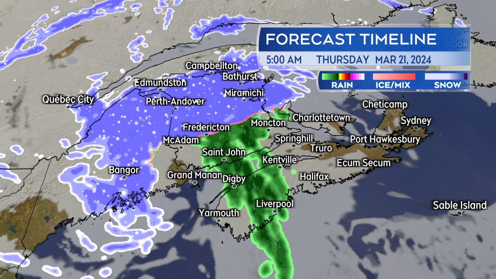 A mix of showers and flurries moves across the Maritimes Wednesday night into Thursday morning. A period of snow possible Thursday morning for parts of central and northern New Brunswick. (Source: CTV News Atlantic)
Snowy start for parts of New Brunswick
The mixture of flurries and showers may intensify into accumulating snow for central and northern areas of New Brunswick early Thursday morning. With temperatures near freezing, some accumulation of one to five centimetres may occur for Fredericton and north in the province to get Thursday started. While not a tremendous amount, it may be enough to create some slippery spots for the Thursday morning drive.
Further snow and flurries throughout the day on Thursday may total additional snow in the hilly and mountainous areas of northern New Brunswick. Some snow totals for that higher terrain could reach five-to-15 cm by the end of the day. Gusty winds will accompany the falling snow and could blow it around enough to reduce visibility for brief periods of time.
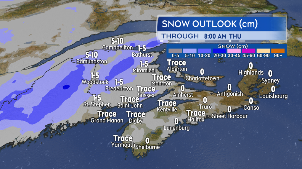 With temperatures hovering near freezing and snow falling early Thursday morning watch for possible slick spots in central and northern areas of New Brunswick to start Thursday. (Source: CTV News Atlantic)
Windy Thursday
As above, gusty winds are expected to accompany the passage of the low-pressure system on Thursday. Peak wind gusts could reach 50-to-80 km/h on Thursday. The highest gusts are most likely at higher terrain and exposed areas of the coast. For most of the Maritimes the wind will be out of the west and southwest during the day on Thursday and then changing to west and northwest Thursday night.
Due to the topography of the Cape Breton Highlands, the wind gusts will be stronger in Inverness County from Margaree Harbour to Bay St. Lawrence. The area is under a wind warning by Environment Canada. Gusts up to or in excess of 100 km/h are expected Thursday morning through Thursday afternoon.
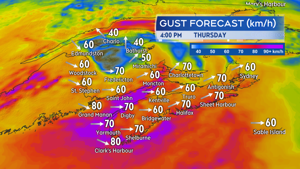 The passing low-pressure system brings a windy day on Thursday. Gusts could peak as high as 50 to 80 km/h and even stronger in northern Inverness County, Cape Breton. (Source: CTV News Atlantic)
Atlantic Top Stories
-
-
 DEVELOPING
DEVELOPING Live updates: Category 4 Hurricane Milton approaches Florida coast
-
-
-
-
-
-


CTVNews.ca Top Stories
DEVELOPING
DEVELOPING Live updates: Category 4 Hurricane Milton approaches Florida coast
Hurricane Milton is a Category 4 storm forecast to bring extreme flooding, high winds and heavy rain to the central west coast of Florida.
BREAKING
BREAKING Increased risk of crash prompts recall of 239K vehicles in Canada
Hundreds of thousands of vehicles are being recalled in Canada due to a steering-related issue that could increase a driver's risk of crash.
COVID-19 may increase the risk of heart attacks, strokes and deaths for three years after an infection, study suggests
COVID-19 could be a powerful risk factor for heart attacks and strokes for as long as three years after an infection, a large new study suggests.
New actions announced to encourage building of secondary suites, more homes in Canada
The federal government introduced a number of measures related to housing on Tuesday, which include measures for homeowners wanting to add a secondary suite, taxing vacant land and building homes in place of underused federal properties.
'A cause for concern': Canadian universities slip down world ranking list
An organization that ranks the best universities across the globe says its latest report shows a concerning trend that several of Canada’s institutions are slipping down its list.
What women should know about their breasts, according to a doctor
One in eight women will be diagnosed with invasive breast cancer in their lifetimes, according to the American Cancer Society. Breast cancer is the second leading cause of cancer death for women in the United States, with 42,000 women dying every year from this cancer.
Time to evacuate is running out as Hurricane Milton closes in on Florida
Hurricane Milton churned Wednesday toward a potentially catastrophic collision along the west coast of Florida, where some residents insisted they would stay after millions were ordered to evacuate and officials warned that stragglers would face grim odds of surviving.
Andrew Garfield shares the gift he's discovered in grieving his mother
Andrew Garfield’s ability to so lovingly and poetically express his grief for his mother, Linda, who died of pancreatic cancer in 2019, offers a gift of connection, and, perhaps, catharsis, to anyone experiencing loss.
Worried about porch pirates? Amazon now offers in-garage delivery across Canada
Amazon has just launched a new service in Canada where delivery drivers can drop packages off directly in garages for those who want to protect their parcels from being swiped by porch pirates.
Shopping Trends
The Shopping Trends team is independent of the journalists at CTV News. We may earn a commission when you use our links to shop. Read about us.


Toronto
-

Worried about porch pirates? Amazon now offers in-garage delivery across Canada
Amazon has just launched a new service in Canada where delivery drivers can drop packages off directly in garages for those who want to protect their parcels from being swiped by porch pirates.
-
Another beluga dies at Marineland, Ontario saying little on 4-year probe into park
Another beluga whale has died at Marineland and four years into a provincial probe, Ontario's solicitor general is saying little about the investigation's progress.
-
Four injured after car, 2 TTC buses collide: Toronto paramedics
Four people have been transported to hospital following a collision near Toronto’s Forest Hill neighbourhood early Wednesday morning, paramedics say.
Calgary
-

1 charged after several stolen cars found at Calgary auto dealership
An Airdrie resident is facing several charges after police say they were caught in possession of several stolen vehicles.
-
Stabbing in southeast Calgary sends 1 person to hospital
Calgary police are searching for a suspect or suspects in a stabbing that occurred in the city's southeast on Tuesday evening.
-
UCalgary to recruit participants for menopause study
Eleven University of Calgary researchers are encouraging women to participate in the MOMENTUM menopause study.
Edmonton
-

Oilers will 'find out quickly' what their team identity is as new NHL season begins
The grind begins Wednesday for the Edmonton Oilers, but their head coach isn't trying to look too far ahead as the National Hockey League (NHL) team tries to reach the Stanley Cup Final as it did last season.
-
Cougar spotted in Lloydminster
A cougar has been spotted within the city of Lloydminster, police are warning the public.
-
Alberta premier's key strategist on addiction recovery to exit role
One of Alberta Premier Danielle Smith’s key advisers and the driving force behind the province’s recovery-focused addiction treatment policy is leaving the job.
Montreal
-
-
St-Hubert freezes prices and enters the 'value menu wars'
Quebec chicken chain St-Hubert is entering the 'value menu wars' by offering a series of cheaper options for lunch and freezing prices on its main courses.
-
Quebec premier takes heat for paying students to 'renovate their basement'
The Quebec government is facing criticism for a program that paid students to learn a construction skill -- as less than half the graduates are certified to work in the industry.

Ottawa
-

Buyer beware: Cybersecurity expert warns about Amazon Prime Day scams
As thousands of Canadians are on the hunt for deals during Amazon Prime Day this week, cybersecurity experts are sounding the alarm over an increase in fraudsters posing as the company online.
-
Suspect in Sandy Hill mischief incident sought by Ottawa police
The Ottawa Police Service (OPS) is asking the public for help in identifying a suspect involved with a mischief incident that happened last month in the neighbourhood of Sandy Hill.
-
Lower than normal temperatures, rain in the forecast for Ottawa Wednesday
Lower than normal temperatures and showers are in the forecast for Ottawa this Wednesday.
London
-
DEVELOPING
DEVELOPING Live updates: Category 4 Hurricane Milton approaches Florida coast
Hurricane Milton is a Category 4 storm forecast to bring extreme flooding, high winds and heavy rain to the central west coast of Florida.
-
'20 minutes for something that should take five': Drivers, businesses grow weary over Wellington construction
Drivers and businesses along Wellington Street in London’s downtown area continue to feel the pain as the city works on the downtown loop for the bus rapid transit project (BRT).
-
Three-year delay requires city hall to boost budget to restore downtown monument
City hall’s restoration of the People and the City monument has been stalled since early 2022, and a plan to resume the project next spring requires more money.
Barrie
-

Armed robbery at gas station in Amaranth Twp.
A person remains in serious condition in hospital after being shot during a gas station robbery.
-
Driver in deadly pedestrian crash that claimed college student's life receives conditional sentence
A 20-year-old man who was behind the wheel of a speeding car that struck and killed an international student in Barrie last summer pleaded guilty to dangerous driving causing death on Tuesday but will not spend any time behind bars.
-
United Way Simcoe Muskoka spends $3.5M for homeless housing
Funding for rural and Indigenous communities battling homelessness is on the horizon.
Northern Ontario
-

Sudbury's proposed downtown event centre 'at very early stages'
Plans are on track for the proposed events centre in downtown Sudbury, city council heard the latest update on the major project Tuesday night.
-
Highway 144 reopened between Cartier and Gogama after fatal crash
Highway 144 is reopened north of Sudbury after a two-vehicle collision between a commercial and passenger vehicle happened around 1 p.m. Tuesday, police say.
-
DEVELOPING
DEVELOPING Live updates: Category 4 Hurricane Milton approaches Florida coast
Hurricane Milton is a Category 4 storm forecast to bring extreme flooding, high winds and heavy rain to the central west coast of Florida.
Kitchener
-

'A devastating loss': Decades of army, air force memorabilia lost to massive fire at Brantford plaza
Fire crews were called to respond to Mohawk Plaza shortly before 2 a.m. Tuesday.
-
Regional councillors show support for extension of hybrid shelter funding
The future of a hybrid shelter in Waterloo is up for discussion.
-
How a University of Guelph app is opening doors – literally
An app developed at the University of Guelph is aimed at making accessible doors more accessible.
Windsor
-
DEVELOPING
DEVELOPING Live updates: Category 4 Hurricane Milton approaches Florida coast
Hurricane Milton is a Category 4 storm forecast to bring extreme flooding, high winds and heavy rain to the central west coast of Florida.
-
Harrow high school redevelopment to include affordable housing
In February, council voted to convert the property into new high-density housing — meaning the new development would have a minimum of 109 units.
-
Multiple vehicles being pulled from Detroit River in west Windsor
Several cars are being pulled out of the Detroit River in west Windsor.
Winnipeg
-

Manitoba PCs say invoice from intimacy coach was actually for a car rental
Concerns are being raised over a questionable PC campaign expense, after an invoice for a car rental was submitted by a company advertising sex and intimacy coaching.
-
New security screening in place at Canada Life Centre
There’s a new starting line-up at Canada Life Centre, which hockey fans and concertgoers will notice as soon as they walk in.
-
Police launch website to find Manitoba's most wanted offenders
Manitoba RCMP and the Winnipeg Police Service are launching Manitoba's Most Wanted website.
Regina
-

'We have lost two of our friends': Sask. family searching for information in fatal shooting of pet dogs
Erin Folk and her family are dealing with a nightmare of a situation, after their pet dogs were shot last week.
-
Canada's highest court hears arguments that provincial jail policy violates the Charter
The John Howard Society of Saskatchewan (JHSS) appeared in the Supreme Court of Canada Tuesday challenging a regulation that it says lets provincial correctional workers discipline inmates without sufficient proof.
-
NDP reveals under-staffing at Saskatchewan Cancer Agency
A memo from the Saskatchewan Government Employees Union (SGEU) has painted a picture of healthcare workers on the brink – with under-staffing and burnout directly impacting quality of patient care within the Saskatchewan Cancer Agency (SCA).
Saskatoon
-

Sask. consumer watchdog investigating local company selling luxury vacation condos
The province’s consumer watchdog is investigating a Saskatoon company selling luxury vacation condos in Mexico.
-
'Getting tough': Sask. political leaders outline plans to tackle the drug trade with stronger policing
In the wake of a near-fatal overdose at the doorstep of Saskatoon’s safe consumption site last week, the province’s political leaders are weighing in with their strategies to help those struggling with drug addiction.
-
Saskatoon mom scrambling to keep a roof over her head after finding mould in her suite
A Saskatoon mom is desperately fighting eviction after she discovered mould in her suite and reported it to her landlord.
Vancouver
-

B.C. party leaders square off in campaign's only televised debate
The leaders of B.C.'s main political parties sparred over health care, housing, and affordability Tuesday, pitching competing visions for how to address the most urgent issues facing the province in a debate punctuated by a few feisty exchanges.
-
5 memorable moments from the B.C. leaders' debate
Some sparks flew during Tuesday night’s televised leaders’ debate between David Eby, John Rustad and Sonia Furstenau, as the trio had impassioned conversations about the issues that are on many British Columbians’ minds ahead of election night, including housing, health care, the cost of living and public safety.
-
23 doctors from Metro Vancouver sign letter questioning B.C. Conservative policies
An open letter signed by 23 doctors and one nurse practitioner in B.C.’s Lower Mainland highlights their concerns about the potential for cuts to the health-care system if John Rustad’s Conservatives form government after this month’s provincial election.
Vancouver Island
-
B.C. party leaders square off in campaign's only televised debate
The leaders of B.C.'s main political parties sparred over health care, housing, and affordability Tuesday, pitching competing visions for how to address the most urgent issues facing the province in a debate punctuated by a few feisty exchanges.
-
5 memorable moments from the B.C. leaders' debate
Some sparks flew during Tuesday night’s televised leaders’ debate between David Eby, John Rustad and Sonia Furstenau, as the trio had impassioned conversations about the issues that are on many British Columbians’ minds ahead of election night, including housing, health care, the cost of living and public safety.
-
Retrial date set for man accused in murders of B.C. gang member, innocent teen
A retrial date has been set for a man accused of fatally shooting a rival gang member and an innocent teen passerby in Vancouver in 2018.
Kelowna
-

B.C. man gets prison sentence, fine for using fake names to buy guns in the U.S.
A U.S. District Court judge in Montana has sentenced a 27-year-old man from Kelowna, B.C., to 18 months in prison for using fake names to buy guns with the aim of selling them in Canada.
-
2nd-degree murder charge laid nearly 2 years after Kelowna stabbing
Nearly two years after a man was stabbed to death in downtown Kelowna, RCMP have made an arrest in the case.
-
Eby promises $75 million rural health loan forgiveness plan at Okanagan campaign stop
NDP Leader David Eby is promising to offer a $75-million loan forgiveness program to entice doctors, nurses and heath professionals to expand health-care services in rural British Columbia.


