Tropical Storm Helene forms, threatens Florida as a possible major hurricane
The eighth named storm of the 2024 Atlantic hurricane season has developed. Tropical Storm Helene is exiting the western Caribbean and moving into the Gulf of Mexico.
Rapid strengthening
Helene was declared a tropical storm on Tuesday after a hurricane hunter flight measured peak winds of 96 km/h near the centre of the storm.
The National Hurricane Center of the United States notes “significant strengthening is anticipated” over the next 48 hours. The agency’s forecast brings the storm up to a category-three hurricane in intensity by Thursday morning before an expected landfall later that day on the Florida panhandle. Category-three hurricanes are capable of causing structural damage to building via wind and storm surge, uprooting a large number of trees, and creating utility outages that can take several weeks to recover from.
Factors contributing to the increase in strength of the storm include very warm waters in the Gulf of Mexico. Sea surface temperatures are near 31 degrees over the expected path of the storm. Additionally there is very little wind of the Gulf of Mexico at the moment, which should allow the storm to have a very organized structure to gain and maintain strength.
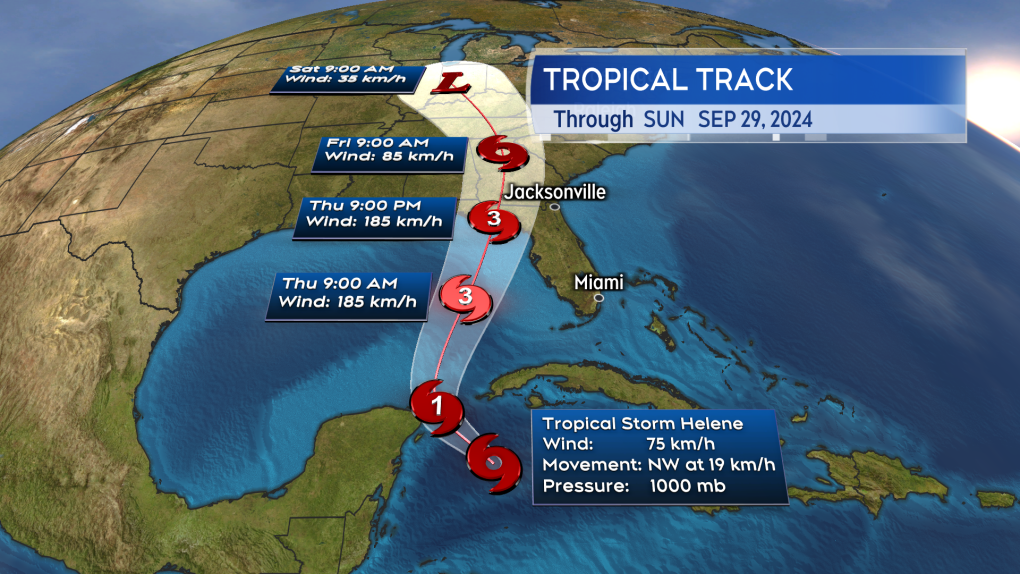 Helene is forecast to move into the Gulf of Mexico and intensify to a category-three hurricane before making landfall in Florida. (Source: CTV News Atlantic)
Hurricane watches issued
The National Hurricane Center has issued a number of hurricane and tropical storm alerts stretching from Cuba and the tip of the Yucatan Peninsula of Mexico to Florida.
As of noon on Tuesday, a Hurricane Watch is in effect for:
- Cabo Catoche to Tulum, Mexico
- Cuban province of Pinar del Rio
- Englewood to Indian Pass
- Tampa Bay
A Tropical Storm Warning is in effect for:
- Dry Tortugas
- Lower Florida Keys west of the Seven Mile Bridge
- Grand Cayman
- Rio Lagartos to Tulum, Mexico
- Cuban provinces of Artemisa, Pinar del Rio, and the Isle of Youth
A Tropical Storm Watch is in effect for:
- Middle Florida Keys from the Seven Mile Bridge to the Channel 5 Bridge
- Flamingo to south of Englewood
- West of Indian Pass to Walton Bay County line
The National Weather Service offices of Florida have issued a Hurricane Watch stretching from near Tallahassee on the panhandle to south of Tampa Bay. A Tropical Storm Watch extending inland to Orlando. A Tropical Storm Warning means tropical storm conditions are expected within 36 hours. A Tropical Storm Watch means tropical storm conditions are possible within 48 hours. A Hurricane Watch means that hurricane conditions are possible within 48 hours.
Both weather agencies remind the public to adhere to official guidance on hazards and safety.
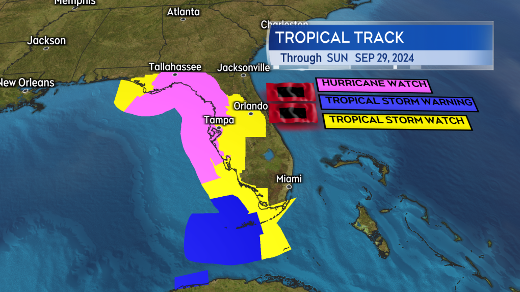 Watches and warnings issued by weather agencies in the US ahead of the arrival of Helene. (Source: CTV News Atlantic)
Storm surge and heavy inland rain hazards
Due to the approach and intensity of the storm, extensive storm surge is possible on parts of the western Florida coastline. Some of the most extensive surge forecast for the area begins near Crystal River, FL, and extends north along the coast to near St. Marks, FL. In some areas, the storm surge may bring water levels to more than 2.7 metres (nine feet) above the ground.
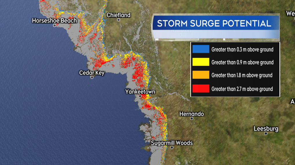 Preliminary storm surge potential for parts of Gulf of Mexico coastline of Florida. (Source: CTV News Atlantic)
Weather model guidance for the storm indicates rain totals that could range from 100-to-200 mm are a risk for northern Florida, eastern Alabama and Tennessee, as well as western parts of Georgia, South Carolina, and North Carolina. That amount of rain could bring a considerable amount of flash and urban flooding.
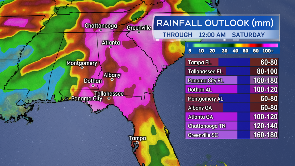 Rain totals of well in excess of 100 mm are indicated as a risk for parts of the southeastern United States. (Source: CTV News Atlantic)
No major impacts from the storm are expected in Canada. Some of the last rain associated with the storm could brush into southern Ontario this upcoming weekend. There is considerable uncertainty in that though as it will largely depend on what happens with the system once it is inland in the southeastern United States.


CTVNews.ca Top Stories

DEVELOPING
DEVELOPING 'A carbon tax election': MPs debate Conservative non-confidence motion in Liberal government
MPs in the House of Commons are debating the Conservatives’ non-confidence motion today, with Conservative Leader Pierre Poilievre calling for 'a carbon tax election,' and a return to what he called 'the Canadian promise' in a 20-minute speech.
EXCLUSIVE
EXCLUSIVE Image released of mysterious object shot down over Yukon in 2023
An image of the unidentified object shot down over Canada's Yukon territory in February 2023 has been obtained by CTVNews.ca.
Couple in Sault Ste. Marie, Ont., awarded more than $500K for enduring life with hellish neighbour
We've all had neighbours we didn't like, but two people from Sault Ste. Marie have been awarded more than half a million dollars for the 'extreme' behaviour of the people who lived next to them.
Police arrest five people in Spain over fake Brad Pitt scam after two women lost US$362,000
Police in Spain have arrested five people accused of scamming two women out of 325,000 euros (US$362,000) by pretending to be Hollywood star Brad Pitt online.
Health Canada approves Pfizer-BioNTech's updated COVID-19 vaccine
Health Canada has approved Pfizer-BioNTech's updated COVID-19 vaccine that protects against one of the most recently circulating variants of the virus.
Canadians in Lebanon told to get out while flights available, don't wait for government evacuation
The federal government is advising Canadians in Lebanon to leave now while commercial flights are available, saying, 'Canada is not currently offering assisted departures or evacuations.'
Pro Football Hall of Fame quarterback Brett Favre has Parkinson's
Pro Football Hall of Fame quarterback Brett Favre revealed Tuesday at a hearing on federal welfare reform that he has been diagnosed with Parkinson's disease.
Ontario woman seen in viral video of Porsche theft now facing more charges
An 18-year-old woman who allegedly stole a Porsche and then ran over its owner in a caught-on-video incident in Mississauga earlier this month is now facing auto theft charges in Toronto.
Bank of Canada says it's reasonable to expect more rate cuts
Given the continued progress the Bank of Canada has made in bringing inflation back down to the 2 per cent target, it is reasonable to expect more rate cuts, Governor Tiff Macklem said on Tuesday.
Shopping Trends
The Shopping Trends team is independent of the journalists at CTV News. We may earn a commission when you use our links to shop. Read about us.


Toronto
-

Ontario woman seen in viral video of Porsche theft now facing more charges
An 18-year-old woman who allegedly stole a Porsche and then ran over its owner in a caught-on-video incident in Mississauga earlier this month is now facing auto theft charges in Toronto.
-
What you need to know about RSV and new vaccines in Ontario
Respiratory syncytial virus, or RSV, season is just a few months away, but new vaccine options have already arrived for Ontario residents who may be vulnerable to the winter bug.
-
'We need to get these folks back working': Doug Ford stands behind comments on encampments amid backlash
Premier Doug Ford is standing behind comments he made suggesting that people living in encampments “just need to get a job to lift themselves out of poverty.”
Calgary
-

Premier Danielle Smith announces plan to change Alberta Bill of Rights
Premier Danielle Smith says she plans to reinforce the right to decide whether to receive a vaccination or other medical procedure in changes to the Alberta Bill of Rights.
-
Calgary man faces child porn charges after 'incredibly disturbing' messages found: ALERT
A Calgary man is facing child pornography charges after an investigation uncovered years of messages exchanged with an alleged felon.
-
EXCLUSIVE
EXCLUSIVE Image released of mysterious object shot down over Yukon in 2023
An image of the unidentified object shot down over Canada's Yukon territory in February 2023 has been obtained by CTVNews.ca.
Edmonton
-

LRT passenger hospitalized after collision with semi
One person was hospitalized after a crash involving a Valley Line Southeast LRT train and a semi Tuesday morning.
-
Meeting with Alberta MLA who compared trans youth to feces went south: advocates
A transgender Albertan says it would be a slap in the face if Premier Danielle Smith allows back into the government caucus a member who once compared transgender children to feces.
-
Premier Danielle Smith announces plan to change Alberta Bill of Rights
Premier Danielle Smith says she plans to reinforce the right to decide whether to receive a vaccination or other medical procedure in changes to the Alberta Bill of Rights.
Montreal
-

Quebec premier under pressure over $7-billion Northvolt battery plant
The heat is rising for Quebec Premier François Legault as opposition parties demand answers about his government's investment in the planned Northvolt battery factory near Montreal.
-
Port of Montreal container fire brought under control
A fire in a container at one of the Port of Montreal's terminals prompted the city to issue a containment notice for the area adjacent to the port on Monday evening, in the Mercier--Hochelaga-Maisonneuve borough.
-
78 stolen vehicles seized in Montreal port in one month as numbers continue to skyrocket
The Canada Border Services Agency (CBSA) reported this week that officers in the agency's Montreal Marine and Rail Services seized 78 vehicles and transferred them to police. Numbers of stolen vehicles in Quebec continue to skyrocket.
Ottawa
-

Lockdown lifted at Glebe Collegiate
Ottawa police say there is an ongoing investigation at Glebe Collegiate Institute.
-
Man arrested following assault on 'multiple' OC Transpo passengers Monday
Ottawa police say a 26-year-old man has been arrested following a several assaults on passengers travelling on OC Transpo vehicles Monday morning.
-
Ottawa police mounted unit to aid in missing persons searches, protests
Stubbs said last week that the Ottawa Police Service would be bringing back a unit on horseback to patrol certain areas, most notably the ByWard Market. But speaking to reporters Monday, he added the unit will have other uses.
London
-

Anti-drag queen protestor found not guilty in criminal harassment case
A London man charged with criminal harassment following an incident outside the Parkhill Public Library during a Drag Queen story reading on April 29, 2023, has been found not guilty.
-
Busloads of students at rental house in London, Ont. sparks call to tighten rules
The calls are growing louder for city council to tighten the rules governing short-term accommodations, including those advertised on websites like Airbnb and Vrbo, after students arrived by the busload at a rented house in the Masonville neighbourhood.
-
Local prostate cancer survivor sharing men's health message around the world
Todd Thompson never imagined he would raise over $100,000 towards men's cancer and mental health programs in just a few short years. That's because he was entirely cancer-free, a few years ago.
Barrie
-

Quick-thinking construction workers stop armed suspect from escaping
Three construction workers are being praised for their actions that police in Barrie say likely prevented an armed man from fleeing before being taken into custody.
-
Driver rescues abandoned puppies found in ditch on County Road 21 in Essa Township
Four puppies were found near County Road 21 in Essa after a passerby spotted one when it ran out of the ditch and onto the road.
-
Uber driver handed driving ban for failing to stop after crash that killed dog
An Uber driver was handed a 12-month driving ban on Tuesday following a collision that injured a pedestrian and killed a dog in Barrie.
Northern Ontario
-

Couple in Sault Ste. Marie, Ont., awarded more than $500K for enduring life with hellish neighbour
We've all had neighbours we didn't like, but two people from Sault Ste. Marie have been awarded more than half a million dollars for the 'extreme' behaviour of the people who lived next to them.
-
EXCLUSIVE
EXCLUSIVE Image released of mysterious object shot down over Yukon in 2023
An image of the unidentified object shot down over Canada's Yukon territory in February 2023 has been obtained by CTVNews.ca.
-
Local driver charged in fatal Highway 17 crash in Verner
A Verner man, 35, is charged in connection with a fatal crash on Highway 17 last month that killed one and sent another to hospital.
Kitchener
-

Reward of up to $50K offered for information in Joshua Bennett murder
A reward of up to $50K has been issued by Waterloo Regional Police for information leading to the conviction of the person or persons responsible for the fatal stabbing of 18-year-old Joshua Bennett.
-
EXCLUSIVE
EXCLUSIVE Image released of mysterious object shot down over Yukon in 2023
An image of the unidentified object shot down over Canada's Yukon territory in February 2023 has been obtained by CTVNews.ca.
-
Man charged with attempted murder following stabbing incident in Waterloo
Police were called to a business in the area of University Avenue East and Weber Street North at around 10:40 p.m. Saturday for a report of a man attempting to stab another man.
Windsor
-

Robbery suspect sought after convenience store incident
Windsor police officers are asking for the public’s help identifying and finding a suspect after a convenience store robbery in south Windsor.
-
Mail boat rescues man trying to swim across Detroit River
A man swimming across the Detroit River from Windsor to Detroit was rescued by a mail boat, according to the J.W. Westcott Company.
-
Deer cools off in Tecumseh backyard pool
Residents living in a Tecumseh neighbourhood had an unusual sighting over the weekend.
Winnipeg
-

Delivering a helping hand; how Winnipeg postal employees are going the distance on the job
An ordinary day on the job delivering mail in East Elmwood quickly turned dramatic for Canada Post letter carrier Jared Plourde. A woman on his route was calling out in distress.
-
Multiple juvenile zebra mussels found in Cleark Lake: Parks Canada
Parks Canada said it is considering treatment options and bringing in third-party experts after multiple, living juvenile zebra mussels were once again discovered in Clear Lake.
-
25,000 Manitoba health-care support workers to strike if deal can’t be reached by deadline
Unions representing roughly 25,000 health-care support workers have issued a strike notice, alerting the province its members will walk off the job if a deal is not reached before a looming deadline.
Regina
-

Saskatchewan report says proposed federal oil and gas cap would cause economic damage
A report from a tribunal appointed by the Saskatchewan Party government says a proposed federal emissions cap and methane regulations would cause severe economic damage.
-
Sask.'s two major parties trade ideas on how to improve health care
Health care is shaping up to be a major issue for this fall’s provincial election in Saskatchewan and on Monday both the Sask. Party and NDP announced plans on how they will work to improve the sector if elected this fall.
-
Traffic blitz underway in Regina. Here's what police are looking for.
Regina police will be conducting a two-day traffic blitz in and around the city Tuesday and Wednesday.
Saskatoon
-

Saskatoon group caught with kilos of meth is back on trial after judge overturns acquittal
A man and woman in Saskatoon who had two kilograms of methamphetamine seized from a home are going back to trial after having their acquittals overturned.
-
Sask. court hears arguments from province, UR Pride in Parents' Bill of Rights appeal
The Saskatchewan Government is in the province's highest court fighting to prevent a Court of King’s Bench judge from determining if its Parents' Bill of Rights actually violates the Charter.
-
Candle Lake Golf Course restaurant may be a total loss after early morning fire
Fire crews are battling a blaze at the Candle Lake Golf Course clubhouse on Monday morning.
Vancouver
-

Video shows black bear chasing B.C. man out of his garage
Video of a B.C. man's surprise encounter with a black bear has gone viral online, generating much discussion about how to best respond when face-to-face with an aggressive animal.
-
Concerns about food supply chain as Metro Vancouver grain workers launch strike
Metro Vancouver grain terminal workers are now on strike, bringing tens of millions of dollars of exports to a standstill.
-
EXCLUSIVE
EXCLUSIVE Image released of mysterious object shot down over Yukon in 2023
An image of the unidentified object shot down over Canada's Yukon territory in February 2023 has been obtained by CTVNews.ca.
Vancouver Island
-

Pair charged after 'significant seizure' of drugs, guns in Nanaimo, B.C.
A man and a woman from Nanaimo, B.C., are facing more than two dozen charges after police seized four guns and several hundred grams of illicit drugs following a complaint about drug trafficking in the city's downtown core.
-
Greens vow to expand safer supply of drugs in B.C., ex-coroner Lapointe backs plan
Former British Columbia chief coroner Lisa Lapointe has emerged from retirement to throw her weight behind a BC Green's campaign pledge to expand safer supply of opioids and other drugs to deal with the province's deadly overdose crisis.
-
Video shows black bear chasing B.C. man out of his garage
Video of a B.C. man's surprise encounter with a black bear has gone viral online, generating much discussion about how to best respond when face-to-face with an aggressive animal.
Kelowna
-

'Don't know where the animals came from': Runaway pigs rounded up in West Kelowna, B.C.
A pair of runaway pigs are in the custody of an animal sanctuary in the Okanagan after evading police and volunteers for hours earlier this week.
-
Video shows historic bridge in Kamloops, B.C., collapsing after fire
The Red Bridge, a historic landmark in Kamloops, B.C., was completely destroyed by fire early Thursday morning.
-
Pregnant pit bull with 10 puppies rescued from rat-infested B.C. home
Animal protection officers in British Columbia have rescued three pit bulls – including one that gave birth to 10 puppies – from a rat-infested home in Kelowna.


