Rain and downpours for the Maritimes; Hurricane Milton to impact both Mexico and Florida
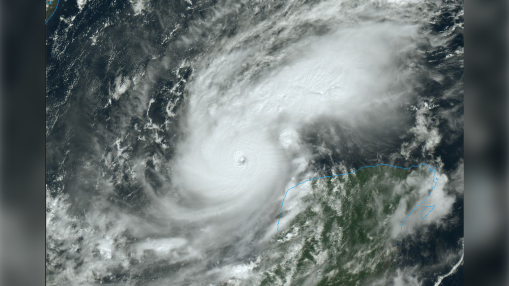 The eye of a very dangerous Category 5 Hurricane Milton clearly visible on high resolution satellite imagery courtesy of the College of DuPage.
It’s a soggy start to the second week of October for the Maritimes as a band of rain and downpours moves in slowly from the west. An already extremely powerful and dangerous Hurricane Milton is expected to strengthen further on its way to impact both Mexico and Florida.
Maritime rain and downpours
A slow-moving weather front will push rain across the Maritimes Monday through early Wednesday morning.
Rain and downpours will move into western New Brunswick Monday afternoon and evening. The risk of downpours is lower Monday night into Tuesday morning, but rain, drizzle, and fog will be present across the Maritimes.
There will be rain and downpours for New Brunswick and western Nova Scotia Tuesday morning and afternoon. The rain and downpours then shift into Prince Edward Island and eastern Nova Scotia, including Cape Breton, Tuesday evening and night. The last of the rain will clear Cape Breton early Wednesday morning.
The system has had a history of producing rainfall rates of 20 to 40 mm/hr in downpours. That rate of rain increases the risk of flash flooding. It will also reduce visibility on roads and create hydroplaning conditions.
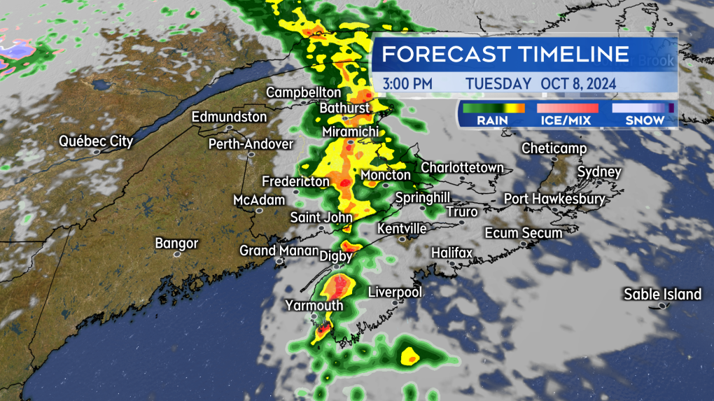 Rain and downpours will continue to move slowly west-to-east across the Maritimes on Tuesday.
Rain amounts
The front is expected to produce a general 10 to 40 mm of rain across the Maritimes. Due to the presence of downpours, local rain totals could be as much as 40 to 75 mm. One area with a higher risk of the heavier rain is parts of northern and western New Brunswick. The eastern half of Restigouche County, including Campbellton-Dalhousie, along with Bathurst and the Acadian Peninsula, should be especially cautious of a period of heavier rain. Just across the Bay of Chaleur, the Gaspe Peninsula of Quebec is under a rainfall warning, with totals of 60 to 90 mm expected.
The rain is needed in the Maritimes after a dry stretch through much of September and into the first week of October. We just need to be cautious of the downpours along with it.
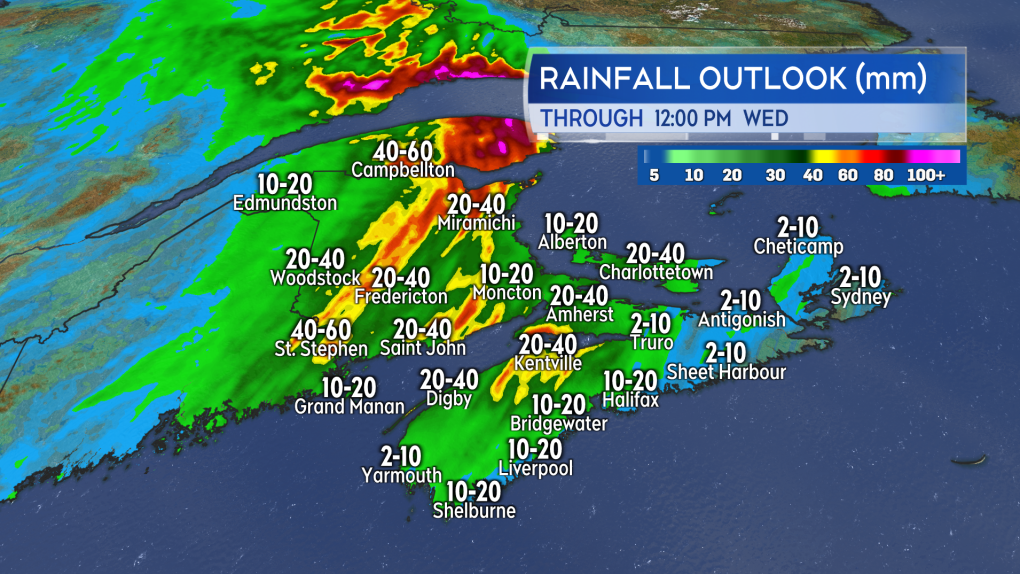 A general 10 to 40 mm of rain, with pockets of 40 to 75 mm due to downpours, is expected Monday through early Wednesday in the Maritimes.
Hurricane Milton strengthens to Category 5
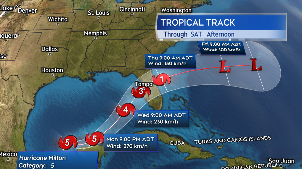
In a special update issued at 12:55 PM ADT, the National Hurricane Center of the United States declared Hurricane Milton a Category 5, with maximum sustained winds of near 260 km/h near the eye. This was based off data received from an Air Force Reserve Hurricane Hunter aircraft.
The extremely dangerous storm may see winds strengthen further to near 270 km/h as it moves past the northern coastline of the Yucatan Peninsula of Mexico Monday night into Tuesday morning. A storm surge of 1.2 to 1.8 metres (4 to 6 feet) is expected on portions of that coastline. Hurricane and tropical storm force winds are also expected for the northern Yucatan.
 The forecast cone for Hurricane Milton from the National Hurricane Center.
Milton will then cross the Gulf of Mexico to make landfall Wednesday night in western Florida as either a Category 4 or very strong Category 3 hurricane. The landfall point is expected to be somewhere between Cedar Key on the northern point of the cone, to Fort Myers on the southern point of the cone. Tampa is located nearly dead center of the cone. The storm is then expected to exit east of Florida into the Atlantic ocean by Thursday morning moving towards Bermuda as it weakens to a post-tropical area of low pressure.
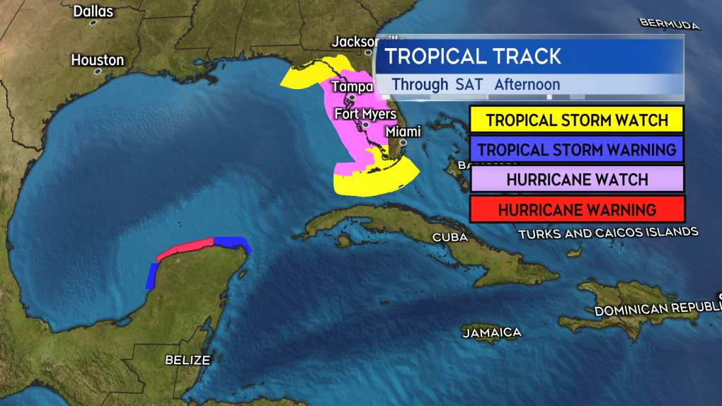 Hurricane and tropical storm watches and warnings extend from the Yucatan Peninsula of Mexico to Florida.
A storm surge of 1.2 to 3.7 metres (4 to 7 feet) is expected for parts of the western Florida coastline. Some of the highest storm surge is possible around the city of Tampa. Flooding inland rain of 100 to nearly 400 mm is expected for parts of the state. The area from Tampa north to Cedary Key and then across to St. Augustine looks most at risk for the very heaviest of the rain. Pockets of rain over 100 mm could be seen as far south as Key West though. The overall impact of the rain to the southeastern U.S. (not including Florida) will likely be less than with Hurricane Helene due to Milton moving back out over the Atlantic Ocean on Thursday.
The storm will also be accompanied by hurricane and tropical storm force winds for a large area of Florida. Much of western Florida is under either a hurricane watch or a tropical storm watch.
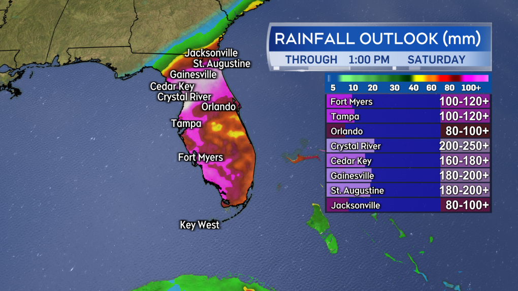 Storm surge and a flooding inland rain are expected for parts of Florida.


CTVNews.ca Top Stories

BREAKING
BREAKING Donald Trump picks former U.S. congressman Pete Hoekstra as ambassador to Canada
U.S. president-elect Donald Trump has nominated former diplomat and U.S. congressman Pete Hoekstra to be the American ambassador to Canada.
Genetic evidence backs up COVID-19 origin theory that pandemic started in seafood market
A group of researchers say they have more evidence to suggest the COVID-19 pandemic started in a Chinese seafood market where it spread from infected animals to humans. The evidence is laid out in a recent study published in Cell, a scientific journal, nearly five years after the first known COVID-19 outbreak.
This is how much money you need to make to buy a house in Canada's largest cities
The average salary needed to buy a home keeps inching down in cities across Canada, according to the latest data.
'My two daughters were sleeping': London Ont. family in shock after their home riddled with gunfire
A London father and son they’re shocked and confused after their home was riddled with bullets while young children were sleeping inside.
Smuggler arrested with 300 tarantulas strapped to his body
Police in Peru have arrested a man caught trying to leave the country with 320 tarantulas, 110 centipedes and nine bullet ants strapped to his body.
Boissonnault out of cabinet to 'focus on clearing the allegations,' Trudeau announces
Prime Minister Justin Trudeau has announced embattled minister Randy Boissonnault is out of cabinet.
Baby dies after being reported missing in midtown Toronto: police
A four-month-old baby is dead after what Toronto police are calling a “suspicious incident” at a Toronto Community Housing building in the city’s midtown area on Wednesday afternoon.
Sask. woman who refused to provide breath sample did not break the law, court finds
A Saskatchewan woman who refused to provide a breath sample after being stopped by police in Regina did not break the law – as the officer's request was deemed not lawful given the circumstances.
Parole board reverses decision and will allow families of Paul Bernardo's victims to attend upcoming parole hearing in person
The families of the victims of Paul Bernardo will be allowed to attend the serial killer’s upcoming parole hearing in person, the Parole Board of Canada (PBC) says.
Shopping Trends
The Shopping Trends team is independent of the journalists at CTV News. We may earn a commission when you use our links to shop. Read about us.


Toronto
-

Baby dies after being reported missing in midtown Toronto: police
A four-month-old baby is dead after what Toronto police are calling a “suspicious incident” at a Toronto Community Housing building in the city’s midtown area on Wednesday afternoon.
-
Markham man agrees to remove backyard hockey rink after years-long faceoff with city, neighbours
A Markham hockey buff who built a massive backyard ice rink without permissions or permits has reluctantly agreed to remove the sprawling surface, following a years-long dispute with the city and his neighbours.
-
Toronto moving to install side guards on its heavy trucks to reduce pedestrian and cyclist deaths
Toronto is looking to retrofit its heavy-duty vehicles with side guards in an effort to reduce pedestrian deaths.
Calgary
-

Calgary gorilla died after being hit by a door: officials
The Calgary Zoo says its two-year-old western lowland gorilla named Eyare died after being hit by a hydraulic door at the rear of the exhibit.
-
‘She’s an entertainer through and through’: 100-year-old Calendar Girl steals the show in Nanton
There is quite the buzz around the small southern Alberta town of Nanton over its fall stage production, and for more reasons than one.
-
Police investigating Hillhurst fire they believe was deliberately set
Calgary police are seeking public assistance in relation to a Tuesday fire in Hillhurst that they believe was deliberately set.
Edmonton
-

Canada Post strike double-edged sword for local businesses
As we head into the holiday season, one Edmonton small business owner says she's shutting down online orders – something not all businesses may be able to do
-
Former PM Stephen Harper appointed to oversee Alberta's $160B AIMCo fund manager
Former prime minister Stephen Harper is the new chairman of the Alberta Investment Management Corporation, or AIMCo, which oversees more than $160 billion in funds, including pension funds and the Heritage Savings Trust Fund.
-
Edmonton police chief to step down in February
Dale McFee will retire as head of the Edmonton Police Service (EPS) on Feb. 21, the Edmonton Police Commission said in an email on Wednesday.
Montreal
-

Sante Quebec extends transition period for dual-job health care workers
Facing criticism for requiring health care workers with two jobs within the public system to choose one to comply with labour laws, Santé Québec has announced a one-year extension to the transition period.
-
Family forced to leave home for STM's new ventilation station
A family in Rosemont-La-Petite-Patrie is facing an emotional upheaval as the STM moves forward with expropriating their home for a new mechanical ventilation station to serve the Orange Line.
-
Couple faces trial for alleged kidnapping and assault of teen over prank
A Saint-Sauveur couple was back in court on Wednesday, accused of attacking a teenager over a prank.
Ottawa
-

TransitNext submits ‘substantial completion notice’ for Trillium Line
The consortium responsible for building Ottawa's new north-south line, TransitNext, says it is ready for the City of Ottawa to begin the final phase of approvals before opening the line to the public.
-
Here's where 39 photo radar cameras will be installed in Ottawa over the next 14 months
Thirty-nine new photo radar cameras will be installed to keep an eye on Ottawa roads over the next 14 months, including on roads in the rural villages of Dunrobin, Manotick, Richmond and Vars.
-
High-end fitness gym Altea Ottawa opens on Wednesday
One of Canada's premier high-end gym chains is set to open in Ottawa on Wednesday.
London
-

'My two daughters were sleeping': London Ont. family in shock after their home riddled with gunfire
A London father and son they’re shocked and confused after their home was riddled with bullets while young children were sleeping inside.
-
'They were pausing it': One of the largest alcoholic beverage companies in the world has put a hold on a St. Clair Township plant
They were raising a glass to a new business in St. Clair Township, but now it appears the cap has to go back on the bottle.
-
'A slap in the face': Defence wants three years for man who killed 11-year-old St. Thomas boy while driving impaired
Back in July, Nicolas Lemke plead guilty to impaired driving causing the death of Aiden Curtis, and impaired driving causing bodily harm to two other adults who were injured.
Barrie
-

Possible explosives found inside RV after 16 hour standoff in Barrie, Ont. parking lot
Several apparent homemade explosive devices were found inside an RV where an allegedly armed man had barricaded himself for 16 hours, forcing evacuations in the north end of Barrie, police said.
-
Coalition of councillors oppose use of notwithstanding clause to deal with encampments
Weeks after more than a dozen mayors, including Barrie mayor Alex Nuttall, signed a letter to Premier Doug Ford asking him to consider using the notwithstanding clause as cities struggle with how to handle growing encampments, a coalition of councillors are speaking out against its potential use.
-
Winter patios coming to downtown Barrie
With some milder winters in recent years Barrie city councillors are exploring if there's an appetite to dine outdoors in the coldest months of the year.
Northern Ontario
-

Unattended cooking to blame for North Bay house fire, landlord fined
The owner at a North Bay rental home has been fined and seven people displaced after a kitchen fire Tuesday.
-
Sudbury ponders options to fix crumbling College Street underpass, city's oldest bridge
Next week, Sudbury city council will decide how to rehabilitate the College Street underpass, which was built in 1949.
-
Swiftie's friendship bracelet beads confiscated at Calgary airport
A Canadian Taylor Swift fan has some 'Bad Blood' with the Calgary International Airport after security staff confiscated hundreds of dollars worth of beads she was going to use to make friendship bracelets.
Kitchener
-

Man who stabbed ex-girlfriend and police officer will soon be out on statutory release
A man who plead guilty to a double stabbing in 2015 will soon be out on statutory release, but he'll have to follow some strict conditions set out by the parole board.
-
Pricey WRPS budget sparks hours-long debate with regional councillors
The Waterloo Regional Police Service presented their 2025 budget, totaling $252.5 million, to the Region of Waterloo’s Strategic Planning and Budget Committee on Wednesday morning.
-
Parole board reverses decision and will allow families of Paul Bernardo's victims to attend upcoming parole hearing in person
The families of the victims of Paul Bernardo will be allowed to attend the serial killer’s upcoming parole hearing in person, the Parole Board of Canada (PBC) says.
Windsor
-
 video
videovideo Windsor man pleads guilty to alcohol-fuelled stabbing of his partner
*WARNING: This story contains graphic content that some may find disturbing. Reader's discretion is advised.*
-
video
video As Town of Essex faces six per cent tax increase, why are so many municipalities' budgets stretched?
Town of Essex councillors have voted not to move ahead with a hiring freeze meant to tackle a six per cent tax levy increase that is currently on the table.
-
video
video Holiday light by-law drives family out of Kingsville
A Kingsville family, who for years put up elaborate Christmas lights and decor outside their home on Marshwoods Boulevard, has instead put up a for sale sign this year.
Winnipeg
-

'It's definitely frightening': Woman warns of scammers posing as Manitoba Hydro workers
A Winnipeg woman is warning others to be on guard after she was nearly duped by an elaborate scam involving fake Manitoba Hydro workers, Bitcoin machines, and a “frightening” amount of her own personal information.
-
Contraband cigarettes impacting tax dollars according to new report
Illegal cigarettes in Manitoba are taking a big chunk out of the market.
-
Muddy riverbank finds reveal Winnipeg’s past
A recent drop in river levels is turning back the pages of time in Winnipeg and opening the doors to a hobby that is attracting people who aren’t afraid to get their feet wet and their hands dirty with an interest in Manitoba history, also known as mudlarking.
Regina
-

Former Sask. Party MLA Greg Lawrence pleads guilty in assault case
Former Saskatchewan Party MLA Greg Lawrence has been sentenced to 12 months probation – after pleading guilty to one count of assault.
-
Sask. woman who refused to provide breath sample did not break the law, court finds
A Saskatchewan woman who refused to provide a breath sample after being stopped by police in Regina did not break the law – as the officer's request was deemed not lawful given the circumstances.
-
Winter storm creates treacherous driving conditions in Regina and around southern Sask.
Many commuters in and outside of Regina are facing tough driving conditions Wednesday morning following a significant snowfall on Tuesday that has closed highways and snarled traffic on many of the city's main throughfares.
Saskatoon
-

Saskatchewan teen still recovering in hospital after being set on fire at school
A 15-year-old girl who was set on fire at a Saskatoon high school earlier this fall is still recovering in hospital.
-
Saskatoon teen pleads guilty in high-speed crash that killed 16-year-old
A Saskatoon teen accused of driving a car involved in a high-speed crash that killed a 16-year-old last spring has pleaded guilty to his charges.
-
Former Sask. Party MLA Greg Lawrence pleads guilty in assault case
Former Saskatchewan Party MLA Greg Lawrence has been sentenced to 12 months probation – after pleading guilty to one count of assault.
Vancouver
-

BC Hydro reports 'extensive damage' from bomb cyclone that left 300,000 in the dark
Several thousand British Columbians remain in the dark Wednesday morning after a windstorm known as a bomb cyclone slammed coastal communities.
-
EXCLUSIVE
EXCLUSIVE UBC investigating instructor following leaked audio of anti-Israel rant
A UBC instructor is facing backlash following the release of a 12-minute audio file from a lecture she gave on Sept. 18.
-
Near-record gusts knock out power to 150K Vancouver Island customers; BC Hydro brings in reinforcements from mainland
The clean up was well underway Wednesday on Vancouver Island after a night of chaos.
Vancouver Island
-

Near-record gusts knock out power to 150K Vancouver Island customers; BC Hydro brings in reinforcements from mainland
The clean up was well underway Wednesday on Vancouver Island after a night of chaos.
-
BC Hydro reports 'extensive damage' from bomb cyclone that left 300,000 in the dark
Several thousand British Columbians remain in the dark Wednesday morning after a windstorm known as a bomb cyclone slammed coastal communities.
-
1 unaccounted for after Nanaimo house fire, police say
One person is unaccounted for after a fire that destroyed a home in Nanaimo's south end Wednesday morning.
Kelowna
-

Man in hospital following targeted shooting in Kamloops
Police are appealing for information on a targeted shooting that resulted in the hospitalization of a man in Kamloops.
-
Police cleared of fault in fatal 2023 crash in B.C.'s Interior
British Columbia's independent police watchdog has cleared officers of wrongdoing in a crash where three people were killed south of Kamloops in July of last year.
-
B.C. woman sentenced for stealing $14K in funds raised for schoolkids
A B.C. woman who stole more than $14,000 in volunteer-raised funds that were supposed to be spent on school supplies and programs – including hot meals for vulnerable kids – won't spend any time in jail.


