Showery weather Tuesday could help lower wildfire danger risks
A round of rain and showers will continue across central/southern New Brunswick as well as mainland Nova Scotia Tuesday afternoon into evening. A chance of showers for northern New Brunswick, Cape Breton, and Prince Edward Island.
There is a low risk of very isolated downpours and small thunderstorms within the wet weather. The downpours may be capable of producing rain rates of between 10 and 30 mm/hr. That’s enough to reduce visibility if driving through one and lead to hydroplaning conditions on the roads. Repeating downpours that could lead to more extensive flooding are not expected.
A severe thunderstorm watch was issued late Tuesday morning for Fredericton and Southern York County as a few small thunderstorms developed in the area. The watch ended shortly after noon on Tuesday but was replaced with a rainfall warning.
The risk of any further downpours and thunderstorms is expected to diminish considerably by Tuesday evening.
Rain amounts for most areas will range from trace to 5 mm. Localized rain totals of 10 to 30 mm are possible in the event of a downpour or thunderstorm.
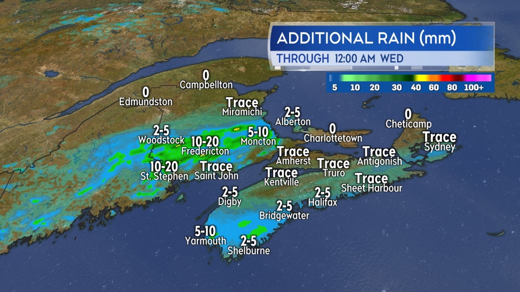 Mostly a light rainfall due to showery conditions expected on Tuesday. A few, very isolated downpours possible along with the showers.
National and regional wildfire danger
The summer rain and showers in the Maritime region Tuesday are beneficial in lowering our fire danger risk.
Natural Resources Canada currently has much of the Maritimes in a low-to-moderate risk rating. A few spots in northeastern New Brunswick, eastern Nova Scotia, and Prince Edward Island are in a high risk. Remember to check daily on any provincial/municipal burn restrictions before having an outdoor fire.
In the west of the country, large areas of southern British Columbia, Alberta, Saskatchewan, and the Northwest Territories are under a high-to-extreme risk. Wildfires have triggered a number of evacuations including near Jasper National Park, Alta., and Williams Lake, B.C.
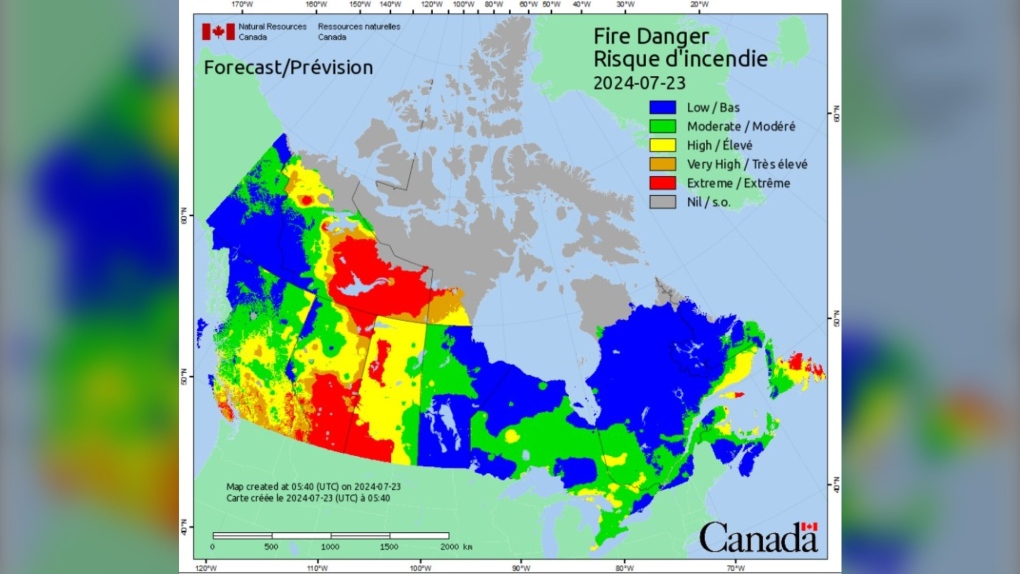 Wildfire danger ratings across the country on Tuesday per Natural Resources Canada.
A ridge of high pressure in the west has triggered a several day stretch of dry and hot weather aggravating the wildfire risk. The ridge has now broken down in B.C. with temperatures falling in that province. Some cooling is expected in northern areas of Alberta by Wednesday. There are some much needed showers in the forecast for the Jasper National Park area Wednesday night and Thursday.
A thin, high haze produced by smoke from the western wildfires was present in the sky over the Maritimes on Monday. The arrival of some of that thin, high smoke may have contributed to a more orange-reddish tinge to the rising moon on Sunday and Monday night in the Maritimes.
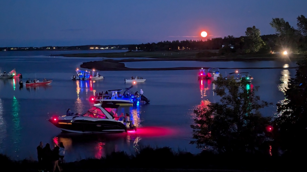 The rising moon Sunday evening as captured by Nicholas Bastarache in Bouctouche N.B.


CTVNews.ca Top Stories

Pakistani citizen arrested in Canada, charged with plotting terrorist attack in New York
A Pakistani citizen who resided in Canada has been charged with plotting a terrorist attack at a Jewish centre in New York City.
Assembly of Manitoba Chiefs Grand Chief Cathy Merrick dies after collapsing outside Winnipeg courthouse
The Grand Chief of the Assembly of Manitoba Chiefs has died after collapsing outside of the Manitoba courthouse Friday afternoon, according to multiple sources.
Woman who was denied a liver transplant, after review highlighted alcohol use, has died
Questions are being raised about the case of a 36-year-old Ontario woman who died of liver failure after she was rejected for a life-saving liver transplant after a medical review highlighted her prior alcohol use.
Montreal man given $664 fine for tying dog to parking meter while grabbing a croissant
A Montreal man who tied his dog to a parking meter while he entered a bakery is now facing a hefty fine for breaking a law he had no idea existed.
Canada-wide warrant issued for woman in fatal Toronto shooting
A 36-year-old woman is wanted for first-degree murder following a shooting near an after-hours club in Toronto earlier this month.
Molson Coors ends diversity, equity and inclusion policies, moves to 'broader view'
Brewing company Molson Coors says it is dropping its diversity, equity and inclusion policies and taking a 'broader view' in which all employees know they are welcome.
Selena Gomez is a billionaire
Selena Gomez can now add becoming a billionaire to her long list of achievements.
Teen girl charged with attempted murder after student set on fire at Saskatoon high school
A 14-year-old girl faces an attempted murder charge after a 15-year-old girl was doused in a flammable substance and set on fire at a Saskatoon high school Thursday.
Victim of Vancouver stranger attacks had surgery to reattach severed hand: police
The surviving victim of a pair of stranger attacks in downtown Vancouver on Wednesday has undergone surgery to reattach his hand after it was severed in the assault, according to police.
Shopping Trends
The Shopping Trends team is independent of the journalists at CTV News. We may earn a commission when you use our links to shop. Read about us.


Toronto
-

Canada-wide warrant issued for woman in fatal Toronto shooting
A 36-year-old woman is wanted for first-degree murder following a shooting near an after-hours club in Toronto earlier this month.
-
2 people critically injured in rollover on Highway 401 in Mississauga: paramedics
Two people have been critically injured in a vehicle rollover on Highway 401 in Mississauga, Peel paramedics say.
-
Marineland owner Marie Holer dies, park says 'succession plan' in place
Marineland's owner, Marie Holer, has died.
Calgary
-

Calgary mayor meets with province over Green Line, Feds 'surprised' by funding changes
Calgary Mayor Jyoti Gondek met with representatives from the Alberta government Friday, just days after councillors voted to start the process to 'wind down' the $6.2 billion Green Line and transfer the cost and risk to the provincial government.
-
Concerns raised over support backlog for children with disabilities
Families and advocates of children with disabilities are concerned about backlogs in the system leaving some without support.
-
'We are not going to stop looking for you': Alberta murder suspect still at large
Alberta RCMP are continuing their search for Elijah Strawberry, wanted in the death of a Rocky View County worker in early August.
Edmonton
-

Charges laid after motorcyclist posts video of dangerous driving on social media
A motorcyclist is facing multiple charges of driving dangerously after he posted social media videos of himself breaking the law.
-
Edmonton zoning changes pit lot owner against city over property value
A homeowner in a southside neighbourhood says his property is about to lose hundreds of thousands of dollars in value because of the City of Edmonton.
-
'We're going to be an economic powerhouse': River Cree breaks ground on $200M expansion
The River Cree Resort and Casino is planning to nearly double its size.
Montreal
-

RCMP arrests man in Quebec allegedly plotting terror attack on Jewish community in New York
The RCMP arrested a 20-year-old man who was allegedly in the process of planning a deadly terror attack targeting Jewish citizens in the United States. Muhammad Shahzeb Khan, also known as Shazeb Jadoon, was arrested on Wednesday in Ormstown, Que., located 61 km southwest of Montreal.
-
Quebec federal prison near Montreal to house high-risk immigration detainees
The Canadian Border Service Agency (CBSA) says it will start temporarily utilizing the Regional Reception Centre, a federal prison located in Sainte-Anne-des-Plaines, Que., to house a small number of high-risk immigration detainees.
-
Ottawa
-

Frustration for some federal public servants and executives mandated back to the office
Starting Monday, federal employees will be required to be in the office three days a week, instead of the current two, and that means another day dealing with a commute that some say has gotten worse.
-
Ottawa mother with son living with autism denied thousands of dollars in claims
An Ottawa mother says it’s been a nightmare dealing with her insurance company after she was denied tens of thousands of dollars worth of claims for her autistic son’s therapies.
-
Delayed Stittsville high school slated to open Sept. 17
The Ottawa-Carleton District School Board told families in a note Friday that Maplewood Secondary School should be ready to accept students starting Tuesday, Sept. 17, barring any unforeseen complications.
London
-

Why London might stop adding names to its urgent waitlist for Rent-Geared-To-Income Housing
A five-year waitlist and ongoing livability challenges at Rent-Geared-To-Income (RGI) Housing in the London-Middlesex region might prompt changes to how prospective tenants are prioritized when units become available.
-
Grand Bend dog recovering after overdosing on drugs at local park
You wouldn't know it by looking at her today, but Izzy, a high-energy three-year-old golden doodle, was on death's door less than two weeks ago.
-
Fuel truck rollover east of Goderich
Crews were called in after a fuel truck rolled over Friday near Goderich.
Barrie
-

Barrie police investigate collision involving pedestrian and 2 motorcycles
Police in Barrie are investigating a collision involving a pedestrian and two motorcycles on Thursday night.
-
Driver flees after hitting tow truck operator in Springwater: OPP
Provincial police are hoping to identify the driver of an SUV that allegedly struck a tow truck operator as he worked on the side of the road in Springwater Township and took off.
-
Vulnerable group camping in Barrie park in limbo as City’s eviction deadline passes
Tensions remain high on Friday at a park in Barrie after the City issued a three-day eviction to a group of people using the area as a campground earlier this week.
Northern Ontario
-
Pakistani citizen arrested in Canada, charged with plotting terrorist attack in New York
A Pakistani citizen who resided in Canada has been charged with plotting a terrorist attack at a Jewish centre in New York City.
-
Sudbury OPP officer pleads guilty to stealing evidence during moose hunt investigation
A veteran staff sergeant with the Ontario Provincial Police in Sudbury has been sentenced for stealing two items from a First Nations man and hiding what he did while his fellow officers searched for them.
-
Average of one impaired-related charge per day in Sudbury
Greater Sudbury Police Service say nine drivers were charged with impaired-related offences over the Labour Day long weekend.
Kitchener
-

Video shows physical interaction involving a police officer in Hanover, Ont.
Hanover’s police chief is responding to community concerns about a recent arrest at a Hanover school.
-
Waterloo, Ont. tech company blacklisted by U.S. Commerce Department over surveillance, spyware allegations
A Waterloo, Ont. tech company is in hot water for allegedly providing technology that can be used for mass surveillance and censorship.
-
Ontario's first domestic case of human rabies since 1967 confirmed in Brant County
An Ontario resident remains in hospital after testing positive for rabies.
Windsor
-

CTV News Windsor’s top stories from this week
In case you missed it, CTV News Windsor has compiled all of the top local stories from this week into one video.
-
SIU investigating fatal officer-involved shooting on Goyeau Street
Investigators with the Special Investigations Unit have been called to the scene of a fatal officer-involved shooting in Windsor.
-
'Taco Bear' gets new name while recovering after 10-hour trip to Windsor, Ont.
An injured black bear cub that survived a 10-hour drive to southwestern Ontario while being fed Taco Bell has been renamed "Windsor" following its new found connection to the Rose City.
Winnipeg
-

Assembly of Manitoba Chiefs Grand Chief Cathy Merrick dies after collapsing outside Winnipeg courthouse
The Grand Chief of the Assembly of Manitoba Chiefs has died after collapsing outside of the Manitoba courthouse Friday afternoon, according to multiple sources.
-
Manitoba jail guard acquitted of all charges in death of Indigenous inmate
A Manitoba judge acquitted a provincial corrections officer of all charges in the death of an Indigenous inmate following a violent stand-off in the jail more than three years ago.
-
Deteriorating former housing complex slated for demolition
A former low-income housing complex that’s been an eyesore in downtown Winnipeg for years is going to be torn down.
Regina
-

Regina police officers injured after apparent impaired driver collides with vehicle during traffic stop
Two Regina police officers were hurt early Friday morning when a vehicle being driven by an apparent impaired driver rear-ended their patrol unit during a traffic stop.
-
What winter in Sask. and rest of prairies could look like this year
The start of September marked meteorological fall and Sept. 22 at 6:43 a.m. will mark the 2024 fall equinox. That has winter on the minds of many even though hot weather is still in the forecast.
-
Labour Day Classic 50/50 highest in Roughriders regular season history
The recent Labour Day Classic 50/50 draw saw a record amount in Saskatchewan Roughriders regular season history.
Saskatoon
-

Teen girl charged with attempted murder after student set on fire at Saskatoon high school
A 14-year-old girl faces an attempted murder charge after a 15-year-old girl was doused in a flammable substance and set on fire at a Saskatoon high school Thursday.
-
Sask. dog owner says residents of Allan ran him out of town
The owner of a pack of dogs that drew the ire of residents of Allan, Sask. says he was run out of town after his neighbours grew fearful of his beloved pets.
-
Saskatoon’s newest emergency shelter will likely be downtown
A former Saskatchewan Transportation Company building located at 210 Pacific Avenue has been identified as a potential temporary site for an enhanced emergency shelter.
Vancouver
-

Suspect accused of random attacks in Vancouver had a history of court-ordered psychiatric care
Brendan Colin McBride, the man accused of killing one man and assaulting another in downtown Vancouver Wednesday, was identified by the courts as requiring counselling and forensic psychiatric services as part of a probation order in 2022.
-
Jury deliberations underway in trial of man accused of killing innocent teen during B.C. gang shooting
The fate of the man accused of fatally shooting a rival gang member and an innocent teen passerby in 2018 now lies in the hands of a B.C. Supreme Court jury.
-
Intruder breaks into Richmond daycare
It was a parent’s worst nightmare early Friday morning at a Richmond daycare, when an intruder broke into the centre.
Vancouver Island
-

B.C. senior responds to vandalism with creative kindness
Roger Barker was looking forward to exchanging a book at one of the Little Free Libraries that had been erected in his neighbourhood, until he found it vandalized.
-
Major crime unit called for suspicious death in Lake Cowichan, B.C.
Major crime investigators on Vancouver Island have been deployed to assist in a suspected homicide case.
-
Victim of Vancouver stranger attacks had surgery to reattach severed hand: police
The surviving victim of a pair of stranger attacks in downtown Vancouver on Wednesday has undergone surgery to reattach his hand after it was severed in the assault, according to police.
Kelowna
-

Charges laid in hit-and-run that killed Kelowna teen
A man has now been charged for his alleged role in a hit-and-run that killed a teenager in Kelowna, B.C., last fall.
-
Have you seen Lulu? Kelowna RCMP searching for stolen puppy
Mounties in Kelowna are appealing to the public for help reuniting a stolen puppy named Lulu with its owner.
-
RCMP issue 'strong warning' against unsanctioned pre-grad parties in B.C.'s Okanagan
Authorities are urging parents in B.C.'s Okanagan to speak with their teenagers about the dangers of attending "unsanctioned" pre-graduation parties.


