Snow totals from Maritime storm comparable to White Juan: More snow to come
 Incredibly high snow drifts making snow clearing extremely difficult in Sydney, N.S. (Courtesy: Terrylee McCarron)
White Juan comparison
The weekend long snowstorm is now approaching snow reports comparable to those seen with White Juan, the great blizzard of 2004, for parts of the Maritimes.
According to analysis by Environment Canada meteorologist Chris Fogarty, White Juan left a widespread swath of 60 to 90 cm of snow across Nova Scotia and eastern P.E.I. Feb. 18-19, 2004. Unofficial snow reports from White Juan had some totals in the range of 100 to 150 cm.
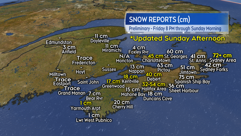
Snow reports from Sunday squarely put parts of central and eastern Nova Scotia as well as Prince Edward Island in that 40 to 80 cm range. CTV’s Chief meteorologist, Kalin Mitchell, says he recieved unofficial reports of snow amounts exceeding 80 cm in parts of Antigonish County as well as in Cape Breton. There are likely to be parts of Cape Breton that finish with near or above 100 cm of snow by Monday.
 Snowfall reports for Sunday, most of which are from Sunday morning updates from Sunday afternoon in yellow. Unofficial reports from areas of Antigonish County and Cape Breton have totals in excess of 80 cm. (CTV/Kalin Mitchell)It should be noted that White Juan hit with stronger winds contributing more in the way or power outages. Peak gusts with White Juan reached 80 to 100 km/h and up to near 120 km/h on exposed areas of the Atlantic coastline of Nova Scotia. Peak gusts with the current storm have ranged 50 to 80 km/h which has still been plenty enough to create extensive drifting and blowing snow along with periods of whiteout conditions.
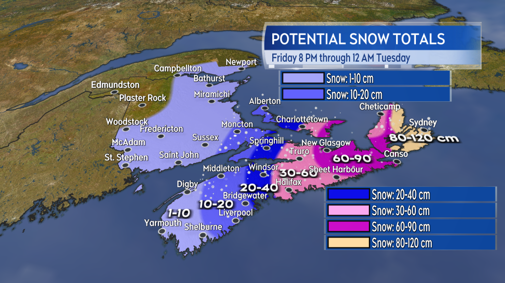
 An estimate of where we could finish with general snow totals last Friday evening through Monday. (CTV/Kalin Mitchell
More to come
As of Sunday afternoon some mixing in of ice pellets and rain with the snow has been reported in coastal areas of Richmond and Cape Breton Counties. The mix should help limit overall additional snow accumulations as long as it persists for those areas. It will continue to add weight to the accumulated snow.
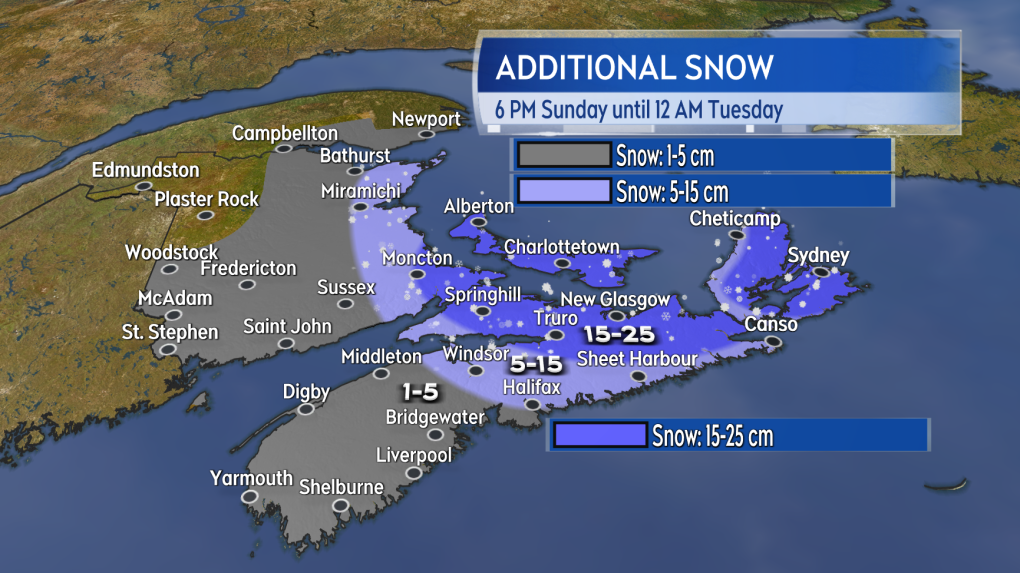
Bands of snow continues to wrap back into eastern mainland Nova Scotia and across Kings and Queens Counties in Prince Edward Island. It is also possible that some of the snow could reach Moncton and the southeast of New Brunswick, which could add up to near or more than 10 cm.
 Additional snow possible Sunday evening through Monday. (CTV/Kalin Mitchell)
Improvements when?
The snow becomes lighter and more intermittent Sunday night into Monday morning. Further flurries or periods of lighter snow are expected across the Maritimes on Monday. There’s a chance of flurries by Tuesday morning for southeastern New Brunswick, Prince Edward Island, and eastern Nova Scotia.
The northerly wind peaks Sunday evening. For Monday, it continues with gusts of 30 to 60 km/h, which is still enough to create drifting snow through the day. The drifting snow could still reduce visibility and put snow coverage back onto previously cleared surfaces. The wind diminishes to sustained 10 to 20 km/h with gusts of 20 to 40 km/h by Tuesday morning.
There are extensive storm travel disruptions and event cancellations. Check here for the latest on those.
CTVNews.ca Top Stories

BREAKING Real GDP per capita declines for 6th consecutive quarter, household savings rise
Statistics Canada says the economy grew at an annualized pace of one per cent during the third quarter, in line with economists' expectations.
W5 Investigates A 'ticking time bomb': Inside Syria's toughest prison holding accused high-ranking ISIS members
In the last of a three-part investigation, W5's Avery Haines was given rare access to a Syrian prison, where thousands of accused high-ranking ISIS members are being held.
Class-action lawsuit on 'opioid-related wrongs': Court to rule on drug companies' appeal
Canada's top court will rule Friday on the appeal of a class-action lawsuit meant to recoup some of the costs associated with British Columbia's opioid crisis from major drug makers and distributors.
As Australia bans social media for children, Quebec is paying close attention
As Australia moves to ban social media for children under 16, Quebec is debating whether to follow suit.
Irregular sleep patterns may raise risk of heart attack and stroke, study suggests
Sleeping and waking up at different times is associated with an increased risk of heart attack and stroke, even for people who get the recommended amount of sleep, according to new research.
California man who went missing for 25 years found after sister sees his picture in the news
It’s a Thanksgiving miracle for one California family after a man who went missing in 1999 was found 25 years later when his sister saw a photo of him in an online article, authorities said.
Trudeau Liberals' two-month GST holiday bill passes the House, off to the Senate
The federal government's five-page piece of legislation to enact Prime Minister Justin Trudeau's promised two-month tax break on a range of consumer goods over the holidays passed in the House of Commons late Thursday.
Nick Cannon says he's seeking help for narcissistic personality disorder
Nick Cannon has spoken out about his recent diagnosis of narcissistic personality disorder, saying 'I need help.'
Notre Dame Cathedral: Sneak peek ahead of the reopening
After more than five years of frenetic reconstruction work, Notre Dame Cathedral showed its new self to the world Friday, with rebuilt soaring ceilings and creamy good-as-new stonework erasing somber memories of its devastating fire in 2019.


