Downpours, thunderstorms continue in Maritimes as the remnants of Beryl move through
Thursday afternoon and evening will see the greatest risk of further downpours along the Bay of Fundy coastline in New Brunswick, northern and eastern areas of Nova Scotia, and central and eastern areas of Prince Edward Island. A risk of isolated thunderstorms is expected in northern and western areas of New Brunswick.
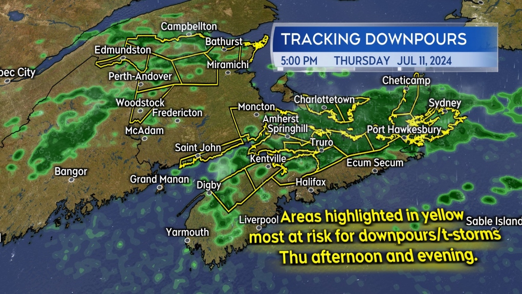 The highest risk areas for thunderstorms and downpours Thursday afternoon into evening.
The area of inclement weather has shown some radar indicated rain rates of 20 to 35 mm/hr. That is a heavy enough rain to bring about hazards such as reduced visibility, hydroplaning conditions, and flash flooding. Should multiple downpours move over the same location, localized rain totals could reach 50 to 100 mm.
Between 9 p.m. and 11 p.m. Thursday, the remaining downpours and thunderstorms are expected to be in the process of clearing to the east of Nova Scotia.
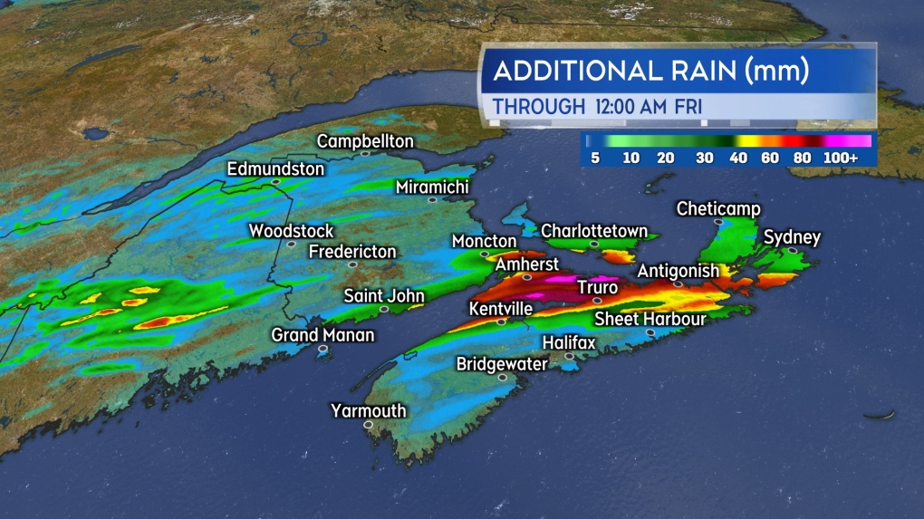 Localized rain amounts of 50 to 100 mm still being indicated as possible where repetitive downpours occur.
Initial rain reports
No finalized rain totals for the system are available yet as it continues to move through.
The initial band of heavier rain that came across central areas of New Brunswick and into western P.E.I., brought some Thursday morning reports in the range of 30 to 53 mm. A personal weather station in Fredericton has reported a total of near 70 mm just after noon on Thursday.
It will take until Friday morning to get a more concrete measurement of the rain amounts brought through by the system.
Heat and humidity follow for Friday and the weekend
Cloudy periods along with patchy showers, drizzle, and fog is expected Thursday overnight into early Friday morning.
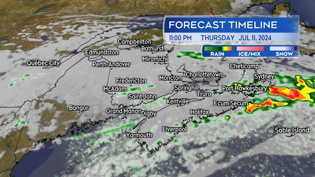 Downpours clearing east of the Maritimes late Thursday evening. Cloud, fog, showers and drizzle in behind.
The sun is expected to break through Friday afternoon with the exception of parts of the Bay of Fundy coastline in New Brunswick and the Atlantic coastline of Nova Scotia, which may be left with some marine cloud and fog. High temperatures will reach the mid-to-high 20s and with a high degree of humidity in the air, will feel well into the 30s.
It's heat and humidity in the weekend forecast. High temperatures for most communities in the high 20s and low 30s. A round of showers with a risk of thunderstorms will arrive for the Maritimes late Saturday afternoon and Saturday night. Back to a mix of sun and cloud and still hot for Sunday.
Shopping Trends
The Shopping Trends team is independent of the journalists at CTV News. We may earn a commission when you use our links to shop. Read about us.


CTVNews.ca Top Stories

Trudeau noncommittal on expanding rebate beyond 'working Canadians'
Prime Minister Justin Trudeau does not appear willing to budge on his plan to send a $250 rebate to 'hardworking Canadians,' despite pressure from the opposition to give the money to seniors and people who are not able to work.
'Mayday!': New details emerge after Boeing plane makes emergency landing at Mirabel airport
New details suggest that there were communication issues between the pilots of a charter flight and the control tower at Montreal's Mirabel airport when a Boeing 737 made an emergency landing on Wednesday.
Cucumbers sold in Ontario, other provinces recalled over possible salmonella contamination
A U.S. company is recalling cucumbers sold in Ontario and other Canadian provinces due to possible salmonella contamination.
Latest updates: Tracking RSV, influenza, COVID-19 in Canada
As the country heads into the worst time of year for respiratory infections, the Canadian respiratory virus surveillance report tracks how prevalent certain viruses are each week and how the trends are changing week to week.
Weekend weather: Parts of Canada could see up to 50 centimetres of snow, wind chills of -40
Winter is less than a month away, but parts of Canada are already projected to see winter-like weather.
W5 Investigates
W5 Investigates A 'ticking time bomb': Inside Syria's toughest prison holding accused high-ranking ISIS members
In the last of a three-part investigation, W5's Avery Haines was given rare access to a Syrian prison, where thousands of accused high-ranking ISIS members are being held.
Federal government posts $13B deficit in first half of the fiscal year
The Finance Department says the federal deficit was $13 billion between April and September.
Armed men in speedboats make off with women and children when a migrants' dinghy deflates off Libya
Armed men in two speedboats took off with women and children after a rubber dinghy carrying some 112 migrants seeking to cross the Mediterranean Sea started deflating off Libya's coast, a humanitarian aid group said Friday.
Nick Cannon says he's seeking help for narcissistic personality disorder
Nick Cannon has spoken out about his recent diagnosis of narcissistic personality disorder, saying 'I need help.'
Toronto
-

Black Friday sales stretch out for weeks: retail analyst
Black Friday is officially the busiest shopping day of the year, even surpassing Boxing Day and Super Saturday, the final Saturday before Christmas. Analysts say retailers are rolling out Black Friday sales sooner now, making them last longer into Cyber Monday and beyond.
-
Cucumbers sold in Ontario, other provinces recalled over possible salmonella contamination
A U.S. company is recalling cucumbers sold in Ontario and other Canadian provinces due to possible salmonella contamination.
-
House fire in North York sends 6 people to hospital
Six people are in hospital as a precaution after a fire broke out in a North York home overnight.
Calgary
-

Calgary Mayor Jyoti Gondek running for re-election
Calgary Mayor Jyoti Gondek has announced she will run for re-election in the next municipal election in 2025.
-
Multiple crashes reported on Deerfoot Trail
Calgary police say there are at least three major crashes on Deerfoot Trail on Friday morning as frigid overnight temperatures likely led to icy conditions in many areas.
-
Black Friday deals look to appeal to budget-friendly Calgary shoppers
Black Friday sales are in full swing as annual holiday shopping returns and Calgary retailers compete harder than ever to coax budget-conscious shoppers into a deal.
Edmonton
-

Pedestrian hospitalized after Friday morning crash in central Edmonton
A woman is in hospital with serious injuries after a crash on Friday morning.
-
Oilers rightly optimistic they can pull themselves into NHL playoff picture. Again
Hockey fans know the adage: U.S. Thanksgiving, while unofficial, serves as a great calendar marker in predicting which teams will make the National Hockey League playoffs.
-
'Fear and shame': Red Deer police issues warning of rising online sextortion incidents
Red Deer RCMP issued a warning to the public about the increase of sextortion incidents online.
Montreal
-

Quebec trying to 'minimize' impact of health care cuts on services
Eliminating $1.5 billion in health care spending is likely to have an impact on services, but Quebec says it will try to 'minimize' it.
-
One woman killed, one hurt in armed robbery attempt southeast of Quebec City
One woman was killed and another was badly injured following an alleged armed robbery attempt at a clothing store southeast of Quebec City.
-
'Mayday!': New details emerge after Boeing plane makes emergency landing at Mirabel airport
New details suggest that there were communication issues between the pilots of a charter flight and the control tower at Montreal's Mirabel airport when a Boeing 737 made an emergency landing on Wednesday.
Ottawa
-

Ottawa police charge two adults, teenager following Orleans kidnapping and robbery
The Ottawa Police Service says two adults and a teenager are facing multiple charges following a kidnapping, robbery and extortion incident that happened last month in Orleans.
-
'Dude, Where's My Bus?' Ottawa man fed up with OC Transpo makes documentary exploring transit troubles
Gio Petti put together a documentary on OC Transpo, asking how we got here. How did a city that was once lauded as an example of how to do transit right, and that boasted some of the highest per capita transit ridership numbers in the country, become a system that now elicits so much frustration from users?
-
Almonte business to deliver letters to Santa
As the Canada Post strike enters it's third week with no end in site, many Canadians are wondering if their Christmas wish lists will get to the North Pole this year.
London
-

Employees pepper sprayed at London business
Around 4 p.m. on Thursday, police were called to a report of an assault in progress at a business int he 600 block of Wilkins St. near Wellington Road.
-
Sarnia police lay charges after woman wakes up to naked man in her home
An arrest has been made after a break and enter call in Sarnia where a woman woke up to a naked man in her home. Police said after investigating, officers were able to identify a 26-year-old man who was also wanted on an outstanding warrant in London.
-
Knights' Boulton hit with eight-game suspension
The left winger has been suspended eight games, retroactive to Nov. 23 against Saginaw, when he was handed a major penalty for slashing, along with a game misconduct.
Barrie
-

50 cms of snow across central Ontario expected this weekend
Environment Canada has released snow squall warnings and watches for our region.
-
Alleged mastermind behind Ontario woman's presumed death seeks bail
The man facing first-degree murder and kidnapping charges in the disappearance of Ontario woman Elnaz Hajtamiri took another shot at bail on Friday in a Barrie courtroom. Mohamad Lilo, 37, has been behind bars since his arrest more than two years ago.
-
Ontario offers municipalities $77M to offset skyrocketing OPP costs
The Ontario government is offering $77 million to help municipalities that rely on provincial police deal with skyrocketing law enforcement costs.
Northern Ontario
-

Another 60 cm of snow possible in the Sault as severe weather continues
Closures and cancellations are piling up in Sault Ste. Marie as a major winter storm continues for another day Friday.
-
California man who went missing for 25 years found after sister sees his picture in the news
It’s a Thanksgiving miracle for one California family after a man who went missing in 1999 was found 25 years later when his sister saw a photo of him in an online article, authorities said.
-
Two arrested following shooting on Manitoulin Island
The Manitoulin detachment of the Ontario Provincial Police have two people in custody following a shooting incident in Wikwemikong Unceded Territory on Thursday.
Kitchener
-

Erick Buhr to represent himself during sentencing for second-degree murder in death of his grandmother, Viola Erb
Erick Buhr will represent himself as he prepares for sentencing after being convicted of second-degree murder in the death of his grandmother, Viola Erb.
-
One dead, another hurt in Cambridge shooting
Waterloo Regional Police are investigating a fatal shooting in Cambridge.
-
Police looking for missing teen last seen in Cambridge
Waterloo Regional Police are looking for information about the whereabouts of a missing teen.
Windsor
-
 Breaking
Breaking Guilty on all counts: Windsor man convicted of careless driving in Retrofest double fatal collision
The Windsor man charged in connection to the double fatal Retrofest collision has been convicted on all counts.
-
$4,000 in products reported stolen from storage container
Chatham-Kent police are looking for suspects after $4,000 in products were stolen from a storage container in Chatham.
-
Bright Lights Windsor kicks off with official tree lighting
Bright Lights Windsor is back with the official tree lighting on Friday night.
Winnipeg
-

IIU looking for witness of fatal officer-involved shooting
Manitoba's police watchdog is looking for a person they say witnessed an officer-involved shooting that killed one person.
-
Water main break causing Friday morning traffic delays in Winnipeg
Winnipeg drivers are being warned of traffic delays on Friday morning due to a water main break.
-
A tale of two downtowns: Restaurants opening and closing show complexity of downtown revival
Proposed developments and new businesses opening are fueling optimism for some on a revival of downtown Winnipeg, but some business owners say the present remains problematic.
Regina
-

Fundraising campaign at Regina school ends with an alpaca kiss
Students, staff and family members of Imperial Community School gathered to celebrate a successful fundraising campaign for United Way Regina.
-
Trudeau noncommittal on expanding rebate beyond 'working Canadians'
Prime Minister Justin Trudeau does not appear willing to budge on his plan to send a $250 rebate to 'hardworking Canadians,' despite pressure from the opposition to give the money to seniors and people who are not able to work.
-
Crown gives final remarks in Ruben Manz case as argument to jury concludes
The prosecution has presented their closing remarks against Ruben Manz to a 13-person jury, bringing an end to arguments before their sequestering.
Saskatoon
-

'Due to the temperatures, we are concerned': RCMP seek tips finding missing elderly man
Saskatchewan RCMP are asking property owners in the rural area in the RM of Laird to check farm outbuildings or sheds in their area for a missing 60-year-old man.
-
Ontario men arrested after Saskatoon police seize 16 kilos of meth, nearly $70K in cash
Saskatoon police say officers arrested three 20-year-old men Wednesday afternoon and seized nearly $70,000, in cash as well as various illicit drugs.
-
Extreme cold warning issued for Saskatoon
Environment Canada has issued an extreme cold warning for parts of central Saskatchewan, including Saskatoon, on Thursday.
Vancouver
-

Man facing 10 charges after Richmond, B.C., crime spree
A Metro Vancouver man has been charged with nine counts of breaking and entering and one count of mischief after a five-day crime spree last November.
-
Free skating rink at Robson Square opens for winter
The free skating rink in downtown Vancouver officially opened for the season Friday.
-
Winter storm watch issued as snow, heavy rain expected for B.C. coast
A winter storm is moving over British Columbia's coast, bringing strong winds, heavy snow and freezing rain as snowfall warnings continue for much of the province's Interior.
Vancouver Island
-

Winter storm watch issued as snow, heavy rain expected for B.C. coast
A winter storm is moving over British Columbia's coast, bringing strong winds, heavy snow and freezing rain as snowfall warnings continue for much of the province's Interior.
-
Police renew appeal for information 12 years after Victoria woman's disappearance
On the anniversary of her disappearance, police in Victoria renewed their appeal for information in Emma Fillipoff’s 12-year-old missing persons case.
-
Man facing 10 charges after Richmond, B.C., crime spree
A Metro Vancouver man has been charged with nine counts of breaking and entering and one count of mischief after a five-day crime spree last November.
Kelowna
-

Kelowna, B.C., to host the Memorial Cup in the spring of 2026
The Western Hockey League's Kelowna Rockets will host the Memorial Cup in the spring of 2026, the Canadian Hockey League said Wednesday.
-
545 vehicles impounded in 332 days: BC Highway Patrol pleads for drivers to slow down
Mounties with the BC Highway Patrol in Kelowna say they've impounded more than 545 vehicles for excessive speed and aggressive driving so far this year. That works out to more than 1.6 per day.
-
Man in hospital following targeted shooting in Kamloops
Police are appealing for information on a targeted shooting that resulted in the hospitalization of a man in Kamloops.


