Frost advisories in effect across New Brunswick
Fair weather is expected in the Maritimes for the first week of October. However, brisk nights may result in frost on the ground. Rain or showers are unlikely until the weekend.
Frost advisories
Frost advisories have been issued for much of New Brunswick.
Low temperatures Tuesday night are expected to fall into a range of 0 to 4 degrees. Combined with a light wind and relatively clear sky, patchy frost is likely to develop.
Environment Canada is recommending that residents “cover up plants, especially those in frost-prone areas.”
Tuesday night into Wednesday morning is expected to be the coolest period of the week. Frost is common this time of the year and frost advisories are issued until the close of the growing season.
 Frost advisories were in effect for much of New Brunswick on Oct. 1, 2024.
Frost advisories are in effect across New Brunswick.
Dry September
Much of the Maritime region finished well below 30-year averages for rain this past September.
Northern and central New Brunswick, Prince Edward Island, and parts of eastern Nova Scotia were among the driest areas.
Even for those areas that saw monthly totals closer to average, it should be noted that the bulk of that rain came on essentially two days – Sept. 7 and Sept. 27.
Much of this first week of October is expected to be dry as well. A weather front from the west may bring widespread rain and showers Saturday. A stronger low-pressure system with further periods of rain is expected early next week.
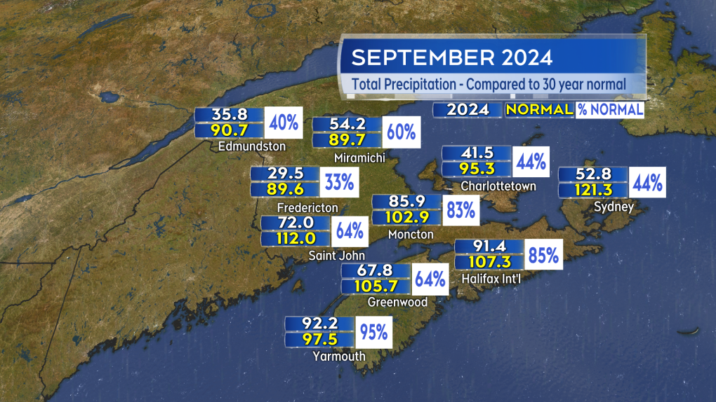 It was a very dry month of September for most of the Maritimes. Significant rain fell only two days during the month.
It was a very dry month of September for most of the Maritimes. Significant rain fell only two days during the month.
Tropical Storm Kirk
As the U.S. continues to recover from the devastation of Hurricane Helene, another major hurricane is forecast to develop in the Atlantic.
Tropical Storm Kirk is currently situated in the middle of the Atlantic and is forecast to become a major Category 3 hurricane as it turns northward.
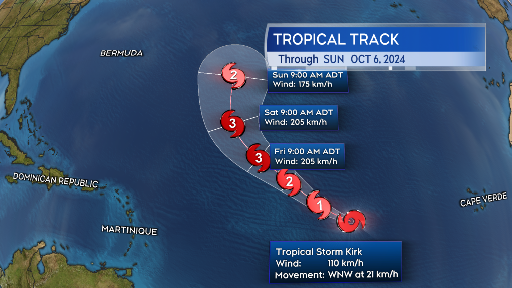 The forecast strengthening and movement of Tropical Storm Kirk over the next five days.
The forecast strengthening and movement of Tropical Storm Kirk over the next five days.
Fortunately, Kirk is starting its north and east turn well to the east of Bermuda. That greatly diminishes any chance of the storm having a direct weather impact on North America, including Atlantic Canada. Storms that start a northward turn closer to, or west of, Bermuda are typically the ones that pose a greater threat to Atlantic Canada.
There is a second area off the coast of Africa that is likely to develop into Tropical Storm Leslie over the next few days. Right now that storm, like Kirk, is also likely to turn north and east while in the middle of the Atlantic.


CTVNews.ca Top Stories

Walking pneumonia is surging in Canada. Is it peaking now?
CTVNews.ca spoke with various medical experts to find out the latest situation with the typically mild walking pneumonia in their area and whether parents should be worried.
Minister calls GST holiday, $250 cheques for 18 million Canadians 'a targeted approach'
Women and Gender Equality and Youth Minister Marci Ien is calling the federal government's proposed GST holiday and $250 rebate cheques a 'targeted approach' to address affordability concerns.
'Her shoe got sucked into the escalator': Toronto family warns of potential risk of wearing Crocs
A Toronto family is speaking out after their 10-year-old daughter's Crocs got stuck in an escalator, ripping the entire toe area of the clog off.
Ancient meets modern as a new subway in Greece showcases archeological treasures
Greece's second largest city, Thessaloniki, is getting a brand new subway system that will showcase archeological discoveries made during construction that held up the project for decades.
Quebec man, 81, gets prison sentence after admitting to killing wife with Alzheimer's disease
An 81-year-old Quebec man has been sentenced to prison after admitting to killing his wife with Alzheimer's disease.
Canada Post quarterly loss tops $300M as strike hits second week -- and rivals step in
Canada Post saw hundreds of millions of dollars drain out of its coffers last quarter, due largely to its dwindling share of the parcels market, while an ongoing strike continues to batter its bottom line.
'Immoral depravity': Two men convicted in case of frozen migrant family in Manitoba
A jury has found two men guilty on human smuggling charges in a case where a family from India froze to death in Manitoba while trying to walk across the Canada-U.S. border.
Prime Minister Trudeau attends Taylor Swift's Eras Tour in Toronto with family
Prime Minister Justin Trudeau is a Swiftie. His office confirmed to CTV News Toronto that he and members of his family are attending the penultimate show of Taylor Swift's 'The Eras Tour' in Toronto on Friday evening.
Trump supporters review-bomb B.C. floral shop by accident
A small business owner from B.C.'s Fraser Valley is speaking out after being review-bombed by confused supporters of U.S. president-elect Donald Trump this week.
Shopping Trends
The Shopping Trends team is independent of the journalists at CTV News. We may earn a commission when you use our links to shop. Read about us.


Toronto
-

Man charged with murder in stabbing death of father in Scarborough
A 32-year-old man has been charged with murder in connection with the stabbing death of his father in Scarborough on Wednesday.
-
Prime Minister Trudeau attends Taylor Swift's Eras Tour in Toronto with family
Prime Minister Justin Trudeau is a Swiftie. His office confirmed to CTV News Toronto that he and members of his family are attending the penultimate show of Taylor Swift's 'The Eras Tour' in Toronto on Friday evening.
-
3 charged in connection with collision between TTC bus and stolen BMW that injured 9
Three people are facing charges in connection with a carjacking of a stolen BMW that collided with a TTC bus in North York early Monday morning.
Calgary
-

'Sounded like a bomb': Mahogany residents stunned by townhouse explosion, fire
Investigators are working to piece together what caused an explosion and fire at a six-plex in the southeast Calgary community of Mahogany.
-
Budget adjustments passed by Calgary city council; property taxes to go up 3.6 per cent in 2025
Calgary city council passed its mid-cycle budget adjustments on Friday evening, following a long week of debate. The budget was passed with a vote of 9-6.
-
‘Pinch me I’m dreaming:’ Calgary drummer pulled from crowd to play with the Arkells
For young musicians, to be up on stage in front of thousands of people, would be a dream come true. That’s exactly what happened to a Calgary girl, after being invited to play with Canadian rock icons The Arkells.
Edmonton
-

Man armed with knife arrested in west Edmonton: EPS
A man armed with a knife was arrested in west Edmonton Friday afternoon, police said.
-
Santas, sports and shows: Here's what's happening in Edmonton this weekend
If you want to get out and enjoy the weather, or get inside and warm up, there's plenty to do in and around Edmonton this weekend.
-
Drake's clothing brand launches NHL collection including Oilers merch
Drake's October's Very Own (OVO) clothing has launched an NHL collection.
Montreal
-

3 arrested at pro-Palestinian, anti-NATO protest downtown Montreal
As NATO officials met up in Montreal, pro-Palestinian protesters flooded downtown in solidarity with those in Gaza.
-
Quebec man, 81, gets prison sentence after admitting to killing wife with Alzheimer's disease
An 81-year-old Quebec man has been sentenced to prison after admitting to killing his wife with Alzheimer's disease.
-
Montreal family doctor admits to fathering child with 19-year-old patient
A Montreal family doctor has vowed to stop practicing medicine after he admitted to fathering a child with a 19-year-old woman who was his patient.
Ottawa
-
 NEW THIS MORNING
NEW THIS MORNING 290,000 speeding tickets and counting: A look at how many photo radar tickets have been issued in Ottawa in 2024
Photo radar cameras have caught nearly 300,000 speeders on Ottawa roads so far this year, as the City of Ottawa prepares to expand the automated speed enforcement camera program to another 39 locations over the next 14 months.
-
Seniors facing 60% hike for OC Transpo monthly transit pass in 2025 under new proposal
Ottawa seniors will be facing a 60 per cent hike in transit fares in 2025, instead of a 120 per cent increase, under a new plan to halve a proposed hike in fares for riders over the age of 65.
-
Ottawa Food Bank declares an emergency amid record-breaking usage
The Ottawa Food Bank is calling the record-breaking visits to its food programs "a declaration of emergency," with children and youth and newcomers accounting for more than a quarter of visits last year.
London
-

Wingham area raises $3.6 million for new CT scanner
Wingham will be getting its first ever CT Scanner thanks to a multimillion dollar fundraising campaign that just came to a close.
-
Next week’s weather will put the 'brr' in November
We’re off to a damp start this weekend, “Cloudy conditions to kick off your Saturday with the chance of rainfall first thing in the morning [due to] lake effect showers,” said CTV London Meteorologist Julie Atchison. “Over the next 36 hours we will see the chance for showers lingering.”
-
Knights win dramatic Friday night comeback
The London Knights extended their winning streak to 13 games Friday night with a dramatic comeback win over the Owen Sound Attack at Canada Life Place.
Barrie
-

Highway 400 closed in Muskoka Lakes after fatal propane truck rollover
Emergency crews were called to Highway 400 in Georgian Bay Township Friday morning after a fatal tanker truck rollover.
-
Drug trafficking investigation results in largest fentanyl seizure in Simcoe County: OPP
Two people are facing drug trafficking charges after what provincial police are calling the largest fentanyl seizure in Simcoe County.
-
Barrie magic mushroom dispensary closed after company announces its shuttering Ont. locations
The doors are locked and the OPEN sign is off on Friday at an illegal magic mushroom dispensary in downtown Barrie one day after FunGuyz announced it would shutter its 30 Ontario locations.
Northern Ontario
-

Senior killed in dog attack in northern Ont.
An 81-year-old was killed in a dog attack this week in Bonfield, Ont. Police believe three dogs were involved.
-
Woman stabbed multiple times in Sudbury altercation
A 30-year-old woman is in hospital in Sudbury after she was stabbed multiple times early Friday morning in Chelmsford.
-
Police investigating death in Magnetawan, Ont.
The Almaguin Highlands detachment of the Ontario Provincial Police is investigating a sudden death in Magnetawan.
Kitchener
-

Advocates push for anti-renoviction bylaws as Waterloo Region reports affordable housing progress
On National Housing Day, housing advocacy group ACORN continued to push for anti-renoviction bylaws.
-
Man charged in Kitchener crash involving Grand River Transit LRT
Charges were laid after a crash between an LRT train and a Dodge vehicle shut down a busy Kitchener street for more than eight hours on Thursday.
-
How University of Waterloo researchers could help charge your devices by moving your body
Imagine being able to charge your devices through your body’s movements.
Windsor
-

Truck fire on the Ambassador Bridge
Windsor fire responded to a transport truck fire on Friday afternoon on the Ambassador Bridge.
-
4 Windsor, Chatham-Kent councillors oppose use of notwithstanding clause on encampments
Four councillors from Windsor and Chatham-Kent are among 72 municipal leaders opposing a letter from 15 Ontario mayors that supports Premier Doug Ford's push to use the notwithstanding clause to clear homeless encampments.
-
Concerns over people attempting to cross Detroit River illegally
Windsor Port Authority’s harbour master is raising concern about the number of people attempting to cross the Detroit River illegally following the most recent U.S. presidential election.
Winnipeg
-

Semi leaves Winnipeg overpass, hits train, causes derailment
Winnipeg police are responding to a train derailment and semi collision that has closed the Perimeter Highway and a section of Fermor Avenue Friday afternoon.
-
Manitoba reports first case of mpox, province says risk to public is low
The Manitoba government is reporting the first confirmed case of mpox in the province, noting it is also a strain that has not been seen in Canada before.
-
Towing company sues Winnipeg councillor, other towing company for defamation
A Winnipeg towing company is suing a Winnipeg city councillor and another local towing company, claiming comments they made about contracts in the city have defamed them.
Regina
-

Ministry of Highways releases annual snow campaign as Sask. braces for more snow
Snowplows will be on standby ready to go as the province is expected to get more snow over the weekend.
-
Chiropractor accused of sexually assaulting 7 women denies all allegations as part of second day of testimony
Ruben Manz, a Regina-based chiropractor accused of sexually assaulting seven women from 2010 through 2021, denied ever touching any of the alleged victims in a sexual nature while under oath.
-
Here's a look inside the Globe Theatre before it reopens
The format is the same, but the venue looks very different from the last time audiences were inside Regina's Globe Theatre after extensive renovations.
Saskatoon
-

Why isn't Saskatoon's new downtown shelter open yet?
Saskatoon's new downtown shelter must undergo renovations before it can open, according to the operator of the site.
-
Sask. principal has sexual assault conviction overturned in light of 'butt-grabbing game'
A Saskatchewan principal sentenced to six months behind bars for sexual assault has another chance to prove he’s the victim of a middle-school prank that escalated out of control.
-
Prince Albert food bank faces soaring demand
The Prince Albert Food Bank is grappling with a significant surge in demand, with the number of hampers doubling since 2017.
Vancouver
-

SPS one week away from taking over Surrey policing
It’s been a long and drawn out process, but we are now a week away from Surrey’s new municipal force formally taking over policing responsibility in that city.
-
Abbotsford residents fed up with noise from provincial project so loud it 'shakes the house'
Residents of a rural Abbotsford neighbourhood are fed up with the noise from a provincial project that has meant hundreds of dump trucks rumbling up and down their street in the middle of the night.
-
Jodi Henrickson’s ex-boyfriend Gavin Arnott charged with assaulting woman in Alta.
The ex-boyfriend of missing B.C. teenager Jodi Henrickson was recently charged with assaulting a woman in Alberta, but the charges were withdrawn due to an unco-operative witness, CTV News has learned.
Vancouver Island
-

Victoria police face being understaffed amid proposed budget cuts
Layoffs could be imminent for the Victoria Police Department if it adheres to the requests of the City of Victoria, and cuts over $2 million from its budget.
-
Campbell River high school closure extended due to fire
Carihi Secondary school in Campbell River is closed due to a fire on the property overnight – drawing a firefighting response from multiple departments and a crowd of onlookers.
-
Grey Cup streaker fined $10K, banned from BC Place
The woman who ran across the field wearing nothing but her shoes at last weekend’s Grey Cup has been given a fine and banned from BC Place.
Kelowna
-

Man in hospital following targeted shooting in Kamloops
Police are appealing for information on a targeted shooting that resulted in the hospitalization of a man in Kamloops.
-
Police cleared of fault in fatal 2023 crash in B.C.'s Interior
British Columbia's independent police watchdog has cleared officers of wrongdoing in a crash where three people were killed south of Kamloops in July of last year.
-
B.C. woman sentenced for stealing $14K in funds raised for schoolkids
A B.C. woman who stole more than $14,000 in volunteer-raised funds that were supposed to be spent on school supplies and programs – including hot meals for vulnerable kids – won't spend any time in jail.


