Hurricane Earl east of N.L. but brings powerful gusts to Avalon Peninsula
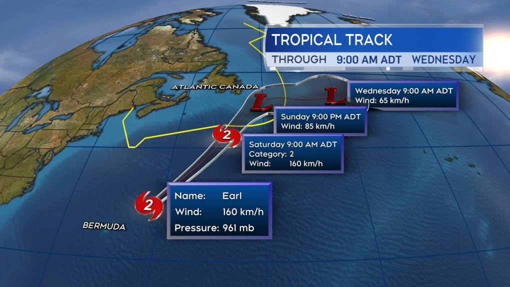
 The forecast from the National Hurricane Center continues to hold Earl well the east of the land areas of the Maritimes. Some increase in coastal swell and currents is expected this weekend.
Environment Canada has posted a wind warning for the Avalon Peninsula as post-tropical storm Earl is expected to pass east of Newfoundland.
The forecaster says the storm is decelerating and expected to largely stay off the shores of eastern Newfoundland, but the agency says the Avalon Peninsula is still forecast to see strong winds.
The wind warning is in effect for the southern Avalon Peninsula and St. John's and vicinity, with gusts potentially reaching 110 kilometres per hour over exposed areas.
Rain is expected to be heavy at times and Environment Canada predicts it may cause road shoulder erosion, localized flooding and hazardous driving conditions.
Forecasts predict rainfall rates could be as high as 10 to 20 millimetres per hour, with total rainfall amounts of 50 to 90 millimetres expected.
Ocean swells from Earl will continue on Sunday along the coasts of Nova Scotia and Newfoundland, creating higher than normal water levels and large waves.
In addition, hurricane force winds will affect the southern Grand Banks on Saturday night, weakening to gale force by Sunday morning.
This report by The Canadian Press was first published Sept. 10, 2022.
CTVNews.ca Top Stories

B.C. teen with Canada's first human case of avian flu in critical condition, Dr. Bonnie Henry says
The teenager who is sick with the first-ever human case of avian influenza acquired in Canada is in hospital in critical condition, provincial health officer Dr. Bonnie Henry said Tuesday.
Here's why thieves may be stealing butter in Canada
The case of the missing butter remains a mystery, but some have ideas on what's behind the unusual crimes.
Former B.C. premier John Horgan dies at 65
Former B.C. premier John Horgan, a popular leader renowned for his affable personality and dedicated public service, has died
Body found in Montreal park identified as cryptocurrency influencer
The body of a man that was found in a park in the Ahunstic-Cartierville borough last month has been identified as cryptocurrency influencer Kevin Mirshahi.
Alleged serial killer previously pled guilty to 2018 attack on Waterloo, Ont. bus
The woman accused of killing three people in three days in three Ontario cities also previously admitted to attacking strangers on buses in the Region of Waterloo.
Air Canada to add new routes to U.S., Europe and North Africa in summer 2025
Getting to destinations in the U.S., Europe and North Africa is about to get easier, as Air Canada announced it will be increasing flights to a number of new destinations this summer.
History in Halifax is slowly being wiped off the map: study
Saint Mary's University archeologist Jonathan Fowler is sounding an alarm with a new study. According to Fowler, the centuries-old architecture that adds to Halifax’s heritage and historic vibe is slowly being wiped away as the city grows.
2-year-old gorilla 'Eyare' dies unexpectedly at Calgary Zoo
A young gorilla at the Calgary Zoo has died. The Wilder Institute/Calgary Zoo announced a member of its western lowland gorilla troop passed away unexpectedly, in a news release Tuesday.
Quebec officer suspended 15 days for throwing away piece of victim's skull
A Quebec provincial police officer has been suspended for 15 days without pay after throwing part of a young motorcycle accident victim's skull into a ravine in 2021.


