
HALIFAX -- A strong low-pressure system will move northward out of the southeastern United States Thursday. On Friday, that low will then move up through the Bay of Fundy and into the southwestern corner of Newfoundland.
Ahead of, during, and in the wake of the storm’s passage, there will be widespread impacts from snow, ice pellets, freezing rain, and rain for the region.
Snow will begin as early as Thursday morning for the southwest of Nova Scotia and New Brunswick. By early afternoon snow will have spread across much of the Maritimes. This initial snow will be light, but will accumulate a few to several centimetres by mid-evening Thursday, creating greasy roads.
Overnight into Friday morning, the snow will turn to freezing rain for much of Nova Scotia, and a mix of snow, ice pellets, and freezing rain for P.E.I. and southern New Brunswick. Snow, heavy at times, will fall for central and northern New Brunswick.
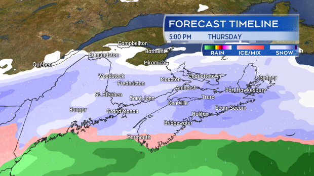
Snow develops across the Maritimes on Thursday, creating greasy roads in the afternoon and evening.
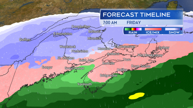
The most inclement weather arrives for and is ongoing through Friday. Heavier snow, freezing rain, and rain all in the forecast.
The heaviest snow, 20 to 40 cm, looks likely to accumulate along and north of a line from McAdam, N.B. to Summerside, P.E.I. Just south of that line, a heavy mix of snow, ice pellets, and freezing rain will produce accumulations ranging from 10 to 20 cm. Much of Nova Scotia will be at risk of prolonged periods of freezing rain on Friday. Finally, the Atlantic coastline of Nova Scotia and into the Tri-Counties (Shelburne, Yarmouth, Digby) will turn to heavy rain with totals ranging from 25 to 50 mm. Areas that experience that heavy rainfall should watch for localized flooding as the ground is frozen, increasing runoff.
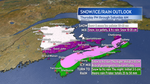
Impacts will be varied across the Maritimes, ranging from heavy snow in northern/central N.B., to heavy rain on the Atlantic coastline of N.S. Lots of freezing rain and ice pellets in between.
Wind will be a factor as well. Since the storm track comes straight up the Bay of Fundy on Friday, the strongest winds will be from the southeast for N.S., and east/northeast for P.E.I. and N.B. Peak gusts for Nova Scotia will occur Friday evening and night, ranging from 60 to 90 km/h. Gusts up to 130 km/h will be possible for northern Inverness County, Cape Breton, due to the topography of the Highlands. Peak gusts for P.E.I. and N.B. during that time of 30 to 60 km/h.
In the wake of the storm on Saturday morning, west/northwest winds will gust 50 to 80 km/h, with the strongest gusts for P.E.I. and eastern areas of Nova Scotia. Those areas will need to be aware that blowing snow and a risk of snow squalls will extend through Saturday morning. Wind will continue to diminish Saturday evening and night.
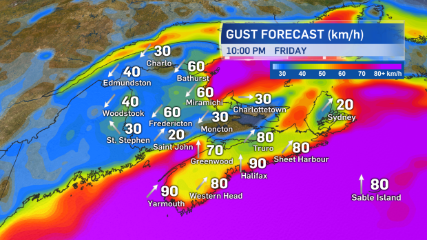
Winds will strengthen through Friday to hit peak gusts in the evening and night. Strong northwest gusts will follow in the wake of the storm Saturday, particularly for P.E.I. and eastern N.S.
Special weather statements have been issued for all three Maritimes provinces. Weather warnings look very likely, so please check in on your forecast and any issued alerts over the next few days.
Takeaways:
- Snow develops Thursday. Roads will turn greasy in the afternoon and evening.
- Weather conditions will deteriorate Thursday night and Friday morning.
- Heavy snow, freezing rain, and rain will be ongoing for much of Friday, with winds getting stronger into the evening and night.
- Lingering impacts on Saturday may include strong northwest winds and a risk of snow squalls for P.E.I. and eastern N.S.


