Kalin’s Call: More communities under heat warnings; hot weather will extend into weekend

Additional areas of New Brunswick and Prince Edward Island were placed under heat warnings by Environment Canada on Thursday.
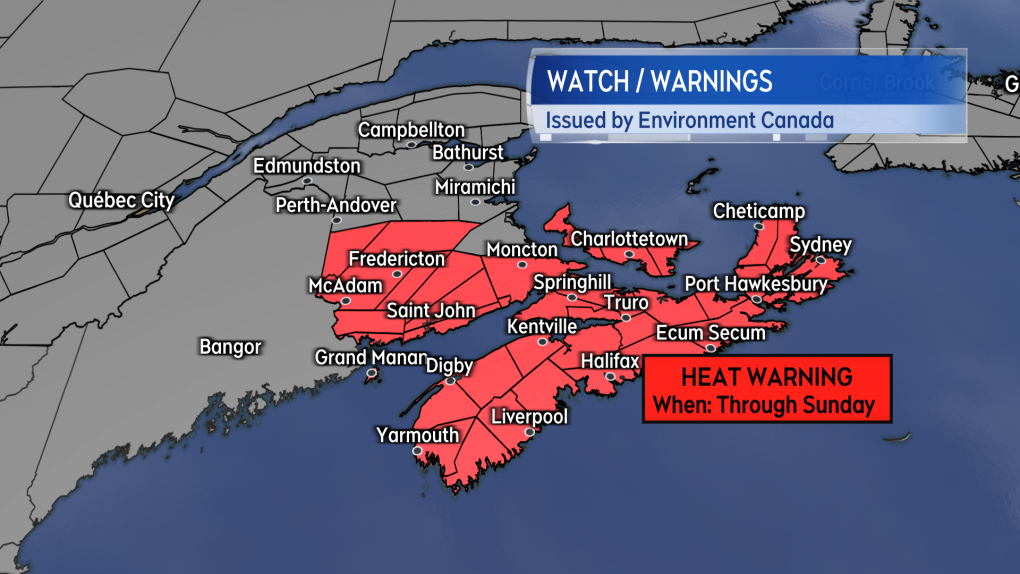 Heat Warnings continue and were expanded for parts of the Maritimes on Thursday.
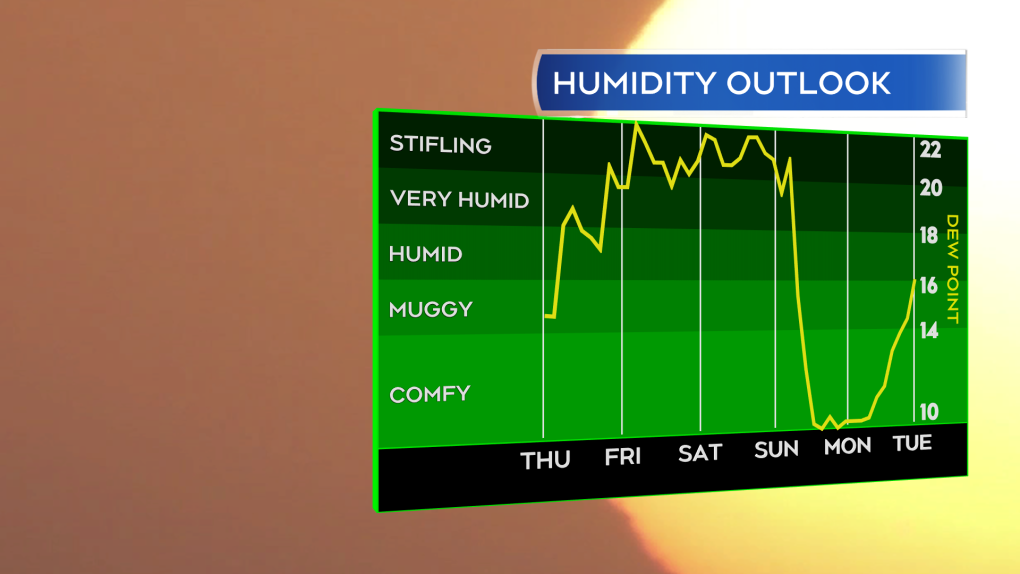
The hot and humid weather will extend through the weekend. Daytime high temperatures for most communities can expect to be in the high 20s and low 30s with the humidex – what it feels like – rising into a range of 35 to 40 degrees. Overnight low temperatures aren’t expected to cool much lower than the high teens, limiting the amount of night time relief. A period of showers and rain during the Monday to Tuesday timeframe of next week is expected to lower temperature and the humidex, breaking the heat across the entirety of the Maritimes.
Between Thursday and then, more moderate temperatures can be found on parts of the coast. There is expected to be a prevailing southwest wind Friday and the weekend, which will keep an onshore wind on coastal areas of the Bay of Fundy coastline and the Atlantic coastline of Nova Scotia. There may be some marine cloud/fog present at times for those areas as well. Northern areas of New Brunswick will have some slightly drier air move, preventing the humidex from rising as high as other parts of the region and are not currently under the heat warning.
 Hot and humid weather is expected to continue through the weekend with a round of showers and rain breaking the heat early next week.
Stay hydrated and take breaks to cool down and watch for signs of heat exhaustion and heat stroke. Check in on those who are more vulnerable in these type of conditions and who don’t readily have access to the means to cool down. If in a residence without air conditioning, it is often best to keep windows and blinds closed during the day and then open during the night as temperatures fall. Reducing the use of appliances that generate heat, such as an oven, is also a good idea.
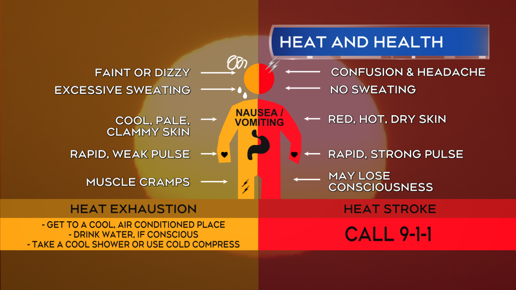 Watch for signs of heat exhaustion and heat stroke. Heat stroke is a medical emergency and requires immediate action.
Often with building heat and humidity comes a risk of thunderstorms. The risk of thunderstorms will be highest ahead of a weather front that moves in from Quebec on Thursday and Friday. For Thursday there is a risk of isolated thunderstorms in northern New Brunswick during the afternoon and evening. On Friday, the risk of isolated thunderstorms shifts to southern New Brunswick, Prince Edward Island, and Nova Scotia. Like with much of the region’s summer time showers and thunderstorms, these are expected to be very hit-and-miss by nature. The most likely hazards with any occurring thunderstorms will be lightning and downpours.
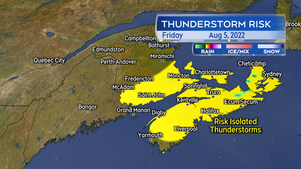 Isolated thunderstorms are possible Thursday afternoon and evening in northern New Brunswick. The risk of thunderstorms shifts to southern New Brunswick, Prince Edward Island, and Nova Scotia for Friday.


CTVNews.ca Top Stories

LIVE UPDATES
LIVE UPDATES Critical infrastructure 'successfully protected': Jasper park officials
Jasper National Park officials in an update said all critical infrastructure in the townsite has been 'successfully protected, including the hospital, emergency services building, both elementary and junior/senior schools, activity centre and wastewater treatment plant.'
Canadian Olympic Committee removes women's soccer team's head coach over drone scandal
The Canadian Olympic Committee has removed women's national soccer team head coach Bev Priestman over a drone scandal, according to a press release from the organization.
'I was just shocked': Jasper lodge owner on seeing property destroyed by wildfire
On Wednesday night, the owner of Maligne Lodge in Jasper, Alta., was shocked to receive a photo of her business engulfed in flames.
Prince William's 2023 salary revealed in new report
Newly released financial reports show that William, the Prince of Wales, drew a salary of $42.1 million last fiscal year, his first since inheriting the vast and lucrative Duchy of Cornwall.
Yukon woman narrowly escapes bear attack, credits hair clip
A woman in Yukon believes her hair clip helped save her during a bear attack.
P.E.I. and New Brunswick among most overworked provinces in Canada, study finds
A study says Prince Edward Island is the second most overworked province in Canada based on average weekly hours worked, while New Brunswick falls in third.
Mary-Ellen Turpel-Lafond likely has Indigenous DNA: report
The Law Society of British Columbia says a DNA test shows a former judge and Order of Canada recipient accused of falsely claiming to be Cree "most likely" has Indigenous heritage.
Alberta premier says a third, perhaps half, of all Jasper buildings destroyed by fire
Alberta Premier Danielle Smith says early reports indicate a third and perhaps up to half of all buildings in the historic Rocky Mountain resort town of Jasper have burned in a wildfire.
OPINION
OPINION Prince Harry: Press intrusion and the family rift explored in new doc
Prince Harry, the Duke of Sussex, has once again found himself at the centre of media attention following his recent interview as part of 'Tabloids on Trial,' an ITV documentary on phone hacking and tabloid intrusion.
Shopping Trends
The Shopping Trends team is independent of the journalists at CTV News. We may earn a commission when you use our links to shop. Read about us.


Toronto
-

Police identify man and woman killed in quadruple shooting in Toronto
Toronto police have now identified the two victims killed in a quadruple shooting in Scarborough, Ont. early Wednesday morning.
-
Man critically injured in 3-vehicle collision in Etobicoke
A man has been critically injured in a three-vehicle collision in north Etobicoke.
-
New details emerge in wrong-way crash on Hwy. 401 that killed baby and grandparents
Durham Regional Police have confirmed new details about a deadly wrong-way crash on Highway 401 which claimed the lives of a baby and his grandparents following a police chase in April.
Calgary
-

Calgary reception centre to remain open for 48 hours to support wildfire evacuees
Calgary Mayor Jyoti Gondek says the city's reception centre for Jasper wildfire evacuees will remain open for the next 48 hours.
-
Calgary events cancelled, altered amid air quality advisory
An air quality advisory was issued for Calgary Thursday, as wildfire smoke engulfed the city.
-
'Co-ordinated effort': Ottawa and Alberta help each other with massive firefights
The Jasper wildfire has started a new conversation around Canada's large-scale catastrophe readiness, and the way limited resources are dispersed in case of emergency.
Edmonton
-
LIVE UPDATES
LIVE UPDATES Critical infrastructure 'successfully protected': Jasper park officials
Jasper National Park officials in an update said all critical infrastructure in the townsite has been 'successfully protected, including the hospital, emergency services building, both elementary and junior/senior schools, activity centre and wastewater treatment plant.'
-
Jasper Park Lodge reports most structures 'standing and intact' amid wildfire
The Fairmont Jasper Park Lodge said Thursday afternoon most of its structures are "standing and intact," including its iconic main lodge.
-
'Holy s***': Jasper couple remembers ash falling like rain during escape from wildfire
A long-time Jasper business owner said this summer was his best yet — until his family was forced to close up, pack up and flee the raging wildfire that tore through the town Wednesday.
Montreal
-

3 tornadoes confirmed as truck toppled, trees uprooted south of Montreal
A tornado overturned a truck and uprooted several trees in Brossard on Montreal's South Shore.
-
Laurentians municipality mulls banning wakesurfing
Public consultations have been launched on a draft bylaw in Saint-Adolphe-d'Howard that would prohibit wake boats from Lac Saint-Joseph and neighbouring Lac Sainte-Marie.
-
Persistent flooding angers Town of Mount Royal residents
In the Town of Mount Royal (TMR), several households have been suffering from persistent flooding following torrential downpours.
Ottawa
-

Hwy. 417 is closed until Monday for Preston Street bridge replacement. Here's what you need to know
A stretch of Highway 417 through Ottawa is now closed for the replacement of the aging Preston Street overpass. CTVNewsOttawa.ca looks at what you need to know about the Queensway closure for the replacement of the Preston Street bridge.
-
Youth receiving support from Children's Aid Society of Ottawa dies
The Children's Aid Society of Ottawa (CASO) and striking workers with the Ontario Public Service Employees Union (OPSEU) say a youth who was receiving support from the agency has died.
-
Ottawa residents grief-stricken for families fleeing Jasper, Alta. wildfire
Many people across the country, including in Ottawa, have connections to the popular town of Jasper, Alta., a vacation destination. Some, with family members who evacuated, are watching anxiously from afar.
London
-
Crash kills motorcyclist in Zorra Township
Oxford County OPP attended the scene of a fatal collision in Zorra Township Thursday.
-
Poilievre takes on crime, drugs, word terminology, and the media in London, Ont.
Federal Conservative leader Pierre Poilievre's tour through London Thursday focussed on justice and outrage over safe supply, and the term 'safe supply' itself.
-
25-year-old Londoner faces human trafficking charges
A man is now facing a wide swath of charges following an investigation by London Police Services Human Trafficking Unit. Beginning in April 2019, a woman entered an agreement with a man, employed as a sex worker.
Barrie
-

Ont. mayor fires back at 'misinformation' about people defecating on beach
Wasaga Beach's mayor is firing back at unverified claims circulating on social media that people are defecating in the sand at the provincial park.
-
Loose wheel hits 4 vehicles on Highway 400 in Innisfil
Four vehicles sustained damage while travelling along Highway 400 in Innisfil Thursday morning after a wheel came loose.
-
Young female arrested in connection with 2 armed robberies in Wasaga Beach
A female youth has been arrested in connection with two armed robberies at a Wasaga Beach gas station.
Northern Ontario
-

Worker killed at New Gold mine in northwestern Ont.
An employee operating a piece of equipment in an open pit was killed Wednesday at New Gold's gold mine in Rainy River.
-
Massive piece of equipment passes through Timmins, part of $80M hydro upgrade
A large object was hauled through Timmins on Thursday morning, a new transformer making its way to the Porcupine Transmission Station.
-
LIVE UPDATES
LIVE UPDATES Critical infrastructure 'successfully protected': Jasper park officials
Jasper National Park officials in an update said all critical infrastructure in the townsite has been 'successfully protected, including the hospital, emergency services building, both elementary and junior/senior schools, activity centre and wastewater treatment plant.'
Kitchener
-

New Hamburg, Ont. couple gets new truck after dealing with transmission troubles
A year-long nightmare has ended for a New Hamburg, Ont. couple who were told they couldn't get their truck fixed due to aftermarket hitch.
-
Home invasion shooting in Cambridge leads to 3 arrests and serious injuries: WRPS
Police have arrested three males, including a teen, in connection to a home invasion shooting that left multiple people injured.
-
Steven Lorentz takes the Stanley Cup on a tour of Kitchener and Waterloo
One month after Steven Lorentz hoisted the Stanley Cup, the Florida Panthers forward brought the trophy to Waterloo Region.
Windsor
-

Lakeshore mourns loss of Councillor Patrick Byrne
Lakeshore council and staff are mourning the loss of Ward 2 Coun. Patrick “Paddy” Byrne.
-
EXCLUSIVE
EXCLUSIVE Newborn data allegedly accessed by doctor seeking profit
The joy and excitement of welcoming a new baby has been marred for a Belle River mom, who says she’s “disturbed” to learn a doctor looking to profit targeted her newborn.
-
Shed fire causes $300,000 damage
Chatham-Kent firefighters were called to a working structure fire on Thursday.
Winnipeg
-

Accidental tourist ends up in Winnipeg after Jasper wildfire interrupts rail journey
A California traveller made an unscheduled stop in Winnipeg due to the ongoing wildfire in Jasper, Alta.
-
Cycling community placing 'Ghost Bike' to remember man killed while riding his bike
Winnipeg's cycling community is coming together Thursday night to remember the victim of a fatal hit-and-run last month.
-
Canadian Olympic Committee removes women's soccer team's head coach over drone scandal
The Canadian Olympic Committee has removed women's national soccer team head coach Bev Priestman over a drone scandal, according to a press release from the organization.
Regina
-

Star Blanket Cree Nation lifts 17 year long water advisory
After 17 years, residents of Star Blanket Cree Nation can breathe a sigh of relief when turning on their taps.
-
Regina crime rate increases slightly, ranks ninth in country: Stats Can
An annual report from the Canadian Centre for Justice Statistics (CCJS) shows Regina’s crime rate increased slightly from 2022 to 2023.
-
Moose Jaw man charged with trafficking guns, lying to officers
Police in Moose Jaw have laid charges following a more than year-long investigation involving firearms trafficking in the city.
Saskatoon
-

'Can't give people the dignity': Saskatoon nurses sound alarm under extreme overcapacity
Nurses at Saskatoon's two busiest hospitals are once again sounding the alarm about severe overcapacity concerns in the emergency departments.
-
'It was like torture': Saskatoon mother is relieved her son's accused killer is locked up
A Saskatoon mother says she feels a “little bit better” knowing that police caught her son’s accused killer.
-
'Band-aid solution': Sask. announces $2M for province's food banks
The Government of Saskatchewan announced a $2 million funding package for the province’s food banks on Thursday, in a bid to help low-income families with the high cost of groceries.
Vancouver
-

'She led it the whole way': 18-year-old B.C. woman leads hikers to safety in Jasper National Park
As fire threatened people in Jasper National Park, Colleen Knull sprung into action.
-
Port authority, VPD share safety tips in wake of boat crash with floatplane
With cargo ships, tankers, cruise lines and aircraft operations, Burrard Inlet is one of the busiest harbours in the country.
-
'Harrowing' 24 hours as wildfire burns homes near Golden, B.C.
It’s been a harrowing 24 hours for people living near Golden, B.C., where officials say an out-of-control wildfire has destroyed homes along with other structures.
Vancouver Island
-

Search for missing woman Sherry Corrigal being organized in Nanaimo
Mounties in Nanaimo say they will be on hand to assist during an upcoming community-led search for a young woman who hasn’t been seen in more than 10 months.
-
No criminal charges in crash that killed municipal worker near Victoria
An elderly woman who struck and killed a 52-year-old father who was working in a construction zone near Victoria last year will not face criminal charges in the case, authorities announced Thursday.
-
B.C. lets wineries import grapes for 2024 vintages after 'devastating' winter losses
The B.C. government says wineries can import grapes and juice to make their 2024 vintages after "devastating" losses this winter.
Kelowna
-

Kamloops RCMP officer charged with assault, mischief
A Kamloops Mountie has been charged with assault and mischief in connection to an incident that occurred last summer, Crown prosecutors announced Wednesday.
-
2 dead after serious crash on Highway 1 in B.C. Interior
Two people are dead after a serious crash that shut down Highway 1 near Sorrento, B.C. Saturday morning.
-
Structures lost to Shetland Creek wildfire as more heat, thunderstorms strike parts of B.C.
The number of wildfires in British Columbia has flared as more lightning storms bring the potential for further fire starts.


