Kalin's Call: Much-needed rain for Newfoundland fire; wind and smoke shift
A low-pressure system will pass south and east of Newfoundland Tuesday and Tuesday night.

Periods of rain and drizzle are forecast for the area Tuesday into Tuesday night.
While not moving directly through Newfoundland, it will pass close enough to bring much some-much needed rainfall.
Rain is forecast to be present in vicinity of the wildfire both Tuesday and Tuesday night, bringing totals of 10 to 20 mm. Higher rainfall totals of 30 to 50 mm are forecast for the Burin Peninsula and southern parts of the Avalon Peninsula.

Rain will be heavier on parts of the south coast of Newfoundland. The wildfire area may see 10 to 20 mm.
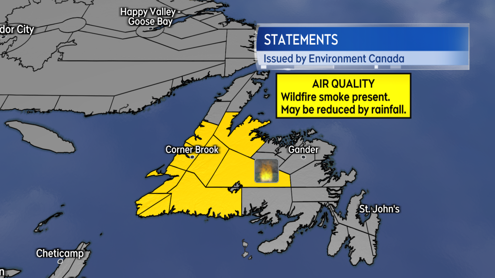
An easterly wind becoming northeast Tuesday night will accompany the rain. While the precipitation is likely to clear some smoke from the air, air quality statements are in effect for much of western Newfoundland as remaining wildfire smoke would be blown in that direction.

Air Quality Statements are in effect for western areas of Newfoundland as a prevailing easterly wind may blow smoke in that direction.
The weather for Wednesday and Thursday is expected to be mainly dry with a chance of showers returning on Friday. Wind on Thursday is expected to become southerly, which may once again start to blow wildfire smoke towards the north coast of Newfoundland.
CTVNews.ca Top Stories

Joly, Blair condemn anti-NATO protest in Montreal that saw fires, smashed windows
Federal cabinet ministers condemned an anti-NATO protest in Montreal that turned violent on Friday, saying 'hatred and antisemitism' were on display.
Canada Post down eight million parcels amid strike as talk carry on over weekend
Canada Post says it has seen a shortage of more than eight million parcels amid the ongoing strike that has effectively shut down the postal system for nine days compared with the same period of 2023.
NEW Thinking about taking an 'adult gap year'? Here's what experts say you should know
Canadian employees are developing an appetite for an 'adult gap year': a meaningful break later in life to refocus, refresh and indulge in something outside their daily routine, according to experts.
'Her shoe got sucked into the escalator': Toronto family warns of potential risk of wearing Crocs
A Toronto family is speaking out after their 10-year-old daughter's Crocs got stuck in an escalator, ripping the entire toe area of the clog off.
Walking pneumonia is surging in Canada. Is it peaking now?
CTVNews.ca spoke with various medical experts to find out the latest situation with the typically mild walking pneumonia in their area and whether parents should be worried.
Prime Minister Trudeau attends Taylor Swift's Eras Tour in Toronto with family
Prime Minister Justin Trudeau is a Swiftie. His office confirmed to CTV News Toronto that he and members of his family are attending the penultimate show of Taylor Swift's 'The Eras Tour' in Toronto on Friday evening.
Minister calls GST holiday, $250 cheques for 18 million Canadians 'a targeted approach'
Women and Gender Equality and Youth Minister Marci Ien is calling the federal government's proposed GST holiday and $250 rebate cheques a 'targeted approach' to address affordability concerns.
Afraid of losing the U.S.-Canada trade pact, Mexico alters its laws and removes Chinese parts
Mexico has been taking a bashing lately for allegedly serving as a conduit for Chinese parts and products into North America, and officials here are afraid a re-elected Donald Trump or politically struggling Prime Minister Justin Trudeau could try to leave their country out of the U.S.-Mexico-Canada free trade agreement.
Canada's tax relief plan: Who gets a cheque?
The Canadian government has unveiled its plans for a sweeping GST/HST pause on select items during the holiday period. The day after the announcement, questions remain on how the whole thing will work.


