Late week cold front expected to break Maritime heat wave
Summer heat wave
Although the definition can vary by region and country, it’s fairly safe to say the Maritimes is in the midst of a summer heat wave.
Heat warnings continue for all three provinces. For some areas, the warnings extend back into last week. You can look to a few coastal areas for more moderate temperatures thanks to a sea breeze, mainly the Bay of Fundy coastline of New Brunswick and parts of the southwestern Atlantic coastline of Nova Scotia.
Stay hydrated (water is best), take breaks to cool down, check on those who may be more vulnerable to the heat, and no person or pets should be left in a parked, closed vehicle for any period of time.
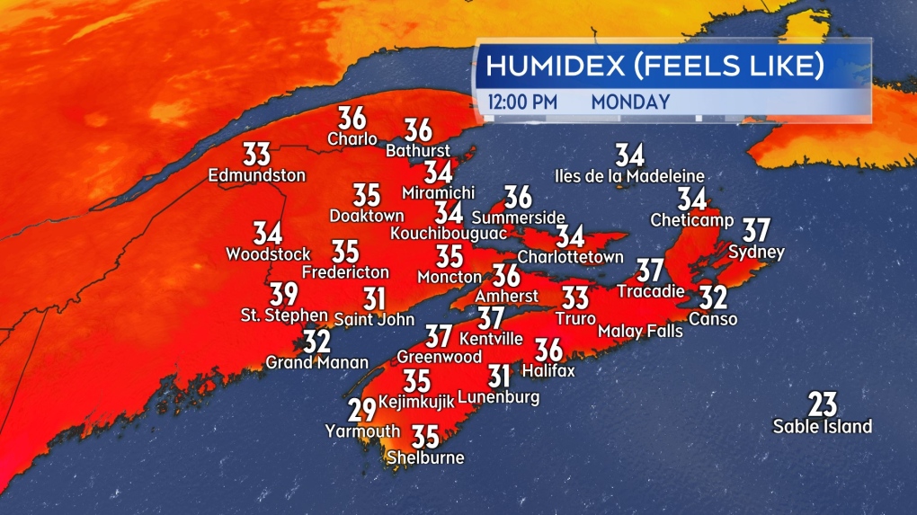 Just after noon on Monday and humidex values were already making it feel into the mid-to-high 30s for many communities in the Maritimes.
Thunderstorm risk
Hot and humid air can be fuel for thunderstorm development. While we have plenty of that, we are lacking a strong trigger to get thunderstorms to fire up. Examples of a trigger would include a trough of low pressure or a cold front, something to get the lift started in the atmosphere.
There is a chance of some pop-up thunderstorms Monday afternoon into early evening. They would be isolated in nature but could include downpours along with lightning. Areas with a higher chance of pop-up thunderstorms on Monday include northern and eastern New Brunswick, western Prince Edward Island, and interior areas of Nova Scotia.
The chance of thunderstorms will climb higher for both Tuesday and Wednesday as a trough of low pressure followed by a cold front approaches from the west.
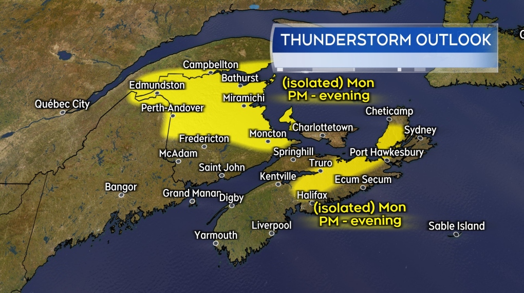 Some isolated, pop-up showers and thunderstorms created by the heat of the day possible on Monday.
Late-week relief
A cold front is expected to cross the Maritimes late Wednesday and Thursday. The passage of the front will bring scattered showers with a risk of thunderstorms in the Maritimes on both those days.
Wednesday will still be very hot and humid. Temperatures and humidity levels come down a bit for Thursday. Humidity will fall more for the Maritimes on Friday. It should be quite comfortable for most on Friday with high temperatures in the mid-to-high 20s and not much of a humidex to contend with.
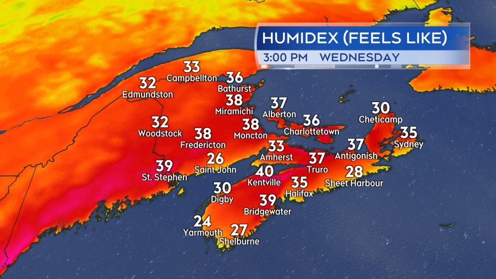 High humidex values expected on Wednesday. Humidity falls for the Maritimes Thursday into Friday.
Shopping Trends
The Shopping Trends team is independent of the journalists at CTV News. We may earn a commission when you use our links to shop. Read about us.


CTVNews.ca Top Stories

DEVELOPING
DEVELOPING Two-month GST holiday bill expected to pass the House tonight, Conservatives to vote against
The federal government's five-page piece of legislation to enact Prime Minister Justin Trudeau's promised two-month tax break on a range of consumer goods over the holidays, is expected to pass in the House of Commons by the end of the day.
Canada Post temporarily laying off striking workers, union says
The union representing Canada Post workers says the Crown corporation has been laying off striking employees as the labour action by more than 55,000 workers approaches the two-week mark.
Montreal shopping mall playing 'Baby Shark' song to prevent unhoused from loitering
A shopping mall and office complex in downtown Montreal is being criticized for using the popular children's song 'Baby Shark' to discourage unhoused people from loitering in its emergency exit stairwells.
B.C. man lied about cancer diagnosis while dodging $330K debt, court hears
A construction contractor from B.C.’s Lower Mainland has been ordered to repay a $330,000 loan from a friend who gave him leeway for years, despite her own financial suffering – all because she was under the false impression he had brain cancer.
Good Samaritan killed in tragic accident while helping stranded Calgary driver
Calgary police say a Good Samaritan who stopped to help another motorist was killed in an accident on Wednesday night.
Man jumps out of moving roller-coaster after safety belt fails
Terrifying video shows a man jumping out of a moving roller-coaster in Arizona after he says his safety belt failed.
The Vienna sausage stand is more than just a snack stall. Now it has a UNESCO heritage recognition
The Vienna sausage stand is a place where the street sweeper, the manager, the tourist and the celebrity converge for the same tasty snack. Now it also has the official stamp of approval as part of Austria’s heritage.
Competition Bureau suing Google, wants company to sell off two advertising services
The Competition Bureau is suing Google over alleged anticompetitive conduct in the tech giant's online advertising business and wants the company to sell off two of its services and pay a penalty.
Listeria contamination concerns prompt mushroom recall: Health Canada
Health Canada says customers across Ontario and Quebec should throw out or return any O’Ya hoho brand Enoki mushrooms due to listeria concerns.
Toronto
-

Video appears to show armed suspect attempting to carjack several drivers in Toronto's east end
Toronto police have released new details about a series of attempted carjackings and shootings that left one person seriously injured in Toronto’s east end on Wednesday night.
-
Another teenager charged with murder in fatal Scarborough shooting
A third teenager has been charged in connection with a shooting in Scarborough in July that left a 28-year-old man dead.
-
Toronto woman injured after falling out of wheelchair provided by Air Canada, husband says
What could have possibly been Sheila Rizzuto’s last vacation ever was ruined after she fell out of an Air Canada-provided wheelchair and badly injured herself, according to her husband.
Calgary
-

Carbon monoxide alarm forces evacuation of southeast Calgary building
Calgary fire crews responded to a carbon monoxide alarm Thursday morning in the city’s southeast.
-
Pedestrian killed after being hit by two vehicles while crossing Elbow Drive
Calgary police say a pedestrian was hit and killed while crossing Elbow Drive S.W. on Wednesday evening.
-
Good Samaritan killed in tragic accident while helping stranded Calgary driver
Calgary police say a Good Samaritan who stopped to help another motorist was killed in an accident on Wednesday night.
Edmonton
-

60-year-old woman accused of defrauding senior of at least $1.6M
Edmonton Police Service (EPS) has charged a 60-year-old woman for allegedly defrauding a local senior of at least $1.6 million.
-
Canada Post temporarily laying off striking workers, union says
The union representing Canada Post workers says the Crown corporation has been laying off striking employees as the labour action by more than 55,000 workers approaches the two-week mark.
-
'We want a negotiated contract': Local Canada Post workers remain steadfast as strike continues
Postal workers in Edmonton are holding their picket lines as the Canada Post strike nears its third week.
Montreal
-

Montreal shopping mall playing 'Baby Shark' song to prevent unhoused from loitering
A shopping mall and office complex in downtown Montreal is being criticized for using the popular children's song 'Baby Shark' to discourage unhoused people from loitering in its emergency exit stairwells.
-
'Clearly identifiable signs': Quebec report highlights domestic violence risk factors
A Quebec committee that examines domestic violence deaths has found that many victims aren't accessing the help they need even if the signs of violence are clear.
-
Montreal police say new patch for fallen officers will be available next week
Montreal police officers will soon have the option of wearing a new badge on their uniforms to commemorate their fallen members.
Ottawa
-

Striking Canada Post workers rally at head office in Ottawa
Over a hundred of Canada Post workers held a rally outside of the Crown corporation's head office in Ottawa on Thursday, as the strike job action by 55,000 postal workers nears the end of its second week.
-
Ottawa shoppers take advantage of Black Friday deals
In recent years, Black Friday and Cyber Monday have become less about the actual days, as deals are now spread out over weeks, or even a month-long period.
-
DEVELOPING
DEVELOPING Two-month GST holiday bill expected to pass the House tonight, Conservatives to vote against
The federal government's five-page piece of legislation to enact Prime Minister Justin Trudeau's promised two-month tax break on a range of consumer goods over the holidays, is expected to pass in the House of Commons by the end of the day.
London
-

'Shock, disappointment, and excitement': South Bruce not selected for nuclear waste project
Anja Vandervlies and Michelle Stein could hardly believe it when they heard South Bruce was not going to host Canada’s first permanent storage facility for nuclear waste.
-
Growing concerns at Fanshawe as Ontario colleges face financial uncertainty over international student caps
There are growing concerns about both staffing levels and programming at Fanshawe College as the federal government moves to cap international student visas.
-
Make-A-Wish holds annual Trees of Joy event in London, Ont.
Make-A-Wish Canada brought it’s annual Trees of Joy, presented by CN, to RBC Place in London, Ont. for the first time.
Barrie
-

Individuals living in encampment in Barrie's south end given notice to vacate
Several police officers and city staff attended a homeless encampment in Barrie’s south end on Thursday morning to inform the individuals living there they would have to vacate the area.
-
Man convicted of violent sexual assault of a senior could be deemed dangerous offender
The Crown wants a Wasaga Beach man to be deemed a dangerous or long-term offender following a violent sexual assault of a senior inside her Stayner home two years ago.
-
Kidnapping charge withdrawn against man accused in Elnaz Hajtamiri case
The charges against one of the men accused of kidnapping Ontario woman Elnaz Hajtamiri nearly three years ago were withdrawn and stayed by the Crown in a Collingwood courtroom this month.
Northern Ontario
-

Northern Ontario site selected for nuclear waste underground repository
A region in northern Ontario has been chosen as the site to hold Canada's nuclear waste in a deep geological repository.
-
Ongoing bed bug issue at a Timmins apartment building is 'like living in hell'
A battle with bed bugs continues at 217 Pine St. North in Timmins, according to a tenant who has lived there for a year and a half.
-
Sudbury family donates $1M to Health Sciences North Foundation
Di Brina Family Holdings announced Thursday it is donating $1 million to the Health Sciences North Foundation.
Kitchener
-

One dead, another hurt in Cambridge shooting
Waterloo Regional Police are investigating a fatal shooting in Cambridge.
-
Mother from Guelph, Ont. seeks answers following son's death in prison
Brody Robinson was found without vital signs in his cell at Millhaven Institution the evening of Oct. 29. He was 23-years-old.
-
Flurries, possibly even snow squalls, in southern Ontario’s forecast
Winter finally arrives this week in southern Ontario. Environment Canada is forecasting flurries and snow squalls almost every day.
Windsor
-

One man sought, one man arrested in kidnapping and extortion investigation
Windsor police officers have charged one man with 29 offences and they are seeking a second suspect in a kidnapping and extortion investigation.
-
Wrong-way driver arrested on E.C. Row Expressway
Windsor police say a 47-year-old man is facing impaired driving charges after going the wrong way on the E.C. Row Expressway.
-
13 vehicles stolen in Windsor this week: WPS
Windsor police are warning the public after a series of auto thefts this week.
Winnipeg
-

A tale of two downtowns: Restaurants opening and closing show complexity of downtown revival
Proposed developments and new businesses opening are fueling optimism for some on a revival of downtown Winnipeg, but some business owners say the present remains problematic.
-
Art auctioned from WAG-Qaumajuq to make way for new pieces representing Winnipeg
Visitors to the Winnipeg Art Gallery-Qaumajuq may soon see some brand new art hanging on its walls.
-
Supreme Court of Canada declines to hear appeal from former fashion mogul Nygard
The Supreme Court of Canada will not hear an appeal from former fashion mogul Peter Nygard.
Regina
-

Sask. forecasting $743.5M deficit in mid-year financial report, up $470.5M from budget
The provincial government says increases to crop insurance claims later in the growing season are a main reason for Thursday’s mid-year deficit forecast of $743.5 million, which is up more than $470 million from the budget.
-
Sentencing submissions presented in case of woman who defrauded Regina Mobile Crisis Services
The Crown and defence presented sentencing submissions at Saskatchewan Provincial Court on Thursday, in the case of a woman who pleaded guilty to defrauding Regina Mobile Crisis Services.
-
NDP asks province to cut PST on groceries, something Sask. premier says doesn't exist to begin with
The Saskatchewan NDP called on the province to cut the provincial sales tax (PST) on groceries Thursday as part of its plan to address ongoing cost of living concerns, but the premier says there is no such tax on groceries in the province.
Saskatoon
-

Extreme cold warning issued for Saskatoon
Environment Canada has issued an extreme cold warning for parts of central Saskatchewan, including Saskatoon, on Thursday.
-
Sask. forecasting $743.5M deficit in mid-year financial report, up $470.5M from budget
The provincial government says increases to crop insurance claims later in the growing season are a main reason for Thursday’s mid-year deficit forecast of $743.5 million, which is up more than $470 million from the budget.
-
'Got to deal with it': Saskatoon residents dealing with bumpy, snowy roads
Most of the main roads in Saskatoon are cleared, but feeder streets and residential roads are a different story.
Vancouver
-

B.C. man lied about cancer diagnosis while dodging $330K debt, court hears
A construction contractor from B.C.’s Lower Mainland has been ordered to repay a $330,000 loan from a friend who gave him leeway for years, despite her own financial suffering – all because she was under the false impression he had brain cancer.
-
'I was in shock': Vancouver Island couple win $500K lottery prize
A rural Vancouver Island couple are considering their retirement investment plans after winning $500,000 in a recent Lotto 6/49 draw, according to the B.C. Lottery Corporation.
-
Car 'stuck in a tree' after running red light, crashing: Richmond RCMP
A car crash in Richmond earlier this week sent two people to hospital and left a path of destruction in its wake.
Vancouver Island
-
B.C. man lied about cancer diagnosis while dodging $330K debt, court hears
A construction contractor from B.C.’s Lower Mainland has been ordered to repay a $330,000 loan from a friend who gave him leeway for years, despite her own financial suffering – all because she was under the false impression he had brain cancer.
-
'I was in shock': Vancouver Island couple win $500K lottery prize
A rural Vancouver Island couple are considering their retirement investment plans after winning $500,000 in a recent Lotto 6/49 draw, according to the B.C. Lottery Corporation.
-
New data sheds light on property flipping in B.C.
With B.C. poised to introduce a flipping tax, new data from Statistics Canada is shedding light on how many homes are bought and rapidly re-sold – and how profitable the venture has been.
Kelowna
-

Kelowna, B.C., to host the Memorial Cup in the spring of 2026
The Western Hockey League's Kelowna Rockets will host the Memorial Cup in the spring of 2026, the Canadian Hockey League said Wednesday.
-
545 vehicles impounded in 332 days: BC Highway Patrol pleads for drivers to slow down
Mounties with the BC Highway Patrol in Kelowna say they've impounded more than 545 vehicles for excessive speed and aggressive driving so far this year. That works out to more than 1.6 per day.
-
Man in hospital following targeted shooting in Kamloops
Police are appealing for information on a targeted shooting that resulted in the hospitalization of a man in Kamloops.


