Maritimes set for warmest days of 2023 so far
It’s the warmest stretch of the year so far to get this week started in the Maritimes. Aside from the coastlines, most high temperatures reached the low-to-mid teens on Monday. Temperatures are forecast even a few degrees higher for Tuesday. The warm-up is a result of the combination of sunshine and a southwest wind bringing in milder air out of southern Ontario and the northeastern U.S. Those areas are generally enjoying some high temperatures in the high teens and low twenties to start this week.
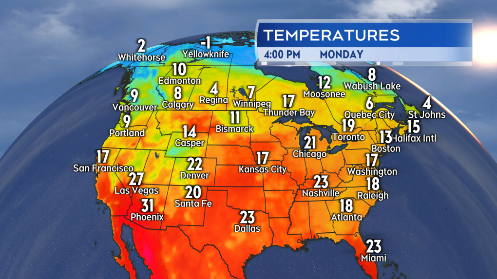 Warm air has built into Ontario and the northeastern U.S. We are catching a bit of that here in the Maritimes to start this week.
Looking at the provincial capitals for Tuesday, I have highs forecast near 16 for Fredericton and Halifax, and 14 for Charlottetown. That should be enough to get those cities their warmest day of the year so far. It will also likely be the warmest day since Nov. 12, 2022, when high temperature reached into the high-teens. For reference, the 30-year average high temperatures for this part of April are in the mid-to-high single digits in the Maritimes.
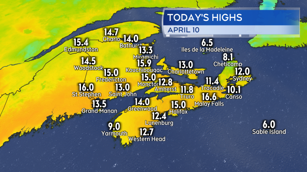 We started off this week with some of the warmest temperatures we’ve had to date this year.
While quite a few communities should get into the mid-teens Tuesday, there will still be some temperature variation in the region. The coastlines will probably top out between 9 and 12, likewise for the Cape Breton Highlands. Additionally, I’m not expecting to set new record high temperature records. A quick look at the standing records for an April 11 has most of them in the high teens and twenties. The UV index is starting to come up a bit. Rated as moderate for the Maritimes on Tuesday, some skin protection should be considered if out in the sun for 30 minutes or longer.
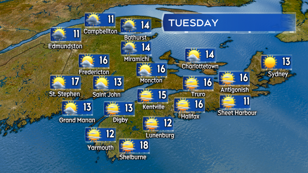 Temperatures forecast to be even a touch warmer on Tuesday. A chance of showers in northern New Brunswick beginning in the afternoon.
A low-pressure system moving out of Quebec will return showers to northern New Brunswick by late afternoon Tuesday. Showery weather will cross the Maritimes Tuesday night into Wednesday, with snow in the Cape Breton Highlands. The showers are followed by a northwest wind that will bring high temperatures back down into the mid-to-high single digits Wednesday. High temperatures should then start to climb back into the low teens Thursday and mid-teens Friday. It’s expected to be cooler again on parts of the coast, mainly due to the surrounding ocean water temperatures currently running between 1 and 6 degrees.
Barring a major change in the extended forecast, the upcoming weekend looks like it will feature some fairly sunny and warm April weather as well.
I’ll have updates and regional weather conditions on CTV News Atlantic programming at 5, 6, and 11:30 p.m.
Shopping Trends
The Shopping Trends team is independent of the journalists at CTV News. We may earn a commission when you use our links to shop. Read about us.


CTVNews.ca Top Stories

Downtown Vancouver stabbing suspect dead after being shot by police
A suspect is dead after being shot by police in a Vancouver convenience store after two people were injured in a stabbing Wednesday morning, according to authorities.
DEVELOPING
DEVELOPING As police search for suspect, disturbing video surfaces after U.S. health-care CEO gunned down in New York
UnitedHealthcare CEO Brian Thompson was killed Wednesday morning in what investigators suspect was a targeted shooting outside a Manhattan hotel where the health insurer was holding an investor conference.
'Utterly absurd': Freeland rebuffs Poilievre's offer of two hours to present fall economic statement
Deputy Prime Minister and Finance Minister Chrystia Freeland has rebuffed Conservative Leader Pierre Poilievre's offer to give up two hours of scheduled opposition time next Monday to present the awaited fall economic statement as 'utterly absurd.'
Transport Minister to summon airline CEOs as Air Canada set to charge carry-on fees for some passengers
Transport Minister Anita Anand says she will be calling Canadian airline CEOs to a meeting in mid-December after Air Canada says it will charge some passengers for carry-on bags in the new year.
Millions in Cuba remain in dark after nationwide blackout
Cuba said it was generating only enough electricity to cover about 1/6th of peak demand late on Wednesday, hours after its national grid collapsed leaving millions without power.
Canada Post stores continue to operate during strike — but why?
As many postal workers continue to strike across the country, some Canadians have been puzzled by the fact some Canada Post offices and retail outlets remain open.
Mattel sued over 'Wicked' dolls with porn website link
Mattel was sued this week by a South Carolina mother for mistakenly putting a link to an adult film site on the packaging for its dolls tied to the movie 'Wicked.'
Mitch Marner to wear red and white Maple Leaf as Canada rounds out 4 Nations roster
Mitch Marner was among the 15 players added to Canada's roster for the NHL 4 Nations Face-Off tournament Wednesday.
Two children wounded and gunman dead after shooting at Northern California school
Two students were wounded in a shooting Wednesday at a small religious school in Northern California and the shooter died from a suspected self-inflicted gunshot, sheriff's officials said.
Toronto
-

WATCH: Suspects armed with hammers hit Markham jewelry store
Six suspects are in custody in connection with a smash-and-grab robbery at a jewelry store in a Markham mall that was captured on video.
-
5 individuals wanted for GTA murders added to Canada’s most-wanted fugitives list
Five individuals being sought by police in the GTA have been added to a list of Canada’s most wanted fugitives.
-
Toronto remain under winter weather travel advisory
Toronto got its first taste of winter weather Wednesday as a low-pressure system brought snow to the city.
Calgary
-

Former Calgary police officer wanted on Canada-wide warrant
Calgary police have issued a Canada-wide warrant for a former officer they say used police resources to contact women he met while on duty.
-
Alberta cattle producers express optimism in wake of Trump's tariff threat
Cattle producers in Alberta don't appear to be overly concerned by the threat of tariffs by United States president-elect Donald Trump.
-
Calgary could consider banning retail sale of dogs, cats and rabbits
A Calgary committee will consider asking city officials to ban all sales of dogs, cats and rabbits in retail stores.
Edmonton
-

Lucy the elephant in good health, but should remain in Edmonton: experts
Lucy the elephant is in good health and able to travel – though experts recommend she stays put.
-
Removal of Treaty 6 flag in Barrhead a 'step backwards' for reconciliation: Grand Chief
Treaty No. 6 First Nations Grand Chief Cody Thomas says the removal of the Treaty 6 flag in municipalities is a “mistake” and a “step backwards” for reconciliation.
-
Collectors believe stamp hobby will endure despite unclear future of strike-embroiled Canada Post
Even with the future of Canada Post in question, given the Crown corporation's mounting financial losses and loss of business due to a strike by postal workers, stamp collectors say they feel their hobby will ride out the uncertainty.
Montreal
-

Former Montreal mayor Denis Coderre owes nearly $400K to tax agencies
The Canada Revenue Agency is seeking more than $260,000 from former Montreal mayor Denis Coderre in a mortgage recovery filing.
-
Drivers zig-zagging and posting videos in white-lining trend: Quebec prosecutors
A Montreal man is facing a criminal charge of dangerous driving after he allegedly posted a video of himself zig-zagging through cars. It's a trend called 'white lining.'
-
Quebec adopts motion on sexual exploitation of minors
The Quebec legislature has adopted a motion to denounce a publicly funded organization that promotes 'forms of sexual exploitation of minors,' according to the Parti Québécois (PQ).
Ottawa
-

Protester disrupts City of Ottawa information session about Sprung structure
A man wearing a t-shirt that said "No tent in Ottawa" disrupted a City of Ottawa info session about the proposed Sprung structure that is set to be built along Woodroffe Avenue near the Nepean Sportsplex.
-
WINTER WEATHER TRAVEL ADVISORY
WINTER WEATHER TRAVEL ADVISORY 10 cm of snow in the forecast, OPP urging drivers to drive safely in Ottawa and eastern Ontario
Cold temperatures and snow amounting to 10 centimetres are in the forecast for Ottawa this Wednesday. A winter weather travel advisory is in effect and police are asking people to drive safely.
-
Ottawa's chief medical officer Dr. Vera Etches to become head of CHEO
Ottawa’s medical officer of health Dr. Vera Etches has been appointed as the president and CEO of the Children's Hospital of Eastern Ontario (CHEO).
London
-

Another blast of snow is expected to roll through on Thursday
Environment Canada has issued a blowing snow advisory for the London region Wednesday, which is expected to be followed with more snow in the forecast on Thursday.
-
Pedestrian struck in northeast London
London police say that one person has been transported to hospital with serious injuries as the result of a collision this afternoon.
-
Interest rate cut fuels increase in home sales: London-St. Thomas Association of Realtors
“Little bit of pent-up demand. People were waiting to see the sign that the rates were going to stay stable and probably continue to go down a little bit,” said association CEO Bill Madder.
Barrie
-

Snow squall warning issued for Simcoe County, with up to 30 cm of snow accumulation likely
Snow squall warnings were issued Wednesday for Barrie and surrounding areas, with snow accumulations up to 30 centimetres likely.
-
17-year-olds arrested with loaded gun, drugs in Barrie, police say
Police in Barrie say two teens were arrested for having a loaded gun and drugs in their possession.
-
Winter travel advisory issued as Muskoka braces for more snow
Muskoka is in for more snow after a major dumping over the weekend that caused power outages, downed trees and road closures.
Northern Ontario
-

Family reeling as victim of Sudbury stabbing left paralyzed
A GoFundMe has been set up to help support Josee Rouleau, the victim of a stabbing that happened in Chelmsford in Greater Sudbury on Nov. 22.
-
Warm, wet winter expected in much of Canada, say forecasters
Federal forecasters expect a warmer-than-normal start to winter in most of Canada, with more precipitation than usual in parts of the country.
-
Transport Minister to summon airline CEOs as Air Canada set to charge carry-on fees for some passengers
Transport Minister Anita Anand says she will be calling Canadian airline CEOs to a meeting in mid-December after Air Canada says it will charge some passengers for carry-on bags in the new year.
Kitchener
-

Waterloo Regional Police recover 52 vehicles from chop shop in North Dumfries, Ont.
A chop shop in North Dumfries, Ont. has been dismantled after police found 52 stolen vehicles.
-
Rescue of three boys from Cambridge pond prompts safety plea from officials
Three 13-year-old boys fell through the ice at a Cambridge pond on Tuesday. We spoke to the Lifesaving Society of Ontario about how to stay safe on and in the water this winter.
-
Transport Minister to summon airline CEOs as Air Canada set to charge carry-on fees for some passengers
Transport Minister Anita Anand says she will be calling Canadian airline CEOs to a meeting in mid-December after Air Canada says it will charge some passengers for carry-on bags in the new year.
Windsor
-

Rising profits or closing brick and mortar stores: the impact of the ongoing Canada Post strike
Most local businesses have found alternative ways to ship their products to customers during the Canada Post Strike.
-
Mourning the loss of dramatic arts program, UWindsor students turn grief into performing arts piece
Following budget cuts resulting in no theatre company like the University Players to rely on anymore, dramatic arts students were devastated.
-
'Hollywood Holidays' celebrates Christmas flicks at the Chrysler Theatre
St. Clair College student-performers are spreading Christmas cheer as they prep for opening night of their upcoming Hollywood Holidays production.
Winnipeg
-

Proposed site for Winnipeg supervised consumption site in the city's core
The province’s first supervised consumption site could soon be located along the Disraeli Freeway in Winnipeg.
-
Province wants to discharge private nursing numbers
The Manitoba government wants to reduce the reliance on private nurses in the public health care system.
-
Canadian appears in U.S. court in decades-old cold case
Robert Creter made his first court appearance since his extradition to the United States from Winnipeg. He's the prime suspect in the murder of 23-year-old Tami Tignor – a cold case dating back to 1997.
Regina
-

'It's all about tradition': Bushwakker marking 30 years of blackberry mead
The ancient art of meadmaking has become a holiday tradition for Regina's Bushwakker Brewpub, marking 30 years of its signature blackberry mead on Saturday.
-
Newly elected Regina city council meets for first executive committee meeting
On Wednesday, council held their first executive committee meeting, which included a first look at the 2025 city budget.
-
Sask. auditor releases findings on social services’ hotel spending
An audit stemming from concerns over government practices of securing hotel rooms for those on social assistance has been released.
Saskatoon
-

Saskatoon boy, 16, faces first-degree murder charge in death of woman found outside the Copper Mug
A 16-year-old boy faces a first-degree murder charge in the case of a woman found dead in an 8th Street parking lot last month.
-
Saskatchewan maintains dismal status as leader in spread of HIV, with no provincial strategy in place
Advocates for Saskatchewan’s HIV-positive residents are calling for a provincial strategy to support those living with the virus, and to help stop its spread.
-
Saskatoon Food Bank demand up 25 per cent in 2024
The Christmas season is one of the busiest times of the year for the Saskatoon Food Bank, as donations pour in from the community. However, this year’s demand underscores a growing crisis.
Vancouver
-
Downtown Vancouver stabbing suspect dead after being shot by police
A suspect is dead after being shot by police in a Vancouver convenience store after two people were injured in a stabbing Wednesday morning, according to authorities.
-
Suspect arrested after stabbing sends man to hospital in Surrey, B.C.
Police say one man is in custody and another is in hospital after a stabbing Wednesday morning in Surrey, B.C.
-
Early-rising Taylor Swift fans wait for hours in Vancouver for concert gear
Taylor Swift fans were up before the sun in Vancouver to snag some coveted shirts, bags and sweaters to mark her record-breaking Eras Tour.
Vancouver Island
-
Downtown Vancouver stabbing suspect dead after being shot by police
A suspect is dead after being shot by police in a Vancouver convenience store after two people were injured in a stabbing Wednesday morning, according to authorities.
-
Federal minister Harjit Sajjan to attend Taylor Swift concert with taxpayer-funded ticket
Harjit Sajjan, the federal minister responsible for the Pacific Economic Development Agency of Canada, will be going to the Eras Tour on taxpayer dollars.
-
Environment Canada warns fog causing near-zero visibility in southwest B.C.
Environment Canada is warning travellers that dense fog is creating near-zero visibility in parts of southwestern British Columbia on Wednesday.
Kelowna
-

Study of 2023 Okanagan wildfires recommends limiting development in high-risk areas
A study into the devastating wildfires that struck British Columbia's Okanagan region in 2023 has recommended that government and industry limit development in high-fire-risk areas.
-
Kelowna, B.C., to host the Memorial Cup in the spring of 2026
The Western Hockey League's Kelowna Rockets will host the Memorial Cup in the spring of 2026, the Canadian Hockey League said Wednesday.
-
545 vehicles impounded in 332 days: BC Highway Patrol pleads for drivers to slow down
Mounties with the BC Highway Patrol in Kelowna say they've impounded more than 545 vehicles for excessive speed and aggressive driving so far this year. That works out to more than 1.6 per day.


