More spring snow to hit the Maritimes Sunday
While one round of snow and rain has passed, another is lined up for the end of the weekend.
The system that rolled through Thursday night into Friday brought the most snow to parts of northern and eastern New Brunswick, Prince Edward Island, and Cape Breton.
Those areas of New Brunswick and Prince Edward Island saw a widespread 10 to 20 cm. Meanwhile, Victoria County and the Sydney Metro-Cape Breton County areas saw snow totals in the 20 to 35 cm range.
More snow is possible for Cape Breton Friday night into early Saturday morning as a northwesterly wind brings in flurries off the Gulf of St. Lawrence.
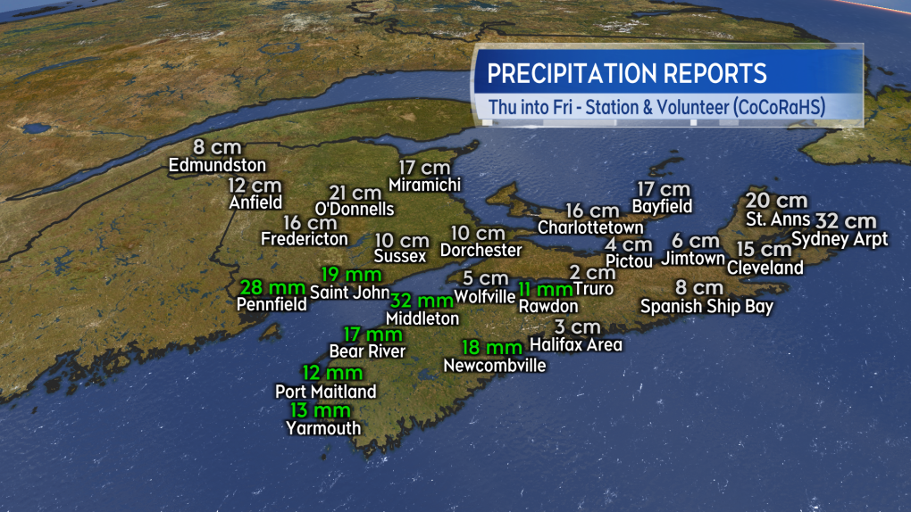 Preliminary and unofficial snow and rain reports for the Thursday/Friday system.
With a ridge of high-pressure building in from the west, Saturday will see the fairest weather of the weekend. There will be a general mix of sun and cloud and a low chance of flurries in Nova Scotia around the North Shore and Cape Breton.
High temperatures will generally be in the low-to-mid single digits for the Maritimes with communities on the South Shore of Nova Scotia possibly reaching 7 C to 10 C. Wind will be breezy and variable in direction for New Brunswick.
Wind will be blustery and from the north for both Nova Scotia and Prince Edward Island. That brings us to Sunday and our next round of active weather.
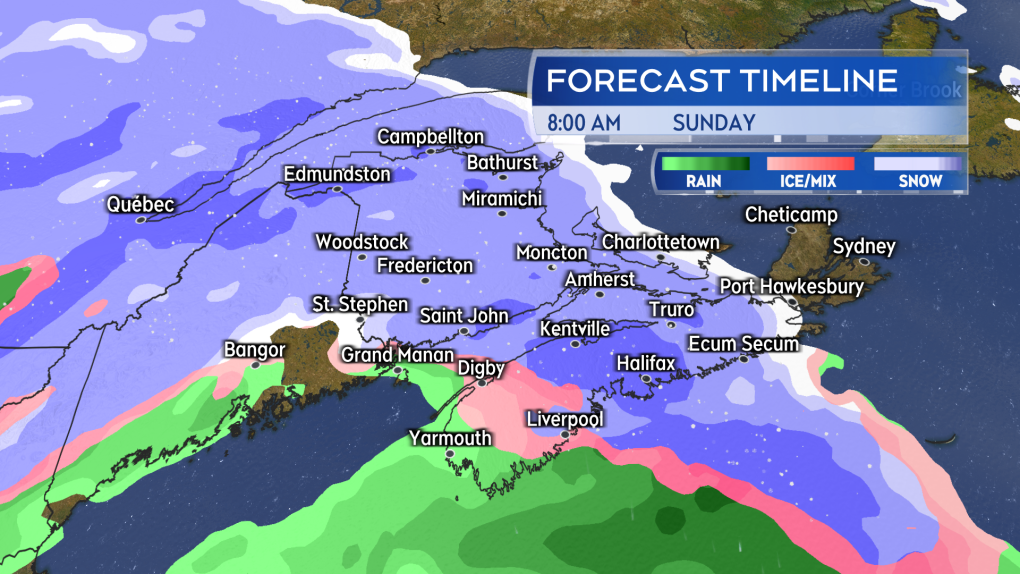 Snow returns Sunday morning to the Maritimes. The snow mixing over to ice pellets and rain in southwestern New Brunswick and western Nova Scotia.
As Saturday’s high-pressure shifts to the east, space will open for a low-pressure system to move in from the northeastern United States on Sunday.
Snow will likely start in western New Brunswick and western Nova Scotia before sunrise Sunday. The snow will reach eastern New Brunswick, Prince Edward Island, and eastern Nova Scotia before noon.
A turn from snow to a mix of ice pellets and rain is expected around coastal southwestern New Brunswick and western Nova Scotia. Snow, ice pellets and rain will become lighter Sunday evening. Lighter snow and flurries are likely to linger in some areas into Monday morning.
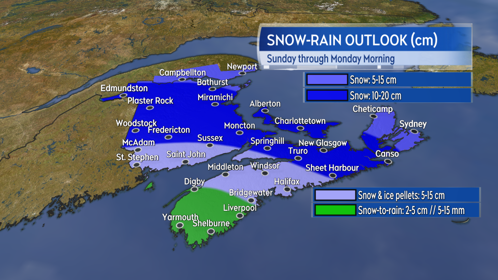 A large area of the Maritimes could pick up another 10 to 20 cm of snow. Snow amounts lower where more ice pellets and rain are present.
Given the mix of precipitation, it's hard to tell what amounts will look like – particularly at a time of year when the sun is getting stronger.
Once again, it looks like northern and eastern areas of the Maritimes will have the highest chance of picking up 10 to 20 cm of snow. Snow may taper lower in Cape Breton if the island ends up on the northern part of the storm.
Southwestern New Brunswick and central Nova Scotia will see varied amounts of five to 15 cm in a mix of snow, ice pellets, and rain. Accumulation there will be heavily dependent on the nature of that mix. A turn to rain does look likely in southwestern Nova Scotia, which may limit snow amounts there to five cm or less.
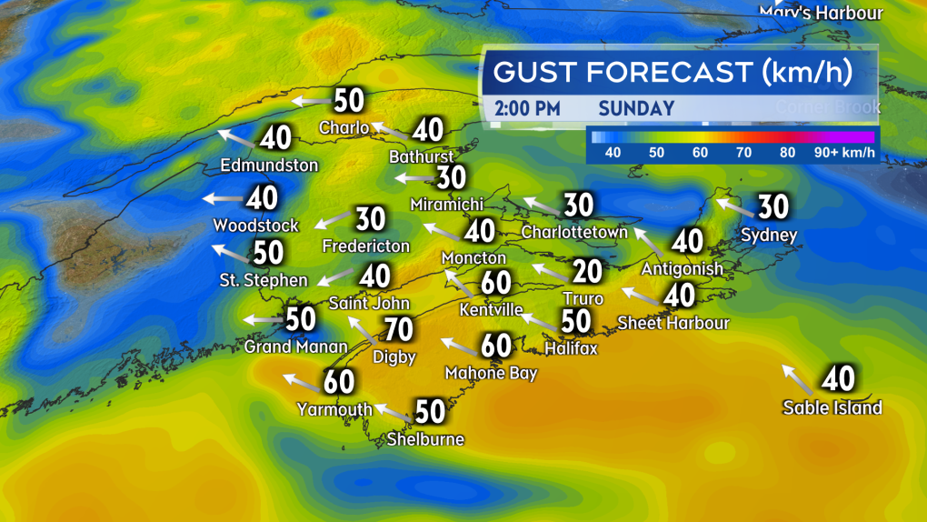 Gusty easterly winds will accompany the mix of snow, ice pellets, and rain Sunday.
A gusty, easterly wind will accompany the mix of precipitation. That wind will pick up Sunday morning into the afternoon. Gusts look to peak in the range of 40 to 70 km/h with the strongest on exposed areas of the coast and at higher terrain. The wind turns northerly and diminishes Sunday night into Monday morning.
CTVNews.ca Top Stories

'Too young to have breast cancer': Rates among young Canadian women rising
Breast cancer rates are rising in Canada among women in their 20s, 30s and 40s, according to research by the University of Ottawa (uOttawa).
Sophie Gregoire Trudeau on navigating post-political life, co-parenting and freedom
Sophie Gregoire Trudeau says there is 'still so much love' between her and Prime Minister Justin Trudeau, as they navigate their post-separation relationship co-parenting their three children.
'I was scared': Ontario man's car repossessed after missing two repair loan payments
An Ontario man who took out a loan to pay for auto repairs said his car was repossessed after he missed two payments.
Charlie Woods, son of Tiger, shoots 81 in U.S. Open qualifier
Charlie Woods failed to advance in a U.S. Open local qualifying event Thursday, shooting a 9-over 81 at Legacy Golf & Tennis Club.
Canada recognizes housing as a human right. Few provinces have followed suit
As more Canadians find themselves struggling to afford or find housing, the country's smallest province is the only one that can point to legislation recognizing housing as a human right.
'Violation': CSIS had officer investigated after she reported a superior raped her
A CSIS officer's allegations that she was raped repeatedly by a superior in agency vehicles set off a harassment inquiry, but also triggered an investigation into her that concluded the alleged attacks were a “misuse” of agency vehicles by the woman.
What to know about avian influenza in dairy cows and the risk to humans
Why is H5N1, or bird flu, a concern, how does it spread, and is there a vaccine? Here are the answers to some frequently asked questions about avian influenza.
Pro-plastic lobbyist presence at UN talks is 'troubling,' say advocates
Environmentalist groups are sounding the alarm about a steep increase in the number of pro-plastic lobbyists at the UN pollution talks taking place this week.
opinion The special relationship between King Charles and the Princess of Wales
Royal commentator Afua Hagan writes that when King Charles recently admitted Catherine to the Order of the Companions of Honour, it not only made history, but it reinforced the strong bond between the King and his beloved daughter-in-law.


