First significant snow of the season for parts of the Maritimes Thursday, Friday
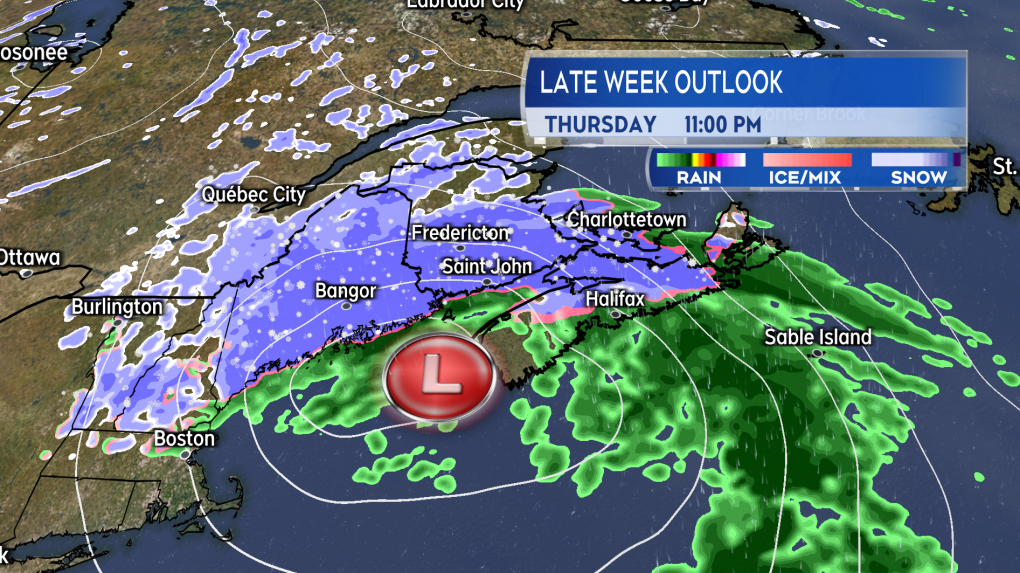
A low-pressure system moving up the eastern seaboard of the United States is forecasted to bring a mixture of snow and rain into the Maritimes Thursday night into Friday.
 A low-pressure system moving up the eastern seaboard brings a mix of snow and rain to the Maritimes Thursday night into Friday. (Source: CTV News Atlantic)
Snowfall outlook
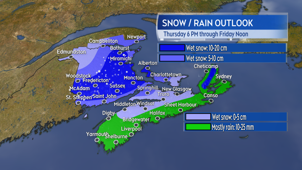
Cutting straight to the chase, here is my current outlook for potential snowfall.
 Accumulations in a wet and slush snow are possible for a number of areas in the region Thursday night into Friday morning. (Source: CTV News Atlantic)
Given the track of the system is expected to come in either across Nova Scotia or up the Bay of Fundy, the most primed area for snowfall will be New Brunswick. Much of the southern and central part of the province should anticipate five-to-15 cm of heavy, wet snow.
Western areas of Prince Edward Island could also pick up totals exceeding 10 cm with lower amounts further east in the province where more rain is expected.
There will be some tricky spots in Nova Scotia as well, mostly due to higher terrain. Watch the trouble spots of the Cobequid Pass and Mount Thom areas to pick up some slippery, slushy accumulation. The Cape Breton Highlands could also pick up 10-plus cm of wet snow. Much of the remainder of Nova Scotia may see some snow but also rain with general totals of 10-to-25 mm.
The timing of this system has the bulk of the snow falling Thursday night and early Friday morning. Best to plan for slippery and disrupted commutes Friday morning for areas that pick up higher snow amounts. Give yourself time and space on the roads.
As of noon Wednesday, Environment Canada has some areas under a Special Weather Statement, cautioning that snow totals could reach 15 cm. Continue to monitor that weather agency for updates to those statement and any further alerts issued.
Gusty wind
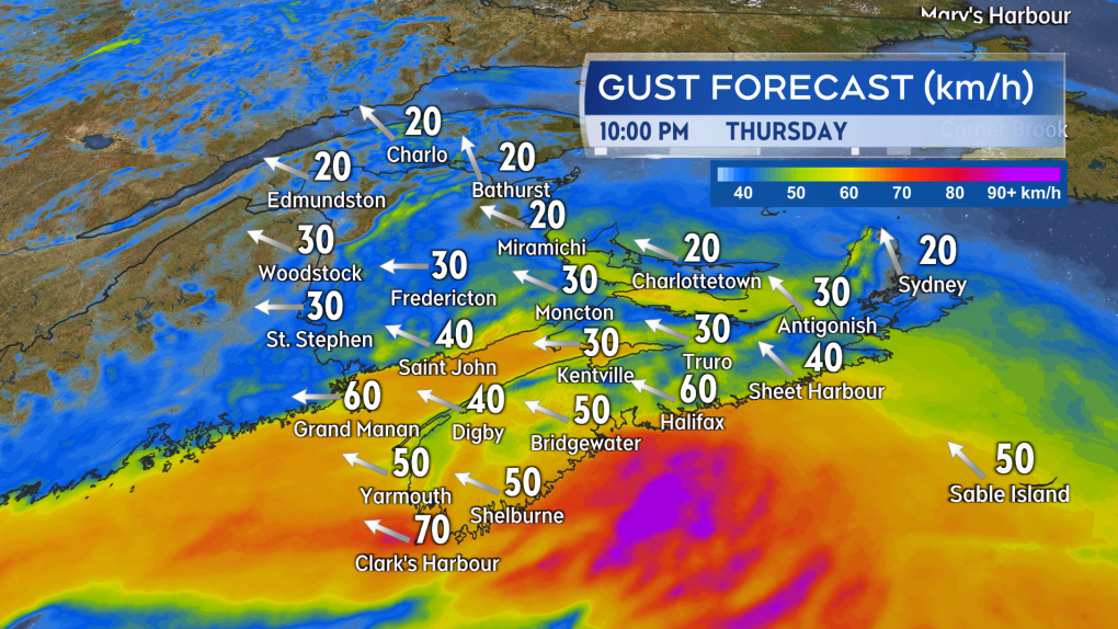
A gusty easterly wind will develop as the mix of snow and rain moves in.
Peak gusts of 30-to-50 km/h can be expected for most of the Maritimes. Gusts on exposed areas of the Atlantic coastline could peak at 50-to-70 km/h. Due to the topography of the Cape Breton Highlands, northern Inverness County could hit some gusts as high as 90-to-120 km/h early Friday morning.
By Friday afternoon the wind will become northwest with gusts of 30-to-60 km/h.
 A gusty easterly wind will accompany the mix of precipitation on Thursday night. (Source: CTV News Atlantic)
Chilly temperatures follow
There is a round of colder Arctic air slowly working west-to-east across the continent.
A westerly wind Friday through the weekend will allow for some of that to filter into the Maritimes.
Expect daytime high temperatures near to just above freezing for much of the Maritimes starting Saturday and continuing next week. Overnight low temperatures will fall a few to several degrees below zero.
CTVNews.ca Top Stories

Missing hiker found alive after 50 days in northern B.C. wilderness
A missing hiker who spent 50 days alone in the frozen wilderness of northern British Columbia has been found alive.
'They alone are responsible': No deal yet in Canada Post strike
The Canada Post strike is expected to continue as parties remain 'too far apart on critical issues' to reach a deal, according to Labour Minister Steven MacKinnon.
Hyundai recalling hundreds of thousands of cars and SUVs in Canada, U.S.
Hyundai is recalling hundreds of thousands of SUVs and small cars in the U.S. and Canada because the rearview camera image may not show up on the screens.
Ontario to match GST holiday by removing provincial sales tax on some items
The Ontario government says it will match the federal government’s GST holiday by removing provincial sales tax (PST) from items that are not currently covered by existing provincial rebates.
Man arrested at LAX after allegedly checking suitcases filled with over 70 pounds of meth-caked clothing
A California man was arrested at Los Angeles International Airport after he allegedly tried to check two suitcases containing more than 70 pounds of clothing caked in methamphetamine – including a cow pajama onesie – on a flight to Australia, federal prosecutors said Tuesday.
Some Liberal MPs echo NDP call to expand $250 rebate, minister touts seniors benefits
Some Liberal MPs say they think their government should consider expanding the eligibility for an upcoming government rebate to include seniors who are no longer working.
Cynthia Erivo and Ariana Grande 'Wicked' pay disparity rumour debunked
Some have been saying Ariana Grande got paid more for 'Wicked' than her costar Cynthia Erivo, but the movie's studio is setting the record straight.
W5 Investigates Canada's least wanted man: A family's long and lonely fight to bring their son home from Syria
Counterterrorism experts and humanitarian groups are urging countries to repatriate suspected ISIS members, as one family tells CTV W5 about their long and lonely fight to bring their son home from Syria.
Montreal billionaire Robert Miller could have as many as 100 victims, lawyer says
A Quebec judge is hearing arguments this week in a class-action lawsuit application against Montreal billionaire Robert Miller over allegations he paid minors for sex.


