Northeast New Brunswick, Cape Breton Highlands among areas to receive most snow through Friday
 Pedestrians make their way down Bell Road as heavy snow and gusting winds continue to hit Halifax on Sunday, Feb. 4, 2024. (Source: THE CANADIAN PRESS/Darren Calabrese)
A large and slow-moving area of low pressure brings periods of a snow, rain mix across the Maritimes Thursday into the start of the weekend.
Slick roads develop Thursday
The first of the snow arrives in southwest New Brunswick and southwest Nova Scotia before sunrise on Thursday. Wet snow will then spread across New Brunswick and mainland Nova Scotia during the day. There will be a chance of flurries or showers for both Prince Edward Island and Cape Breton. The snow may mix with rain for Nova Scotia and parts of southern New Brunswick.
Snow amounts of five-to-15 cm are expected in southwestern New Brunswick and western Nova Scotia Thursday afternoon into the evening. Accumulation may be varied due to some of the snow melting as it reaches the ground and if any rain mixes in. Drivers should be cautious of possible snowy, slushy accumulations that could make roads slick. Visibility may also be reduced in falling snow for periods of time.
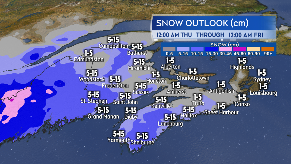 Watch for snowy or slushy accumulations on roads during the day, especially in southwestern New Brunswick an western Nova Scotia. (Source: CTV News Atlantic)
A high and gusty easterly wind is expected to develop for parts of the Maritimes on Thursday. Gusts could reach 50-to-70 km/h for southern New Brunswick, Nova Scotia, and Prince Edward Island Thursday afternoon and night. Exposed coastal areas of the southwestern coastlines of New Brunswick and Nova Scotia could have maximum wind gusts of 70-to-100 km/h.
More snow adds up Friday
Thursday night and Friday morning will see the heavier snow shift into eastern New Brunswick, eastern Nova Scotia, and western Prince Edward Island. That could make for a snowy, slippery Friday in communities such as Bathurst, Moncton, and Sydney, among others. A general five-to-15 cm of wet snow, but more for a few areas.
Northeast New Brunswick could see snow totals of 15-to-30 cm for the area from Miramichi north to Campbellton and east across the Acadian Peninsula. Thirty-to-45 cm are possible in the highest elevations of Northumberland, Gloucester, and eastern Restigouche counties. The highest elevations of the Cape Breton Highlands could also possibly pick up snow approaching 30 cm.
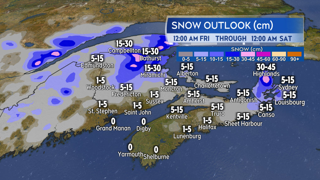 Heavier snow accumulation possible in northeastern New Brunswick and the Cape Breton Highlands on Friday. (Source: CTV News Atlantic)
Other areas of the Maritimes can expect a lighter mix of flurries and showers through the day. Wind will be out of the east and southeast on Friday with gusts of 30-to-60 km/h.
Lingers into Saturday
As the centre of the low stalls to the east of the Maritimes, further periods of a snow-rain mix are possible Friday night and Saturday. Given the multi-day duration of the weather event, it is early to assess how much additional snow could fall on Saturday. In most cases it looks like it will be lighter compared to the areas of steadier snow expected Thursday and Friday. There will be a northeast wind on Saturday with gusts of 20-to-50 km/h.
Forward to Monday and the eclipse
If we are looking for a silver lining in the forecast, it is the outlook for eclipse viewing on Monday. A weak ridge of high pressure is expected to be building from the west. That should keep clouds in the Maritimes patchy in coverage for Monday afternoon.
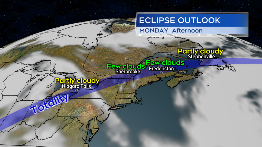 Fingers crossed, but the overall weather pattern looks favourable for solar eclipse viewing on Monday in the Maritimes. (Source: CTV News Atlantic)


CTVNews.ca Top Stories

Celine Dion delivers stirring comeback performance at Paris Olympics opening ceremony
Against the rainy Paris night sky, Celine Dion staged the comeback of her career with a powerful performance from the Eiffel Tower to open the Olympic Games.
Jasper wildfire: 'Several weeks' before residents can return, premier says
Premier Danielle Smith said Friday afternoon in Hinton while weather conditions are cooler, the Jasper fire is still considered out of control and that Jasper residents can expect to be away from their homes 'for several weeks.'
Missing 3-year-old boy found dead in creek in Mississauga: police
A three-year-old boy has been found dead a day after he went missing in a park in Mississauga, Peel police say.
Irish museum pulls Sinead O'Connor waxwork after just one day due to backlash
An Irish museum will withdraw a waxwork of singer-songwriter Sinéad O'Connor just one day after installing it, following a backlash from her family and the public, it told CNN in a statement on Friday.
Winnipeg senior's account overdrawn for $146,000 water bill
A Winnipeg senior is getting soaked with a six-figure water bill.
Turpel-Lafond won't sue CBC over Cree heritage report that took 'heavy toll': lawyer
The lawyer for a former judge whose claims to be Cree were questioned in a CBC investigation says his client is not considering legal action against the broadcaster after the Law Society of British Columbia this week backed her claims of Indigenous heritage.
Driver charged after flashing high beams at approaching police
Orillia OPP arrested and charged a driver with impaired driving after flashing their high beams.
Major Canadian bank experiences direct deposit outage on payday
Scotiabank says it has fixed a technical issue that impacted direct deposits on Friday morning.
Health Canada warns some naloxone kits contain false instructions
Health Canada is warning some take-home naloxone kits come with bad instructions that should be ignored in favour of the correct guidance.
Shopping Trends
The Shopping Trends team is independent of the journalists at CTV News. We may earn a commission when you use our links to shop. Read about us.


Toronto
-

Missing 3-year-old boy found dead in creek in Mississauga: police
A three-year-old boy has been found dead a day after he went missing in a park in Mississauga, Peel police say.
-
Man wanted after allegedly attempting to grab child in east Toronto
Police are searching for a man who allegedly attempted to grab a child in east Toronto earlier this month.
-
Toronto Zoo shares what led to 2-year-old giraffe’s death
The Toronto Zoo has shared the cause of death for a young giraffe that passed away on Thursday.
Calgary
-

Jasper wildfire: 'Several weeks' before residents can return, premier says
Premier Danielle Smith said Friday afternoon in Hinton while weather conditions are cooler, the Jasper fire is still considered out of control and that Jasper residents can expect to be away from their homes 'for several weeks.'
-
3 dead in Rocky View County crash
Three people are dead following a motor vehicle collision in Rocky View County on Friday morning.
-
Water restrictions remain as more wire snaps detected along feeder main
A city official says Calgary will remain under Stage 1 outdoor water restrictions while it investigates potential points of concern along its recently repaired feeder main.
Edmonton
-
Jasper wildfire: 'Several weeks' before residents can return, premier says
Premier Danielle Smith said Friday afternoon in Hinton while weather conditions are cooler, the Jasper fire is still considered out of control and that Jasper residents can expect to be away from their homes 'for several weeks.'
-
Connor McDavid getting married this weekend. Here's everything we know about the big day
McDavid and longtime girlfriend Lauren Kyle got engaged in Ontario last summer and are getting married there on Saturday.
-
New numbers confirm one-third of Jasper townsite destroyed in this week's wildfire
One-third of all structures in the townsite of Jasper are gone, burned to the ground in this week’s wildfire, officials confirmed Friday.
Montreal
-
Celine Dion delivers stirring comeback performance at Paris Olympics opening ceremony
Against the rainy Paris night sky, Celine Dion staged the comeback of her career with a powerful performance from the Eiffel Tower to open the Olympic Games.
-
Montrealer living in Jasper hopes home will be spared from fire
As the wildfires continue to rage in Alberta, a Montreal man who has lived in Jasper for over 20 years watches anxiously, hoping his home will be spared.
-
Environmental activists target Montreal airport for third consecutive day
Environmental activists have caused disruptions outside Montreal Trudeau International Airport for three consecutive days protesting Canadian fossil fuel policy.
Ottawa
-

Former Ottawa Senators assistant coach Bob Jones dies at 54 after battle with ALS
The Ottawa Senators have announced that former assistant coach Bob Jones has died after a battle with ALS. He was 54.
-
Family farm near Christie Lake destroyed by Perth, Ont. tornado
A family in the community of Tay Valley is picking up the pieces of their barn after it was destroyed by Wednesday's tornado near Perth, Ont.
-
TRAFFIC
TRAFFIC Hwy. 417 is closed until Monday for Preston Street bridge replacement. Here's what you need to know
A stretch of Highway 417 through Ottawa is closed until 6 a.m. Monday for the replacement of the aging Preston Street overpass. CTVNewsOttawa.ca looks at what you need to know about the Queensway closure for the replacement of the Preston Street bridge.
London
-

'My ties to this community are done': Jewish London member reacts to being evicted from Jewish Community Centre
Darlene Zaifman-Gustlis was denied entry to an event for Pierre Poiliere at the London Jewish Community Centre.
-
Serious assault turned homicide after victim dies in hospital
The victim of a serious assault that occurred on July 20 has since died in hospital, according to London police.
-
The story behind the Eiffel Tower sculpture inside CF Masonville Place
Art Stokman partnered with CF Masonville Place to enhance their Home of Team Canada Lounge inside the mall in London.
Barrie
-

Teen airlifted after car flipped upside down with 2 passengers inside
A 19-year-old driver was airlifted to a trauma center after a crash left one vehicle overturned with two passengers trapped inside.
-
Second person charged in connection to the death of 25-year-old man in Meaford
A second person has been charged in connection to the death of a 25-year-old man in Meaford more than four years ago.
-
Controversy continues in Wasaga Beach after beachgoers defecating in sand
While Wasaga Beach is known for being the longest freshwater beach in the world, it has been talked about for a different reason in recent weeks, as reports have surfaced of beachgoers defecating in the sand.
Northern Ontario
-

Driver caught speeding on Hwy. 69 near Sudbury, police say
A northern Ontario driver was travelling almost 40km/h over the speed limit on Highway 69 near Greater Sudbury, police say.
-
Major Canadian bank experiences direct deposit outage on payday
Scotiabank says it has fixed a technical issue that impacted direct deposits on Friday morning.
-
Elon Musk's estranged daughter calls out his 'entirely fake' claims about her childhood
Vivian Jenna Wilson, Elon Musk's estranged daughter, publicly refuted several recent anti-trans statements her Tesla CEO and X owner father has made about her.
Kitchener
-

Police seek tips in Cambridge armed robbery investigation
Police have shared the photo of a person they’re trying to identify as part of armed robbery investigation in Cambridge.
-
Health Canada warns some naloxone kits contain false instructions
Health Canada is warning some take-home naloxone kits come with bad instructions that should be ignored in favour of the correct guidance.
-
Pierre Poilievre talks international students and safe drug supply at Kitchener stop
Federal Conservative Party Leader Pierre Poilievre toured a Kitchener tech hub on Friday, where he spoke to CTV News Kitchener about his key campaign messages.
Windsor
-

Doctor identified in alleged newborn data snooping scandal
CTV News has learned the identity of the doctor under investigation for allegedly accessing the data of newborn babies without authorization: Dr. Omar Afandi.
-
Road reopened after train derailment in Puce
Essex County OPP have reopened Old Tecumseh Road, near Puce Road, after a train derailment.
-
Former Spitfires head coach Bob Jones dies after battle with ALS
The Windsor Spitfires have confirmed to CTV News that former head coach Bob Jones has died after a battle with ALS.
Winnipeg
-

Winnipeg senior's account overdrawn for $146,000 water bill
A Winnipeg senior is getting soaked with a six-figure water bill.
-
Winnipeg Beach Food Cupboard closes
A Winnipeg Beach food bank that expanded this summer and served Interlake residents in need is now closed due to what the founder said was a community council decision.
-
Tornado watch for Kenora and other parts of Ontario
Environment and Climate Canada (ECCC) is cautioning residents that conditions for a tornado are favourable in parts of Ontario.
Regina
-

Sask. man dead after collision involving truck and train
A 63-year-old man from Cowessess First Nation has died following a collision involving a truck and a train on Range Road 2060 in the RM of Elcapo.
-
Hot and dry week in Sask. leads to decline of crop conditions
A hot and dry week in Saskatchewan has led to the decline of crop conditions, especially in the southern and western parts of the province, according to the province’s latest crop report.
-
Regina's Wascana Pool closed due to mechanical issues
Regina’s Wascana’s Pool has been closed due to mechanical issues since Wednesday.
Saskatoon
-

How a Sask. city changed the way the Crime Severity Index is reported
A small city in Saskatchewan has helped affect big changes in the way Statistics Canada reports its annual Crime Severity Index (CSI) data.
-
Sask. appeal court says anti-trans group cannot join constitutional dispute over pronoun law
Saskatchewan’s Court of Appeal has denied a political group that opposes so-called “gender ideology” intervener status in a legal dispute over the province’s controversial pronoun law.
-
7-year-old boy bear sprayed in string of attacks sparks ‘concern’ from Saskatoon police
The Saskatoon Police Service (SPS) says it’s taking bear spray attacks seriously after a string of incidents, one including a 7-year-old boy, earlier this week.
Vancouver
-

Olympics reach gender equality among athletes for the first time, spurring Canadian calls for more progress
As the Olympics celebrate reaching gender parity among athletes for the first time in the Games’ history, Canadian leaders in women’s sport are pushing for further progress.
-
Department of Fisheries untangles gear from humpback whale off B.C.'s coast
Fisheries and Oceans Canada says it has successfully untangled fishing gear on a humpback whale off British Columbia's coast that was first spotted by a ferry passenger.
-
Pedestrian struck, killed by train in Surrey, RCMP say
A man is dead after being struck by a train in Surrey Friday morning, according to local Mounties.
Vancouver Island
-

Department of Fisheries untangles gear from humpback whale off B.C.'s coast
Fisheries and Oceans Canada says it has successfully untangled fishing gear on a humpback whale off British Columbia's coast that was first spotted by a ferry passenger.
-
Vancouver Island wildfire expected to grow until rain, cooler temperatures arrive
Wildfire officials on Vancouver Island say an out-of-control wildfire burning west of Victoria is expected to grow in the coming days before rain and cooler temperatures can help firefighters gain an upper hand on the blaze.
-
Mounties say B.C. father missing with 4 children in violation of court order
Police in the British Columbia Interior are searching for a father and his four young children after the man failed to surrender the children to their mother, in violation of a court order.
Kelowna
-

Kamloops RCMP officer charged with assault, mischief
A Kamloops Mountie has been charged with assault and mischief in connection to an incident that occurred last summer, Crown prosecutors announced Wednesday.
-
2 dead after serious crash on Highway 1 in B.C. Interior
Two people are dead after a serious crash that shut down Highway 1 near Sorrento, B.C. Saturday morning.
-
Structures lost to Shetland Creek wildfire as more heat, thunderstorms strike parts of B.C.
The number of wildfires in British Columbia has flared as more lightning storms bring the potential for further fire starts.


