Pockets of showers, chance of thunderstorms in Maritimes Wednesday night and Thursday
 A pedestrian walks across a footbridge on the Halifax waterfront as rain falls. (Source: THE CANADIAN PRESS/Darren Calabrese)
A weak weather front will bring scattered showers and a chance of small thunderstorms to the Maritimes Wednesday night and Thursday.
 Showers, along with a low risk of thunderstorms, will arrive Wednesday evening and night in the northern half of New Brunswick. (Source: CTV News)
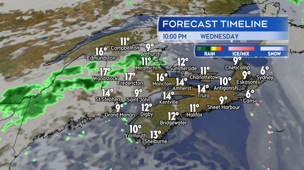
Wednesday night
Partly cloudy skies and fog patches are expected for much of the Maritimes Wednesday night. There will be periods of showers across the northern half of New Brunswick. In most cases the showers will produce rain totals of two-to-10 mm. There is a chance isolated downpours could produce localized rain amount of 10-to-30 mm. A few thunderstorms may develop Wednesday afternoon in the state of Maine and there is a low chance they could drift towards western New Brunswick Wednesday evening.
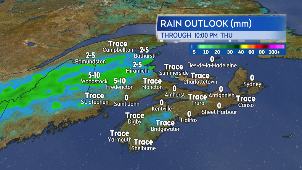 The showers will produce some rain totals of two to 10 mm. There is a chance of higher amounts in localized downpours. (Source: CTV News)
Thursday
There will be a showery start to the day for northern New Brunswick. The rest of the Maritimes will have fog patches dissipating in the morning followed by a mix of sun and cloud. Thursday afternoon will see some scattered showers develop for southern New Brunswick and the interior of mainland Nova Scotia. There is a low risk a few small thunderstorms could develop along with those showers. Those pop-up showers will end Thursday evening.
Thursday will be warm with highs ranging from the high-teens and low-twenties. There are exceptions for areas directly on the coast, which could top out in the low-to-mid teens.
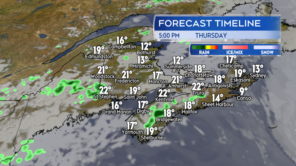 A mix of sun and cloud on Thursday. Spotty showers are expected in New Brunswick and the interior of Nova Scotia. (Source: CTV News)
Long range outlook
Weather in the Maritimes will largely be characterized by a mix of sun and cloud and near-to-above normal temperatures Friday through the weekend. Average high temperatures for the Maritimes in mid-May range the mid-to-high teens with overnight lows in the low-to-mid single digits.
Remember to mind provincial and municipal burning restrictions as the fire danger index is expected to reach the moderate-to-high range for a few spots in the region Thursday and Friday. Afterwards the forecast has it falling back to the low-to-moderate range across the Maritimes on the weekend. Provincial burning restrictions are usually updated at 2 p.m.


CTVNews.ca Top Stories

'There's mom and dad's house': New video appears to show destruction of Jasper neighbourhood
Video posted to social media on Thursday morning appears to show the charred remains of a Jasper, Alta., neighbourhood.
LIVE UPDATES
LIVE UPDATES Multiple homes, businesses 'lost' to wildfire in Jasper National Park: Parks Canada
Officials from Parks Canada and Jasper say "multiple structures, including a number of businesses and homes, in and around the town of Jasper, have been lost" to wildfire in Jasper National Park.
Alberta premier says a third, perhaps half, of all Jasper buildings destroyed by fire
Alberta Premier Danielle Smith says early reports indicate a third and perhaps up to half of all buildings in the historic Rocky Mountain resort town of Jasper have been destroyed in a wildfire.
Prince William's 2023 salary revealed in new report
Newly released financial reports show that William, the Prince of Wales, drew a salary of $42.1 million last fiscal year, his first since inheriting the vast and lucrative Duchy of Cornwall.
Canada to bring home fewest Olympic medals since 2012, according to forecaster
Fewer Canadians are expected to reach the Paris podium than in the previous two Olympic Summer Games, a global data analytics company predicts.
Former judge with disputed Cree heritage likely has Indigenous DNA: law society
The Law Society of British Columbia says a DNA test shows a former judge and Order of Canada recipient accused of falsely claiming to be Cree "most likely" has Indigenous heritage.
Tourist suffers 3rd-degree burns to feet after losing flip flops amid soaring temperatures in Death Valley
A tourist was hospitalized after suffering serious burns on his feet on Saturday when he lost his flip flops at a U.S. national park where temperatures soared past 48 Celsius.
Jennifer Aniston criticizes JD Vance for 'childless cat ladies' remarks: 'I pray that your daughter is fortunate enough to bear children'
Jennifer Aniston is criticizing JD Vance for comments he made in his past about women without children.
'Skibidi Toilet:' If you don't know what it is, you will
'Skibidi Toilet' is already an internet sensation and now its about to get even more exposure after the YouTube series is being developed for TV and film, according to a report by Variety.
Shopping Trends
The Shopping Trends team is independent of the journalists at CTV News. We may earn a commission when you use our links to shop. Read about us.


Toronto
-

Police identify man and woman killed in quadruple shooting in Toronto
Toronto police have now identified the two victims killed in a quadruple shooting in Scarborough, Ont. early Wednesday morning.
-
Man critically injured in 3-vehicle collision in Etobicoke
A man has been critically injured in a three-vehicle collision in north Etobicoke.
-
New details emerge in wrong-way crash on Hwy. 401 that killed baby and grandparents
Durham Regional Police have confirmed new details about a deadly wrong-way crash on Highway 401 which claimed the lives of a baby and his grandparents following a police chase in April.
Calgary
-

Calgary events cancelled, altered amid air quality advisory
An air quality advisory was issued for Calgary Thursday, as wildfire smoke engulfed the city.
-
Calgary reception centre to remain open for 48 hours to support wildfire evacuees
Calgary Mayor Jyoti Gondek says the city's reception centre for Jasper wildfire evacuees will remain open for the next 48 hours.
-
LIVE UPDATES
LIVE UPDATES Multiple homes, businesses 'lost' to wildfire in Jasper National Park: Parks Canada
Officials from Parks Canada and Jasper say "multiple structures, including a number of businesses and homes, in and around the town of Jasper, have been lost" to wildfire in Jasper National Park.
Edmonton
-
 LIVE UPDATES
LIVE UPDATES Multiple homes, businesses 'lost' to wildfire in Jasper National Park: Parks Canada
Officials from Parks Canada and Jasper say "multiple structures, including a number of businesses and homes, in and around the town of Jasper, have been lost" to wildfire in Jasper National Park.
-
Alberta premier says a third, perhaps half, of all Jasper buildings destroyed by fire
Alberta Premier Danielle Smith says early reports indicate a third and perhaps up to half of all buildings in the historic Rocky Mountain resort town of Jasper have been destroyed in a wildfire.
-
'Now lost': Jasper fire torching cherished memories along with forests
Social media was awash Thursday with memories of Jasper proposals, weddings and honeymoons. But the town is steeped in memory of all kinds.
Montreal
-

3 tornadoes confirmed as truck toppled, trees uprooted south of Montreal
A tornado overturned a truck and uprooted several trees in Brossard on Montreal's South Shore.
-
Laurentians municipality mulls banning wakesurfing
Public consultations have been launched on a draft bylaw in Saint-Adolphe-d'Howard that would prohibit wake boats from Lac Saint-Joseph and neighbouring Lac Sainte-Marie.
-
Persistent flooding angers Town of Mount Royal residents
In the Town of Mount Royal (TMR), several households have been suffering from persistent flooding following torrential downpours.
Ottawa
-

Storms cause significant damage in Cornwall, Ont.
A series of powerful storm cells swept across areas of Ontario on Wednesday, hitting parts of Cornwall, Ont. -- particularly hard.
-
Tornado near Perth, Ont. during severe weather on Wednesday, Northern Tornadoes Project says
Western University's Northern Tornadoes Project says a tornado touched down near Perth, Ont. Wednesday night, as a series of severe storms moved across eastern Ontario.
-
Hwy. 417 will be closed this weekend for Preston Street bridge replacement. Here's what you need to know
A stretch of Highway 417 through Ottawa will be closed for 82 hours this weekend for the replacement of the aging Preston Street overpass. CTVNewsOttawa.ca looks at what you need to know about the Queensway closure for the replacement of the Preston Street bridge.
London
-

$1.3-million drug bust by London police
On July 16, police from the guns and gangs section arrested two people after using warrants on two vehicles and a home in Eclipse Walk.
-
Suspect arrested after police said witness to crime was stabbed
On Wednesday, officers were told the suspect wanted in relation to Tuesday's incident may be in the 500 block of Ridout Street near Dufferin Avenue.
-
Goderich readying itself for 'big dig' and big changes on the square
At this point next year, Goderich's downtown will be under construction.
Barrie
-
Ont. mayor fires back at 'misinformation' about people defecating on beach
Wasaga Beach's mayor is firing back at unverified claims circulating on social media that people are defecating in the sand at the provincial park.
-
Loose wheel hits 4 vehicles on Highway 400 in Innisfil
Four vehicles sustained damage while travelling along Highway 400 in Innisfil Thursday morning after a wheel came loose.
-
Fire officials alarmed by trend of suspected arson in under-construction homes
The Ontario Association of Fire Chiefs is sounding the alarm on a recent trend involving what's believed to be the intentional destruction of new builds.
Northern Ontario
-

Worker killed at New Gold mine in northwestern Ont.
An employee operating a piece of equipment in an open pit was killed Wednesday at New Gold's gold mine in Rainy River.
-
'I'm so broke': Two Toronto women speak out after losing $76,000 in romance scam
Two women from the Toronto area are speaking out after losing thousands of dollars to a romance scam, including a single mother who lost $62,000.
-
Greater Sudbury warns of parking ticket text scam
If you recently received a text warning about an overdue parking ticket in Greater Sudbury, it's fake.
Kitchener
-

Home invasion shooting in Cambridge leads to 3 arrests and serious injuries: WRPS
The Waterloo Regional Police Service (WRPS) have arrested three males, including one teen, in connection to a home invasion shooting on Wednesday night that left multiple people injured.
-
Steven Lorentz hoists the Stanley Cup at Kitchener, Ont. cancer centre
Patients at the Grand River Regional Cancer Centre got a special treat, when Steven Lorentz stopped by the Stanley Cup.
-
New charges related to 2023 murder of Guelph man
Four people are facing new charges in connection to a homicide investigation that started nine months ago.
Windsor
-
 EXCLUSIVE
EXCLUSIVE Newborn data allegedly accessed by doctor seeking profit
The joy and excitement of welcoming a new baby has been marred for a Belle River mom, who says she’s “disturbed” to learn a doctor looking to profit targeted her newborn.
-
Shed fire causes $300,000 damage
Chatham-Kent firefighters were called to a working structure fire on Thursday.
-
City investing $2.24 million in 16 residential road projects
Some residential roads are getting a facelift.
Winnipeg
-

Boys, including nine-year-old, arrested following break and enter, arson: Winnipeg police
Five boys, including a nine-year-old, have been arrested following a break-and-enter and an arson in the West End early Thursday morning.
-
Here are the Manitobans receiving the province's highest honour
Two doctors on the frontline of Manitoba's COVID-19 fight, a long-serving MLA and the chair of the Truth and Reconciliation Commission are all receiving Manitoba's highest honour Thursday afternoon.
-
Driver caught going 202 km/h on Perimeter Highway: Winnipeg police
A driver has been fined and had his licence suspended after allegedly racing another vehicle on the Perimeter Highway on the weekend.
Regina
-

Regina crime rate increases slightly, ranks ninth in country: Stats Can
An annual report from the Canadian Centre for Justice Statistics (CCJS) shows Regina’s crime rate increased slightly from 2022 to 2023.
-
Amazing Race Canada teams to head to Regina in upcoming episode
The upcoming episode of the Amazing Race Canada will have the teams touching down in Regina.
-
Moose Jaw man charged with trafficking guns, lying to officers
Police in Moose Jaw have laid charges following a more than year-long investigation involving firearms trafficking in the city.
Saskatoon
-

'It was like torture': Saskatoon mother is relieved her son's accused killer is locked up
A Saskatoon mother says she feels a “little bit better” knowing that police caught her son’s accused killer.
-
Sask. police renew calls for information in 44-year-old missing person case
The Prince Albert Police Service (PAPS) is renewing calls for information in the disappearance of Robert Wiggins 44 years ago.
-
'A bright light': Trevor LaPlante identified as Prince Albert homicide victim
Prince Albert is grieving the loss of one of its most beloved neighbours and community champions.
Vancouver
-

Woman killed in Maple Ridge identified as IHIT appeals for information
Homicide investigators have identified a woman who was killed in Maple Ridge last weekend in what they say was an "isolated incident."
-
Driver will not be charged in crash that killed municipal worker near Victoria
An elderly woman who struck and killed a 52-year-old father who was working in a construction zone near Victoria last year will not face criminal charges in the case, authorities announced Thursday.
-
Victim of fatal Surrey stabbing identified, suspect still at large, IHIT says
Homicide investigators have shared the identity of the man fatally stabbed in Surrey Tuesday night in hopes of furthering their investigation.
Vancouver Island
-

Driver will not be charged in crash that killed municipal worker near Victoria
An elderly woman who struck and killed a 52-year-old father who was working in a construction zone near Victoria last year will not face criminal charges in the case, authorities announced Thursday.
-
Fire numbers fall in B.C. as fire near Golden destroys structures, spurs evacuation
Three employees at Canadian Timberframes near Golden, B.C., had no warning when a nearby wildfire jumped the Columbia River and "barrelled through" as many as five nearby homes, the company's co-owner said.
-
Can B.C.'s southern resident orcas be taken off the path to extinction?
The southern resident killer whale known as Tahlequah captured global sympathy in 2018 when she pushed the body of her dead calf for more than two weeks in waters off British Columbia's south coast.
Kelowna
-

Kamloops RCMP officer charged with assault, mischief
A Kamloops Mountie has been charged with assault and mischief in connection to an incident that occurred last summer, Crown prosecutors announced Wednesday.
-
2 dead after serious crash on Highway 1 in B.C. Interior
Two people are dead after a serious crash that shut down Highway 1 near Sorrento, B.C. Saturday morning.
-
Structures lost to Shetland Creek wildfire as more heat, thunderstorms strike parts of B.C.
The number of wildfires in British Columbia has flared as more lightning storms bring the potential for further fire starts.


