Thunderstorm risk in the Maritimes on Tuesday
Late morning into early afternoon saw a cluster of thunderstorms move through western and central areas of New Brunswick on Tuesday. The thunderstorms came with a severe thunderstorm watch. Along with producing frequent lightning, the thunderstorms produced downpours with rain rates approaching 25 mm/hr.
There is further risk of thunderstorms in the Maritimes Tuesday afternoon and evening.
The highest chance of more thunderstorms remains in New Brunswick. There is a lower risk of thunderstorms for Nova Scotia and Prince Edward Island. Any thunderstorms that develop in those provinces will be more isolated in coverage. The greatest hazards with any thunderstorm will be lightning and downpours.
It is also possible there could be some isolated thunderstorms in New Brunswick Tuesday overnight into early Wednesday morning.
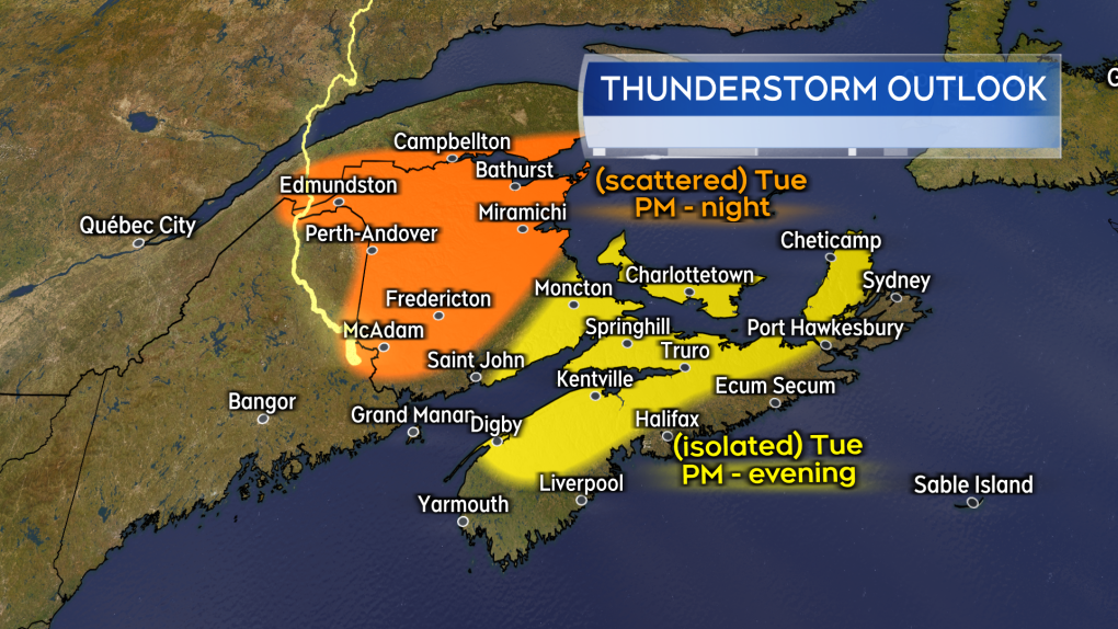 A risk of further thunderstorms in the Maritimes on Tuesday. The chance of a thunderstorm is highest in New Brunswick. (Source: CTV News Atlantic)
High humidity continues
Increased cloud cover kept temperatures Tuesday morning a touch cooler compared to Monday. As the sun starts to break through in the afternoon, the combination of heat and humidity will be felt again. Humidex values are once again expected to reach the mid-30s to near 40. Heat warnings remain in place for most areas, though they have ended for the counties of Digby, Yarmouth, and Shelburne in southwestern Nova Scotia.
It will be sunnier and hotter again for Wednesday. Expect the heat warnings to continue for most areas for at least one more day.
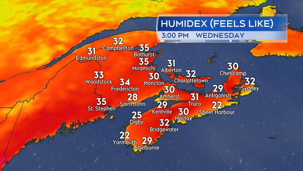 More hot and humid weather expected for most areas on Wednesday. (Source: CTV News Atlantic)
Late week cold front
A cold front passing across the Maritimes Thursday into Friday morning is expected to lower the humidity behind it.
Dew point temperatures – a measure of moisture in the air – should fall into the low-to-mid teens across the Maritimes for Friday afternoon. For most there will be a more comfortable feel to the air.
There will still be warm-to-hot July weather for Friday and the weekend. Most communities can still expect high temperatures to reach the mid-to-high 20s. The lower level of humidity in the air will help relieve the high humidex values we are experiencing through the start of this week.
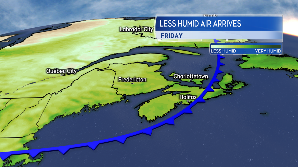 A cold front passing across the Maritimes late this week will have less humid air come in behind it. (Source: CTV News Atlantic)


CTVNews.ca Top Stories

Labour board orders rail workers back on the job as Teamsters vow to appeal
Freight trains must start rolling again first thing Monday morning, the federal labour board ruled Saturday as it ordered thousands of rail employees back to work to end a bitter contract dispute that shut down the country's two major railways.
Commercial truck plunges off bridge in B.C. Interior, driver unaccounted for, RCMP say
The driver of a semi truck and trailer that plunged off of a bridge in the B.C. Interior Saturday morning has not been located, according to police.
'Bank investigator' fraud spreading in eastern Ontario: What it is and how to avoid it
Ontario Provincial Police and the Canadian Anti-Fraud Centre are warning people about fraudsters impersonating major Canadian banks.
Brother-in-law of man allegedly swarmed by teens says family reeling from loss
The brother-in-law of a homeless Toronto man who died after police allege he was attacked by a group of teen girls says his entire family is reeling from the loss.
Chappell Roan's comments about invasive fans show that we never really know our favourite celebrities
Sudden fame has weighed heavy on Chappell Roan, but her discomfort became untenable earlier this week. She shared two videos on TikTok in which she criticized invasive fans who have followed her around, 'stalked' her family and demanded photos or hugs in public despite Roan's resistance.
'We have won': Kenyan man granted temporary residency day before deportation order
One day before he was set to be deported to Kenya, Charles Mwangi was granted temporary residency.
Major Canadian rental company warns tenants that hackers may have their banking info
One of western Canada’s largest rental property companies is warning tenants about a cyber security breach it says was discovered earlier this year.
German police arrest suspect in stabbing rampage, official says
A man suspected of a stabbing rampage in the western German town of Solingen has been taken into police custody, a state official told German television on Saturday, some 24 hours after the attack that killed three people.
OPINION
OPINION The dark side of frugality: When saving becomes an obsession
Is being frugal pushing you over the edge? Personal finance contributor Christopher Liew explains some of the downsides of obsessive frugality and offers some tips on how to balance frugal living with living your daily life.
Shopping Trends
The Shopping Trends team is independent of the journalists at CTV News. We may earn a commission when you use our links to shop. Read about us.


Toronto
-

'We have won': Kenyan man granted temporary residency day before deportation order
One day before he was set to be deported to Kenya, Charles Mwangi was granted temporary residency.
-
Motorcyclist sought after Toronto cop seriously injured in hit-and-run
A Toronto police officer has been seriously injured after being struck by a motorcyclist near Rogers Centre.
-
Search continues for man wanted for murder in deaths of two female relatives in Etobicoke
Toronto police continue to look for a 33-year-old man wanted for murder in connection with the deaths of his two female relatives.
Calgary
-

$10,000 reward offered for the capture of murder suspect Elijah Blake Strawberry
Alberta Mounties have authorized a $10,000 reward for information leading to the arrest of the fugitive Elijah Blake Strawberry.
-
Mayor Jyoti Gondek wants Calgary at forefront of worldwide energy transition
Mayor Jyoti Gondek has been named vice president of the World Energy Cities Partnership; a role she believes will encourage global companies to explore ways Calgary can be part of their energy plans.
-
Western Canadian pin collectors gather in Calgary to trade, buy and sell
Pin collecting, like any hobby, starts off with just one; but often leads to hundreds as interest and enthusiasm to find something unique grows.
Edmonton
-

'Butter, crayfish, salt': How you can take advantage of an urban crustacean invasion
If you're looking for fresh shellfish in Edmonton, you need not look further than the North Saskatchewan River.
-
Blackfalds mother hits dead end after daughter's busing application rejected
A mother in Blackfalds, Alta. has to find a new way to get her nine-year-old daughter to school after guidelines set by the province made her ineligible for busing.
-
Major Canadian rental company warns tenants that hackers may have their banking info
One of western Canada’s largest rental property companies is warning tenants about a cyber security breach it says was discovered earlier this year.
Montreal
-

Start applying for English eligibility certificates sooner rather than later: EMSB
With the start of the new school year quickly approaching, many are wondering about the eligibility certificate and whether their family needs one. The answer is simple: if you want to enrol your child in an English elementary or high school in Quebec, they will need one.
-
Tugboats free grounded cargo ship blocking traffic in St. Lawrence Seaway
A stuck 138-metre cargo ship that had been blocking traffic in the St. Lawrence Seaway near Montreal has been freed.
-
Dozens of baby turtles set free in Quebec river as part of zoo conservation project
Dozens of endangered baby spiny softshell turtles are being released into a southern Quebec river today as part of a project to help save the species.
Ottawa
-

'Watch for kids, buses': OPP sharing safety tips as students go back to school
It’s the time of year when kids go back to school and police in eastern Ontario are sending reminders to drivers and parents on how to keep children safe.
-
Two tornadoes confirmed during storms southeast of Ottawa Wednesday
Scientists with Western University's Northern Tornadoes Project (NTP) confirm two tornadoes touched down in eastern Ontario towns on Wednesday, with one causing some minor damage.
-
Labour board orders rail workers back on the job as Teamsters vow to appeal
Freight trains must start rolling again first thing Monday morning, the federal labour board ruled Saturday as it ordered thousands of rail employees back to work to end a bitter contract dispute that shut down the country's two major railways.
London
-

London Brewery packed as Home County Music Festival returns for one-day event
It may not exactly look the same, but the Home County Music and Art Festival (HCMAF) is back.
-
Chatham-Kent Crime Stoppers to hold free fingerprint and car seat clinic in September
Parents are invited to solve some safety anxiety next month.
-
‘Filling a truck with menstrual products’: Collection happening at Wortley on the Green Saturday
A London charity has a goal of filling an entire U-Haul truck with menstrual products Saturday afternoon.
Barrie
-

Big crowds turn out for annual Rama First Nation Powwow
In celebration of culture and community, an annual powwow drew thousands to the Rama First Nation this weekend.
-
Police search for suspect in early morning robbery investigation
Investigators have released images of a suspect connected to an early morning robbery in Gravenhurst.
-
Pedestrian struck in fail-to-remain overnight crash
Police are investigating an overnight fail-to-remain collision after a pedestrian was struck in Midland.
Northern Ontario
-
Labour board orders rail workers back on the job as Teamsters vow to appeal
Freight trains must start rolling again first thing Monday morning, the federal labour board ruled Saturday as it ordered thousands of rail employees back to work to end a bitter contract dispute that shut down the country's two major railways.
-
Surge in stabbings in Sudbury linked to personal disputes, drugs and alcohol
There has been a sudden increase in stabbing attacks in Greater Sudbury in recent days.
-
Hwy. 17 reopens after crash near Espanola
The Ministry of Transportation's 511 Traveller Information Service says Highway 17 has reopened after being closed Saturday afternoon due to a collision.
Kitchener
-

Waterloo Region embraces inaugural Caribana Ignite street party
For the first time in its 50-year history, Caribana made its way outside of Toronto, and the Kitchener community welcomed it with open arms.
-
Body found in Ont. identified as B.C. woman who went missing 19 years ago
A body discovered in a wooded area near Rockwood, Ont. has finally been identified as a missing British Columbia woman.
-
Neighbours disgusted by Nazi flag at Kitchener, Ont. home
Residents living in a Kitchener, Ont. neighbourhood are speaking out about a Nazi flag that was seen flying outside a home on their street.
Windsor
-

Former Sears employees reunite for parking lot BBQ as demolition of Devonshire Mall 'landmark' continues
With the backdrop of concrete rubble amid ongoing demolition, former employees of the Sears store in Devonshire Mall — which closed in 2018 — joined together to reminisce about the glory days of working there.
-
VIDEO
VIDEO Young drivers share innovative ideas to combat distracted driving at road safety event
With distracted driving posing a serious threat to the safety of both motorists and pedestrians, young drivers are sharing their ideas on how to reduce road collisions and fatalities related to it.
-
Chatham-Kent Crime Stoppers to hold free fingerprint and car seat clinic in September
Parents are invited to solve some safety anxiety next month.
Winnipeg
-

Manitoba staple snacks marking milestone anniversaries
Two Manitoban snacking staples – Old Dutch Ltd. and Mordens’ are celebrating a combined 135 years in business in Winnipeg.
-
6 people evacuated from house fire in Winnipeg’s Spence neighbourhood
Six people were evacuated from a home in Winnipeg’s Spence neighbourhood after a fire in the 600 block of Furby Street.
-
Broken elevator leaves Steinbach residents ‘trapped’ in suites
Some tenants in an affordable housing building in Steinbach, Man., are having trouble accessing their suites because of a broken elevator.
Regina
-

Lumsden winery holds annual Ladybug Picnic Festival in support of Mother Baby Unit
The Over the Hill Orchards & Winery hosted their 2nd annual Ladybug Picnic Festival over the weekend.
-
This hitchhiking lobster has made his way to Saskatchewan
Lucky the hitchhiking lobster has made his way to Saskatchewan. The stuffed toy lobster has created a social media trail across Canada as it travels home.
-
Police launch investigation after woman found dead in Regina home
Police have launched an investigation after a woman was found dead in a Regina home on Friday night.
Saskatoon
-

Sask. woman faces murder charge after man dies
A 35-year-old woman from the RM of Corman Park has been charged with first-degree murder in connection with the death of a man.
-
Saskatoon hit by overnight flooding, traffic disrupted
Overnight storms and intense rainfall brought flooding to several areas of Saskatoon, causing traffic disruptions.
-
Three injured after vehicle crashes into Saskatoon house
Three people were sent to hospital after a single vehicle crashed into a house in Saskatoon Saturday morning.
Vancouver
-

Light Up Chinatown festival returns to Vancouver
For the fourth year in a row, the Light Up Chinatown festival is bringing food and entertainment to the historic Vancouver neighbourhood.
-
Commercial truck plunges off bridge in B.C. Interior, driver unaccounted for, RCMP say
The driver of a semi truck and trailer that plunged off of a bridge in the B.C. Interior Saturday morning has not been located, according to police.
-
B.C. businessman committed civil fraud, must pay company $72K, court rules
A B.C. man and his company have been ordered to pay more than $72,000 after a judge found he had breached his fiduciary duty and committed civil fraud.
Vancouver Island
-

Weekend rain dampening B.C. wildfire activity as active blazes numbers drop
Rain and cool weather in southern British Columbia is dousing wildfire activity in the province, but firefighters are urging vigilance despite the drop in the number of active blazes.
-
Watchdog clears police of criminal offences in handling of Lumby, B.C., death
British Columbia's police watchdog group has closed its investigation of a woman's death in April in Lumby, B.C., saying it did not find any evidence of a criminal offence in officers' handling of the case.
-
Labour board orders rail workers back on the job as Teamsters vow to appeal
Freight trains must start rolling again first thing Monday morning, the federal labour board ruled Saturday as it ordered thousands of rail employees back to work to end a bitter contract dispute that shut down the country's two major railways.
Kelowna
-

Commercial truck plunges off bridge in B.C. Interior, driver unaccounted for, RCMP say
The driver of a semi truck and trailer that plunged off of a bridge in the B.C. Interior Saturday morning has not been located, according to police.
-
Merritt, B.C., emergency room closing for 25 hours this weekend
The emergency department at Nicola Valley Hospital and Health Centre in Merritt is once again closed due to limited physician availability.
-
Man charged with mischief for allegedly starting several fires Vernon, B.C.
A 33-year-old man is facing multiple charges for allegedly setting several fires in Vernon on Monday.


