Rain and thunderstorms moving east; wind to ease Tuesday night in the Maritimes
Rain clears
Rounds of rain and showers will continue to move eastward across the Maritimes heading into Tuesday evening. The last of the rain is expected to clear Cape Breton by late evening. Cloudy periods and patchy drizzle and fog will follow for the night and Wednesday morning.
The highest chance of rain totals ranging 10 to 30 mm remains in western New Brunswick and the Atlantic coastal areas of Nova Scotia. Much of the remainder of the Maritimes can expect two to 10 mm. The wet weather and higher humidity is lowering the fire danger risk for the region, now rated as low-to-moderate by Natural Resources Canada.
 Varied rain totals for the Maritime region. Some have as much as 10 to 30 mm, while other areas will likely finish with 10 mm or less.
Risk of thunderstorms
The highest risk of thunderstorms Tuesday afternoon and evening will be in two areas of the Maritimes. The first area will be Atlantic coastal Nova Scotia. Embedded thunderstorms are present in the band of rain moving through. In some cases, those thunderstorms could bring brief, localized downpours.
The second area at risk of thunderstorms will be northwestern New Brunswick. There, the risk of thunderstorms will extend into mid-evening. As of noon Tuesday, no severe thunderstorm watches or warnings were in effect.
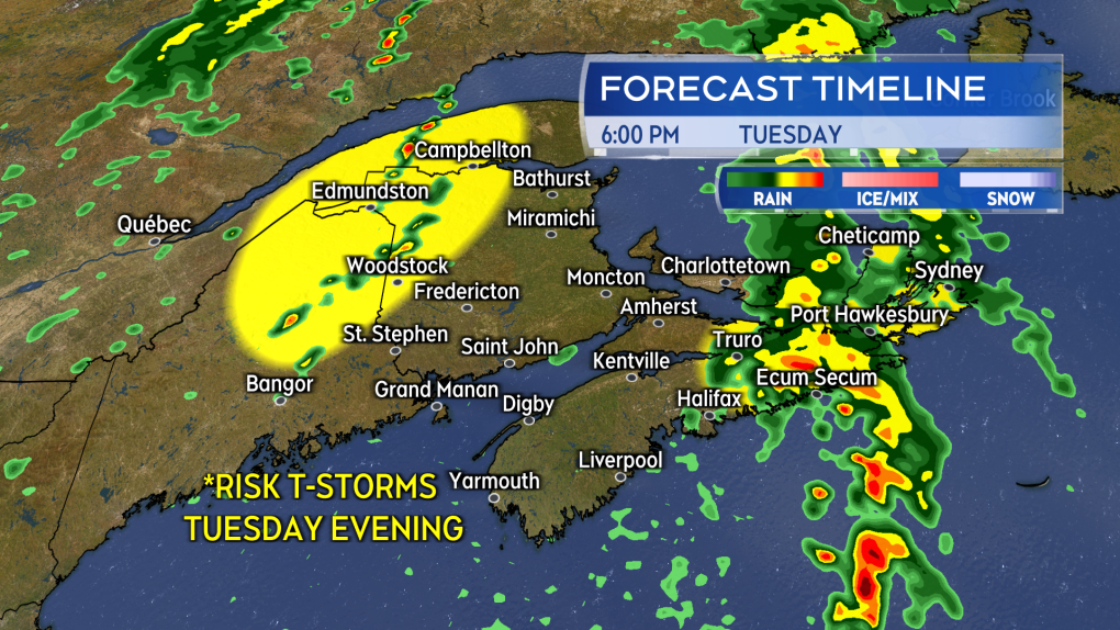 Rain is expected with a risk of thunderstorms in eastern Nova Scotia Tuesday evening. Northwestern New Brunswick could also see some thunderstorms develop Tuesday afternoon into evening.
Wind eases
A gusty southerly wind has accompanied the wet weather on Tuesday. Stronger gusts of 80 to 100 km/h are being reported in northern Inverness County, Cape Breton. The area is under a wind warning. Wind for the entirety of the Maritimes will turn southwest and diminish Tuesday evening and night. The wind remains southwest for Wednesday and will be blustery with gusts ranging 30 to 50 km/h.
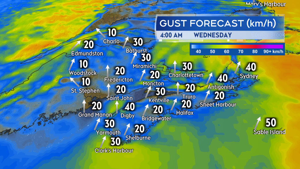 A south/southwest wind with gusts diminishing into a range of 20 to 40 km/h is expected Tuesday night into early Wednesday morning.
I’ll have the latest on any active thunderstorms in the region, regional weather conditions, and forecast updates on CTV News Atlantic 5, 6, and 11:30 p.m.


CTVNews.ca Top Stories

Canadian Olympic Committee offers 'heartfelt apology' after New Zealand accuses Canada Soccer of spying
The Canadian Olympic Committee offered a 'heartfelt' apology to New Zealand Football Tuesday after the New Zealand women's club accused the Canadian women's team of spying on them during a training session.
Jasper evacuees forced into B.C. to flee fires told to make U-turn to Alberta for aid
Thousands of wildfire evacuees forced from Jasper National Park into British Columbia along smoke-choked mountain roads Monday night were directed Tuesday to make a wide U-turn and head home if they needed a place to stay.
Pennsylvania state police commissioner reveals stunning details about Trump shooting
A local law enforcement commissioner revealed during a House Homeland Security hearing on Tuesday stunning new details about the security failures that led to the near assassination of Donald Trump, raising more questions for the embattled U.S. Secret Service.
Sunday was the hottest day ever recorded on Earth, scientists say
Sunday was the hottest day ever recorded, breaking global temperatures dating back to 1940, according to preliminary data from Europe's Copernicus Climate Change Service.
Polar bear at Calgary Zoo died by drowning following 'crushing' injury
The Wilder Institute/Calgary Zoo has revealed the cause of death for polar bear Baffin last week.
Clip resurfaces of Vance criticizing Harris for being 'childless,' testing Trump's new running mate
Comments Donald Trump’s running mate JD Vance made in 2021 questioning U.S. Vice President Kamala Harris’ leadership because she did not have biological children have resurfaced, testing the young conservative senator in his early days campaigning as part of the Republicans' presidential ticket.
Premier says fine-tuning needed for alert system after miscommunicated Jasper evacuation timing
Alberta's premier says changes are needed to the province's emergency alert system after incorrect information was shared about the Jasper evacuation on Monday night.
'I had to go into hiding': Manitoba man still being harassed after charges into alleged human trafficking ring dropped
A man whose charges were stayed following an investigation into an alleged child sex trafficking ring in Portage la Prairie says his life has been ruined.
'Stars are aligning' for Bank of Canada rate cut: economists
The Bank of Canada is expected to deliver a dose of interest rate relief Wednesday when economists and market watchers predict the central bank will cut its overnight lending rate.
Shopping Trends
The Shopping Trends team is independent of the journalists at CTV News. We may earn a commission when you use our links to shop. Read about us.


Toronto
-

'Heartbreaking': Bike used for cancer fundraising stolen from Toronto woman's basement
A Toronto woman is looking to recover the specialized bicycle used to raise money for cancer research after it was stolen from her Etobicoke home over the weekend.
-
'That is chilling': New Zealand man says Canadian regulators, e-commerce platforms should have protected his late brother
The brother of a New Zealand man who died after ordering a product from an accused Canadian suicide salesman says it shouldn’t be so easy for vulnerable people to get dangerous substances online.
-
SIU called in after man shot by Toronto police officer in Cabbagetown
Toronto police say an officer shot a man armed with a knife in Cabbagetown.
Calgary
-

Calgary moves to Stage 1 outdoor water restrictions
Calgary is now under Stage 1 outdoor water restrictions, effective immediately. Mayor Jyoti Gondek made the announcement on Tuesday afternoon.
-
Polar bear at Calgary Zoo died by drowning following 'crushing' injury
The Wilder Institute/Calgary Zoo has revealed the cause of death for polar bear Baffin last week.
-
Calgary opening reception centre for Jasper wildfire evacuees
Calgary is opening a reception centre for evacuees fleeing a wildfire near Jasper National Park.
Edmonton
-

Premier says fine-tuning needed for alert system after miscommunicated Jasper evacuation timing
Alberta's premier says changes are needed to the province's emergency alert system after incorrect information was shared about the Jasper evacuation on Monday night.
-
Jasper evacuees forced into B.C. to flee fires told to make U-turn to Alberta for aid
Thousands of wildfire evacuees forced from Jasper National Park into British Columbia along smoke-choked mountain roads Monday night were directed Tuesday to make a wide U-turn and head home if they needed a place to stay.
-
Camp reservations in Jasper National Park cancelled after wildfire evacuation
Camping reservations in Jasper National Park have been cancelled for two weeks due to the ongoing evacuation in the area.
Montreal
-

Residents of townhouse development say they bought homes because of the surrounding greenspace, now it's being destroyed
A group of residents in a Sainte-Anne-de-Bellevue townhouse development say they thought they were living in a protected greenspace until bulldozers came in. Now they claim they bought something the builder couldn't deliver.
-
Police say teen wanted in West Island homicide escaped from custody
Montreal police say a youth who was arrested in connection with the killing of a 42-year-old man in the West Island last February has escaped from custody in Ontario
-
Two women in serious condition after collision in Montreal
Two young women are in critical condition following a collision between their electric scooter and a car on Tuesday afternoon in the West Island, according to Montreal police (SPVM).
Ottawa
-

'We can do better': Conversation on tent-like structures to house asylum seekers heats up
Alta Vista and Barrhaven neighbourhoods are now being shortlisted as possible candidates for the installation of a tent-like 'sprung structure' to house asylum seekers, but a local councillor says the city can do better.
-
Here's where 20 new photo radar cameras will be installed in Ottawa this summer and fall
Work is underway to install 20 new photo radar cameras across the City of Ottawa, as the city continues to expand the automated speed enforcement program.
-
Plan proposes building one of Ottawa's tallest residential buildings in Barrhaven
The City of Ottawa has received an application to build two high-rise, mixed-use towers at the corner of Marketplace Avenue and McGarry Terrace, near Strandherd Drive, and a 440 sq. m. publicly accessible courtyard.
London
-

Young man pleads guilty to impaired causing death in crash that killed 11-year-old St. Thomas boy
For the first time since losing their 11-year-old son, the family of Aiden Curtis of St. Thomas got a look at the man who caused his death.
-
Downtown London robbery ends in witness being stabbed
Early this afternoon, a man entered a business in the area of Richmond Street and Oxford Street East, and left without paying for items that he picked up inside. He was confronted by a member of the public, who was stabbed.
-
Feature film 'Falsehood' being shot in director's hometown of London
It was a taste of Hollywood North in downtown London on Tuesday as a hometown boy wrapped up shooting a feature film outside Budweiser Gardens along Talbot Street.
Barrie
-

Midland homicide victim met suspect on dating app, family says
Julia's family is holding a visitation Monday night in Ajax. They say they plan to have a celebration of life sometime next week at Sand Banks Provincial Park.
-
Man, 79, dies after being struck by dump truck
York Regional Police are investigating a fatal collision involving a pedestrian and a dump truck early Tuesday morning.
-
Allegedly impaired driver crashes into Hwy 400 guardrail, keeps driving
A young driver faces charges after police received reports about a vehicle slamming into the guardrail along Highway 400 Tuesday morning and driving off.
Northern Ontario
-

Sudbury man gets three years in prison in historical sexual assault case
A Sudbury man has been sentenced to three years in prison after being found guilty of sexual assault in connection with a threesome in 2013 but doesn't have to register as a sex offender.
-
Thunder Bay, Ont., police officer charged with assault causing bodily harm
The director of Ontario’s Special Investigations Unit has charged a Thunder Bay Police officer with a criminal offence in connection with an incident on June 30, 2023.
-
Sex assault suspect was a therapist for child and family services in North Bay, Ont.
A 70-year-old suspect has been charged with multiple sexual assault charges that took place while he worked for the former Algonquin Child and Family Services.
Kitchener
-

Kitchener woman hopes Ont. follows other provinces in covering rare cancer drug
Noor Ayesha from Kitchener Ont., is battling a rare and aggressive form of cancer while pushing the province to fund an expensive drug, which could extend her life.
-
Growing capacity by 500 beds: more details about new hospital in Waterloo Region
More details have been shared about the vision for the yet-to-be-named hospital.
-
Man, 58, dies after drowning in the Grand River in Glen Morris: OPP
Police are investigating after a Glen Morris, Ont. man died after reportedly drowning in the Grand River.
Windsor
-

Third time a charm for Tecumseh's Linda Morais, who is heading to Paris
“I'm hopeful she'll be bringing us back a medal,” said Tremblay, who also coached his son David Jr. and watched him wrestle at the Olympics in England in 2012.
-
Summer spike in salmonella infections: WECHU
The Windsor-Essex County Health Unit is warning the public after a drastic rise in foodborne illnesses this summer.
-
Windsor-Detroit Tunnel scam: fake toll texts target travelers
Windsor-Detroit Tunnel users are being warned of a circulating scam. According to officials, customers have reported receiving a text message claiming they owe money for tolls.
Winnipeg
-

'I had to go into hiding': Manitoba man still being harassed after charges into alleged human trafficking ring dropped
A man whose charges were stayed following an investigation into an alleged child sex trafficking ring in Portage la Prairie says his life has been ruined.
-
'We can get housing built faster': Council eliminates need for traffic studies in development applications
The City of Winnipeg is taking a step to get condos and apartment projects going faster.
-
Manitoba warns fruit growers about invasive pest
Whether you own a farm or have a backyard berry patch, the province is warning fruit growers about a tiny pest causing massive problems: the spotted wing drosophila (SWD).
Regina
-

'It affects the whole day': Regina daycares limiting time outdoors due to smoke
Regina YMCA Childcare Centres are limiting kids' time outdoors due to the wildfire smoke.
-
Province begins construction on new affordable housing units in Regina
The Government of Saskatchewan turned the sod on six new affordable housing units in Regina on Tuesday.
-
Sask. Science Centre talks 'owl' about repurposed space and feathered friend who used to live there
Patrons of the Saskatchewan Science Centre may have noticed a certain bird of prey has been missing this past year.
Saskatoon
-

'Ash was raining down': Saskatoon couple among thousands forced to flee Jasper
Multiple wildfires in Jasper National Park forced a Saskatoon couple to evacuate the park on Monday night.
-
-
Saskatchewan's year-long pediatric gastroenterologist vacancy has been filled
Saskatchewan kids with gastrointestinal issues are getting a specialist back at the Jim Pattison Children’s Hospital.
Vancouver
-
 EXCLUSIVE
EXCLUSIVE Metro Vancouver hospital turned away patients at emergency department
Patients who went to Mission Memorial Hospital’s emergency department on Tuesday evening were told to go to Abbotsford General or Maple Ridge hospitals, the first time a Metro Vancouver acute care facility has turned away patients due to critical staffing shortages.
-
The B.C. towns that jumped to help Jasper fire evacuees
Small-town B.C. has a reputation for being friendly and full of culture, but on Monday evening they showed just how quickly they can jump into action when there's a crisis in another province.
-
Highway 1 reopens amid Shetland Creek wildfire fight
A stretch of highway closed Sunday due to the out-of-control Shetland Creek wildfire has now reopened, according to local officials.
Vancouver Island
-

Wildfire spreads on southern Vancouver Island amid 'challenging' terrain
An out-of-control wildfire on southern Vancouver Island has grown to 50 hectares as firefighting crews continue to battle the blaze west of Victoria.
-
Video shows theft of 11-year-old girl's bracelets from Vancouver Island porch: RCMP
An 11-year-old girl selling handmade gemstone bracelets on her porch had most of her crafts stolen last week, according to authorities on Vancouver Island.
-
3 men randomly stabbed by stranger in downtown Vancouver: police
In less than 15 minutes, three people were stabbed in seemingly random attacks in downtown Vancouver Monday night, according to authorities.
Kelowna
-

2 dead after serious crash on Highway 1 in B.C. Interior
Two people are dead after a serious crash that shut down Highway 1 near Sorrento, B.C. Saturday morning.
-
Structures lost to Shetland Creek wildfire as more heat, thunderstorms strike parts of B.C.
The number of wildfires in British Columbia has flared as more lightning storms bring the potential for further fire starts.
-
How B.C.'s firefighting smokejumpers take 'ultra-extreme and make it seem mundane'
Standing on the edge of an open aircraft hatch, a smokejumper in a pale yellow suit steadies himself before rocking back then swinging out the door and vanishing as gravity takes over.


