Storm tracking: Hurricane Lee forecast cone extends across Maritimes
 A satellite image shows Hurricane Lee on Sept. 11, 2023.
The forecast cone for Lee now includes all three Maritime provinces. The cone represents the area through which the storm will take a probable path. The risk of stormy weather for the Maritimes continues to be Saturday and Sunday.
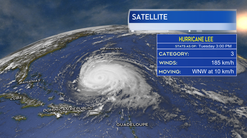 Hurricane Lee maintains a Category 3 storm Tuesday afternoon.
Due to the increased amount of uncertainty that far into the forecast for the storm, it should be noted that the cone is quite wide, measuring over 700 km in width.
In their first bulletin on Lee, the Canadian Hurricane Centre stated that “The range of track possibilities is very broad this far ahead in time, ranging from somewhere in Maine to the southeast of Nova Scotia.” The extent the centre of the storm moves through that area will determine what areas experience the worst of the weather with the storm.
For example, a pass more towards the west, into Maine, would direct the strongest of the winds Saturday into coastal Maine and the heaviest of the rain through that state and into eastern areas of Quebec. A pass of the centre of the storm into southwestern Nova Scotia would bring the most intense wind into western areas of that province and southern New Brunswick Saturday, with the heaviest rain occurring in southwestern Nova Scotia and extending into New Brunswick. A more precise path through the area will continue to be narrowed down over the coming days.
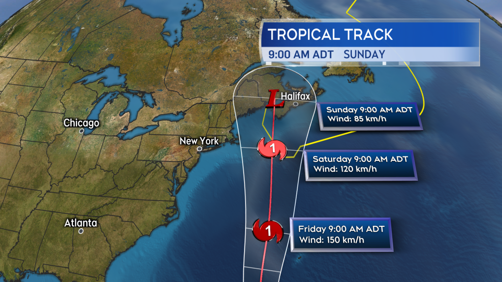 The latest forecast track from the National Hurricane Center has Lee approaching the Maritimes as a Category 1 hurricane Saturday morning.
On the plus side, as Lee moves west of Bermuda it is expected to encounter a pool of relatively cooler water that was left in the wake of the passage of Hurricane Franklin last week. That, combined with some unfavourable wind conditions, is expected to decrease the intensity of the storm with it approaching as a Category 1 hurricane – making the storm weaker than both Fiona and Dorian, which arrived as equivalent Category 2.
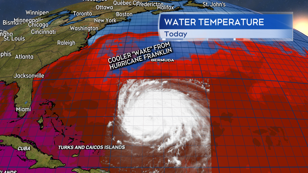 A pool of ocean water less than 26.5 degrees Celsius is present just west of Bermuda due to the passage of Hurricane Franklin. As Lee moves over that water it should work to weaken the storm.
Just because the storm may not be as intense as Fiona and Dorian, that doesn’t mean it won’t be impactful. While the intensity in the forecast may decrease, the size of the storm will actually increase. The wind and rain will diffuse outwards from the centre to encompass a very large area. The wind will still be strong enough to bring a high risk of power outages to the Maritimes. Areas that get into the heaviest rain will still have a risk of flooding and flash flooding. A rough and pounding surf will be present on parts of the coast. Travel services, such as ferries, may still be disrupted.
Additionally whether it moves more towards Maine or more directly into the Maritimes, the storm will be slow to clear the region. That means, while the worst of the weather may arrive for Saturday, some lingering impacts when it comes to gusty winds and rain are anticipated for Sunday as well.
Shopping Trends
The Shopping Trends team is independent of the journalists at CTV News. We may earn a commission when you use our links to shop. Read about us.


CTVNews.ca Top Stories

'Mayday!': New details emerge after Boeing plane makes emergency landing at Mirabel airport
New details suggest that there were communication issues between the pilots of a charter flight and the control tower at Montreal's Mirabel airport when a Boeing 737 made an emergency landing on Wednesday.
Trudeau appears unwilling to expand proposed rebate, despite pressure to include seniors
Prime Minister Justin Trudeau does not appear willing to budge on his plan to send a $250 rebate to 'hardworking Canadians,' despite pressure from the opposition to give the money to seniors and people who are not able to work.
Hit man offered $100,000 to kill Montreal crime reporter covering his trial
Montreal news outlet La Presse says a hit man offered $100,000 to have one of its crime reporters assassinated.
Cucumbers sold in Ontario, other provinces recalled over possible salmonella contamination
A U.S. company is recalling cucumbers sold in Ontario and other Canadian provinces due to possible salmonella contamination.
Trudeau says no question incoming U.S. president Trump is serious on tariff threat
Prime Minister Justin Trudeau says incoming U.S. president Donald Trump's threats on tariffs should be taken seriously.
Insurgents breach Syria's second-largest city Aleppo in shock offensive
Insurgents breached Syria's second-largest city Aleppo after blowing up two car bombs on Friday and were clashing with government forces on the city's western edge, according to a Syria war monitor and fighters.
Here's how thick ice needs to be to park a truck on it, according to Sask. Water Security Agency
The Saskatchewan Water Security Agency (WSA) says ice should be at least one foot (30 centimetres) thick before it's safe to drive a car or light truck on a frozen body of water.
Democratic lawmakers from Connecticut report Thanksgiving bomb threats against their homes
At least six Democratic members of Congress from Connecticut were targeted by bomb threats on their homes Thursday, the lawmakers or their offices said.
Latest updates: Tracking RSV, influenza, COVID-19 in Canada
As the country heads into the worst time of year for respiratory infections, the Canadian respiratory virus surveillance report tracks how prevalent certain viruses are each week and how the trends are changing week to week.
Toronto
-
 BREAKING
BREAKING Feds announce $758 million in funding for new Line 2 TTC subway trains
The TTC will get funding from the federal government to replace aging trains on Line 2, Deputy Prime Minister Chrystia Freeland has announced.
-
Highway 407 owner says no active buyback discussions with Ontario government
The provincial government is facing increasing pressure to tap into the underused and tolled Highway 407 to alleviate congestion on Highway 401.
-
Officer’s inaccurate testimony 'will undoubtedly tarnish the image of the Toronto Police Service:' police tribunal
A Toronto cop who 'derailed' a criminal investigation by 'inaccurately' testifying that he saw drugs in plain view inside a suspect’s car has been demoted for two years after pleading guilty to discreditable conduct, a decision from the police tribunal read.
Calgary
-

Calgary fighters thankful to enter ring under safe conditions after Ultra Boxing event cancelled
A group of Calgary fighters are thankful to be able to enter the ring under a properly sanctioned event this weekend after the organization they were training under was suspended by Boxing Alberta for two years due to safety concerns.
-
Calgary Mayor Jyoti Gondek running for re-election
Calgary Mayor Jyoti Gondek has announced she will run for re-election in the next municipal election in 2025.
-
Cucumbers sold in Ontario, other provinces recalled over possible salmonella contamination
A U.S. company is recalling cucumbers sold in Ontario and other Canadian provinces due to possible salmonella contamination.
Edmonton
-

Machete used to kill Edmonton man may have been picked up by passerby: police
Police are searching for the weapon used to kill an Edmonton man last month.
-
Pedestrian hospitalized after Friday morning crash in central Edmonton
A woman is in hospital with serious injuries after a crash on Friday morning.
-
Oilers to face new Utah Hockey Club after long layoff
The Edmonton Oilers will try to make it back-to-back wins when they open a three-game road trip against the Utah Hockey Club on Friday in Salt Lake City.
Montreal
-

Hit man offered $100,000 to kill Montreal crime reporter covering his trial
Montreal news outlet La Presse says a hit man offered $100,000 to have one of its crime reporters assassinated.
-
'Mayday!': New details emerge after Boeing plane makes emergency landing at Mirabel airport
New details suggest that there were communication issues between the pilots of a charter flight and the control tower at Montreal's Mirabel airport when a Boeing 737 made an emergency landing on Wednesday.
-
Quebec trying to 'minimize' impact of health care cuts on services
Eliminating $1.5 billion in health care spending is likely to have an impact on services, but Quebec says it will try to 'minimize' it.
Ottawa
-

Next big test for the LRT south extension taking place Saturday
Five hundred people will be riding on Lines 2 and 4 Saturday, to simulate passenger service in a 'dress rehearsal' that marks the next major step before the delayed south extension can open to the public.
-
Ottawa police charge two adults, teenager following Orleans kidnapping and robbery
The Ottawa Police Service says two adults and a teenager are facing multiple charges following a kidnapping, robbery and extortion incident that happened last month in Orleans.
-
'Dude, Where's My Bus?' Ottawa man fed up with OC Transpo makes documentary exploring transit troubles
Gio Petti put together a documentary on OC Transpo, asking how we got here. How did a city that was once lauded as an example of how to do transit right, and that boasted some of the highest per capita transit ridership numbers in the country, become a system that now elicits so much frustration from users?
London
-

Crown witness describes chaotic night after bush party shooting
Crown witness Reece Davidson, 21, told the jury that he was at the bush bash off of Pack Road in southwest London with a bunch of his young friends on July 30, 2021.
-
'The only thing you could see were his eyes': Employees pepper sprayed at south London business
Around 4 p.m. on Thursday, police were called to a report of an assault in progress at a business int he 600 block of Wilkins St. near Wellington Road.
-
Digging out from snow squalls in Bruce County
It’s a day for digging in Bruce County. School buses across Bruce and Grey counties were cancelled Friday due to snowsqualls that dumped as much as 15 centimetres of snow on the region overnight.
Barrie
-

50 cm of snow across central Ontario expected this weekend
Environment Canada has released snow squall warnings and watches for our region.
-
Alleged mastermind behind Ontario woman's presumed death seeks bail
The man facing first-degree murder and kidnapping charges in the disappearance of Ontario woman Elnaz Hajtamiri took another shot at bail on Friday in a Barrie courtroom. Mohamad Lilo, 37, has been behind bars since his arrest more than two years ago.
-
Two men charged with assaulting municipal law enforcement officer, one suspect at large
Two people face charges as police seek a third individual in connection with the alleged assault of a municipal law enforcement officer.
Northern Ontario
-

Man fined $10K for abandoning homemade barge in Lake Nipissing
A man from Lavigne, Ont., has been fined $10,000 for abandoning a homemade barge in Lake Nipissing.
-
Another 60 cm of snow possible in the Sault as severe weather continues
Closures and cancellations are piling up in Sault Ste. Marie as a major winter storm continues for another day Friday.
-
California man who went missing for 25 years found after sister sees his picture in the news
It’s a Thanksgiving miracle for one California family after a man who went missing in 1999 was found 25 years later when his sister saw a photo of him in an online article, authorities said.
Kitchener
-

Erick Buhr to represent himself during sentencing for second-degree murder in death of his grandmother, Viola Erb
Erick Buhr will represent himself as he prepares for sentencing after being convicted of second-degree murder in the death of his grandmother, Viola Erb.
-
Man accused of involvement in massive data breach appears in Kitchener court
The man accused of being behind a massive data breach impacting several large U.S. companies made a brief appearance in Kitchener court Friday.
-
Cucumbers sold in Ontario, other provinces recalled over possible salmonella contamination
A U.S. company is recalling cucumbers sold in Ontario and other Canadian provinces due to possible salmonella contamination.
Windsor
-
 Breaking
Breaking Guilty on all counts: Windsor man convicted of careless driving in Retrofest double fatal collision
The Windsor man charged in connection to the double fatal Retrofest collision has been convicted on all counts.
-
$4,000 in products reported stolen from storage container
Chatham-Kent police are looking for suspects after $4,000 in products were stolen from a storage container in Chatham.
-
City of Windsor now accepting summer student lottery applications
Applications are now open for the City of Windsor’s 2025 Summer Student Lottery Program.
Winnipeg
-

IIU looking for witness of fatal officer-involved shooting
Manitoba's police watchdog is looking for a person they say witnessed an officer-involved shooting that killed one person.
-
Water main break causing Friday morning traffic delays in Winnipeg
Winnipeg drivers are being warned of traffic delays on Friday morning due to a water main break.
-
Winnipeg security company defrauded out of $72K: police
A pair of employees at a Winnipeg security company have been charged for their alleged involvement in payroll fraud.
Regina
-

Jury sequestered to find verdict in sexual assault trial against Regina chiropractor
Justice Janet McMurtry sequestered a 12-person jury to determine a verdict against Regina-based chiropractor Ruben Manz.
-
Here's how thick ice needs to be to park a truck on it, according to Sask. Water Security Agency
The Saskatchewan Water Security Agency (WSA) says ice should be at least one foot (30 centimetres) thick before it's safe to drive a car or light truck on a frozen body of water.
-
Fundraising campaign at Regina school ends with an alpaca kiss
Students, staff and family members of Imperial Community School gathered to celebrate a successful fundraising campaign for United Way Regina.
Saskatoon
-

'A huge value addition': Sask. scientists develop way to make canola meal more profitable
Researchers at the University of Saskatchewan are looking at making the canola crop more profitable.
-
'Due to the temperatures, we are concerned': RCMP seek tips finding missing elderly man
Saskatchewan RCMP are asking property owners in the rural area in the RM of Laird to check farm outbuildings or sheds in their area for a missing 60-year-old man.
-
Ontario men arrested after Saskatoon police seize 16 kilos of meth, nearly $70K in cash
Saskatoon police say officers arrested three 20-year-old men Wednesday afternoon and seized nearly $70,000, in cash as well as various illicit drugs.
Vancouver
-

Study of 2023 Okanagan wildfires recommends limiting development in high-risk areas
A study into the devastating wildfires that struck British Columbia's Okanagan region in 2023 has recommended that government and industry limit development in high-fire-risk areas.
-
Man facing 10 charges after Richmond, B.C., crime spree
A Metro Vancouver man has been charged with nine counts of breaking and entering and one count of mischief after a five-day crime spree last November.
-
Vancouver Canucks defenceman Hronek being evaluated for undisclosed injury
Vancouver Canucks defenceman Filip Hronek has been sidelined by an undisclosed injury.
Vancouver Island
-

Winter storm watch issued as snow, heavy rain expected for B.C. coast
A winter storm is moving over British Columbia's coast, bringing strong winds, heavy snow and freezing rain as snowfall warnings continue for much of the province's Interior.
-
Police renew appeal for information 12 years after Victoria woman's disappearance
On the anniversary of her disappearance, police in Victoria renewed their appeal for information in Emma Fillipoff’s 12-year-old missing persons case.
-
Man facing 10 charges after Richmond, B.C., crime spree
A Metro Vancouver man has been charged with nine counts of breaking and entering and one count of mischief after a five-day crime spree last November.
Kelowna
-
Study of 2023 Okanagan wildfires recommends limiting development in high-risk areas
A study into the devastating wildfires that struck British Columbia's Okanagan region in 2023 has recommended that government and industry limit development in high-fire-risk areas.
-
Kelowna, B.C., to host the Memorial Cup in the spring of 2026
The Western Hockey League's Kelowna Rockets will host the Memorial Cup in the spring of 2026, the Canadian Hockey League said Wednesday.
-
545 vehicles impounded in 332 days: BC Highway Patrol pleads for drivers to slow down
Mounties with the BC Highway Patrol in Kelowna say they've impounded more than 545 vehicles for excessive speed and aggressive driving so far this year. That works out to more than 1.6 per day.


