Weather statements issued in the Maritimes ahead of snow Thursday
Environment Canada has issued special weather statements in the Maritimes ahead of a spring mix of snow and rain arriving Thursday.
Special weather statements are now in effect for the northern half of New Brunswick, Prince Edward Island, and eastern areas of Nova Scotia. The statements for New Brunswick and eastern Nova Scotia call for totals of 10 to 20 cm Thursday into Friday. For P.E.I., amounts near 15 cm are expected.
Environment Canada notes that “Travel will likely be affected. Roads and sidewalks may become difficult to navigate due to rapidly accumulating snow.”
The weather agency also notes that snowfall warnings may be required in future updates.
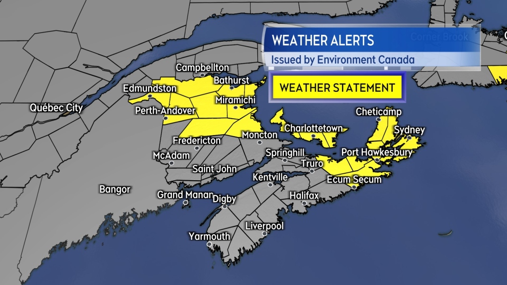 Special weather statements are in effect for northern New Brunswick, Prince Edward Island, and Cape Breton ahead of snow Thursday into Friday.
The inclement weather gets started as some initial snow arriving in western New Brunswick Thursday morning. Thursday afternoon will see the snow become more widespread in New Brunswick and a mix of snow turning to rain for western Nova Scotia.
The snow will arrive for P.E.I. and eastern Nova Scotia Thursday evening and Cape Breton late evening or near midnight. The snow will linger into Friday for P.E.I., the north shore of mainland Nova Scotia and Cape Breton. The will be a chance of flurries or showers on Friday for the remainder of the Maritimes.
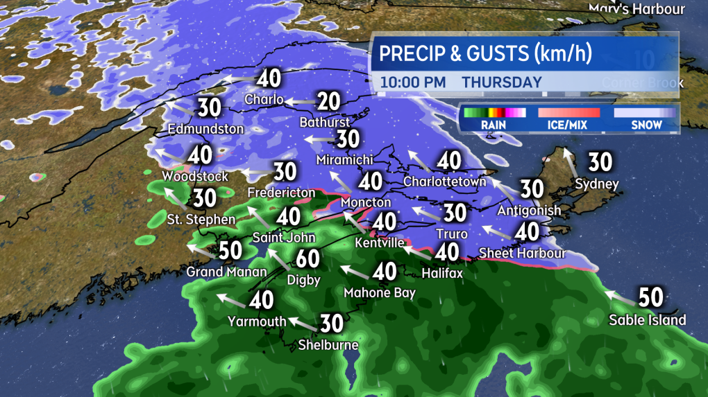 Snow will develop across a large area of the Maritimes Thursday afternoon and evening, with a turn to rain in southern New Brunswick and western Nova Scotia.”>
Given the mix of precipitation and the wet nature of the snow, accumulations will be varied around the region. As above, the highest snow potential will be northern New Brunswick, P.E.I. and eastern areas of Nova Scotia including Cape Breton.
Central areas of New Brunswick and central areas of mainland Nova Scotia could pick up five to 10 cm of snow.
Southwestern New Brunswick and western mainland Nova Scotia could see up to five cm of slushy snow before a turn to rain, which could total five to 20 mm.
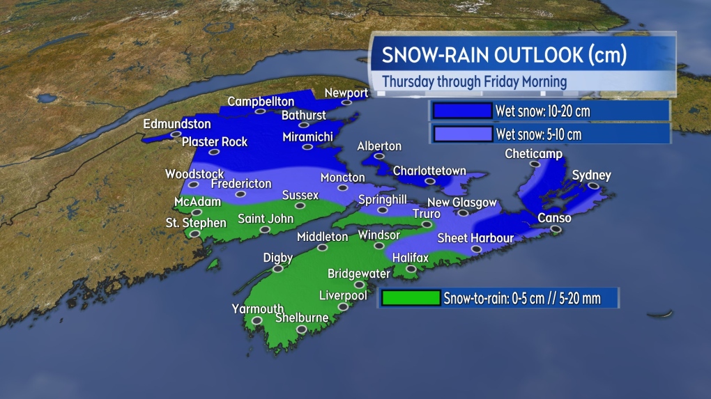 The most snow accumulation is expected in northern New Brunswick, Prince Edward Island, and eastern areas of Nova Scotia.
Wind isn’t expected to be a widespread issue with the system. Southeast gusts of 30 to 50 km/h will accompany the snow and rain, except gusts up to 60 km/h on exposed areas of the coast.
Stronger easterly gusts of 60 to 80 km/h are possible for Cape Breton Friday morning. Northern Inverness County could approach peak gusts of 100 km/h Friday morning due to the topography of the Highlands.
CTVNews.ca Top Stories

B.C. tenants evicted for landlord's use after refusing large rent increase to take over neighbouring suite
Ashley Dickey and her mother rented part of the same Coquitlam duplex in three different decades under three different landlords.
Mountain guide dies after falling into a crevasse in Banff National Park
A man who fell into a crevasse while leading a backcountry ski group deep in the Canadian Rockies has died.
opinion The special relationship between King Charles and the Princess of Wales
Royal commentator Afua Hagan writes that when King Charles recently admitted Catherine to the Order of the Companions of Honour, it not only made history, but it reinforced the strong bond between the King and his beloved daughter-in-law.
Expert warns of food consumption habits amid rising prices
A new survey by Dalhousie University's Agri-Food Analytics Lab asked Canadians about their food consumption habits amid rising prices.
MPP Sarah Jama asked to leave Ontario legislature for wearing keffiyeh
MPP Sarah Jama was asked to leave the Legislative Assembly of Ontario by House Speaker Ted Arnott on Thursday for wearing a keffiyeh, a garment which has been banned at Queen’s Park.
Charlie Woods, son of Tiger, shoots 81 in U.S. Open qualifier
Charlie Woods failed to advance in a U.S. Open local qualifying event Thursday, shooting a 9-over 81 at Legacy Golf & Tennis Club.
Ex-tabloid publisher testifies he scooped up possibly damaging tales to shield his old friend Trump
As Donald Trump was running for president in 2016, his old friend at the National Enquirer was scooping up potentially damaging stories about the candidate and paying out tens of thousands of dollars to keep them from the public eye.
Here's why provinces aren't following Saskatchewan's lead on the carbon tax home heating fight
After Prime Minister Justin Trudeau said the federal government would still send Canada Carbon Rebate cheques to Saskatchewan residents, despite Saskatchewan Premier Scott Moe's decision to stop collecting the carbon tax on natural gas or home heating, questions were raised about whether other provinces would follow suit. CTV News reached out across the country and here's what we found out.
Montreal actress calls Weinstein ruling 'discouraging' but not surprising
A Montreal actress, who has previously detailed incidents she had with disgraced Hollywood producer Harvey Weinstein, says a New York Court of Appeals decision overturning his 2020 rape conviction is 'discouraging' but not surprising.


