Weather warnings in effect as fall storm moves through the Maritimes
It will be a messy evening across the Maritimes on Monday. A large area of low pressure, and associated weather fronts, continues to bring a mix of snow and rain, along with high and gusty winds.
Accumulating snow has mostly been restricted to northern areas of New Brunswick, with Madawaska County and the western half of Restigouche County placed under a snowfall warning that calls for up to 15 cm of snow. The snow will be wet by nature, possibly mixed with rain.
Much of the rest of the Maritimes will see rain, with amounts in a general range of 10 to 40 mm. Higher rain totals are expected in parts of Nova Scotia, with rainfall warnings calling for totals of 40 to 60 mm in eastern Halifax County and Guysborough County. The rain and snow will clear west-to-east in the afternoon through evening.
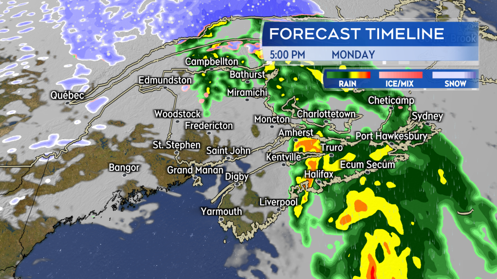 Snow clearing northern New Brunswick and rain clearing the remainder of the Maritimes Monday afternoon through evening.
The southeast wind has and continues to be strong. Gusts ranging 60 to 80 km/h have been reported in the Bay of Fundy and along exposed coastal areas of Nova Scotia and Prince Edward Island. A round of stronger southeast gusts are expected to arrive on the Eastern Shore of mainland Nova Scotia, as well as Cape Breton late Monday afternoon through evening. Those areas could peak with gusts near 90 km/h and are under a wind warning. Due to the topography of the Highlands, northern Inverness County could reach peak gusts of 130 km/h Monday evening and night.
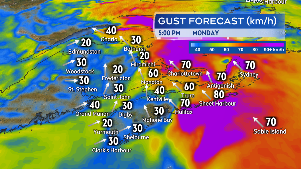 Some of the strongest southeast winds are expected in eastern areas of Nova Scotia late afternoon through evening. Gusts near 90 km/h, expect stronger coming down the Highlands in Inverness County.
The wind is expected to become westerly and diminish in western parts of the Maritimes by Monday evening. Eastern parts of the Maritimes follow by midnight. The Sydney area in Cape Breton may linger in the southeast wind until a few hours after midnight.
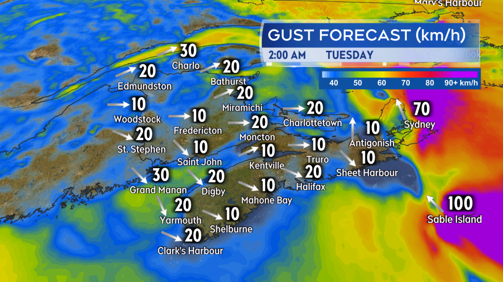 By midnight, most of the region will be over to a westerly wind with greatly diminished gusts.
Two storm surge warnings were issued in the Maritime region. One for the Acadian Peninsula and one for parts of the coastline of the Bay of Chaleur. The warnings call for waves up to three metres breaking as they near shore and higher than normal water levels near the high tide, close to 4 p.m.


CTVNews.ca Top Stories

LIVE UPDATES
LIVE UPDATES Multiple homes, businesses 'lost' to wildfire in Jasper National Park: Parks Canada
Officials from Parks Canada and Jasper say "multiple structures, including a number of businesses and homes, in and around the town of Jasper, have been lost" to wildfire in Jasper National Park.
Alberta premier says a third, perhaps half, of all Jasper buildings destroyed by fire
Alberta Premier Danielle Smith says early reports indicate a third and perhaps up to half of all buildings in the historic Rocky Mountain resort town of Jasper have burned in a wildfire.
Prince William's 2023 salary revealed in new report
Newly released financial reports show that William, the Prince of Wales, drew a salary of $42.1 million last fiscal year, his first since inheriting the vast and lucrative Duchy of Cornwall.
Tourist suffers 3rd-degree burns to feet after losing flip flops amid soaring temperatures in Death Valley
A tourist was hospitalized after suffering serious burns on his feet on Saturday when he lost his flip flops at a U.S. national park where temperatures soared past 48 Celsius.
'There's mom and dad's house': New video appears to show destruction of Jasper neighbourhood
Video posted to social media on Thursday morning appears to show the charred remains of a Jasper, Alta., neighbourhood.
Former judge with disputed Cree heritage likely has Indigenous DNA: law society
The Law Society of British Columbia says a DNA test shows a former judge and Order of Canada recipient accused of falsely claiming to be Cree "most likely" has Indigenous heritage.
Australian field hockey player opts to amputate part of his finger in order to compete in Paris Olympics
In the run up to the Paris Olympics, athletes have been stepping up their preparations in order to maintain their edge over competitors. But for Australia’s Matt Dawson, those preparations looked a little different this year, with the field hockey player opting to have part of his finger amputated in order to compete in the Games.
Canada to bring home fewest Olympic medals since 2012, according to forecaster
Fewer Canadians are expected to reach the Paris podium than in the previous two Olympic Summer Games, a global data analytics company predicts.
Jennifer Aniston criticizes JD Vance for 'childless cat ladies' remarks: 'I pray that your daughter is fortunate enough to bear children'
Jennifer Aniston is criticizing JD Vance for comments he made in his past about women without children.
Shopping Trends
The Shopping Trends team is independent of the journalists at CTV News. We may earn a commission when you use our links to shop. Read about us.


Toronto
-

Police identify man and woman killed in quadruple shooting in Toronto
Toronto police have now identified the two victims killed in a quadruple shooting in Scarborough, Ont. early Wednesday morning.
-
Man critically injured in 3-vehicle collision in Etobicoke
A man has been critically injured in a three-vehicle collision in north Etobicoke.
-
New details emerge in wrong-way crash on Hwy. 401 that killed baby and grandparents
Durham Regional Police have confirmed new details about a deadly wrong-way crash on Highway 401 which claimed the lives of a baby and his grandparents following a police chase in April.
Calgary
-

Calgary events cancelled, altered amid air quality advisory
An air quality advisory was issued for Calgary Thursday, as wildfire smoke engulfed the city.
-
Calgary reception centre to remain open for 48 hours to support wildfire evacuees
Calgary Mayor Jyoti Gondek says the city's reception centre for Jasper wildfire evacuees will remain open for the next 48 hours.
-
Stage 1 Water restrictions remain in as heat wave snaps
The heat wave hammering Calgary lifted Thursday, but the city continues to maintain Stage 1outdoor water restrictions a little while longer.
Edmonton
-
LIVE UPDATES
LIVE UPDATES Multiple homes, businesses 'lost' to wildfire in Jasper National Park: Parks Canada
Officials from Parks Canada and Jasper say "multiple structures, including a number of businesses and homes, in and around the town of Jasper, have been lost" to wildfire in Jasper National Park.
-
Alberta premier says a third, perhaps half, of all Jasper buildings destroyed by fire
Alberta Premier Danielle Smith says early reports indicate a third and perhaps up to half of all buildings in the historic Rocky Mountain resort town of Jasper have burned in a wildfire.
-
'Now lost': Jasper fire torching cherished memories along with forests
Social media was awash Thursday with memories of Jasper proposals, weddings and honeymoons. But the town is steeped in memory of all kinds.
Montreal
-

3 tornadoes confirmed as truck toppled, trees uprooted south of Montreal
A tornado overturned a truck and uprooted several trees in Brossard on Montreal's South Shore.
-
Laurentians municipality mulls banning wakesurfing
Public consultations have been launched on a draft bylaw in Saint-Adolphe-d'Howard that would prohibit wake boats from Lac Saint-Joseph and neighbouring Lac Sainte-Marie.
-
Persistent flooding angers Town of Mount Royal residents
In the Town of Mount Royal (TMR), several households have been suffering from persistent flooding following torrential downpours.
Ottawa
-

Youth receiving support from Children's Aid Society of Ottawa dies
The Children's Aid Society of Ottawa (CASO) and striking workers with the Ontario Public Service Employees Union (OPSEU) say a youth who was receiving support from the agency has died.
-
Storms cause significant damage in Cornwall, Ont.
A series of powerful storm cells swept across areas of Ontario on Wednesday, hitting parts of Cornwall, Ont. -- particularly hard.
-
Tornado near Perth, Ont. during severe weather on Wednesday, Northern Tornadoes Project says
Western University's Northern Tornadoes Project says a tornado touched down near Perth, Ont. Wednesday night, as a series of severe storms moved across eastern Ontario.
London
-

Poilievre takes on crime, drugs, word terminology, and the media in London, Ont.
Federal Conservative leader Pierre Poilievre's tour through London Thursday focussed on justice and outrage over safe supply, and the term 'safe supply' itself.
-
25-year-old Londoner faces human trafficking charges
A man is now facing a wide swath of charges following an investigation by London Police Services Human Trafficking Unit. Beginning in April 2019, a woman entered an agreement with a man, employed as a sex worker.
-
$1.3-million drug bust by London police
On July 16, police from the guns and gangs section arrested two people after using warrants on two vehicles and a home in Eclipse Walk.
Barrie
-
Ont. mayor fires back at 'misinformation' about people defecating on beach
Wasaga Beach's mayor is firing back at unverified claims circulating on social media that people are defecating in the sand at the provincial park.
-
Loose wheel hits 4 vehicles on Highway 400 in Innisfil
Four vehicles sustained damage while travelling along Highway 400 in Innisfil Thursday morning after a wheel came loose.
-
Fire officials alarmed by trend of suspected arson in under-construction homes
The Ontario Association of Fire Chiefs is sounding the alarm on a recent trend involving what's believed to be the intentional destruction of new builds.
Northern Ontario
-

Worker killed at New Gold mine in northwestern Ont.
An employee operating a piece of equipment in an open pit was killed Wednesday at New Gold's gold mine in Rainy River.
-
'I'm so broke': Two Toronto women speak out after losing $76,000 in romance scam
Two women from the Toronto area are speaking out after losing thousands of dollars to a romance scam, including a single mother who lost $62,000.
-
CUPE, Group Health Centre in the Sault agree to tentative contract
A day before a strike was to begin, Group Health Centre and CUPE Local 894 in Sault Ste. Marie reached a tentative contract Thursday.
Kitchener
-

Home invasion shooting in Cambridge leads to 3 arrests and serious injuries: WRPS
The Waterloo Regional Police Service (WRPS) have arrested three males, including one teen, in connection to a home invasion shooting on Wednesday night that left multiple people injured.
-
Steven Lorentz hoists the Stanley Cup at Kitchener, Ont. cancer centre
Patients at the Grand River Regional Cancer Centre got a special treat, when Steven Lorentz stopped by the Stanley Cup.
-
New charges related to 2023 murder of Guelph man
Four people are facing new charges in connection to a homicide investigation that started nine months ago.
Windsor
-
 EXCLUSIVE
EXCLUSIVE Newborn data allegedly accessed by doctor seeking profit
The joy and excitement of welcoming a new baby has been marred for a Belle River mom, who says she’s “disturbed” to learn a doctor looking to profit targeted her newborn.
-
Shed fire causes $300,000 damage
Chatham-Kent firefighters were called to a working structure fire on Thursday.
-
Leroux feeling uneasy after Bubba Pollock sentencing pushed to September
Bubba Pollock pleaded guilty to harassment back in January and was court Thursday for sentencing.
Winnipeg
-

Cycling community placing 'Ghost Bike' to remember man killed while riding his bike
Winnipeg's cycling community is coming together Thursday night to remember the victim of a fatal hit-and-run last month.
-
Accidental tourist ends up in Winnipeg after Jasper wildfire interrupts rail journey
A California traveller made an unscheduled stop in Winnipeg due to the ongoing wildfire in Jasper, Alta.
-
Boys, including nine-year-old, arrested following break and enter, arson: Winnipeg police
Five boys, including a nine-year-old, have been arrested following a break-and-enter and an arson in the West End early Thursday morning.
Regina
-

Regina crime rate increases slightly, ranks ninth in country: Stats Can
An annual report from the Canadian Centre for Justice Statistics (CCJS) shows Regina’s crime rate increased slightly from 2022 to 2023.
-
Amazing Race Canada teams to head to Regina in upcoming episode
The upcoming episode of the Amazing Race Canada will have the teams touching down in Regina.
-
Moose Jaw man charged with trafficking guns, lying to officers
Police in Moose Jaw have laid charges following a more than year-long investigation involving firearms trafficking in the city.
Saskatoon
-

'It was like torture': Saskatoon mother is relieved her son's accused killer is locked up
A Saskatoon mother says she feels a “little bit better” knowing that police caught her son’s accused killer.
-
Sask. police renew calls for information in 44-year-old missing person case
The Prince Albert Police Service (PAPS) is renewing calls for information in the disappearance of Robert Wiggins 44 years ago.
-
Saskatoon men arrested on child exploitation charges
The Saskatchewan Internet Child Exploitation (ICE) unit has arrested and charged two men with child exploitation offences.
Vancouver
-

Woman killed in Maple Ridge identified as IHIT appeals for information
Homicide investigators have identified a woman who was killed in Maple Ridge last weekend in what they say was an "isolated incident."
-
Driver will not be charged in crash that killed municipal worker near Victoria
An elderly woman who struck and killed a 52-year-old father who was working in a construction zone near Victoria last year will not face criminal charges in the case, authorities announced Thursday.
-
B.C. lets wineries import grapes for 2024 vintages after 'devastating' winter losses
The B.C. government says wineries can import grapes and juice to make their 2024 vintages after "devastating" losses this winter.
Vancouver Island
-

Driver will not be charged in crash that killed municipal worker near Victoria
An elderly woman who struck and killed a 52-year-old father who was working in a construction zone near Victoria last year will not face criminal charges in the case, authorities announced Thursday.
-
B.C. lets wineries import grapes for 2024 vintages after 'devastating' winter losses
The B.C. government says wineries can import grapes and juice to make their 2024 vintages after "devastating" losses this winter.
-
Former judge with disputed Cree heritage likely has Indigenous DNA: law society
The Law Society of British Columbia says a DNA test shows a former judge and Order of Canada recipient accused of falsely claiming to be Cree "most likely" has Indigenous heritage.
Kelowna
-

Kamloops RCMP officer charged with assault, mischief
A Kamloops Mountie has been charged with assault and mischief in connection to an incident that occurred last summer, Crown prosecutors announced Wednesday.
-
2 dead after serious crash on Highway 1 in B.C. Interior
Two people are dead after a serious crash that shut down Highway 1 near Sorrento, B.C. Saturday morning.
-
Structures lost to Shetland Creek wildfire as more heat, thunderstorms strike parts of B.C.
The number of wildfires in British Columbia has flared as more lightning storms bring the potential for further fire starts.


