More thaw and freeze ahead in the Maritimes this week
 A pedestrian tries to shield herself from heavy wind and rain in Halifax on Friday, December 23, 2022. THE CANADIAN PRESS/Darren Calabrese
Weekend rain summary
Following a weekend that saw heavy rain transition to a flash freeze, a similar weather situation is ahead for the Maritimes later this week.
The heaviest rain fell across Nova Scotia and Prince Edward Island. Fairly widespread amounts of 30 to 60 mm was reported in those areas. Personal weather stations in Victoria County, Cape Breton, reported some totals of 70 to 85 mm of rain. The rain, along with snow/ice melt and blocked drainage, created some instances of localized flooding.
The quick change to a northerly wind behind the rain brought temperatures back down below freezing in just a matter of hours and remaining standing water turned to ice. A turn back to snow for southeastern New Brunswick, northern Nova Scotia, and P.E.I. brought 5 to 15 cm of snow.
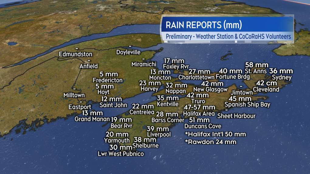 CoCoRaHS volunteers and Environment Canada-monitored weather station reports for the weekend rain.
Mid-week repeat
The weather ahead of us Wednesday into Thursday bares some similarity to this past weekend. A strong low-pressure system is expected to move up the St. Lawrence River Valley. The storm first brings a warm up and rain on Wednesday. Then on Thursday, as a cold front comes through, the rain turns to a period of snow and temperatures fall quickly back below freezing in a northwest wind.
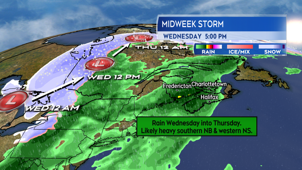 With a storm track to our west, the next system initially comes in with mild temperatures, rain, and a gusty southerly wind.
The rain could potential be very heavy for parts of the Maritimes. Guidance for the storm has possible rain totals of 40 to 70 mm for southern New Brunswick and western Nova Scotia. The same guidance indicates that pockets of rain near or over 100 mm is also possible around the Bay of Fundy coastline in New Brunswick. That amount of rain at this time of the year does come with an increased risk of localized flooding. Other areas of the Maritimes are currently indicating rain amounts of less than 40 mm.
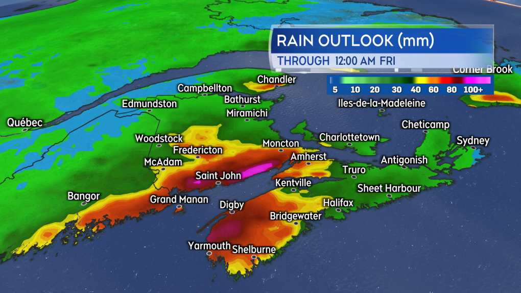 Areas of heavy rain are indicated in the south of New Brunswick and the west of Nova Scotia.
There is a higher potential for severe wind with this storm. Southern New Brunswick, Nova Scotia, and P.E.I. have indicated gusts from the south that could reach 90+ km/h late Wednesday into early Thursday morning. Gusts of 90+ km/h are the criteria for wind warnings to be issued.
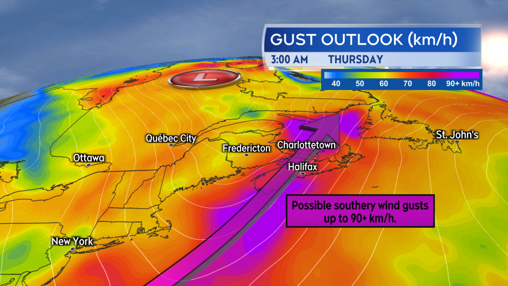 A strong southerly wind could reach gusts of 90+ km/h late Wednesday into early Thursday for parts of the Maritimes.
Weather alerts
As of Monday afternoon, there are no weather alerts for the Maritimes. In Quebec, where the storm reaches earlier, a special weather statement is in effect cautioning of a risk of localized flooding as a result of the rain and mild temperatures. The statement also mentions that behind the rain “temperatures will drop sharply, rapidly freezing water on the ground. Roads could quickly become slippery, making travel difficult.”
A hazardous weather outlook has been issued by the National Weather Service in Maine. That state is also expecting a significant rainfall followed by a possible flash freeze Wednesday into early Thursday morning.
I’ll have updates, timelines, and regional weather conditions on CTV New Atlantic at 5 p.m., 6 p.m., and 11:30 p.m.


CTVNews.ca Top Stories

DEVELOPING
DEVELOPING Jasper updates: Wildfire reaches townsite
One of two wildfires threatening Jasper National Park has reached the townsite.
Alberta calls in army to assist with wildfire situation
Alberta has called in the Canadian Armed Forces to help assist with the worsening wildfire situation in the province.
Biden explains why he ended re-election bid in Oval Office address
U.S. President Joe Biden on Wednesday delivered a solemn call to voters to defend the country's democracy as he laid out in an Oval Office address his decision to drop his bid for reelection and throw his support behind Vice President Kamala Harris.
Barrie-Innisfil MPP 'blacked-out' and crashed car into window of child care centre
Staff at a Barrie child care centre say they are frustrated by what they call a local MPP's inadequate response after a car crashed through a window in one of the toddler rooms.
Norad intercepts Russian and Chinese bombers operating together near Alaska in apparent first
The North American Aerospace Defence Command (Norad) intercepted two Russian and two Chinese bombers flying near Alaska Wednesday in what appears to be the first time the two countries have been intercepted while operating together.
2 Canadians being 'sent home immediately,' removed from Olympic team after drone incident
An analyst and an assistant coach with Canada Soccer are being removed from the Canadian Olympic Team and 'sent home immediately,' according to the Canadian Olympic Committee.
An unwelcome attendee has joined the Paris Olympic Games: COVID-19
After a handful of Australian water polo players tested positive for COVID-19 this week, questions have emerged around how the spread of the disease will be mitigated at the Summer Olympic Games in Paris.
Vacations, meals, booze: Contractor used $100K of charity's money for personal expenses, B.C. court finds
A B.C. man who was hired to help a non-profit build a food hub but instead spent the money on personal expenses – including travel, restaurants, booze and cannabis – has been ordered to pay more than $120,000 in damages.
Male, female killed, 2 others injured in 'gun battle' outside Toronto plaza: police
Two people are dead and two others suffered serious injuries following a shooting that police have described as a 'gun battle' outside a plaza in Scarborough, Ont. early Wednesday morning.
Shopping Trends
The Shopping Trends team is independent of the journalists at CTV News. We may earn a commission when you use our links to shop. Read about us.


Toronto
-

The Ontario Science Centre hosted a wedding the day after its dramatic shutdown
The day after the doors of the Ontario Science Centre closed to the public on the grounds that its roof was failing and unsafe, the centre’s management made an exception to allow a wedding and reception on its grounds.
-
One person dead after collision in Mississauga
One person is dead after a collision in Mississauga Wednesday afternoon.
-
Blue Jays sting Rays 6-3 with a four-run eighth inning
Back-to-back RBI singles with two out from Justin Turner and Daulton Varsho were enough to spark a four-run eighth inning and push the Toronto Blue Jays to a 6-3 win against the Tampa Bay Rays on Wednesday.
Calgary
-
DEVELOPING
DEVELOPING Jasper updates: Wildfire reaches townsite
One of two wildfires threatening Jasper National Park has reached the townsite.
-
New fire burning in Banff National Park south of Hector Lake
A new fire was reported to be burning in Banff National Park late Wednesday afternoon.
-
Canadian man killed in southern Israel has ties to Airdrie
A man from Alberta was gunned down in southern Israel on Monday, near the Gaza border while he was armed with a knife.
Edmonton
-
DEVELOPING
DEVELOPING Jasper updates: Wildfire reaches townsite
One of two wildfires threatening Jasper National Park has reached the townsite.
-
Multiple structures ablaze as wildfire roars into Jasper townsite
One of two raging, wind-whipped fires menacing Jasper, Alta., roared into town Wednesday night and began burning buildings.
-
Weather warnings downgraded to watches in central Alberta
A number of weather warnings were issued in central Alberta Wednesday night.
Montreal
-

Quebec athlete named one of Canada's 2024 Olympic flag bearer
Maude Charron will carry the Canadian flag during Friday's Olympic opening ceremony in Paris. The athlete from Rimouski will also be defending her Olympic gold medal in weightlifting.
-
Montreal electronic traffic signs hacked to display pro-Palestinian political slogans
Montreal police are investigating after electronic message boards at two road construction sites in Montreal displayed pro-Palestinian political slogans Wednesday morning instead of usual traffic alerts.
-
Service resumes on the metro's orange line after water main leak: STM
Montreal's transit authority said a water main break disrupted service on part of the metro's orange line during the afternoon commute Wednesday.
Ottawa
-
 SEVERE THUNDERSTORM WATCH
SEVERE THUNDERSTORM WATCH Severe storms move across eastern Ontario, prompting weather warnings
A series of weather watches were issued across Ottawa and eastern Ontario, as severe storms moved through the area Wednesday.
-
Canada soccer fans express shock, disappointment from Olympic team drone incident
The Olympics begin Friday, but it's been an embarrassing debut for the Canada’s women's soccer team who are now embroiled in a major scandal.
-
Bank of Canada rate cut sparks optimism in Ottawa
With the dark cloud of higher interest rates looming overhead, many small, local construction companies have been waiting for interest rates to drop before taking on risk and kickstarting projects in and around the capital.
London
-

17-year-old victim of intimate partner violence was previously violently attacked by her partner
17-year-old Breanna Broadfoot, who will be honoured with a vigil on Wednesday night, had allegedly previously been attacked by her partner, residing in the same home where she later received fatal injuries.
-
Driver walks home after police tow vehicle that revved at Mitchell stop light
Nobody likes a loud and aggressive driver – but one such driver caught the attention of the wrong police officer when they revved their engine at a red light in Mitchell in early July.
-
Political U-turn kills plan to reduce speed limits in dozens of school zones on London’s busiest roads
On Tuesday, a majority of council rejected a recommendation by the Civic Works Committee that would have reduced speed limits by 10 km/hr in school zones along arterial roads during periods when students are usually present.
Barrie
-

Barrie-Innisfil MPP 'blacked-out' and crashed car into window of child care centre
Staff at a Barrie child care centre say they are frustrated by what they call a local MPP's inadequate response after a car crashed through a window in one of the toddler rooms.
-
New police vehicle turns heads along Barrie's waterfront
Barrie police are using a utility vehicle along the city's waterfront this summer to help officers get to challenging locations and increase their presence throughout the busy area.
-
What does Bank of Canada's interest rate cut mean for homeowners?
The Bank of Canada lowered its key interest rate to 4.5 per cent, as those looking to renew or buy a mortgage watched closely.
Northern Ontario
-

2 Canadians being 'sent home immediately,' removed from Olympic team after drone incident
An analyst and an assistant coach with Canada Soccer are being removed from the Canadian Olympic Team and 'sent home immediately,' according to the Canadian Olympic Committee.
-
Northern Ont. reaction to Canada's Olympic controversy
With soccer growing in popularity in Sudbury, some with experience in the sport are with confusion and disappointment to the recent news out of the Olympics.
-
Barrie-Innisfil MPP 'blacked-out' and crashed car into window of child care centre
Staff at a Barrie child care centre say they are frustrated by what they call a local MPP's inadequate response after a car crashed through a window in one of the toddler rooms.
Kitchener
-

Guelph, Ont. police constable continues to fight for his job
A police constable in Guelph, Ont. pleaded guilty Wednesday to discreditable conduct – for a second time.
-
Cambridge mother blames GRCA for flood that destroyed her belongings
A Cambridge woman explains why she blames the GRCA for a flood that damaged her home and forced her family to flee in a canoe.
-
Wanted teen considered dangerous after escaping secure custody facility: WRPS
The Waterloo Regional Police Service (WRPS) is searching for a 16-year-old they say escaped a security custody facility in Wilmot Township.
Windsor
-

'We want what's best for the neighbourhood': Residents given more time to lobby for change
The residents of Spago Crescent in South Windsor are open to change.
-
Thousands expected for car festival this weekend In Amherstburg
This weekend, the town of Amherstburg will be a car-lover's dreamland come true.
-
Politicians come together to celebrate Gordie Howe International Bridge deck connection
Politicians came together at the Gordie Howe International Bridge Wednesday afternoon to celebrate its deck connection.
Winnipeg
-

Search of North End property linked to 2021 missing person case
The Winnipeg Police Service (WPS) is executing a search warrant at a North End property on Wednesday to look for evidence linked to a missing person case from 2021.
-
Elementary school in Thompson goes up in flames
An elementary school in Thompson, Man., has gone up in flames on Wednesday.
-
Church of rock: Jets owner, The Brothers Landreth save dwindling Winnipeg church, give it added purpose
A saving grace for a dwindling Winnipeg church has come in the form of Winnipeg Jets owner Mark Chipman and Juno-award-winning folk duo The Brothers Landreth.
Regina
-

Traffic restrictions in place after crash near Highway 1: Moose Jaw police
Drivers passing through Moose Jaw can expect some delays following a crash near Highway 1.
-
Water upgrades near completion at Buffalo Pound Water Treatment Plant
Residents in Regina and Moose Jaw will soon have better tasting water.
-
Regina outreach groups work to help vulnerable people in the heat
With Regina facing another round of hot temperatures, in addition to smoke lingering in the air, it is a particularly difficult time for those experiencing homelessness.
Saskatoon
-

'A bright light': Trevor LaPlante identified as Prince Albert homicide victim
Prince Albert is grieving the loss of one of its most beloved neighbours and community champions.
-
'It's a big deal': Harmful invasive species a growing concern in Saskatchewan lakes
As people get out and enjoy the many lakes in our province this summer, those who take care of the waterways are warning about dangerous invasive species that’s a growing threat in Saskatchewan.
-
‘Restored our faith in humanity': Community rallies around 7-year-old Sask. girl after lemonade stand robbery
A seven-year-old Saskatoon girl is dealing with the aftermath from her lemonade stand being robbed by two teenage boys on Monday.
Vancouver
-

'How can we be going backwards?' Vancouver city council votes to allow natural gas heat in new buildings
Vancouver city council has voted to allow natural gas for heating and hot water in new construction.
-
'We've pretty much lost our range': Ranch manager loses second range in 3 years to wildfires
T.J. Walkem, along with more than 80 of his cows, has spent the last few days desperately trying to evade the out-of-control Shetland Creek wildfire.
-
80,000 lightning flashes in B.C. in 3 days
Environment Canada has recorded a whopping 80,007 lightning flashes in British Columbia from Sunday through Tuesday, and the count continues on Wednesday for what could be a record-breaking stretch.
Vancouver Island
-

'No known connections' between recent sexual assaults on Vancouver Island, police say
Police on Vancouver Island are investigating three sexual assaults by strangers that were reported in the past week, though there is no indication the attacks are connected.
-
Vacations, meals, booze: Contractor used $100K of charity's money for personal expenses, B.C. court finds
A B.C. man who was hired to help a non-profit build a food hub but instead spent the money on personal expenses – including travel, restaurants, booze and cannabis – has been ordered to pay more than $120,000 in damages.
-
Vancouver Island wildfire grows overnight, remains out of control
A wildfire burning out of control on Vancouver Island continued to spread Wednesday as the provincial wildfire service assigned more resources to try to contain the blaze.
Kelowna
-

Kamloops RCMP officer charged with assault, mischief
A Kamloops Mountie has been charged with assault and mischief in connection to an incident that occurred last summer, Crown prosecutors announced Wednesday.
-
2 dead after serious crash on Highway 1 in B.C. Interior
Two people are dead after a serious crash that shut down Highway 1 near Sorrento, B.C. Saturday morning.
-
Structures lost to Shetland Creek wildfire as more heat, thunderstorms strike parts of B.C.
The number of wildfires in British Columbia has flared as more lightning storms bring the potential for further fire starts.


