Remnants of Ida will bring heavy rain to most of the Maritimes

HALIFAX -
While declared post-tropical, and with no further forecast updates from the National Hurricane Center forthcoming, the remnants of the former hurricane Ida are expected to affect weather in the Maritimes later this week.
The system is forecast to exit the U.S. eastern seaboard near Delaware and then moves northward taking it on a path across Nova Scotia late Thursday through Friday.
While no longer tropical in nature the remnants of Ida have developed into a large, heavy rain producing system.
It will be quite a large weather system by that time, having developed both a warm and cold front. Most of the Maritime region can expect rain with some areas seeing heavy rain and downpours.
Rain is forecast to start as early as Thursday morning in the southwest of Nova Scotia. Rain will be more widespread for the region by Thursday evening. The rain will begin clearing, west-to-east, Friday morning into early afternoon.
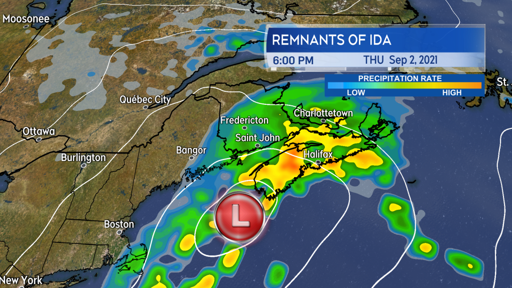
Rain becomes more widespread by Thursday evening as the track of the remnants of Ida take it towards and across Nova Scotia.
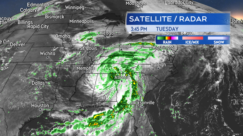
As of Tuesday afternoon, the potential for heavier rain looked most likely for Nova Scotia, southeastern New Brunswick, and central/eastern Prince Edward Island. Those areas may see a fairly widespread 50 to 80 mm with pockets of 80 to 100 mm possible. With that much rain in a span of about 24 hours, there is a risk of some flooding and flash flooding. There remains a possibility of a shift west or east with the heavier rain. Communities in western P.E.I. and eastern New Brunswick should check frequently in on their forecast as a shift west could place them in the heavier rain as well.
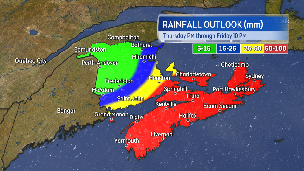
Nova Scotia, PEI, and parts of southeastern New Brunswick with the best odds of seeing higher rainfall totals from the passing system Thursday into Friday.
It would be a good idea to check drainage around your residence to ensure that it is clear of summer debris. If you sometimes need to use a sump pump in the event of a heavier rain, you could check to make sure it is in working order as well.
For driving considerations, the risk of downpours looks to be highest and most widespread Thursday evening, Thursday night, and very early Friday morning.
Gusty winds are expected with the rain. First east and northeast on Thursday with gusts ranging 20 to 50 km/h. Then turning north and northwest on Friday with gusts ranging 40 to 70 km/h. The strongest gusts are most likely at higher terrain and on exposed areas of the coast.
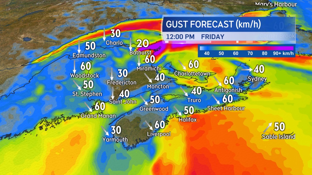
Winds with the remnants of Ida look highest on Friday as they turn north and northwest. Increasing to include gusts ranging 40 to 70 km/h.
Environment Canada issued special weather statements on Tuesday afternoon with cautions about the heavy rain and gusty winds for Nova Scotia, P.E.I., and parts of southern New Brunswick.


CTVNews.ca Top Stories

Job losses and killer robots: The 'Godfather of AI' describes plenty to fear, but there may be room for hope
University of Toronto computer scientist Geoffrey Hinton describes plenty to fear with AI, but with visions of combat drones, mass surveillance and robot overlords ahead, there may be space for hope.
'I'm sorry, I'm just frustrated': Video appears to show man spit on MP
A video circulating online appears to show MP and former cabinet minister Marco Mendicino get spat on while on his way into a government building in Ottawa.
4 people found dead in southwestern Ontario town of Harrow
Ontario Provincial Police are investigating after four people were found dead in the town of Harrow, just south of Windsor. Officers were called to a residence on County Road 13 at approximately 1:30 p.m. on Thursday.
More than 100 stolen vehicles recovered in auto theft probe involving ServiceOntario employee: Toronto police
Toronto police say they have arrested four suspects and recovered more than 100 stolen vehicles as part of a months-long auto theft probe that involved a former ServiceOntario employee.
EXCLUSIVE
EXCLUSIVE 'We were in danger': Timmins, Ont., manhunt prompts questions from cottagers near shootout
Cottagers who live near the area where murder suspect Lucas MacDonald was captured say they didn't realize how much danger they were in.
Car dealerships in Canada, U.S. disrupted by multi-day outage after cyberattacks
CDK Global, a company that provides software for thousands of auto dealers in the U.S. and Canada, was hit by back-to-back cyberattacks on Wednesday. That led to an outage that continued to impact many of their operations on Friday.
Shiny monolith removed from mountains outside Las Vegas. How it got there is still a mystery
A strange monolith found jutting out of the rocks in a remote mountain range near Las Vegas has been taken down by authorities.
It's the longest bridge ever built in Peru, and so far, it goes nowhere
It is the longest bridge ever built in Peru, a massive structure of cement and iron spanning the Nanay River as it connects to untouched areas of the Peruvian Amazon. So far, it goes nowhere.
Skin cancer signs: How can you tell if a suspicious spot is serious?
Doctors say changes in the skin are normal as you age, from spots of various colours to dark streaks in nails. But sometimes, they're not innocuous.
Shopping Trends
The Shopping Trends team is independent of the journalists at CTV News. We may earn a commission when you use our links to shop. Read about us.


Toronto
-
 BREAKING
BREAKING Ontario Science Centre abruptly closing due to structural issues
The Ford government says it will be permanently closing the Ontario Science Centre to the public “effective immediately” due to “serious structural issues” that were identified with the building in a recent engineering report.
-
One person dead, three injured in 'targeted' shooting at Vaughan, Ont. home: police
One person has died and three others are in hospital following a shooting at a home in the Woodbridge area in Vaughan.
-
This 16-year-old is U of T's youngest graduate since at least 1979
Honciuc Menendez is barely old enough to get a driver’s licence but on Friday he’ll officially graduate from the University of Toronto with distinction.
Calgary
-

'It can happen anywhere': Calgary mayor commits to critical look at water infrastructure
Calgary Mayor Jyoti Gondek says she wants other municipalities to come together to learn all they can from the city's water crisis, which she said could happen anywhere in Canada.
-
Northbound lanes of QE II closed due to Friday vehicle fire
Didsbury RCMP and emergency services were on scene shortly after noon Friday responding to vehicle fire on the QE II at the intersection of Township Road 294.
-
Hikers injured in Waterton bear attack out of hospital, bear not yet located
Parks officials say two hikers injured in an Alberta bear attack last week are now out of hospital.
Edmonton
-

Alberta NDP to name new leader to replace Rachel Notley Saturday
In less than 24 hours, the Alberta NDP is expected to name its new leader in Calgary.
-
Motorcyclist dead in crash on James Mowatt Trail
A 27-year-old man is dead after crashing his motorcycle in southwest Edmonton Thursday evening.
-
Pedestrian killed in crash on Sherwood Park's Wye Road
A Sherwood Park man is dead after being hit by a vehicle on Sherwood Park's Wye Road Thursday evening.
Montreal
-

Quebec judge denies bid by billionaire Robert Miller for stay in sex crimes trial
A Quebec Superior Court judge has declined to hear a Quebec billionaire businessman's application for a stay of proceedings after his lawyers argued he was too sick to appear in court next month.
-
Satellite imagery confirms 5 tornadoes hit Quebec during June 13 storm
The Northern Tornadoes Project (NTP) out of Western University in Ontario confirmed that five tornadoes touched down in Quebec during the June 13 storm, bringing the total number of tornadoes in the project to six.
-
Canadian player racially abused online in wake of 2-0 Copa America loss to Argentina
Canada's impressive performance in a 2-0 loss to top-ranked Argentina at Copa America has come at a cost.
Ottawa
-

'I'm sorry, I'm just frustrated': Video appears to show man spit on MP
A video circulating online appears to show MP and former cabinet minister Marco Mendicino get spat on while on his way into a government building in Ottawa.
-
Two people facing charges in hate-motivated vandalism incident in Barrhaven, Ottawa police say
Two people are facing charges in connection to alleged hate-motivated vandalism at a Barrhaven home, according to Ottawa police. Police launched an investigation on June 7 after receiving an online report about an incident at a home on Maynooth Court.
-
Ottawa D-Day veteran Roly Armitage dies at age 99
An Ottawa D-Day veteran has died just weeks after the 80th anniversary of Canadian soldiers landing on Juno Beach in Normandy, France.
London
-

Bat in the region tests positive for rabies
Southwestern Public Health is warning that a bat in the region has tested positive for rabies. Found in Dutton-Dunwich, the bat was sent for testing after two people were potentially exposed to the saliva of the bat.
-
Tears flow for victims’ families at sentencing hearing of Petronella McNorgan
Tearful victim impact statements were heard at the sentencing hearing for Petronella McNorgan, the elderly woman found guilty in the horrific crash that killed a young girl and injured several others.
-
London area school bus operator transitions to electric
Schoolchildren from across the region will soon be getting onboard the green bandwagon.
Barrie
-

Disturbing details revealed at convicted killer's sentencing for Meaford man's death
Matthew McQuarrie pleaded guilty and was handed a life sentence for the murder of Emerson Sprung after the 25-year-old man's remains were found at a Meaford cemetery in May 2020.
-
Razor blades found in sandbox at Orillia playground
Police are investigating after several razor blades were found at a playground in Orillia.
-
Police cruiser involved in collision in Barrie intersection
A police cruiser with lights flashing and sirens blasting was involved in a collision on its way to a call in Barrie Thursday evening.
Northern Ontario
-
 EXCLUSIVE
EXCLUSIVE 'We were in danger': Timmins, Ont., manhunt prompts questions from cottagers near shootout
Cottagers who live near the area where murder suspect Lucas MacDonald was captured say they didn't realize how much danger they were in.
-
Former Ont. fire captain pleads guilty in wife's murder case
A former fire captain and father of two accused of killing his wife pleaded guilty on Thursday to second-degree murder.
-
Illegal moose hunters fined $56.5K, suspended for 27 years in northern Ont.
A remote hunting outpost, its former owner and 10 others have been fined a total of $56,500 after pleading guilty to various charges related to illegal moose hunting in northern Ontario.
Kitchener
-

University of Waterloo issues trespass notice to Occupy UW encampment
The University of Waterloo has issued a trespass notice to Occupy UW, saying they need to move off campus immediately.
-
More than 100 stolen vehicles recovered in auto theft probe involving ServiceOntario employee: Toronto police
Toronto police say they have arrested four suspects and recovered more than 100 stolen vehicles as part of a months-long auto theft probe that involved a former ServiceOntario employee.
-
Third suspect charged in kidnapping and murder of Kitchener, Ont. man
A third person has been charged with first-degree murder in the 2019 death of a Kitchener, Ont. man.
Windsor
-

4 people found dead in southwestern Ontario town of Harrow
Ontario Provincial Police are investigating after four people were found dead in the town of Harrow, just south of Windsor. Officers were called to a residence on County Road 13 at approximately 1:30 p.m. on Thursday.
-
Suspect arrested after several residential break-ins in west Windsor
Windsor police officers have arrested a 53-year-old man in connection to a series of residential break-and-enters in west Windsor.
-
Map of Ford Fireworks road closures and restricted access
Windsor police are letting the public know about road closures for the fireworks show over the Detroit River on Monday.
Winnipeg
-

'More than a symbolic gesture': Official renaming ceremony held for Abinojii Mikanah
For decades, a trio of roadways in Winnipeg bore the name of a bishop who led the campaign for residential schools.
-
Official results show NDP beat Tories by more than 600 votes in Manitoba byelection
Official numbers have been released for the Manitoba byelection that saw the NDP take over a historically Progressive Conservative seat.
-
Manitoba RCMP investigating homicide of 16-year-old girl
The Manitoba RCMP is investigating after a teenage girl was found dead in Easterville in the early morning hours on Friday.
Regina
-

Here's what's happening in Regina for National Indigenous Peoples Day
Friday marks National Indigenous Peoples Day and there are plenty of events happening in Regina to celebrate the history and culture of Indigenous People.
-
Severe thunderstorm watch issued for Regina, parts of southern Sask.
A severe thunderstorm watch has been issued for Regina and parts of southern Saskatchewan.
-
Here's what to do in Regina for the first weekend of summer
Summer has officially arrived in the Queen City. While there will still be some rain, the weekend will close out with some much needed sunshine.
Saskatoon
-

Melfort doctor accused of spanking child and striking another in the face
A Melfort doctor is facing a series of charges from the Saskatchewan College of Physicians and Surgeons, which alleges he hit children on two separate occasions.
-
Sask. driver dead following SUV and semi crash on Highway 4
A 52-year old Swift Current man has died after a highway collision near the community of Elrose, Sask.
-
Man dead after armed confrontation with Saskatoon police
Saskatoon police are currently at the scene of an incident on Avenue S South, between 20th Street West and 21st Street West.
Vancouver
-

Video shows dramatic Vancouver police arrest in West End neighbourhood
Police in Vancouver say a man is facing criminal charges after a dramatic arrest was caught on video near the city's downtown core.
-
Massive fire in Richmond, B.C., sends smoke across Metro Vancouver
Towering black smoke filled the evening sky in Richmond, B.C., on Thursday after an industrial fire was sparked near the River Rock Casino.
-
'High volume' of excessive speeders in Kelowna prompts highway patrol crackdown
Police in the Okanagan have been impounding more than a vehicle per day for excessive speeding this year.
Vancouver Island
-

Drivers remain in hospital, witness sought following crash in Nanaimo, B.C.
Two people remain in hospital Friday after a serious crash in Nanaimo, B.C., was caused when a wrong-way driver collided with a transport truck earlier this week, according to police.
-
Video shows dramatic Vancouver police arrest in West End neighbourhood
Police in Vancouver say a man is facing criminal charges after a dramatic arrest was caught on video near the city's downtown core.
-
B.C. researchers working to restore declining kelp forests
Kelp forests off the coast of British Columbia are in a state of decline, predominantly due to climbing ocean temperatures.
Kelowna
-

'High volume' of excessive speeders in Kelowna prompts highway patrol crackdown
Police in the Okanagan have been impounding more than a vehicle per day for excessive speeding this year.
-
Recognize this man? Kamloops RCMP seek arson suspect
Mounties in Kamloops are asking for help identifying a man they say is suspected of setting a trailer on fire earlier this month.
-
Kelowna RCMP release sketch of suspect who attempted to sexually assault stranger
Police in Kelowna have released a suspect sketch in hopes of locating the man who attempted to sexually assault a stranger on a walking trail earlier this month.


