Weather warnings blanket Maritimes as major winter storm approaches
Environment Canada issued weather warnings across the Maritimes Thursday afternoon.
 Heavy rain and high wind move into the Maritimes Friday afternoon and evening. Some accumulating snow in northern New Brunswick.
A major winter storm, moving through Ontario into Quebec, will develop a strong east-southeast wind in the region Friday afternoon into night.
Peak gusts of up to 90 km/h are called for with a few exceptions. The northeast coastline of New Brunswick could hit gusts of 110 km/h. In northern Inverness County, gusts could reach 120 km/h due to the topography of the Highlands.
The weather agency notes that “similar storms in the past have resulted in utility outages” and “high winds may toss loose objects or cause tree branches to break.”
The wind is expected to diminish west-to-east Saturday morning.
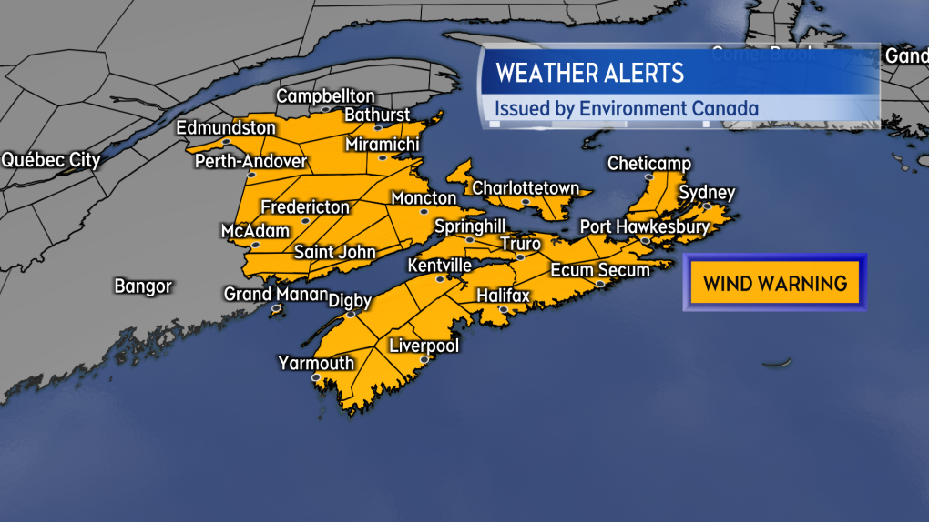 Wind Warnings are in effect for the entirety of the Maritimes.
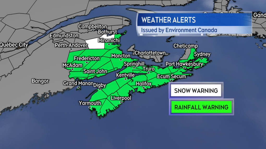
Heavy rain will accompany the strong winds. Rainfall Warnings are in effect for the entirety of the Maritimes, except the northwestern corner of New Brunswick. Rain amounts will be in the area of 20 to 40 mm, with higher local amounts possible. Water runoff from saturated or frozen ground could create localized flooding.
There is an additional risk of several hours of freezing rain for the St. John River Valley in New Brunswick Friday afternoon.
Snowfall Warnings for the storm are restricted to the Mount Carleton – Renous Highway and the Bathurst and Chaleur regions of northern New Brunswick. The warnings call for snow totals of 15 to 20 cm Friday afternoon and night, before an eventual change to rain. Other areas of northern New Brunswick could see some initial snow accumulation of less than 15 cm before a turn to rain.
 Rainfall and Snowfall Warnings issued for the region Thursday afternoon.
A risk of storm surge is noted in remaining Special Weather Statements for Nova Scotia, Prince Edward Island, and northeastern New Brunswick. While the timing for that risk spans late Friday into Saturday, it is noted that “the highest threat will be during the high tides during the day on Saturday.”
The storm will impact travel and travel services in the region. It is recommended to check on the status of flights and ferries frequently. Hazardous weather will be impacting a large portion of eastern Canada, including much of Quebec and Ontario.
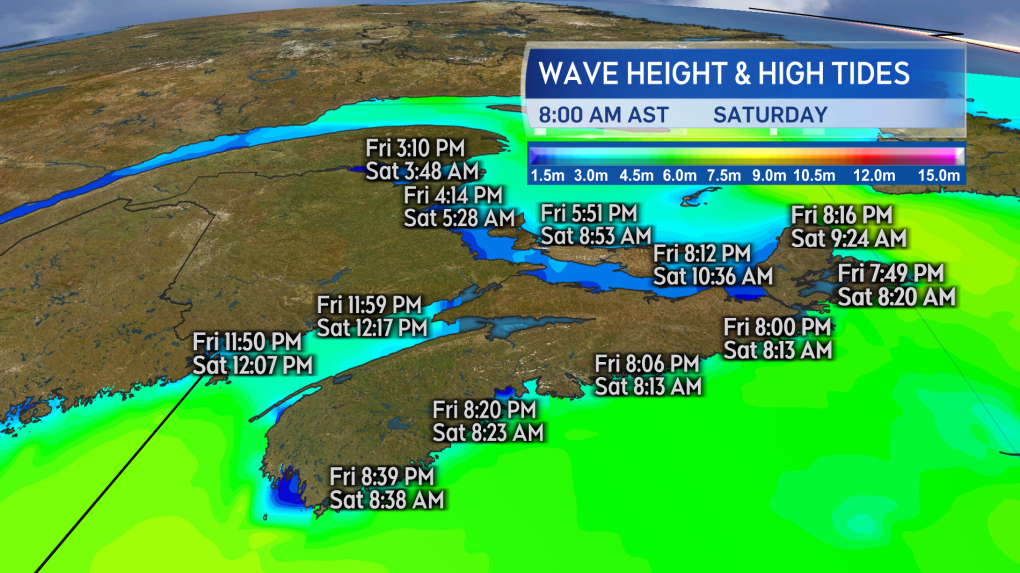 A risk of storm surge on parts of the coast during high tides late Friday into Saturday.
Nova Scotia Power and the province's emergency management officials have been monitoring the storm, which is the same system that has impacted western parts of Canada and parts of the U.S.
"Most likely there will be some power outages and restorations underway and likely damages to some roads," said Jason Mew, director of incident management with Nova Scotia's EMO. "Public works and various other provincial departments and Nova Scotia Power are all ramping up to be ready to respond."
It's anticipated trees and branches could fall and break from the powerful winds and cause widespread outages, there's also a concern for the health of some trees following Hurricane Fiona's impact in September.
"We have seen quite a bit of weakening of trees and branches since Fiona," said Sean Borden, storm lead with Nova Scotia Power. "Since then, we have had over 100 people out in the field every day removing trees around power lines."
Borden says they have crews spreading out across the province, as this storm is expected to impact the entire province, but it's tough to predict the damage.
"We'll be in a better condition closer to the event and early Saturday morning to be able to provide customers with any restoration times," said Borden.


CTVNews.ca Top Stories

NEW
NEW 'She was waiting for you': The story of how a B.C. man found his birth mother in England
After his adopted parents died, Dave Rogers set out to learn more about his birth mother. DNA results and a little help from friendly strangers would put him on a path to a small town in England.
Macklem tries to stay out of the fray as MPs do their best to use him to score points
Bank of Canada governor Tiff Macklem navigates a political minefield every time he testifies before the House of Commons finance committee.
Montreal man on the hook for thousands of dollars after a feature on his Tesla caused an accident
A Montreal man is warning Tesla drivers about using the Smart Summon feature after his vehicle hit another in a parking lot.
Israeli army tells Palestinians to evacuate parts of Gaza's Rafah ahead of an expected assault
The Israeli army on Monday ordered tens of thousands of Palestinians in Gaza's southern city of Rafah to start evacuating from the area, signalling that a long-promised ground invasion there could be imminent.
Actor Bernard Hill, of 'Titanic' and 'Lord of the Rings,' has died at 79
Actor Bernard Hill, who delivered a rousing cry before leading his people into battle in 'The Lord of the Rings: The Return of the King' and went down with the ship as the captain in 'Titanic,' has died.
Dash cam catches moment suspected drunk driver hits parked car, sends it careening into North Shore flower shop
Police say it’s fortunate no one was injured or killed in a collision at North Vancouver’s Park and Tilford shopping centre Saturday evening that sent one vehicle careening into a flower shop and another into a set of concrete barriers outside a Winners store.
A Holocaust survivor will mark that history differently after the horrors of Oct. 7
This year's Holocaust Remembrance Day, which begins on Sunday evening in Israel, carries a heavier weight than usual for many Jews around the world.
India's foreign minister reacts to murder charges, claims Canada welcomes criminals
India's Foreign Affairs Minister accused Canada of welcoming criminals from his country in response to the RCMP's recent arrests in a homicide that has roiled tensions between the two countries.
15-year-old boy stabbed in Ottawa on Thursday dies
A 15-year old boy who was critically injured after a stabbing in Nepean on Thursday has died of his injuries, Ottawa's English public school board said Sunday.
Shopping Trends
The Shopping Trends team is independent of the journalists at CTV News. We may earn a commission when you use our links to shop. Read about us.


Toronto
-

Ontario family releases statement on infant son, grandparents killed in wrong-way Highway 401 crash
An Ontario family says they are 'reeling' in 'profound grief' after losing their three-month-old son and parents visiting from India in a wrong-way crash on Highway 401 in Whitby last Monday.
-
Hundreds strike at Nestle chocolate plant in Toronto, Unifor says
Hundreds of Nestle workers walked off the job in Toronto on Sunday after rejecting a tentative agreement the union reached with the chocolate maker.
-
'We've been through a lot together': Nylander defends Leafs after playoff exit
The Maple Leafs battled back from a 3-1 series deficit against the Boston Bruins with consecutive 2-1 victories - including one that required extra time - in their first-round playoff series to push the club's Original Six rival to the limit before suffering a devastating Game 7 overtime loss.
Calgary
-

'Come together': Families, survivors remember the missing and murdered on Red Dress Day in Alberta
Events were held across Alberta on Sunday marking Red Dress Day to honour the memory of missing and murdered Indigenous women and girls.
-
Crews battle 'large' natural gas-fed fire at Marlborough home
Fire crews responded to Marlborough late on Saturday night to battle a blaze that had engulfed a home.
-
Serious collision impacts traffic along Highway 2A near Aldersyde
Emergency crews are on scene of a serious collision on Highway 7 at 32 Street East in Okotoks.
Edmonton
-

Oilers to play Game 1 vs. Canucks on Wednesday
The Edmonton Oilers will play Game 1 of their second-round series against the Canucks in Vancouver on Wednesday.
-
2 suspects arrested following south Edmonton shooting: police
Two suspects were arrested following a shooting in south Edmonton on Saturday night.
-
'Come together': Families, survivors remember the missing and murdered on Red Dress Day in Alberta
Events were held across Alberta on Sunday marking Red Dress Day to honour the memory of missing and murdered Indigenous women and girls.
Montreal
-

Montreal man on the hook for thousands of dollars after a feature on his Tesla caused an accident
A Montreal man is warning Tesla drivers about using the Smart Summon feature after his vehicle hit another in a parking lot.
-
'A tiny city:' Pro-Palestinian campus protesters organize for another week
Pro-Palestinian activists have set up tents at universities in Toronto, Ottawa, Vancouver and Montreal, following a wave of similar protests at campuses in the United States linked to the Israel-Hamas war.
-
2 people in hospital after Lachine shooting
Two men, aged 28 and 33, are in hospital after a shooting in Montreal's Lachine borough.
Ottawa
-

Woman in critical condition, 2 pets dead after apartment fire near Lebreton Flats
A woman was taken to hospital in critical condition following a fire that broke out in an apartment unit near Lebreton Flats on Sunday evening.
-
15-year-old boy stabbed in Ottawa on Thursday dies
A 15-year old boy who was critically injured after a stabbing in Nepean on Thursday has died of his injuries, Ottawa's English public school board said Sunday.
-
A warm and mostly sunny start to the work week in Ottawa
It will be a warm and sunny start to the work week in Ottawa, but colder-than-normal temperatures are in the forecast for later this week.
London
-
 PLAYOFF TRACKER
PLAYOFF TRACKER Knights are Western Conference champs
The London Knights are Western Conference champions for the second straight year!
-
Successful search and rescue by LFD in vacant building fire
The London Fire Department (LFD) received a call about a reported structure fire at the former McCormick’s building at 1156 Dundas St.
-
REDress Day being recognized in Victoria Park
May 5 is REDress Day, held annually to raise awareness of missing and murdered Indigenous women, girls and two spirit+ people in Canada.
Barrie
-

Military personnel gather in Barrie to honour lives lost in Battle of the Atlantic
Local military troops held an annual parade and ceremony to commemorate the 79th anniversary of the Battle of the Atlantic.
-
Hundreds of families take part in Matthews House hike for hospice
The 15th annual Matthews House hike for hospice was held on Sunday.
-
One person injured in rollover crash in Barrie
One person is in hospital after a single-vehicle rollover in Barrie on Saturday.
Northern Ontario
-

Battalion trample Generals in Game 6, forcing deciding Game 7
The North Bay Battalion have beaten the Oshawa Generals 8-1 at home to push their OHL Eastern Conference Championship series to a Game 7.
-
El Nino weakening doesn't mean cooler temperatures this summer, forecasters say
As Canadians brace themselves for summer temperatures, forecasters say a weakening El Nino cycle doesn’t mean relief from the heat.
-
Crash closes Hwy 101 in Timmins
Highway 101 East in Timmins is closed in both directions due to a single-vehicle crash.
Kitchener
-

Event in Kitchener honours Missing and Murdered Indigenous people on Red Dress Day
A solemn event was held in Kitchener to honour Missing and Murdered Indigenous Women, Girls, and Two-Spirit people.
-
'It was completely underwater': Cambridge community remembers devastating flood 50 years later
May 17, 1974 started off like any other sunny spring day, but it very quickly turned into a day of disaster.
-
Hanover man arrested after police say he broke into a home, armed with an axe
A Hanover man is facing charges after police say he broke into the home a female acquaintance while armed with an axe.
Windsor
-

Windsor police seek witness to fatal motorcycle crash
The police service has made note that the person they're looking to speak to is not suspected of wrongoing, but is a key witness who may be able to provide vital information on the incident.
-
Remembering those lost in WWII Battle of the Atlantic
Canadian sailors who bravely fought in north Atlantic waters during the Second World War have been honoured in a commemorative ceremony by HMCS Hunter and Maritime Forces Pacific.
-
Man arrested after failing to stop for CKPS, charged with uttering threats to kill
While on patrol Saturday, a Chatham-Kent police officer said their onboard licence plate reader detected a vehicle with an unauthorized licence plate.
Winnipeg
-

Manitoba government launches $15M endowment fund for MMIWG2S families
Families of Missing and Murdered Indigenous Women, Girls and Two-Spirit peoples can expect more financial support from the Manitoba government as part of a new endowment fund announced Sunday.
-
22-year-old Winkler man charged with manufacturing, possessing illegal weapons: police
A 22-year-old man from Winkler, Man., is facing several charges in connection with a large seizure of weapons, including a homemade cannon.
-
Community bake sale sees sweet support for Manitoba teen battling brain cancer
A Manitoba teen’s dream of dining in Parisian cafes is about to come true with some help from The Dream Factory.
Regina
-

Regina hosts first 'Flora's Walk' in support of perinatal mental health
Sunday marked the first time Regina has taken part in an event that originated out of Ontario following the death of a new mother.
-
RCMP Heritage Centre hosts Red Dress Day event
May 5th marks Red Dress Day, a nationally recognized date that honours the lives of the many missing and murdered Indigenous women, girls and two-spirit people. In Regina, an event was held at the RCMP Heritage Centre to highlight the date and educate the public.
-
Sask. RCMP warns of increased police presence in Swift Current
Saskatchewan RCMP are asking the public to avoid areas of Swift Current due to an ongoing investigation.
Saskatoon
-

Saskatoon Airport hopes for quick resolution as WestJet mechanics' lockout looms
A spokesperson for the Saskatoon Airport said they expect no immediate impact to operations in light of an impending lockout of WestJet mechanics.
-
London Drugs stores in Saskatoon could be open again soon following 'cybersecurity incident'
Saskatoon’s three London Drugs locations are set to re-open soon, one week after a data breach shut down stores across western Canada.
-
'Love has no boundaries': Sask. couple in their 90s and 80s get married
Eighty-two-year-old Susan Neufeldt and 90-year-old Ulrich Richter are no spring chickens, but their love blossomed over the weekend with their wedding at Pine View Manor just outside of Rosthern.
Vancouver
-

'A very heavy day': Dozens attend Red Dress Day ceremony in Pitt Meadows
Red dresses dotted šxʷhék̓ʷnəs, or Spirit Square, in Pitt Meadows Sunday to honour the thousands of missing and murdered Indigenous women, girls and two-spirit people in Canada.
-
Dash cam catches moment suspected drunk driver hits parked car, sends it careening into North Shore flower shop
Police say it’s fortunate no one was injured or killed in a collision at North Vancouver’s Park and Tilford shopping centre Saturday evening that sent one vehicle careening into a flower shop and another into a set of concrete barriers outside a Winners store.
-
British Columbian homeowners born in the 1990s most likely in Canada to co-own with their parents: StatsCan
British Columbians born in the 1990s are more likely to co-own a home with their parents than anywhere else in the country, a new report from Statistics Canada has revealed.
Vancouver Island
-

Princess Anne lays wreath at Battle of Atlantic ceremony; honours late Queen
Princess Anne saluted Canadian veterans and current forces members and honoured her late mother during separate ceremonies Sunday in Victoria as she wrapped up a three-day British Columbia West Coast royal visit.
-
London Drugs begins 'gradual reopening' on 7th day after cyberattack
Almost a week after all London Drugs stores across Western Canada abruptly closed amid a cyberattack, they began a "gradual reopening" on Saturday.
-
British Columbian homeowners born in the 1990s most likely in Canada to co-own with their parents: StatsCan
British Columbians born in the 1990s are more likely to co-own a home with their parents than anywhere else in the country, a new report from Statistics Canada has revealed.
Kelowna
-

Red dresses to make fashion statement about missing and murdered Indigenous women
Models in uniquely designed red dresses are taking to the runway in British Columbia this weekend to make a powerful fashion statement about missing and murdered Indigenous women, girls and two-spirit people.
-
B.C. breweries take home awards at World Beer Cup
Out of more than 9,000 entries from over 2,000 breweries in 50 countries, a handful of B.C. brews landed on the podium at the World Beer Cup this week.
-
B.C. man rescues starving dachshund trapped in carrier: BC SPCA
An emaciated dachshund is now recovering thanks to a Good Samaritan who found the pup near a biking trail in Kelowna, according to the BC SPCA.


