HALIFAX -- Environment Canada has released a statement of new area high temperature records set on Monday throughout the Maritimes.
The temperature records were derived from a selection of historical stations in the each geographic area. They do note that it is an initial summary and does not constitute a complete or final report.
CTV Atlantic Meteorologist Kalin Mitchell selected a few of the records given.
The original lists of records can be found on the Government of Canada website.
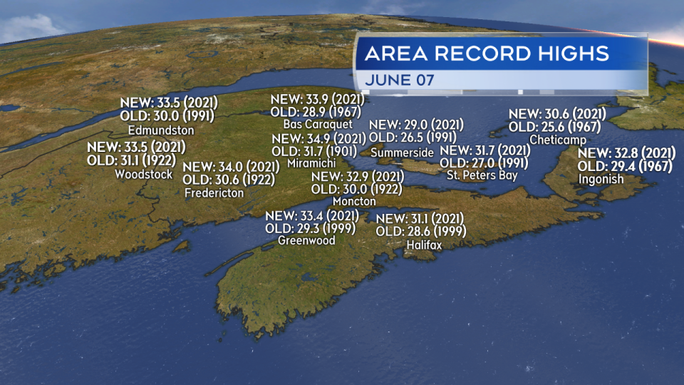
Select area high temperature records set on June 7th, 2021 per Environment Canada.
The Maritimes are in the midst of a stretch of very hot and humid weather.
A combination of high pressure to our east and a low sitting well to the northwest is forcing in hot, continental air that originates out of the US southwest.
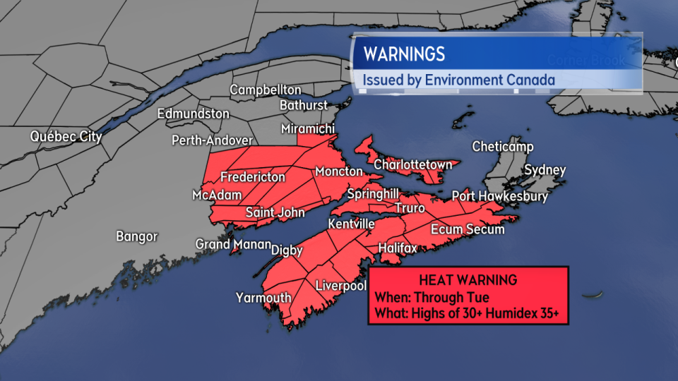 Heat Warnings issued by Environment Canada for New Brunswick, Nova Scotia, and Prince Edward Island.
Heat warnings have been issued for much of central/southern New Brunswick, mainland Nova Scotia, and Prince Edward Island. The current warnings are expected to extend into Tuesday. Heat warning criteria differs slightly from province to province but generally requires two days of hot days and warm nights. Humidex (what it feels like when temperature and humidity are accounted for) may also be used as criteria.
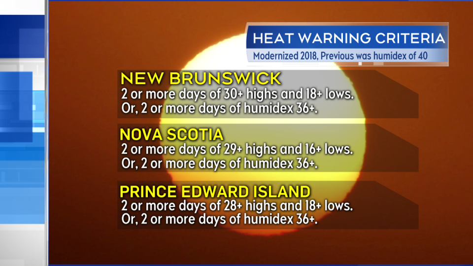
Criteria used for the issuance of Heat Warnings for the Maritime provinces.
People and pets should not be left in hot cars for any period of time. This applies to anytime we have sunny and warm-to-hot weather. Stay hydrated and take breaks to cool when possible. Watch the more vulnerable (young, elderly) for signs of heat exhaustion and stroke. That can include weakness, nausea, headache, muscle cramps, and in the most serious cases, a loss of consciousness or reduced mental ability.
Tuesday is likely to be the hottest, most humid day region wide. Most highs away from the coast are expected to reach the low-to-mid 30’s. Parts of the region will cool on Wednesday including eastern areas of New Brunswick, eastern areas of Nova Scotia, and Prince Edward Island as winds turn to the northeast tapping into cooler North Atlantic air. Some heat will linger for western New Brunswick and western Nova Scotia on Wednesday, though is unlikely to match up to Tuesday.
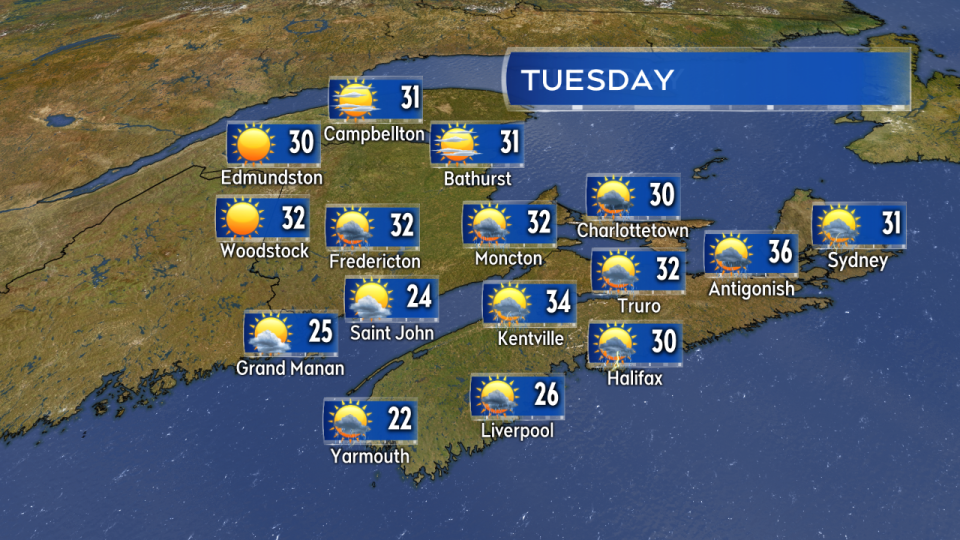
Tuesday is, in general, going to be the hottest day this week.
A round of cooler, less humid polar air arrives in northerly winds Thursday breaking the hot weather region wide. In fact temperatures on Thursday and Friday appear to run at least a few degrees cooler than climate averages for early June.
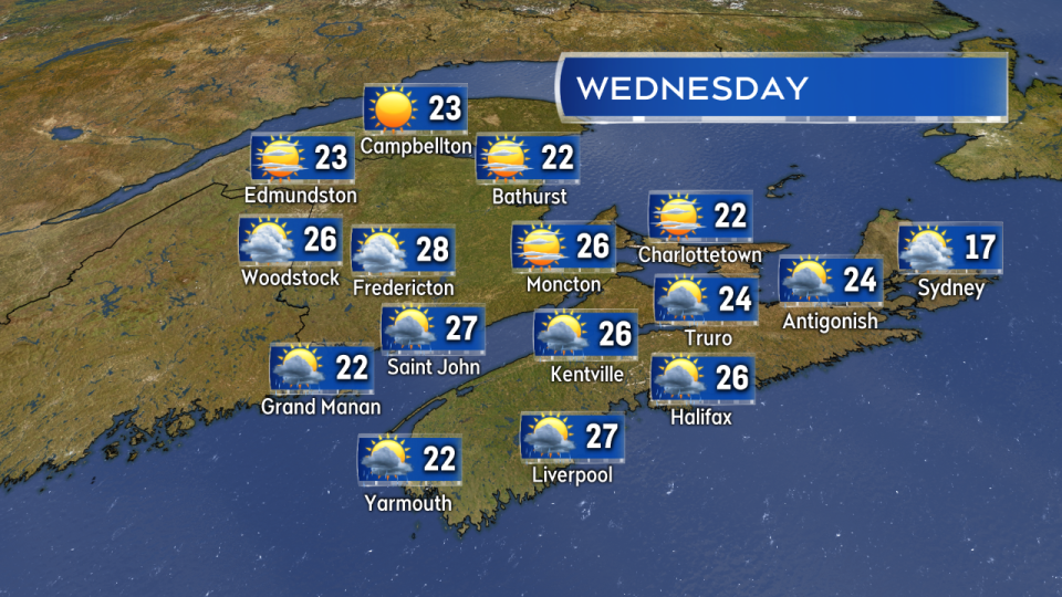 Temperatures begin to cool, especially for eastern areas. Temperatures much cooler region wide on Thursday.
A risk of thunderstorms often accompanies stretches of hot, humid weather. A line of broken thunderstorms may develop in central/southern New Brunswick on Tuesday moving into P.E.I. and eventually Nova Scotia. The thunderstorms should be watched for Tuesday afternoon and evening.
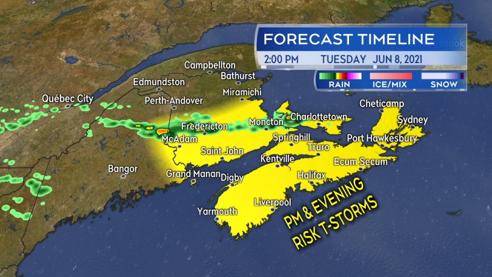
A broken line of thunderstorms may develop Tuesday afternoon into the evening. Thunderstorms should be watched for in central/southern New Brunswick, Nova Scotia, and Prince Edward Island.


